05/15/16

CARMONA (Vector de Morphart, 1890)

1GEO-blog-calvo-yepes

Morphart, autor de este grabado del año 1890, representó la aldea de Carmona desde el camino que sube por el alcázar. La imagen muestra el estado en que se conservaban algunas de las edificaciones en torno al año 1890, así como varias viviendas y el paisaje circundante característico del área rural. Carmona es un municipio de la ciudad de Sevilla, exactamente se encuentra a 30 km de ésta, en el margen izquierdo el río Guadalquivir. Domina la Vega de los Cordobeses debido a que está situada en una cota que contiene gran importancia sobre los Alcores.

En la imagen se muestra con gran claridad el centro urbano de Carmona, emplazado sobre una meseta con contorno irregular, donde se encuentran, por un lado, las iglesias y por otro, un conjunto de casas separadas por el camino principal. Respecto a esto, se aprecia una falta de unidad entre las calles, de trazado irregular y disperso, con distintos tamaños y formas en los grupos de construcciones, aunque con un predominio de parcelas o casas rectangulares. Cada uno de estos elementos urbanos se encuentra en una altura determinada de la aldea; esta distribución espacial está marcada tanto por condiciones económicas como sociales. El único camino que aparece en la imagen es estrecho y va respetando los elementos de la naturaleza, no es un camino recto sino que tiene algunas irregularidades desde el comienzo de la imagen hasta su fin, el cual es el propio centro de Carmona.

Entre los elementos urbanos más importantes destaca principalmente la iglesia principal y su aldea, que a partir de la construcción del Alcazar deja realmente de considerarse como aldea y comienza a ser un municipio de mayor relevancia. La iglesia que aparece al fondo de la imagen está dedicada a San Pedro y posee una torre conocida como Giraldilla. A pesar de que no están ubicadas en una de las zonas más altas del lugar, son reconocidas por su elevada altura y su estilo barroco, de ahí su importancia. En la parte derecha de la imagen se puede apreciar la presencia de población transitando por el camino que les comunicaba con el exterior y a la vez el centro de la ciudad. Sobre este camino, a la derecha, vemos parte del Alcázar Puerta de Sevilla, el cual ha tenido varios usos, ya que en algunos momentos sirvió como fortaleza y en otros momentos como palacio. En este edificio se encuentra una puerta que se considera de gran prestigio por servir como puerta de entrada a la ciudad romana y como forma de comunicación con la Puerta de Córdoba. Debido que en el alto de Carmona se construyó un castillo, cuya función primordial era para la defensa, el emplazamiento del municipio es típicamente árabe.

La población mayoritaria está formada por jornaleros, que en el siglo XIX se encontraban en unas condiciones muy precarias debido a la pérdida de terrenos y a su situación de arrendatarios no propietarios. A partir de finales de aquel período, en Carmona se comienzan a crear las primeras industrias relacionadas con la transformación de materias primas para la fabricación de jabones, harina, textiles, etc.

Como información adicional, tras comparar esta imagen de Carm0na en el año 1890 con otras del mismo lugar y mismo año, se puede apreciar que las diferencias no son muy notables, ya que todas ellas se centran en la representación de las edificaciones más representativas del momento. En cambio, si la comparación se hace con imágenes actuales, nos encontramos con un municipio mucho más edificado, aunque con un trazado que sigue siendo irregular, con calles estrechas y empinadas. En el caso de las imágenes de la década de 1890 no es posible dar toda esta información debido a que únicamente se han visualizado grabados centrados en determinados lugares de la aldea y no se puede apreciar ésta en su totalidad.

Nerea Calvo Yepes

05/15/16

MUNICH (Johann Stridbeck der Jüngere, 1700)

1GEO-blog-diaz-garcia

Este grabado es obra de Johann Stridbeck der Jüngere (1665-1714), y en él se muestra una imagen de la ciudad de Múnich en el año 1700. El autor plasmó diferentes monumentos simbólicos de la ciudad bávara como los dos bulbos de la Catedral, la Torre hermosa o la Iglesia Agustina. Stridbeck fue, junto con su padre, uno de los primeros editores de atlas más importante en lengua alemana en aquella época.

Múnich, se está emplazada sobre el río Isar y al norte de los Alpes Bávaros. Es la capital y ciudad más importante de Baviera, además de la tercera ciudad de Alemania por número de habitantes, después de Berlín y Hamburgo. La ciudad fue fundada en el año 1158 por el Duque Enrique el León. Por aquel entonces el terreno era propiedad de unos monjes, lo cual sirvió de inspiración para el nombre de la ciudad. Múnich posee diferentes influencias, como barrocas y rococós, en sus construcciones históricas del siglo XVIII, que con frecuencia se inspiraron en modelos italianos.

La ciudad presenta un trazado irregular en sus calles, con una estructura urbanística dispersa. El centro lo vemos rodeado por dos cinturones de murallas que fueron creadas para la protección de la población. Asimismo, el hecho de crear dos murallas fue determinante para la estructura urbanística de Múnich. La primera muralla se finalizó en el año 1175, con una longitud de 1,4 kilómetros, 2 metros de anchura y 5 metros de alto. Esta poseía 5 puertas principales, una de ellas, Das Kaufingertor, apreciable en el grabado. En la actualidad podemos admirar una pequeña estatua en su recuerdo, además de un centro comercial que lleva su nombre. Posteriormente en el año 1328, tuvieron que crear otra muralla ya que consideraron que la primera se quedaba pequeña por el crecimiento de la población. Esta contaba con una longitud de 4 kilómetros, una anchura de 2 metros y altura de 9 metros. Hoy en día, no se conserva en su estado original nada del primer cinturón de la muralla, pero sí que se ha respetado el antiguo trazado de las calles.

En la imagen se pueden apreciar diferentes elementos significativos para la ciudad alemana. Los más representativos serían la Iglesia Agustina (Agustinerkirche) construida a finales del siglo XIII, que tuvo que reconstruirse en diferentes ocasiones, convirtiéndose en el primer edificio barroco de la ciudad. Hoy en día podemos encontrar allí el Museo de Caza y Pesca donde hay una recopilación de armas de caza, animales disecados y trofeos, entre otros. Otra construcción emblemática que se puede apreciar es la Catedral de Nuestra Señora de Múnich (Dom zu Unserer Lieben Frau); es la catedral gótica más grande del sur de Alemania, con una estructura con ladrillo rojo y estilo gótico tardío. Esta edificación comenzó en 1468, y finalizó con la construcción de sus dos torres en el año 1488; dichas torres acaban en dos bulbos sobre los cuales tuvo gran influencia el arte bizantino. Su altura es de 109 metros y 40 de ancho. Destaca también el altar Memminger, construido en 1994, que incorpora los relieves y una Virgen de estilo rococó, además de la Chorhauptkapelle. Actualmente, es una de las edificaciones con más importancia turística de la ciudad.

Por otro lado, en el grabado podemos apreciar una gran afluencia de personas sobre la recta empedrada. Este movimiento en la imagen se puede achacar a la importancia de la ruta Salzburgo – Augsburgo, donde gran cantidad de comerciantes de sal circulaban a diario. Para lucrarse de ello el Duque Enrique el León comenzó a cobrar peajes por el paso del puente sobre el río Isar (construido en 1158), gracias a lo cual la ciudad comenzó a crecer de manera considerable. Asimismo, en la imagen se aprecian los carruajes y caballos que se utilizaban en la época como forma de transporte. También alcanzamos a observar las vestimentas del grabado, que por la elegancia de los vestidos se considera que el autor quiere brindar importancia a una clase social alta. 

Natalia Díaz García

05/14/16

VIENA (Carl Graf Vasquez, 1830)

1GEO-blog-lajarin-jimenez

Este plano representa la ciudad de Viena todavía amurallada en el año 1830. Fue elaborado por Carl Vásquez (1798-1861), un oficial y cartógrafo austriaco que realizó importantes planos de la ciudad, tales como, por ejemplo, el “Plano de situación de la capital y residencia de la ciudad imperial de Viena”, así como otros planos detallados de los antiguos distritos. Viena es una ciudad de Europa central, capital de Austria, situada a orillas del Danubio y al pie de la cordillera de los Alpes. Podemos decir que es una de las capitales más antiguas de Europa y cuenta con un importante patrimonio histórico-artístico.

Viena fue fundada hacia el año 500 a. C por tribus de origen celta, quienes la nombraron Vedunia, es decir, «arroyo boscoso». Posteriormente fue habitada por los germánicos y más adelante por el Imperio Romano, quienes la llamaron Vindobona o «ciudad blanca». El Danubio servía de frontera natural entre el mundo romano y los barbaros pero, además de sus funciones defensivas, el río adquirió una importante función comercial y de comunicación. En la imagen que vamos a comentar se puede apreciar cómo era el plano de Viena hacia el año 1830. En aquella época, Viena había sido conquistada por Napoleón Bonaparte y se encontraba en fase de recuperación. A partir de octubre de 1814 se convirtió en la sede de una gran conferencia internacional llamada el Congreso de Viena, que tenía como objetivo restablecer las fronteras de Europa y reorganizar la política de las principales monarquías del Antiguo Régimen. Como consecuencia del congreso, Austria recuperó sus posesiones en los Balcanes, Lombardía y el Véneto, perdidas durante las Guerras Napoléonicas.

Podemos decir que Viena tenía una estructura acorde a la muralla, y en su interior se encontraba la ciudad, dividida en cuatro barrios o zonas denominados Schottenviertl, Wimmerviertl, Karnthervierl y Stubenviertl; cada uno de ellos está representado con un color diferente. La morfología o trazado que vemos en el plano es de tipo irregular, ya que la ciudad no presenta un esquema diferenciado, y las calles están todas ellas cruzadas, sin tener un esquema fijo. En el centro encontramos una plaza, la plaza de Graben la cual era el punto neurálgico de la ciudad, y alrededor de ella se fueron construyendo los edificios. Además de esta plaza, podemos encontrar que había muchas más, como por ejemplo, Burgplatz, Am Hof, la plaza de San Esteban, la plaza de Juden… Estas plazas servían como espacios abiertos para el encuentro social, el intercambio comercial, el ocio o incluso para actividades de representación pública. También vemos numerosos jardines como el “Volksgarten” que significa jardín del pueblo, que ostentaban fuciones de recreo y esparcimiento. Además, también encontramos señalados varios mercados, como el mercado de Neu y el mercado de Hoher. Para aquella época ya había muchos edificios importantes en la ciudad, como la catedral de San Esteban, que data del siglo XII y es de estilo gótico. Asimismo, se distinguen varias avenidas como, por ejemplo, Herrengasse y Kamtner Strasse, la cual iba desde la plaza de San Esteban hasta la muralla.

Finalmente podemos añadir, que al centro histórico de la ciudad hoy en día se le llama Innere Stadt, y ocupa todo lo que se encontraba en el interior de la muralla. El espacio que dejo la muralla, al ser derrumbada, hoy en día se llama el Ring, y es una ronda o anillo de circunvalación del cual salen diversas vías radiales que van hasta el Gürtel, que sería el ensanche de la ciudad. Seguido del ensanche ya se encuentran los barrios periféricos con las industrias de transformación. Dicho ensanche podemos decir que ya es de finales del siglo XIX y principios del XX, el cual se desarrolló a partir de la demolición de la muralla.

Raquel Lajarín Jiménez
 

05/13/16

NUEVA YORK, Times Square (Marti Bofarull, 2014)

Diapositiva1

La imagen seleccionada nos lleva hasta Nueva York, hasta el propio centro de la cuidad, entre la 7ª avenida y Broadway. Se trata de una pintura realizada por Marti Bofarull en el año 2014, que representa la zona más concurrida de Manhattan, Times Square.  Antiguamente, este lugar era conocido  como Long Acre Square pero en 1904 la plaza fue rebautizada cuando la sede del periódico The New York Times se mudó al New Times Building, en la confluencia con la Calle 42, lugar que ahora se conoce como el One Times Square. En la fabulosa década de 1920, Times Square se convirtió en el nuevo centro cultural de la ciudad de Nueva York, y se llenó de teatros, hoteles y salas de conciertos musicales. También en esta época, artistas famosos como Charlie Chaplin y Fred Astaire visitaban con frecuencia los magníficos escenarios de Times Square.

La ciudad de Nueva York se encuentra situada al noreste de los Estados Unidos, en el estado de Nueva York. Tal y como la conocemos, Times Square tiene una historia relativamente creciente ya que, hasta finales de los años 90, esta zona era sinónimo de crimen y drogas. En 1992, el Times Square Alliance en colaboración con el gobierno municipal iniciaron una serie de actuaciones para que el lugar mejorase en cuanto a interés turístico se refería, y finalmente los estudios de ABC y otras compañías financieras se instalaron allí. Hoy en día es la zona mas viva de Manhattan y donde se puede encontrar prácticamente de todo. El área urbana está formada por las manzanas situadas entre la Sexta Avenida y la Octava Avenida que juntas, constituyen la parte occidental de la zona comercial de Midtown de Manhattan.

En cuanto a su morfología, Nueva York es una ciudad compuesta en altura por muchos rascacielos. La edificación de estos edificios es muy significativas tanto para los empresarios como para los turistas. El trazado de sus calles presenta un diseño ortogonal y en la morfología urbana predomina una línea recta que corta las calles dejando bien definidas las calles por cuadriculas. Como se puede apreciar en la imagen, Times Square cumple todos estos requisitos, con la peculiaridad de que es una gran diagonal (Broadway) la que corta la cuadrícula, dando a la plaza una curiosa forma triangular.

Actualmente Times Square es una plaza peatonal donde los viandantes pueden sentarse en las sillas y bancos que hay situados a ambos lados de la calzada pero anteriormente esto no era así ya que el transito de los coches era constante y las personas que querían disfrutar de las vistas tenían casi imposible poderse hacer una foto o caminar despreocupadamente. Ahora serán los pasos de la gente los marquen el ritmo del corazón de Manhattan. Ciertamente, este lugar posee una de las mejores vistas de toda la cuidad aunque sea de manera artificial. Los edificios altos y los más de cincuenta carteles que iluminan la zona hace que se mezcle la mano del hombre con un enclave de edificios de gran altura que nos llevan a visitar uno de los lugares más famosos y fascinantes del mundo. Las medidas de seguridad, no obstante, han aumentado como consecuencia de los atentados del 11 de Septiembre. A pesar de lo cual, el 6 de mazo de 2008 una bomba estalló cerca de una de las oficinas militares provocando sólo daños menores.

Lucía Silgo Terol

05/11/16

VALENCIA (Nicolas-Marie Chapuy, 1844)

Diapositiva1

Este grabado diseñado por Nicolas-Marie Chapuy, representa el entorno de la catedral de Valencia en 1844. Se conserva en el Museo de la Ciudad de Valencia y fue publicado en 1999 por Miguel Ángel Catalá, en el libro Valencia en el Grabado, 1499-1899, editado por el Ajuntament de València, 1999.

Nicolás Marie Joseph Chapuy (París 1790, 1858) fue un arquitecto, paisajista y litógrafo francés que estudió en la Escuela Politécnica de París, trabajó como arquitecto municipal e intervino en la restauración de importantes monumentos medievales, hasta que en 1817 se retiró por su adhesión al movimiento de Bonaparte. Más tarde, como artista independiente colaboró con arqueólogos y visitó todos los cantones del estado francés, haciendo una colección de pinturas en la que destacó los elementos naturales y culturales de cada rincón. Fue en 1842 cuando Chapuy comenzó a pintar por España, y ese es el contexto en el que se sitúa esta imagen.

En la cromolitografía, el autor recrea con una gran pulcritud y sensibilidad, una escena costumbrista de la Valencia de mediados del siglo XIX. Una ciudad laboriosa, burguesa y a la vez artesana y huertana. En primer término observamos a la pareja de huertanos que, a buen seguro, han venido a la capital para traer los productos de la huerta. El carro con las enormes ruedas era el transporte comúnmente utilizado para trasladarse de un punto a otro. Las fuerzas del orden dan un aspecto de control y de seguridad mientras los viandantes disfrutan de una mañana soleada del otoño valenciano.

La ciudad de Valencia fue fundada por los romanos en el año 138 a.C. con el nombre de “Valentia Edetanorum”. Desde el principio fue punto estratégico tanto para el intercambio comercial como para el abastecimiento de víveres al ejército, dada su ubicación en el centro de la costa mediterránea. Valencia es una ciudad marítima, se sitúa en la llanura litoral del golfo que lleva su nombre y está asentada en un altozano, sobre un meandro del río Turia. Tiene una extensión de más de 30 km. de norte a sur, y de este a oeste apenas supera los 7 km.

A mediados de 1800 la ciudad de Valencia se va recomponiendo tras los duros años de guerra contra los invasores franceses de Napoleón. Se termina la instalación de aguas potables en la ciudad, se diseña el proyecto general de ensanche y a partir de 1866 se derriban las antiguas murallas para facilitar la expansión urbana, quedando en pie únicamente las dos puertas principales de la ciudad: la Puerta de Serranos y la Puerta de Quart. En 1882 comienza a instalarse el tendido eléctrico y se genera un nuevo plan de ensanche que dará lugar a la creación de las dos grandes vías: La Gran Vía Marqués del Turia y la Gran Vía de Fernando el Católico. También a partir de 1800 se anexionan muchos municipios inmediatos a la ciudad como son los barrios marítimos o los municipios de Patraix, Orriols, Benicalap, Ruzafa, Benimaclet, Campanar, etc. En conjunto, la población de Valencia en la 2ª mitad del siglo XIX aumentó extraordinariamente de 137.960 habitantes a 213.550.

Morfológicamente, la ciudad de Valencia queda dividida por el cauce del rio Turia en dos partes. En la parte superior se sitúa el centro histórico de la ciudad con calles tortuosas y estrechas, y edificios muy juntos unos de otros. La primera ronda de circunvalación de la ciudad, que marca el perímetro de la denominada Ciutat Vella, está formada por la calle Colón, eje comercial de la sociedad valenciana contemporánea, la calle Játiva, la calle Guillén de Castro y el gran cauce lateral del rio sirve de nexo y cierre de la ronda. La siguiente circunvalación está formada por las grandes vías de Fernando el Católico y del Marqués del Turia.

La parte inferior del cauce del rio Turia fue considerada durante muchos años por los valencianos como de segundo orden ya que la mentalidad de la población era que cruzar el rio suponía vivir muy lejos. Prueba de ello fue que su expansión fue más lenta. En la actualidad, Valencia se ha expandido considerablemente tanto hacia un margen como hacia el otro del rio, y los diferentes puentes que a lo largo de todo el cauce unen un margen con otro se han convertido en ejes de comunicación vitales para la ciudad. Entre los más importantes están: el Puente de Los Serranos, enfrente de las Torres de Serranos, el Puente de San José, el Puente de Trinitarios, el Puente del Real que comunica la ciudad con el jardín de los Viveros, el Puente de la Exposición, llamado así porque comunicaba la  margen superior con la Alameda donde se celebró la famosa Exposición de Valencia en 1929. Luego se construyeron otros puentes, siendo dos de los más conocidos el denominado De las Flores, y el de Calatrava.

Tras la terrible riada de 1957 en la que el rio Turia causó unos desastres importantísimos, se aprobó el Plan Sur y se construyó un nuevo cauce en el extrarradio de la unidad para prevenir futuras inundaciones. Desde entonces, el viejo cauce se ha convertido en un maravilloso pulmón para la ciudad con numerosas zonas deportivas, instalaciones multi usos y de expansión para todas las edades, destacando la Ciudad de las Artes y las Ciencias.

El origen de la Plaza de la virgen, representada en esta imagen, se remonta al foro de la época romana y está situada en la confluencia de las dos grandes vías propias de toda ciudad romana: “el cardo” que aproximadamente coincide con la calle de S. Vicente, y el “decumano” que se corresponde a la actual calle de los Caballeros. La Plaza de la Virgen se sitúa pues en el distrito de Ciutat Vella, es una plaza de forma irregular aunque tiende a ser un cuadrilátero. Hoy es totalmente peatonal y los edificios más emblemáticos que la componen son los siguientes: la Basílica de la Virgen de los Desamparados, los jardines y el palacio de la Generalidad, la Casa Vestuario, que sirve de reunión a los miembros del Tribunal de las Aguas y en su fachada tiene una placa conmemorativa de la visita que S. Juan Pablo II hizo a Valencia en diciembre de 1982.

Los accesos a la Plaza son los siguientes: por el norte, la Calle Navellos donde se encuentra el palacio de Benicarló, sede de las Cortes Valencianas, y que en su último trama denominado calle del Muro de Santa Ana, se comunica con el cauce del rio Turia; por el sur, la Calle del Miguelete, que bordea la catedral y une la Plaza de la Virgen con la Plaza de la Reina; por el oeste, la Calle de Caballeros, lugar de residencia de la antigua nobleza valenciana y que acaba en la Plaza del Tossal; y por el este, la pequeña Plaza de los Coros de la Virgen que la une a la Plaza del Almudín.

La plaza acoge diferentes e importantes acontecimientos tanto religiosos como populares, entre los cuales podemos citar las reuniones semanales del Tribunal de las Aguas, delante de la Puerta de los Apóstoles de la Catedral de Valencia, que aparece reseñado en la litografía motivo y núcleo de este trabajo. Este Tribunal se reúne cada jueves para tratar los conflictos entre los regantes de la Vega de Valencia por el uso de las acequias. Es el único Tribunal en el que no se escribe nada, todo es oral y en lengua valenciana. Otras actividades significativas son la Ofrenda de flores a la Virgen de los Desamparados que todas las comisiones falleras, Junta Central fallera, casas regionales etc.., hacen a la Virgen los días 17 y 18 de marzo durante la semana fallera. Además, el 2º domingo de mayo, fiesta de la Patrona del Reino de Valencia, se celebra la Misa de Infantes, el popular traslado de la Virgen de su Basílica a la catedral y la solemne procesión vespertina que la devolverá a su Basílica. Por último, la exposición de las Rocas o carros que toman parte en la procesión del Corpus Christi; durante todo el año, las Rocas están custodiadas en la Casa de las Rocas.

Hasta la 1ª mitad del siglo XIX el modelo de sociedad de Valencia se centraba en el modelo rural fundamentada en una actividad agrícola. En la 2ª mitad se comienza una expansión por la exportación de los cítricos que abrirán nuevos cauces a la economía. El puerto cobra relevancia, se construye la Avda del Puerto que unirá este a la ciudad. A partir de este momento, la ciudad empieza a desarrollarse más rápida que la huerta. En la sociedad se produce un cambio radical, la decadencia del clero y la nobleza dan paso a una burguesía urbana que había comprado las tierras tras la desamortización pero que era ajeno a todo lo que significaba la huerta, esto ocasionó graves tensiones con los arrendatarios que provocaron graves altercados a finales del s. XIX. Así, la agricultura, la y el sector financiero se dinamizaron por las numerosas innovaciones  que se la revolución industrial trajo consigo.

Mª Amparo Prats Martínez

04/29/16

VIENNA (George Braun & Franz Hogenberg, 1617)

IMAGEN

This image belongs to a collection of engravings of urban plans entitled Civitates Orbis Terrarum, published by Georg Braun, a German geographer and cartographer, and Franz Hogenberg, a German painter and engraver. This work was conducted between 1572 and 1617, just before the extensive devastation caused by the Thirty Year’s War. This great city atlas eventually contained 546 prospects, bird-eye views and map views of cities from all over the world. Among them we can admire this representation of the imperial capital of Austria, Vienna.

Vienna is placed on the riverside of the Danube river, in the oriental part of Austria. The river connects Central Europe to the Black Sea and has been used as a natural border many times throughout history. Concerning its specific geographical location, Vienna is in the Valley of the Vienna Woods, at the foot of the foothills of the Alps. The appearance of the city seems to be irregular, though we can see zones on the bottom left that looks like orthogonal. The property consist of medieval core, a former military Roman camp. Its remains stills visible in the urban medieval fabric of streets and alleys. In the 12th century, the urban development expanded beyond the Roman defences, which were demolished. The walls of the medieval city surrounded a much bigger area and were reconstructed after the Ottoman conflicts in the 16th and 17th century. The urban and architectural qualities of the Historical Centre of Vienna give exceptional testimony for a constant exchange of values along the second millennium.

Concerning the buildings inside the city, they show the big changes that the city of Vienna experienced from the Middle Ages to the Renaissance, as the Baroque period had not begun yet. This bird-view is considered to be one of the principal historical sources to know the appearance of the Gothic architecture of the city. Supposing that the monastic complexes and churches were generally constructed of stone, the residential neighbourhoods were of wood and suffered frequent fires. Out of the wall there are also houses, which is typical of the cities of the Modern Age because the medieval hulls were insufficient. The cities incorporated squares, gardens, sewerage, paving, etc. in their streets. The biggest and more significant streets were placed downtown, around important elements, as St Stephen’s Cathedral.

Thus, the interior of this city contains a number of medieval historic buildings, including the Schottenstift (the oldest monastery in Austria), the churches of Maria am Gestade (one of the most emblematic Gothic structures), Michaelerkirche, Minoritenkirche and Minoritenkloster. Saint Stephen Cathedral is dated between the fourteenth and fifteenth centuries, and clearly dominates the picture. It is crowned by a needle-shaped tower (Steffl), built in Gothic style, which is one of the most important religious symbols of Vienna.

Regarding the social activities, in the town centre there is a square where it is very possible that people devote to trade among other activities. Just outside the walls there are different groups of population: people at the top of the image seems to practice animal husbandry or trade. As we go down to the left, we can see men carrying goods. Then we stumbled upon the “Fort Boarium”, or the pork market of Vienna; and below we can see some passenger cars pulled along by horses. In the foreground we can see a large number of people carrying things and some of them look like being warriors. In the river we can see many boats, some fishermen and other merchants, because the salt trade was an essential activity at that time; although there are people who walk by crossing the bridges they had. The boats were made of wood to the edge that is on the right. At the top right, we see a line of people waiting to enter into the city, so we assume they were new immigrants in Vienna. The landscape in the surrounding area is formed by green plains, so we can deduce that agricultural activities are practiced. In the background of the image we can see a few mountains; on the other hand, in the foreground there is a river. The nearness of this one offers to the city supply of water and fish, and provides a trade route. We cannot forget that access to raw materials is essential in order that a city could develop correctly.

The imperial family Habsburg reigned in Austria and other Central European countries from 1278 to 1918. The struggles between Catholics and Protestants (Habsburg defended Catholicism) and the Turkish threat overshadowed the political life of Austria in the 16th and 17th centuries. The Peace of Westphalia (1648) and the Peace of Carlowitz (1699) ended, respectively, to both problems and consolidated the position of Austria as a European power. The Habsburgs made the city their capital from 1556 and its importance was enhanced with the expansion by the valley of the Danube. It became a core of European Baroque thanks to the construction of major architectural works and musical creations (from the 16th century, Vienna has been universally recognized as the musical capital of Europe).

Olga Arriero Gallego

04/26/16

SALT LAKE CITY (Thomas Kinkade, 2005)

Salt Lake City (Thomas Kinkade 2005)

This painting is entitled “Salt Lake: City of Lights” and the author is the very well-known American artist Thomas Kinkade (1958-2012). It was made in the beginning of the XXI Century and represents a view of Salt Lake City, in 2005. The painting captures the city of Salt Lake at sunset, and displays some significant urban elements such as  The Church of Jesus Christ of Latter-day Saints, The Joseph Smith Memorial Building, named after Joseph Smith, founder of the Mormon religion, and The Utah State Capitol, which is the headquarter of Utah State.

Salt Lake City is situated to the North of the Utah State and to the Northeast of The Salt Lake Valley, surrounded by the Great Salt Lake to the Northwest and the Wasatch and Oquirrh mountains in the Eastern and Western frontiers respectively. The Great Salt Lake is separated from the main city by large swamps and marshlands, and the metabolic activity of the bacteria within them gives birth to a phenomenon known as “lake stink”, a scent that is reminiscent of rotten eggs, twice a year during a few hours. The highest point in Salt Lake City is Twin Peaks, at the Southeast of the Wasatch mountain chain. This mountain chain, with the Oquirrh hills and the Great Salt Lake defines the topographic characteristics of the city.

The city plan is based on parallel and perpendicular streets that meet on the main points of the city, such as The Church of Jesus Christ of Latter-day Saints, The Joseph Smith Memorial Building and The Utah State Capitol among others. This street distribution results on a draughboard design. The main downtwon streets are extremelly wide, due to the original idea that took into account that a cart could easily move in any of the avenues. The Church of Jesus Christ of Latter-day Saints started its construction the 6th of April of 1854, but during the Utah War the foundation of the church was burried. It stayed this way until 1858, when the efforts of constructing the temple were resumed and it was discovered that the original foundation had crumbled. A new quartz foundation replaced the old one and the temple was successfully finished in the 1890s. Today it is one of the main touristic attractions of the city and also the centre of the Mormon religion in the State of Utah. The interior of the Church is strictly prohibited for those who aren’t mormons, but the square of the Temple is full of volunteers and missionaries that gently offer 30 minutes tours in 30 different languages.

To our left, we can see the Utah State Capitol, a building designed in 1916 by local architect Richard K. A. Kletting, who also designed the Enos Wall Mansion, now a landmark for the Last-day Saints Bussiness College campus. This Capitol underwent one of the largest historical preservation projects in the United States from 2004 to 2008. The Project had as its goals to protect the building against posible earthquakes and to repair and restore the original artwork. We can also appreciate on the right section of the painting the Joseph Smith Memorial Building, that was built betwenn 1909 and 1911. This building takes its name from Joseph Smith, founder of the Latter Day Saint movement (also known as Mormon religion). Its location is on the corner of the Main Street and South The Church of Jesus Christ of Latter-day Saints. At the centre of the canvas we can appreciate skyscrappers who are the result of more modern city designs as well as the creation of a Central Business District for the city.

A mayor for the city was chosen for the first time in 1911, Samuel C. Park, who focused in updating the precarious infrastructures of the city. In 1929, due to The Great Depression, lots of the citizens lost their jobs and homes and were forced to live in the streets. However, by the end of the World War II the city rose and recovered its economy. During the XXIst century a Financial District was created in order to strengthen the economy of the city. Salt Lake City held the Winter Olympic Games in 2002, and due to its dinamic and cosmopolitan society, it is no surprise that nowadays is a city where various artistic and cultures currents meet, making Salt Lake City one of the most liberal cities in the United States.

Íñigo Monje Vigón

04/25/16

STOCKHOLM (Påhlman & Hanzon, 1930)

FOTO BLOG

This map represents the shape of Stockholm city, in Sweden, during the XX century (1930). It has been found in a government website where a lot of old maps are displayed. The only information related to the publishers is that the image was emitted by the Mayor State Pahlman and Hanzon (Generalstaben genom Påhlman och Hanzon). The importance of the map is that it shows the distribution of the city in several islands and its expansion and evolution due to the population growth in nineteenth century. Since its origins in the thirteenth century to defend the Malar Lake area and promote the sea trade, Stockholm became one of the main cities in Sweden due to its strategic geographical position. However it did not grow much until the mid-nineteenth century with the Industrial Revolution, when many industries were located in the capital, causing high immigration from the field and creating the urban structure showed by this map.

According to the layout and the social and economic issues, it is clear that this city is composed by  several islands over the Malaren Lake connected by bridges. Interestingly, we can point out two different shapes of urban spaces attending to the age of the islands: the center of the map (Gamla Stand and Kungsholmen islands), which follows and irregular town planning, and the north and south of the map (Normalm, Ostermalm and Sodermalm), where the expansion of the new city was emplaced following a regular urban structure.  Gamla Stand is the old town of Stockholm and it has an irregular layout with narrow cobbled streets and medieval german style buildings. Due to population growth in the nineteenth century, as the picture shows, the expansion area (Normalm and Ostermal) started to emplace new markets, shops, the central station with the railway system, and important squares, becoming a new commercial and financial center. As a result, Gamla Stan stopped being the main center of the city, and Normalm and Ostermal started to expand following a regular town planning based on a reticular expansion with rectangular blocks and open squares. These expansion areas were connected to Djugarden district by a bridge in order to keep in contact to the leisure island in Stockholm. Innovations in transportation can also be seen in the map in the railway line, built in 1860. The railway follows the river in the north to promote the commercial trade, goes over the water through the central island, Helgeandsholmen, where the administrative center is located (Swedish parliament), and continues on the south where it is divided on the east along the coast (Sodermalm) and on the west through the city. This railway settlement emphasizes the foundational idea of Stockholm as a port city.

Regarding to the monuments displayed in the map, there are a lot of outstanding buildings that determined the layout of the city and the uses of each island. For example, the little island located in the center of the picture contains only one building, The Swedish Parliament. In addition, there is an island dedicated to citizen´s leisure where there are important elements, such as the first open air museum and amusement park in the world. Lastly, is needed to highlight that the most remarkable building in the map is the Royal Palace, located the old town (Gamla Stand). The first building emplaced in this place was a fortress with a central tower built created in the thirteenth century by Birger Jarl in order to defend Lake Mälaren. The fortress grew into a palace, called Tre Kronor («Three Crowns»). In the late sixteenth century many works were made to transform the old fortress into a Renaissance palace under the reign of King John III. At the time of this map, 1930, the royal family still had residence in this palace. From 1981, they set the Drottningholm Palace as a real residential in the outskirts of the city.

To sum up, according to the social activities, in the thirteen century, the main activity in Stockholm was the sea trade because of its location in Malaren Lake. After industrial revolution in XIX, this city became in an economical area based on industry (exportations of wood and other raw materials), and services such as tourism, finances or new technologies.

Ana Orche de Tomás

04/25/16

SALAMANCA (Anton Van Den Wyngaerde, 1570)

presentacion-powerpoint-pg2

This is a drawing that represents a view of Salamanca from El Arrabal, in 1570. It was made by Anton Van Den Wyngaerde in 1570 and has been collected for a project by Silvia García Alcázar and Fernando González Moreno at the University of Castilla and León. Wyngaerde was a Flemish artist who was commissioned by King Felipe II to visit Spain and draw a number of views of many Spanish cities between 1561 and 1570.

Salamanca is located in the Comunidad Autónoma de Castilla y Leon. Its origins are dated about 2,700 years ago during the Early Iron Age, when the first people who inhabited this land settled on the hill of San Vicente, on the banks of the Tormes river. Since that moment, the city has been inhabited by different people, such as Vacceos, Romans, Visigoths and Muslims. Raimundo of Borgoña, son of King Alfonso VI of Leon, was in charge of repopulating the city during the Middle Ages and laid the foundations for the current Salamanca.

As we can see in the engraving, there are three parts in the city: the old quarter, the outskirts and the Tormes river, which was used as a natural border as well as a way of defense. The town has a typical medieval structure, which means that does not have a fixed pattern as conform to the historical and geographical circumstances. The streets have an irregular layout, but are organized with the aim of forming a unitary space. In addition, this type of cities is organized in neighborhoods that each has often his own political organization. Usually, in the city center lived the rich people with high purchasing power, while the poorest occupied the outskirts, outside the walls. The construction of city walls aimed to protect and defend the town. They were built around the city to protect citizens from possible diseases, epidemics or potential wars and attack enemies. In the picture it is possible to appreciate some gates in the city wall (Gate of Zamora, Gate of Toro, Gate of Sancti Spiritus), as well as a number of cottage located outside the wall above left.

In this picture it is shown the Old Cathedral of Salamanca, founded by Bishop Jeronimo of Perigord, the first bishop of the Diocese of Salamanca. As a curiosity, the Cathedral originally had three naves, semicircular apses and a famous garland dome in the transept as it was common in Romanesque style. The cathedral also has two towers at the foot. Later, it was constructed a second Cathedral in Gothic style, joined to the previous one. That is a truly rarity in Art History.

Near the Cathedral we can see the University of Salamanca. It is one of the oldest universities in Spain, founded in 1218 by King Alfonso IX. In this university some teachers have taught distinguished classes throughout history, such as Fray Luis de León, Beatriz Galindo, Melchor Cano, Francisco de Vitoria and Miguel Unamuno. A surprising fact is that within the halls of this university many important figures that have passed into history, for example Miguel de Cervantes, Hernando Cortes and Christopher Columbus.

In the image we can also see the Roman bridge crossing the Tormes river and being part of the Via de la Plata, one of most important ancient Roman roads. This bridge is made of stone, much of it rebuilt by King Felipe IV in 1677. The Tormes river is a tributary of the Duero river; it starts in Avila province and flows into the Duero river. It is very important for the city of Salamanca because it works for water supply and many women washed their clothes down the river. Both the bridge and the river has been featured in famous works of literature such as Lazarillo de Tormes. In the XVI Century, Salamanca was a very important city thanks to its university and also its cattle fair and other commercial activities. It was the Golden Age for the city.

Paula Cecilia González

04/25/16

ALEXANDRIA (Henry de Beauvau, 1615)

FOTO BLOG

This engraving is part of the book Relation journaliere du voyage du Levant, a collection of 47 drawings and maps, written in 1615 by Henry de Beauvau, a soldier and traveller in the Middle East. The image is adapted from the original published by Georg Braun and Franz Hogenberg in the first volume of Civitates Orbis Terrarum, an atlas of cities of the world that was published in Cologne in 1572. It represents the city of Alexandria, which is the second largest urban area in Egypt after Cairo.

Alexandria is located in the north of the country, in a peninsula of the Nile delta. The site was chosen by Alexander the Great in 331 BC because it was considered a safe natural harbour for his fleet, in addition to the healthy climate, abundant fresh water and limestone quarries nearby to supply its future constructions. Alexander was also responsible for organising the urban planning, that followed an orthogonal distribution with parallel and perpendicular streets. However this urban layout was destroyed during the Middle Ages because its inner development turned into irregular. Nowadays, only two parallel streets in the interior still remain from the original structure.

The city was surrounded by a wall of 15 km. Outside this city wall, it is possible to appreciate the outskirts and the cropfields. Also, a channel was built to communicate Alexandria with other cities and another ports located in the mouths of the Nile Delta. We can also see some monuments such as the Pompeyo Column, the Garophalo Lighthouse, the seaports and several orchards. Alexandria was a city with many characteristics of Greek and Roman architecture and urbanism; it had numerous temples, palaces, theatres, baths, gardens, etc. The lighthouse of Alexandria is recognized as one of the seven wonders of the world. It has a height of 134 m and was for centuries the tallest man-made building in the world. After suffering two earthquakes in 1303 and 1323, it was destroyed. The city also housed the most important library in history. It was simultaneously a museum, a school and a centre for educational research. It held the largest number of existing Greek texts in the classical world. Unfortunately, this library suffered a fire in the fourth century. There is now a new Library Alexandrina on the same site, which opened in 2003.

The geographical location of Alexandria between the Nile river and the Mediterranean sea allowed it to become the most important city of the ancient world. Modern archaeological digs have found remains of goods from around the world, from Chinese ceramics to Moroccan dyes. Regarding the local industry, there was a high production of silk, embroidery, cotton and wool. Warehouses were built to store and distribute spices. Thus, the role of the harbour was fundamental for the Egyptian economic development. Besides, the cropfields located on the shores of Lake Mareotis produced wheat, grapes and olives. These products not only supplied the city but were also exported. An interesting example is the Alexandrian wine found in some amphorae in Marseilles.

Since ancient times there have been two ports in Alexandria. The western port was used by fishing boats. An interesting point about this port is that it holds 80% of all foreign maritime traffic in Egypt. In addition, it can accommodate up to 250 large ships in the terminal of the Suez-Cairo pipeline located in Alexandria. Also, there is an oil refinery, a mall and many stores, making it the best port in the eastern Mediterranean. In comparison, the eastern port is less important and is used as a marina.

Today Alexandria is a modern city with a quadrangular urban structure. It is an important cotton textile trade centre in addition to chemical, mechanical, shipbuilding and banking industries. Almost all of the ancient monuments and works of art that speak about the history of Alexandria are scattered around the world. Unfortunately, most were stolen. In present Alexandria city we can only find a few remains of what was once an imperial city. Archaeological work continues to rediscover the past of the city, much of which is under water.

María del Mar Díaz López

04/25/16

TALAVERA DE LA REINA (Eduardo Gil, 1990)

1GEOB-santos-rosa

This ceramic piece was created in 1990 by Eduardo Gil, an artist from Talavera who worked in Antonio Gonzalez Duran’s workshop. Talavera is very well-known for its ceramic artworks and these two people are some of the main craftsmen in the city. It represents the city of Talavera de la Reina (Toledo), located in the Northwest of Castilla-La Mancha. This ceramic piece depicts the city from the point of view of the outskirts, on the other side of the bridge over the Tajo River. Since that time, the city of Talavera has not undergone many urban changes.

Talavera is located in the West of Toledo province and its historical origin is Pre-Roman. The city is settled next to the Tajo River. A lot of different civilizations have been interested in Talavera since its creation. First, the Romans were amazed by its natural landscape and wanted to make this place their property; therefore, they called it Caesarobriga. Right after the Fall of the Roman Empire, the Visigoths conquered the city and left remains like the Villa del Saucedo. Finally, the Arabic kings thought that Talavera would be a good place to settle down, both due to the city location and the natural resources. Some historical testimonies and collections of samples can be admired at the ethnographic museum. It is located in Lagar de San Jerónimo, near the Convento Jerónimo.

Talavera has irregular urban layout due to the population increase in 1876. That is why there are some places that were constructed without a plan, but in later expansions to the east and the west, the buildings were constructed with a regular plan. The main economic source in this period of time was the manufacturing of ceramics, cotton mills and sewing circles. But nowadays, Talavera has some big factories and companies that export other products to the rest of the world. At the bottom of the picture, we can see the Tajo River, which, years ago, used to be a natural barrier of defense, and served as a supply for the people of the city. The river separates the city in two parts. In the upper part, we can see the entire city. However, in the lower part, which is not shown in this ceramic piece, we can see the outskirts without any constructions. The city expands from east to west, following the position of the river and another barrier, formed by a modern railway. In Talavera, we can find two bridges that connect the city and the outskirts. The bridge shown in the ceramic piece is the older one, known as the Puente Viejo. This bridge was constructed in the 15th century by Fray Pedro de los Molinos  and it is believed to have been originally of Pre-Romanesque style. However, it has been renovated on several occasions. Its last restoration was carried out in 2002.

The two most important monuments in Talavera, which are shown in this ceramic piece, are the Colegiata de Santa María and the Convento Jerónimo de Santa Catalina (San Prudencio). The beauty of La Colegiata resides in its two chapels: the chapel of “Santa Ana” and the Chapel of “Cristo del Mar”. What is important about both chapels is that the chapel of Santa Ana is known for being the only chapel in Talavera that followed the Toledano’s gothic style, and the Chapel of Cristo del Mar is known for having ceramic relics made by Ruiz de Luna. On the other hand, the Convento Jerónimo, which was founded by Archbishop Don Pedro Tenorio in 1372, is a point of reference in the old quarter. This convent received the name of Santa Catalina due to Archbishop Tenorio’s great devotion to her. Finally, the Archbishop donated this convent to the Jerónimos de la Sisla friars in 1398.

Ángel Santos Rosa

04/25/16

DRESDEN (Bernardo Bellotto, 1750)

Imagen Dresden

This image has been gathered from the website «Web Gallery of Art» and corresponds to Bellotto’s collection of artworks referred to Dresden city. Neumarkt is the square that it is represented in this picture. It is placed in downtown, old quarter, close to a meander that the river Elba does. The work, entitled «New Market Square in Dresden», was painted in 1750 by oil on canvas and its measurements are 136 x 236 cm. Now, this painting is preserved at the Gemäldegalerie, in Dresden. The author is Bernardo Bellotto (Venice, 1721 – Warsaw, 1780), who was an Italian painter and engraver specialised as a vedutista, it means, a painter of urban landscapes. Bellotto began his artistic formation when he was 15 years old, in the workshop of his uncle Giovanni Antonio Canal, Canaletto. There he perfected the painting of vedute. He travelled a lot and worked for the royalty in Dresden, Vienna and Munich, but he eventually lived in the court of Estanislao II Poniatowski, in Warsaw.

Dresden is the capital of the Saxony, Germany. Located in Europe center, it is an economic important place since it had a great relevancy in trade. Thanks to the Elba river, the city could have raw materials for its economic development, many of them extracted directly from the river and others by using its water for cropfields and water supply. Owing to these factors, the city could develop trade across the river and more beyond to the sea. As a result of this, the middle class experienced a rapid growth aimed to be the dominant class in Modern Times. After that, many reformations were done with the addition of new buildings highlighting the power of the bourgeoise and the socio-economic development of the city.

The city had an irregular layout from medieval times but in the Baroque era it experienced an important urban development. As a consequence, the ancient buildings were knocked down to be able to construct new squares and open spaces with a more regular plan, as it appears in the picture. Thus, Neumarkt looked like being more spacious, squared and spectacular thanks to the openings among buildings, the wide area in the centre and the baroque façades of the new palaces. This renovation also contributed to enlarge the urban space. It is true that Dresden is so-called the «Florence of Elba» due to the monumental importance of its Baroque type of buildings, constructed from the century XVII onwards.

In this picture it is possible to observe how the fundamental activity in the Baroque era was trade. Also the importance of Lutheran religion and its historical importance for the whole Germany. As an example, the most significant construction displayed in the background, on the right, is the Frauenkirche. This is a Protestant church, with a central ground plan constructed between 1726 and 1743. During the Second World War it was almost totally destroyed because of Dresden Bombing, in 1945. The German Democratic Republic supported its ruins as a monument that remembered the destruction of the war. After the Fall of Berlin Wall, its reconstruction was begun in 1994 and finished in 2005. Nowadays, it is a symbol of peace. Its dome of round stone dominates the whole city and contributes to give an inspirational perspective to the narrow streets and the irregular plan of the city. Also, in Neumark, there is a statue that conmemorate the importance of Martin Luther and how Dresden is one of the most emblematic places for the Protestantism.

Another important building is the Stallhof, that was part of the Royal Palace complex and served, in the 17th Century, as headquarters and scenary of horse spectacles. It was finished in 1591 by Cristiano I. Today it is still used for cultural events as well as the Christmas Market, the Striezelmarkt, which is one of the most ancient and large markets of Germany. Occasionally, spectacles of horses and theatre events take also place here.

Lucía Arias García

04/25/16

DULUTH (Henry Wellge, 1887)

 1GEOB-Garcia-Cuadrillero

This map was drawn by Henry Wellge and published by Beck & Pauli in 1887. It represents the city of Duluth, Minnesota, at that time. Henry Wellge is one of the most famous artist of bird-eye-view paintings of the XIX century, he painted more than 150 cities views of twenty-six states and the Province of Quebec. Duluth is located in Saint Louis County, in Minnesota. It is the second-largest port on Lake Superior’s shores, being also the second-largest city in Minnesota. Furthermore, Lake Superior is the largest lake found in the Great Lakes. The Great Lakes are a set of interconnected freshwater lakes located in Northeastern America, on the Canada–United States border. These lakes are: Superior, Michigan, Huron (or Michigan–Huron), Erie and Ontario. Together they form the largest group of freshwater lakes on Earth, containing 21% of the world’s surface fresh water by volume.

In relation with the town planning, Duluth has an orthogonal plane, it means that its houses are arranged in a regular way and they are all connected by tracks or roads. In regards to the urban structure, Duluth’s downtown has some beautiful houses in which rich people live, whereas the periphery is full of factories, established in the XX century, that represent Duluth’s main economic activity: industry. Due to the natural characteristics of the Lake Superior area, the cold climate and the poor soils, Duluth has little agriculture.

To understand how Duluth was back in the XIX century, Dr. Foster (1869) wrote an article in the Duluth Minnesotian newspaper, in which he explained the reality of Duluth at that time: “Newcomers should comprehend that Duluth is at present a small place, and hotel and boarding room accommodation is extremely limited. However, lumber is cheap and shanties can be built. Everyone should bring blankets and come prepared to rough it”. After reading this, we can guess that Duluth was a rough place to live and their inhabitants developed in poor conditions. The situation got even worst when the stock market crashed in 1873 and Duluth nearly disappeared from the map. But in the late 1870s the city bloomed again because of an industrial boom concerned lumber and mines. In addition, the system of railroads and trains that connected Duluth with another important cities located in the Midwestern of America, like Chicago, was completed. As a consequences, by the end of the century Duluth had almost 100,000 inhabitants.

Regarding the monuments in Duluth, we have to remark the importance of the Aerial Lift Bridge. Basically, the Aerial Lift Bridge was built between 1901 and 1903 but it has been renovated few times from its beginning. It is located in Lake Avenue, from where it spans until Duluth Ship Canal, which connects the city of Duluth with Minnesota Point. Another important landmark is the Canal Park, which is a walk right next to Lake Superior’s shores whose path is filled with stores and another establishments. It has a beautiful scenery and you can do a lot of things like shopping, eating or riding a bike while you are enjoying the beautiful landscape that is next to the path. At last but not least, the Sacred Heart Cathedral is Duluth’s most famous religious building. It was built in 1863 by the Reverent John Chebul as the first Roman Catholic parish in Duluth. At the beginning, the building followed the Neo-Gothic style and it even had a three-spired brownstone, but it burned down in 1892 and it had to be reconstructed. It is located right in the center of the city and for years the building served as a refuge for some Duluthians that required help during tough times.

Ana García Cuadrillero

04/25/16

ALEXANDRIA (Braun & Hogenberg, 1572)

1GEOB-palomo

This representation of Alexandria belongs to the first Latin edition, volume II, of the book Civitates Orbis Terrarum which was published in 1575. Its principal authors were the editor Georg Braun and the important engraver and publisher Franz Hogenberg. This book is very important because it was the second oldest printed atlas in the history of world cartography, and the first atlas of towns. The image that I am going to describe shows a bird eye’s view of Alexandria, a very important city in the north of Egypt. It also displays the urban structure and the economic activities of the city in the 16th century.

Alexandria was founded in 331 BC by Alexander the Great in the Nile Delta, and the close proximity of Rhakotis meant access to labor and other services for the creation of this city. The great location was taken advantage of the crops, due to the fertile soil, the trade with other countries because of the harbor, etc.

In the image, we can appreciate the urban layout of the city. This city was surrounded by a city wall, which had an irregular shape, and it protected the city of external attacks; until the 19th century the gates were close because of Bedouin raids. It had four gates, the most important one was the Nile gate due to the trade, however, in the 16th century, it was obstructed by sediments, and the products that arrived through this gate were transported by camels. The town planning was irregular, and the branches of the Nile also set where the buildings were situated; moreover, we can observe that the streets were very narrow. Though in the image we can observe that was a very irregular plan, the ancient town, according to Alexandre’s foundation, had a grid plan with two main streets. But the story of Alexandrian Urbanism has been modified by the political empires, Egyptians, Romans, the Islamic period…, so this is why in the 16th century the city was so different.

Regarding the buildings, the majority were religious spaces. We can observe in the representation mosques, Egyptian monuments, Roman buildings… This variety of buildings is because of the different cultures that have lived there. Concerning the Arabic buildings, the Abu el-Abbas mosque, where the tomb of Abu el- Abbas was located, constructed in the 14th century, was the most important one; it was rebuilt in 1477 under the order of the Mamluk governor Gaqmas el-Zahry. We can distinguish also some Roman buildings, such us the Cathedral of Alexander the Great, Saint Catherine which was constructed during the Roman period, in 527, and the Pompey’s Column. But in spite of all these monuments, the most important was the lighthouse of Alexandria, built up during the Ptolemaic Dynasty era. Located on the eastern end of the island where the Qaytbay Fort stands today, it was considered one of the seven wonders of the ancient world. But it was destroyed in a 13th century by an earthquake.

The image also shows us the economic activities. Due to the great location of the city, its principal economic activity was the harbour trade. Although the Ancient harbour was not used in the 16th century because traders started to use another seaport, this one was kept busy; it received products from the inland areas of the Nile river, Greece, and other European countries. Nevertheless, not only the harbour was the principal activity; after the Ottomans arrival the bazar became into one of the main economic sources. It was divided into different souks in which people could buy a lot of products like special clothes for the desert. Finally, it is curious to note that nowadays the harbour is the most important one of the country, so it keeps some of the importance that it had years ago.

Ainoa Palomo Martinez

04/25/16

CASARES (José Luis Suárez, 2009)

1GEOB-Rodríguez-Colás

This picture was painted by José Luis Suárez in 2009; we can see his signature in the bottom right border pointing out “JL Suárez”. We can find this picture in the personal website gallery of the author. Helena Sassone, art critic, said that José Luis Suárez has an exceed of color and technique in his pictures and it is also remarkable his aesthetic balance. We can observe that he uses dark and light colors to achieve the evening effect that the picture has. She also said that painting landscapes is something that he dominates, as we can see in this picture. The image represents Casares, an Andalusian village in Málaga province. It is located in the end of the Ronda Mountain Range at the top of a hill, which is typical in Muslims settlements as well as a place easy to be defended.

The history of Casares could start 100.000 years ago with Neanderthals, because the place where Casares is located offered good conditions to life for groups of hunters-gatherers. Since 50.000 BC the Homo Sapiens Sapiens occupy this place. It is known that Gran Duque Cave used it as an accommodation place because of the remains that were found such as vessels and personal accessories (bracelets and necklaces). At the end of Prehistory existed in this place some strengthen hamlets. In the III Century BC all the groups that live in this place (Iberian population) joined together and founded a settlement named Lacipo. But Casares was founded as a city in 61 BC when Julius Caesar ordered as acknowledgment for being cured in Hedionda Baths. However, the old quarter is Arabian due to the following invasions.

This is a typical Andalusian village with white wash houses and narrow, steep streets. We can appreciate that the village is built around the Incarnation Church and the castle with an irregular plan, due to the Medieval Muslim influence. Around the village there are crop fields that are economically used for farming. Herbaceous crops, such as alfalfa and oats, and woody crops, like orange and fig trees, are the most characteristic ones.

Concerning the urban layout, Villa Street is one of the main streets of Casares and it joins together the castle and the Spain square. It is a narrow and steep street where is situated the city council and the Ethno History museum. In the center of the village it is the Incarnation Church, Casares Castle, Vera Cruz Chapel and the cemetery. Incarnation Church was built at the end of XVI century and very likely on top of the biggest ancient mosque, located in the Fountain Plain. It has only one nave and it is built with a cross floor. The Arabian influence can be seen in the bell tower, which is influenced by Mudejar art and also, in the castle, which was built in the XIII century by the Muslims with a defensive purpose. Only have been remained some parts of the wall and some walls and towers of the fortress. The wall is an irregular polygon with enterings and projections because of the topography. The cemetery stands out due to its circular shape arranged according to the topography and the position of the niches, it was created in the Visigoth age, it offers splendid views and it is located in the castle enclosure as well as Vera Cruz Chapel, which was built in the XVI century, but now only one of its naves remains.

We should mention that Casares was declared Historical-Artistic complex in 1978 and it is the village where Blas Infante, politician, writer, and the Father of «Andalusianism», was born. Are also remarkable Hedionda Baths, known because of this curative property, its origin is Roman, but they suffer several modifications since its construction. To conclude, I want to highlight that this village is so relevant in history, because of its strategic location. Many civilizations passed through it, leaving each one several contributions to increase the historical and artistic value of this village.

María Rodríguez Colás

06/17/15

TOKYO-EDO (1632)

edo-1632

This old map is titled as “Busyu Toshimagun Edo Syouzu,” which represents the overview of city of Edo (an ancient name of Tokyo) in 1632. There are a lot of copies of the map, and the original one belongs to the collection of the National Diet Library. It is known as the oldest map of this city. The publisher is still unidentified, and we can only see the date it has published in the left side of the picture, as “Kannei 2 nen 12 gatsu” with red letters. “nen” and “gatsu” mean year and month respectively, and “Kannei” is a Japanese calendar in this era. In this image, we can also observe that some remarkable landscapes such as the main tower of the castle and Zoujouji-temple were described in pictorial way, while other constitutions were represented in cartographical way. Because of that, it could had been published in a kind of transitional period just before people started practicing authentic cartography.

Although the construction of the city seems complicated, but we can distinguish two different types of town planning inside and outside of the inner moat. Inside of the inner moat, the planning is irregular that centered with the main tower of Edo castle. This area is the center of the government. There are gates with securities for each bridges on the inner moat to restrict admission to the hub. On the other hand, the town planning in the outside is more or less orthogonal. It is not a perfect form of grid because of the tangled moat. However, we can observe typical orthogonal town around the Nihonbashi bridge. This is a traditional form of town planning in this age which is called “Joukamachi,” and it seems totally different from the construction of European cities. However, concerning some characteristics, there are similarities and we can analyze this style as a partial mixed form of irregular and orthogonal.

Regarding the buildings, there are also two types of them we can see. Buildings that has name in this picture, especially in inside of the moat, are governmental office or houses of officials who works in the castle. Those buildings are a kind of detached house or semi-detached house that is generally larger than houses in the outside area. Other buildings without names are properties of merchants and concentrated around the canal. Those buildings are similar to terraced house in Europe. In the left margin, we can distinguish some temples such as Zoujouji-temple. On the other hand, there is a temple in Momijiyama that situated in the castle. Both of them have close relationship with Tokugawas who established and governed this era. However, they never be a city center such as cathedral in Europe, even though they had a connection with the government.

As a remarkable fact, buildings in this age were made of woods, therefore, Edo suffered devastating damage in the big fire in 1657, and the main tower of castle was burned down. After that, the government prioritized reconstruction of the city than the castle. Then, the tower had never been rebuilt so far, and the castle has been used as the house of the imperial family after the government had demolished.

Wataru Nakajima

06/16/15

KYOTO (1467-1468)

Sin título

The title of this picture is 応仁 以前 京都 図 (Ounin izen Kyoto zu), and it means «The map of Kyoto before Ounim». Ounim is the name of a Japanese era corresponding to the reign of one dinasty of emperors between 1334 and 1573, although it is more commonly known as Muromachi era. We do not know the author of this map because the status of a painter was not considered important in those times. It was made around 1467-1468 and now is collected in Tokyo National Museum. This type of painting focus its attention on understanding and recording the entirety of the city.

The map shows the location of every building in Kyoto in addition to mountains, lakes, rivers and other landscape features. Also, there is a big river in the East part which is called Kamo river. It is easily appreciated how the streets follow a very orthogonal plan with the emperor’s palace in the city center. The main road start from that central point and is named Suzaku-Ohji. Suzaku is the name of  one god and Ohji means «big road». This type of urban layout comes from China because it is based on the Confucianism theories. The model for Kyoto was the city of Xi’an, that was the capital of China and one of the most modern settlements in Asia in that time.

There is another explanation for this regularity. According to Japanese divination, four gods live each in four directions (North, West, East, South), dwelling the big mountains, the rivers, the lakes and so on. This is why the symbolic connection between the natural landscape and the urban space is so important. As we can see, there are mountains in the North and West of Kyoto, and the Kamo river flows by the East; there is also a huge lake in the South although it is not possible to distinguish it in the picture. All this turns Kyoto into a very special place to host the capital of the Japanese empire.

A lot of buildings are geometrically represented along the streets; the ones coloured in red are large noble residences (many of them belonging to samurais) while the yellow places indicate Buddhist temples and Japanese shrines. The most significant one, and one of the oldest, was the Nanzen·ji temple, that was built in 1291 and was given special treatment by the Syogun (the top post of samurais). We cannot see in the image but in the Northeast there is is a great Buddhist temple called Hieizan Enryaku·ji that was believed to be the «Gate of the Devils» and needed to defend the city against the evil forces.

Kyoto was the capital of Japan for a long time, from 794 to 1867. It was built up by Emperor Kanmu and reached its top in 1334 when the powerful Syogun Asikaga Takauji established a military centralized government here. During that time, the city increased its population and prospered economically but in 1467 a very big war happened (the Ounim War) and Kyoto was severely destroyed. The map represents the city before that war.

Yoshiaki Okada

05/15/15

LIMA (Maunoury & Courret, 1820)

definitivo 2

Este grabado representa la antigua calle Judíos de Lima en 1820, actualmente denominada Jirón Hulluaga. Pertenece a una serie de grabados franceses de los talleres de Maunoury y Courret incluidos en un libro de Manuel Atanasio Fuentes publicado en 1867 y titulado Lima: apuntes históricos, descriptivos, estadísticos y de costumbres. En el siglo XVIII, en plena época de prosperidad económica, se instalaron en Lima diversos fotógrafos franceses y se crearon multitud de talleres de grabado y litografía  donde se representaron imágenes de la época, como ésta.

La ciudad de Lima se emplaza en la orilla sur del río Rímac, a 150 metros sobre el nivel del mar. La elección de su emplazamiento no sólo viene determinada por el suministro suficiente de agua potable procedente del río, sino por su proximidad a las minas de plata y la posibilidad de construir el puerto de El Callao. Su fundación se sitúa en el año 1535 y comienza con la realización de un plano ortogonal de la ciudad, ideado por Pizarro. El lado más largo lo constituía la orilla del río Rímac dividiendo el área en 117 cuadras de 120 metros de longitud en cada lado, que daba a las calles una anchura igual y dibujaba cruces rectangulares. La ciudad tiene una estructura típica de las ciudades coloniales: desnivel entre el centro y la periferia, y una plaza rectangular que se sitúa en el centro donde se asientan las principales instituciones del poder laico y eclesiástico con edificios monumentales (catedral, ayuntamiento, gobierno, juzgado, etc.). Entre el centro y la periferia, se sitúan los principales edificios y residencias de familias de clase alta que destacan por la calidad de las construcciones y determinan la distribución socio-urbana.

En la parte derecha de la fotografía podemos apreciar la Catedral de Lima. Considerada el templo más importante de Perú, comenzó a construirse con la fundación de Lima en 1535 sobre un antiguo tempo Inca y representa el empeño de los conquistadores por significar un lugar de referencia de la evangelización cristiana. Si la historia de Lima está marcada por los terremotos, también así su arquitectura; como consecuencia de ello, la catedral sufre diferentes reconstrucciones y remodelaciones que dan como resultado la desaparición de algunas capillas como San Bartolomé o la Virgen de la Antigua.

La parte que muestra el grabado permite identificar  uno de sus muros laterales donde se representaban escenas del suplicio sufrido por los judíos a manos de la Santa Inquisición. También se apuntaban allí los nombres de los mismos acusados de herejía  y la calle Judíos debe su nombre a este hecho. Los indígenas se encontraban en pleno proceso de evangelización y, tener ascendencia árabe o judía, se consideraba un peligro para instaurar el mensaje cristiano. Las referencias a los judíos en los muros de la catedral servían así como recordatorio de las consecuencias que podría tener para ellos intentar instalarse en la ciudad.

Situada frente a la catedral, podemos ver la Plaza de Armas o Plaza Mayor, a partir de la cual se conformaban las ocho calles más importantes de la ciudad. Se aprecian en la imagen varias de estas calles con un trazado rectilíneo propio del perfecto plano de cuadrícula. Inicialmente había construida en la plaza una picota que fue sustituida por una fuente, momento en que se construyeron portales y balcones de cajón en las fachadas para ennoblecer el lugar; los grandes balcones indicaban que la vivienda pertenecía a una persona aristócrata. Al fondo de la imagen se observa el Portal de Escribanos y la Casa Consistorial, actual ayuntamiento. Igualmente la plaza se va conformando  como un punto de encuentro entre mercaderes, sacristanes o población criolla en general y como espacio de todo tipo de celebraciones (especialmente religiosas por su proximidad a la catedral).  

Como hemos dicho, en el siglo XVIII, eran ocho las calles más importantes de la ciudad, llamadas también cuadras. Entre ellas, perpendicular a la calle Judíos, estaba la calle mercaderes que debe su nombre a la cantidad de comercios que había en ella. Como ya dijimos, la historia de la ciudad viene marcada por los terremotos: los edificios de carácter religioso se levantan bóvedas y torres que posteriormente se irán remodelando con diferentes materiales más resistentes a los movimientos de tierra o desaparecerán fruto de contiendas. Es este el caso de la Iglesia de San Agustín, construida en 1573 y remodelada en diferentes ocasiones por los terremotos y cuya torre fue destruida en 1895. Podemos comprobar que el grabado de Maunoury y Courret es anterior a esta fecha porque se aprecia en último término la torre de dicha iglesia. Por otro lado, se trata de un templo en el que destaca su gran fachada de estilo barroco recargada de adornos y labrada en piedra que consta de tres cuerpos y una cornisa de arco vertical, característica de la arquitectura de Perú.

Por último, cabe destacar la gran cantidad de población española y criolla que poblaban el centro de la ciudad. Se trataba de una inmigración aristócrata y comerciantes que se habían enriquecido fruto de la actividad económica floreciente de la primera mitad del siglo XVIII donde el puerto de Lima se consolidó como uno de las puertas del comercio entre el Viejo y el Nuevo Mundo. Lima se pobló a partir de la inmigración y las gentes venían de otros lugares atraídos por conseguir cargos administrativos, grandes posibilidades a los comerciantes y ventajas militares y sanitarias. Una parte de la inmigración era  voluntaria, procedente de los valles vecinos, españoles peninsulares (llamados en Perú “chapetones”) y autoridades civiles y eclesiásticas que constituían el grupo  de inmigrantes más influyente (más tarde este grupo se redujo debido a la toma de puesto de poder por parte de los criollos). Otra parte importante de la población eran los inmigrantes forzosos: indígenas de servicio y esclavos de raza negra. Estos últimos llegaron a América en los principios de la colonización pero no existen datos del número total que se estableció en Lima. En cuanto a los indígenas de servicio, eran naturales de Perú que y se fueron instalando en las cuadras vacías por edificar que quedaban en Lima y en el valle del río Rímac.

Laura De Miguel

05/15/15

CARTAGENA DE INDIAS (Jean Beaurian, 1741)

Diapositiva 1

El plano de la ciudad   escogido para el estudio data del  año 1741 y fue realizado por el cartógrafo francés Jean Beaurian. El interés de algunos países europeos en invadir, saquear y conquistar tierras en el nuevo continente motivaron a fracases, holandeses e ingleses en hacer de Cartagena una de las ciudades más cartografiadas para conocer mejor su infraestructura y vías de acceso tanto marítimo como terrestre.

La representación gráfica del territorio que ocupa la ciudad nos ofrece una lectura de elementos informativos de la Bahía de Cartagena que fue descubierta en el  año 1501, por  el sevillano Rodrigo de Bastidas. Esta  ciudad  despertó gran interés por su ubicación geográfica ya que está situada en la costa norte de Colombia, conectando de alguna manera el continente Sur Americano con el Mar Caribe. Se encuentra en las coordenadas de latitud a 10º 23’ norte y longitud 75º 32’ oeste, en el centro de una bahía que sirve como refugio natural.

Cartagena parte de un asentamiento de dos islas bajas  que posteriormente fueron unidas y por ende rodeadas por el mar Caribe, además de importantes cuerpos de agua que se convierten en elementos dominantes de su estructura morfológica. Estos cuerpos de agua la recorren en su interior formando un área insular y un área continental. Por su ubicación estratégica, la ciudad se convirtió en un centro logístico y comercial, además de puerto de enlace con otras ciudades. Esto permitió que su actividad económica se consolidase  específicamente en el comercio, o sea, venta, compra, almacenamiento y canje de productos de toda índole desde la venta de esclavos, mercancías de oro, piedras preciosas, etc. La ciudad se convirtió por lo tanto en objetivo de poder político y administrativo de primer orden.

Cartagena de Indias fue llamada así por su supuesto parecido en cuanto a su emplazamiento geo-topográfico, a la Cartagena del Levante español. Fue fundada el 1 de Junio de 1533 por el conquistador español Don Pedro de Heredia en el sitio que los aborígenes llamaban “Calamarí” (cangrejos). Estuvo habitada por un pueblo indígena, los Calamarí, de la tribu de los Mocanaes, que se organizaron en grupos y construyeron un  conjunto de chozas agrupadas y encerradas por una empalizada. En un principio la escasez de agua de calidad para abastecer la ciudad y el difícil acceso a terrenos hábiles para el cultivo y ganadería retrasó su colonización, pero  con el tiempo estos inconvenientes se fueron solucionando lentamente a través de la explotación de pozos de agua, además de la creación de extensas caravanas de exploradores españoles acompañados de soldados y nativos de la región quienes se internaban en tierra firme buscando terrenos aptos para la agricultura y la ganadería.

Después de su fundación, la ciudad de Cartagena cambió de imagen lentamente, desde un poblado primitivo a una ciudad de estructura española. Siguiendo en un principio las pautas marcadas por el poblado indígena, el emplazamiento de la ciudad dio lugar a un esquema de organización territorial, en el que los trazos de los caminos partían desde el punto de origen del poblado, desde la plaza central o “Plaza Real de la mar” hacia la periferia en forma radial, como incipiente transformación. A comienzos del siglo XVI se dio un proceso de expansión y crecimiento en el  área urbana promoviendo el trazado de  las primeras calles  a cargo del Lic. Juan de Vadillo, hecho que contribuyó y facilitó la morfología del asentamiento, ubicación y delimitación de parcelas y solares. La infraestructura de la ciudad aportó elementos determinantes en la forma y en la construcción.

Ya desde el siglo XVI se habían empezado las construcciones de los fuertes de defensa protegidos por militares españoles. El primero fue el Fuerte del Boquerón “Fuerte de San Sebastián del Pastelillo” que tenía por objeto proteger la entrada a la ciudad desde la bahía de las Ánimas y otros fuertes ubicados estratégicamente como el de la cima del cerro de la Galera (cerro de la Popa), y el del cerro  de San Lorenzo como el Castillo de San Felipe de Barajas cuya construcción se inició en 1536 y fue expandida significativamente en 1657. Esta importante construcción sería el escenario donde se libró la batalla el 13 de marzo de 1741 contra el corsario inglés Edward Vernon, dando inicio al famoso sitio de Cartagena de Indias. Como estrategia de defensa militar, también se contó con la construcción de  otros Fuertes en las islas que conforman la bahía.

Bajo la gobernación de Fernández de Busto se impulsaron las obras públicas a finales del siglo XVI y la mayoría de los bohíos se habían reemplazado por casas de piedra. También se rellenó parte de la ciénaga de San Anastasio y el área del puente de San Francisco logrando una comunicación por tierra entre las dos  islas que conformarían la ciudad antigua y que posterior mente en una de ellas se asentó el arrabal. En el siglo XVII se continuaron las construcciones para la defensa de la ciudad  contra los piratas y corsarios provenientes de Europa: Ingleses como Francis Drake en 1586, y franceses y holandeses. Por esta razón el Rey Felipe II encomendó la misión de construir las murallas para el resto de la ciudad, que sirvieron de fuertes  de defensa, como también protección  de fenómenos meteorológicos. Otra misión del Rey fue la de nombrar el cabildo y dar trazas para el urbanismo de la ciudad.

Cartagena de Indias pasó por varios procesos de reconstrucción después de que la azotara y destruyera en muchas ocasiones incendios, ataques de piratas y mercenarios, hasta los fenómenos naturales, vendavales, huracanes etc. Una de las tareas de reconstrucción y mejoramiento fueron ejecutadas a cargo de Vadillo, como la construcción de puentes y vías de conexión con la isla de Getsemaní. En este siglo se genera el primer ensanche de la ciudad, dando lugar al arrabal de Getsemaní. De igual manera se abrieron nuevos caminos para el ganado por la  puerta de la Media Luna que conecta con tierra firme.

La ciudad de Cartagena fue sometida a una estructura generada por el circuito de murallas y baluartes que enceraba a la ciudad entera, que condicionó la estructura de las calles por las puertas que se abrieron en las  murallas. Todo el entramado de calles se comunicaba con todas las puertas y con la puerta principal la que da salida y conexión con el puente de San Francisco que lleva al arrabal de Getsemaní. Las calles con sentido norte-sur, las de sentido oriente se crean sombras donde la orientación de las casas por su doble altura y el ancho de las calles, generando un micro clima de confort.

La importancia militar de Cartagena de Indias motivó que las obras de rehabilitación se centraran en los fuertes de defensa y en la construcción de  muelles, y menos en la infraestructura urbana. Durante los siglos XVII y XVIII se trabajó la infraestructura militar con los proyectos de defensa con murallas y baluartes que acondicionaron y transformaron la ciudad en un núcleo cerrado con proyección hacia su interior, que siglos mas tardes se abrirá al extramuros, expandiéndose la ciudad.

La ciudad fue asentándose desde el siglo XVI, creciendo en torno a iglesias, monasterios y conventos, este equipamiento religioso que se vio aumentado  en el siglo XVII,  esto se debió a que se velaba por la fe católica de sus habitantes ya que por las costumbres de nativos y esclavos se realizaban cultos paganos. Estos cultos incluían formas de hechicería, lo que resultó en la necesidad de implantar la Inquisición en 1610 para asegurar y velar la  espiritualidad cristiana de los habitantes.

Entres las principales edificaciones encontramos muchos monasterios e iglesias, como Iglesia de la Santísima Trinidad, edificada hacia el año 1716, que es un templo de tres naves, el techo y el presbiterio están ornamentados  al  estilo mudéjar; el Convento de San Diego, construido en 1608; el Claustro de la Merced, comenzado en 1619; el Convento de Santa Clara, construido en el año de 1621 por el español  Simón González para la Orden de Las Clarisas; el Convento de San Isidoro, construido en 1850; la parroquia adyacente de Santo Domingo, construida en 1690 por las calles de la ciudad de los marrajos; la Catedral, construida entre los años 1577 y 1612, una de las primeras construcciones de la ciudad que marcó el punto de partida para el primer trazado  de calles; el Claustro de la Iglesia de San Juan de Dios, de 1580-1654, perteneciente a la comunidad religiosa de los jesuitasy luego denominada Iglesia de San Ignacio de Loyola, primero, y San Pedro Claver, después, por el misionero y sacerdote que dio refugio y acogida a los negros esclavos en ese sitio; finalmente, el Convento de Santa Teresa, de 1609, que fue el primer monasterio de descalzas femenino de la ciudad gracias a la generosidad de las damas de la alta sociedad.

Otro elemento urbanístico es el compuesto por plazas que se encuentran al pie de cada construcción eclesiástica y administrativa. Entre las más importantes destaca el Palacio de la Inquisición, de estilo barroco, situado en la actual plaza de Bolívar, el Real Consulado de Cartagena, que se creó para facilitar y fomentar la labor de agricultores, comerciantes e industriales, la apertura de vías de comunicación y todo lo relacionado con el desarrollo económico de la ciudad, la Antigua Real Contaduría, actualmente  Plaza de la  Aduana, la «Plaza del Juez», actualmente Plaza de los coches, la plaza de la catedral actualmente plaza de la Proclamación, y la Plaza-parque  Fernández de  Madrid en segundo rango de importancia.

El plano reproducido aquí data del siglo XVIII, período en que se mantuvo una cierta calma en el desarrollo urbanístico de la ciudad. En cuanto a las nuevas construcciones especialmente las religiosas crearon ambientes en el interior de los edificios con jardines, huertos en sus patios interiores, procurando de esta manera una disposición urbanística sólida. Este proceso de transformación urbano ayudado por los avances en la utilización de material como la mampostería de piedra que sustituyó a la madera y al bahareque permitiendo así nuevos diseños en la construcción. Una ciudad conformada por dos islas, de calles estrechas  con ejes Norte-sur, Oriente –poniente conformando un estructura reticular irregular, reforzada y cerrada por murallas cada isla, de aspecto significativo.

La Cartagena actual,  fue proclamada como  Patrimonio Histórico de la Humanidad por la UNESCO en el año 1984,  y hoy por hoy,  se levanta  en el  desarrollo turístico debido a sus playas y su patrimonio cultural. Actualmente cuenta con 978.600 habitantes aproximadamente, siendo la quinta ciudad  más poblada del país. La dinámica económica de esta ciudad ha cambiado por supuesto desde sus inicios, pero de alguna forma conserva ese espíritu comercial que la identificó y caracterizó desde sus inicios. Cartagena es actualmente el lugar de encuentro de un gran número de inmigrantes colombianos provenientes del  interior y sur del país los cuales vienen huyendo de la violencia civil que ha estado enfrentando Colombia desde varias décadas atrás. Esto la ha convertido en centro turístico, cultural y comercial de la parte norte del continente suramericano.

Rosemary Méndez Roca

05/15/15

PADUA (Canaletto, 1740)

 imagen blog

La imagen nos lleva hasta Padua, una ciudad situada en el norte de Italia al suroeste de la región del Véneto. Se trata de un dibujo realizado a lápiz y tinta por el famoso artista veneciano, Canaletto, padre de las “vedute” y uno de los máximos exponentes de la pintura del siglo XVIII. Este grabado, realizado en dos partes en 1740, pertenece a la etapa previa del artista en Londres, cuando realiza una serie de obras, caracterizadas por reflejar vistas de distintas zonas del Véneto y de Roma, para Joseph Smith, cónsul británico en Venecia. La obra actualmente está en la Royal Collection de Windsor. El dibujo objeto de análisis nos muestra un perfeccionamiento en la técnica del artista, donde aparecen reflejados con inmensa belleza y realismo los aspectos monumentales de la ciudad, entremezclados con pequeños detalles, que parecieran dotar de vida a todo el conjunto.

Esta obra de arte nos permite contemplar uno de los lugares más importantes en Padua, su famosa plaza Patro della Valle con la Basílica de la Abadía de Santa Justina, en la primera parte de la imagen, y la Iglesia de la Misericordia en la segunda. También es posible apreciar un buen número de palacios patricios, pertenecientes a las familias aristócratas de la ciudad, que se construyeron en torno a la plaza entre los siglos XV y XVI, entre los que destaca aquel conocido actualmente como Loggia Amulea, propiedad de Antonio de Mula o Amuleo, que fue destruido en 1822 a causa de un incendio. Este lugar tan emblemático de la ciudad se encuentra en la periferia de su casco histórico, compartiendo con el mismo un trazado urbano de amplias plazas, destinadas sobre todo al comercio, con amplias  calles con soportales que comunican unas con otras.

La imagen nos traslada a una época histórica, conocida como la “serenissima”, donde Padua se encuentra bajo la dominación de Venecia, constituyéndose como una de las provincias de la República Véneta. Durante este periodo, la ciudad experimenta un fuerte crecimiento arquitectónico y cultural, en el que se levantan algunos de sus monumentos más importantes, y la Universidad le dota de gran popularidad en la región. Uno de estos monumentos es el actual Patro della Valle, si bien, la imagen refleja el terreno  previo a la construcción del mismo, en torno al 1775, de la mano de Andrea Memmo y Domenico Cerato.

Desde el origen romano (donde se levantaba un gran teatro llamado Zairo) hasta la construcción del actual monumento, este espacio ha experimentado cambios en su aspecto, pero siempre ha sido un lugar de regeneración de la cultura y del ocio de la ciudad. Destaca el periodo comprendido entre los siglos XVI y XVI, cuando alrededor de la plaza los llamados patricios construyeron sus palacios,  visibles también en la imagen. En el otro lado de la misma se sitúan las viviendas de los comerciantes y artesanos. En 1775 Andrea Memmo y el arquitecto de la ciudad, Domenico Cerato, comienzan la construcción de la plaza actual. Si bien el proyecto no se pudo llevar a cabo en su totalidad, pues el centro del Prato della Valle no alberga ni negocios ni lugares de ocio como se pretendía, el resultado es una espectacular plaza con una isla verde en el centro, rodeada por un canal que puede ser cruzado a través de cuatro puentes y un redoble de figuras de mármol que representan personajes ilustres de la ciudad.

Tal y como nos muestra Canaletto, este Prato della Valle es en esencia desde su origen, pasando por el momento en que fue realizado el dibujo y hasta la actualidad, un espacio donde nace y se desarrolla la cultura de la ciudad, así como sus actividades económicas y sociales más importantes. Custodiando la plaza, a la izquierda, el pintor nos muestra la Basílica de Santa Justina, que se levanta sobre la tumba de la Santa, patrona de la ciudad. La primera basílica fue mandada construir por Opilone (en el 520) y es con la llegada de los primeros monjes benedictinos, en torno al 917, cuando se funda la abadía. En 1177 y, como resultado de un terremoto, la basílica de Opilone es destruida conservándose únicamente un santuario anexo, que podemos admirar en la actualidad. El máximo esplendor de este monasterio tiene lugar con la llegada del abad Ludovico Barbo (antes del 1443), quien renueva la orden cisterciense y promueve fuertes relaciones de intercambio de conocimiento entre la Universidad y el monasterio, que tienen como resultado principal la creación de una Biblioteca en el mismo, que sigue vigente en la actualidad.

En conclusión, Canaletto refleja a la perfección el estado de una ciudad en crecimiento, preocupada por el desarrollo de su cultura, tanto en el ámbito académico como en su arquitectura propia, a la vez, que desarrollaba actividades económicas basadas, principalmente, en el comercio. El lugar reflejado en la imagen, es el símbolo de cómo se entremezclan los diferentes factores (cultura, arquitectura, comercio, ocio) que constituían la identidad de la ciudad en aquel momento.

María Camacho Peñalver


05/12/15

NUREMBERG (William Bell Scott, 1845)

1GEO-blog-Barragan-Rodriguez

Esta pintura es un óleo sobre lienzo realizado por el artista escocés William Bell Scott, y se encuentra en la National Gallery de Escocia, en Edimburgo. En ella se puede ver al pintor alemán Alberto Durero en primer plano, observando la actividad de la plaza desde el balcón de su casa, de ahí el nombre del cuadro: Albrecht Dürer on the Balcony of his House. La presencia de Durero en el cuadro es imponente, enfrentándose casi a la misma altura al monumento más antiguo de la ciudad de Núremberg, la Fortaleza Imperial, dando así una gran importancia al pintor más relevante del Renacimiento Alemán, que nació, vivió y murió en esta ciudad. El cuadro es de 1854, pero recrea los años en los que Durero vivió en esa casa, por lo tanto la imagen representa lo que sería la ciudad, según Bell Scott, a principios del siglo XVI. Se puede ver que el casco antiguo ya está tal y como lo encontramos hoy en día, si bien la parte alta de la Torre Redonda, al datar de 1560, es un anacronismo, ya que Durero murió en 1528.

Núremberg fue fundada en 1050 por Heinrich III, y desde entonces los emperadores la tuvieron como una de sus residencias, celebrando en ella las Dietas Imperiales. En enclave de Núremberg, sobre una colina rocosa (de ahí la elevación a la que se encuentra la Fortaleza Imperial en el cuadro) a orillas del río Pegniz, garantizaba la protección de la ciudad. De hecho así fue durante años, ya que resistió a diversos ataques, con la ayuda también de su masiva muralla medieval y el pozo profundo de agua de la fortaleza que proveía en caso de no poder llegar al río. A pesar de, o justamente a causa de, sus suelos poco adecuados para la agricultura, y gracias al empeño de sus habitantes y su habilidad para los negocios, Núremberg se convirtió ya en la Edad Media en una de las ciudades más importantes de Alemania, y lo siguió siendo a lo largo de los siglos.

Núremberg es conocida como el «centro mundial del juguete», debido a los artesanos que se dedicaban -y dedican- a ello, con el objeto, por ejemplo, de regalar juguetes para los niños en Navidad; quizá de ahí venga la marioneta dibujada en el espectáculo callejero que observa Durero desde su casa en el cuadro. Además, desde el siglo XVII se organiza en Núremberg el mercado navideño más antiguo de Alemania, lo que da una idea del carácter comercial de la ciudad a lo largo de la historia. En el siglo XIX Núremberg se convierte en una ciudad industrial, aunque no pierde su espíritu comerciante, aprovechando la construcción del canal Ludwig-Donau-Main, que pasa por la ciudad, y tiene 177 km de recorrido.

Durante el Tercer Reich, Hitler determinó que los congresos del partido nazi se harían en esta ciudad, y los gobernantes mostraron su apoyo al Führer con leyes y publicaciones antisemitas. Se mandaron construir el «Estadio Alemán» y el «Nuevo Pabellón de Congresos», pero no se terminaron. Quizá por ello, la ciudad fue arrasada durante la Segunda Guerra Mundial, con 90% del casco antiguo destrozado (aunque posteriormente reconstruido). La Casa de Durero, desde donde observa el artista en el cuadro, fue uno de los pocos edificios que permanecieron intactos.

Hoy en día la plaza representada en el cuadro, que resulta de la confluencia de las calles Albrecht-Dürer-Strasse y Obere Schmiedgasse, está dominada por turistas y restaurantes y la casa del pintor se ha establecido como museo.

Laura Barragán Rodríguez

05/9/15

MÉRIDA (Alejandro Laborde, 1820)

CIUDAD EN EL ARTE para preguntar 10

Ésta es una representación del plano de la ciudad de Mérida (capital de Extremadura, España) a finales del siglo XVIII y principios del siglo XIX. Se trata de un grabado en plancha de cobre de un dibujo de Moulinier. Procede de la obra, Voyage Pittoresque et Historique de L’Espagne, de Alejandro Laborde.

Alexandre Laborde fue un escritor, viajero, anticuario y político francés que nació y murió en Francia (1773-1842). Su interés por el arte y sus buenas relaciones con el Rey de España (Carlos IV), el secretario de estado (Manuel Godoy) y el gobierno francés, le llevaron a realizar numerosos viajes por España que aprovechó para crear su obra Voyage Pittoresque et Historique de L’Espagne. En un primer momento, se dice que estuvo patrocinado por el Rey de España y el secretario, sin embargo, en 1808 estalló la guerra en España y Laborde tuvo que autofinanciarse para acabar su obra y casi le supone la ruina.

La obra Voyage Pittoresque et Historique de L’Espagne consta de 4 volúmenes ilustrados con 349 grabados de monumentos, paisajes, etc… de Cataluña, Valencia, Andalucía, Extremadura o Castilla la Mancha. Las ilustraciones están realizadas por un equipo de artistas entre los que destacan Jacques Moulinier y Francois Ligier. Esta imagen en concreto hace referencia a su viaje por Extremadura y de forma más específica, a Mérida.

Mérida se sitúa en la provincia de Badajoz (Extremadura) en un llano al suroeste de la Meseta a orillas del río Guadiana. Debido a su localización Mérida se convirtió durante la época romana (capital de Lusitania), edad media (capital de Hispania) y hasta el Califato en una de las ciudades más importantes por su situación estratégica entre las rutas comerciales del norte y del sur por el oeste de la Península. Esto hizo que Mérida se convirtiese en el nudo de comunicaciones y en núcleo comercial promoviendo y facilitando el crecimiento demográfico. No obstante, las guerras y conflictos harán que Mérida pierda gran parte de su población (pasando de aprox. 30.000 habitantes a 6.000) quedando en cierto modo “abandonada” hasta la llegada del ferrocarril en 1864 en donde alcanzarán los 12.000 habitantes y continuará con su crecimiento demográfico.

Desde esta evolución, podemos observar en la imagen los diferentes monumentos según cada periodo: Época Romana (azul), Edad Media Cristiana (verde) y Califato Musulmán (rosa). Durante la época romana, Mérida (Emerita Augusta) era la capital de Lusitania. Octavio Augusto fundó esta ciudad en el año 25 a.c para que sirviese de retiro a los soldados veteranos de las legiones. El trazado urbano se configura como una ciudad típicamente romana, de trazado ortogonal con 340 m en sus lados paralelos al Guadiana y 525 en perpendicular al río.

Gracias a esta época de máximo esplendor tenemos monumentos y elementos arquitectónicos como el puente de Lusitania, que adquiere gran importancia para el crecimiento económico de la ciudad al ofrecer la posibilidad de convertir Mérida en el nudo de las rutas comerciales entre el Norte y el Sur (Vía de la Plata). Como capital poseía dos foros, uno provincial (Lusitania) y otro municipal en que encontramos el Templo de Diana (finales del S.I a.c), el Templo de Marte (reconvertido en la capilla “El hornito de Santa Eulalia” en el S. VII la Edad Media), el Pórtico del foro (Siglo I d.c.; en él se encotnraron medallones y escudos con cabezas de Júpiter y medusa que actualmente se conservan en el Museo Nacional de Arte Romano) y las termas (baños públicos con estancias reservadas para actividades gimnásticas y lúdicas).

Además, encontramos monumentos destinados al ocio como el teatro (en la imagen aparece aún enterrado pues durante la Edad Media fue considerado inmoral por el cristianismo. En la actualidad se representan obras de teatro clásico durante los meses de julio y agosto.) y justo al lado el anfiteatro (donde se ofrecían luchas de gladiadores). Como podemos observar en la imagen, ambos se encuentran en las afueras de la ciudad representada (Mérida, finales del Siglo XVIII y principios del S. XIX). Durante la época romana Mérida albergaba una población mayor en donde tanto el teatro como el anfiteatro se encontraban en los límites de la ciudad, pero los diferentes conflictos y guerras que se fueron sucediendo provocaron tanto la destrucción de gran parte de la ciudad como el decrecimiento de la población quedando tanto el teatro como el anfiteatro en las afueras en la época representada en la imagen.

Otro monumento destinado al ocio fue el circo romano, que tanto durante la época romana como en el siglo XIX e incluso en la actualidad permanece a las afueras de la ciudad. A parte de éstos monumentos y aunque no se puede apreciar en la imagen, una de las obras más impresionantes que nos dejaron en esta ciudad los romanos es el alcantarillado, utilizado por los emeritenses hasta hace unos años. Aunque no aparece en la imagen, también se encuentra en Mérida El Museo Nacional de Arte Romano (MNAR), inaugurado en 1986.

A finales del Siglo III y principios del IV, nace una mujer cristiana llamada Eulalia, que a los 12 años protestó contra el emperador Diocleciano que había decretado una ley por la que prohibía el culto a Jesucristo mandándoles orar a ídolos paganos. Eulalia fue torturada hasta que murió, siendo posteriormente santificada y calificada como mártir, construyéndose la Basílica de Santa Eulalia en el siglo IV.

Tras las invasiones bárbaras y la caída del imperio romano en el siglo V d.c. Mérida pasó a ser la capital del Reino Visigodo (S. VI d.c) hasta que en el año 713 la ciudad cayó en manos musulmanas hasta la reconquista en 1230. A comienzos del siglo IX, los mozárabes de la ciudad se rebelaron contra el poder emiral de Córdoba, hasta que Abderramán II mandó construir la Alcazaba y desmantelar las murallas romano-visigodas que todavía defendían la ciudad.

Tras la Reconquista en el siglo XIII (1230) y su re-cristianización, Mérida pasa a ser una villa más. Al llegar los Reyes Católicos y los Austrias Mérida comienza a tener un lento crecimiento que se verá truncado y comenzara a decaer con la Dinastía de los Borbón debido a los conflictos y la Guerra de Sucesión. Éste último periodo supuso una lamentable pérdida de parte del patrimonio histórico y artístico que no será recuperado hasta finales del siglo XX. No será hasta posteriormente en el siglo XIX, cuando con la llegada del ferrocarril Mérida comienza a crecer y recuperar su demografía. Desde entonces, la ciudad comenzó a crecer estructuralmente hacia el sur, perdiendo la regularidad que caracterizaba la zona en la antigua época romana, hasta recuperar lo que fue la antigua ciudad llegando hasta el teatro y el anfiteatro. Por ello, el ensanche no es sino  una recuperación de lo perdido a través de los conflictos. No fue hasta finales del siglo XX cuando comenzó a superarse la barrera natural del Guadiana, construir un extrarradio al otro lado del puente de Lusitania y ampliar con la periferia residencial hacia el norte, sur y este; éstas últimas ya con un trazado regular.

Hoy día, es una ciudad dedicada fundamentalmente al turismo y al comercio y se siguen descubriendo nuevos hallazgos arqueológicos bajo el subsuelo de Mérida. Esto, hace que dada la riqueza histórica, cultural y arqueológica, Mérida y su Conjunto Arqueológico Emeritense fuera declarado Patrimonio de la Humanidad por la Unesco en 1993.

Virginia Moraga Rodríguez

05/8/15

NUEVA YORK (Stephen Wiltshire, 2013)

imagen ciudad en el arte

Esta imagen representa dos de los símbolos más característicos de la ciudad de Nueva York: el Skyline del bajo Manhattan y la Estatua de la Libertad. Nada más ver la imagen vemos que destacan tanto la Estatua de la Libertad como la Torre de la Libertad o One World Trade Center (edificio que ha sustituido a las desaparecidas Torres Gemelas, lo que indica la actualidad del dibujo). Estas dos estructuras constituyen un símbolo de la libertad. Posiblemente el dibujante, Stephen Wiltshire, quiere destacar ambas tras los hechos acaecidos el 11 de septiembre del 2001, cuando fueron destruidas las Torres Gemelas por un atentado terrorista. La fecha del dibujo es el 7 de Octubre del 2013 y las dimensiones son 210 x 148 mm. Stephen Wiltshire es un dibujante londinense reconocido mundialmente, con autismo diagnosticado y una especial habilidad para dibujar paisajes urbanísticos con motivos arquitectónicos, como los de esta imagen.

La isla de Manhattan es una isla situada en la desembocadura del Río Hudson en el norte del puerto de Nueva York, y también uno de los 5 distritos que componen la ciudad de Nueva York. La isla de Manhattan está rodeada por el East river, el río Harlem y el río Hudson. Tiene una longitud de 21,5 km de largo y está conectada por puentes y túneles a Nueva Jersey por el Oeste y a otros tres distritos de Nueva York en otras direcciones: El Bronx en el noreste, y Queens y Brooklyn en Long Island, al sureste. La conexión de todos estos distritos  con Manhattan muestran la peculiar estructura de la ciudad de Nueva York.

En cuanto a la morfología de la ciudad, podemos señalar que el skyline de Nueva York está compuesto por un conglomerado de rascacielos que desempeñan un papel fundamental a la hora de delimitar el horizonte de la ciudad como si se tratase de una montaña artificial. La edificación del skyline de Nueva York es de tipo vertical y son edificios muy significativos para el mundo empresarial  y la actividad turística que forman una ciudad financiera de gran repercusión en Estados Unidos y a nivel mundial, dónde sus calles están trazadas mediante un diseño ortogonal. En su morfología urbana predomina la línea recta en el trazado de sus calles que se cortan de forma perpendicular, formando un conjunto bien definido de cuadrículas.

El crecimiento de la población en Nueva York fue lento hasta llegar a la primera mitad del siglo XIX, cuando se fueron difundiendo y desarrollando las nuevas actividades industriales y el consiguiente comercio, cuando ya existían los Estados Unidos como país independiente desde fines del siglo XVIII. La expansión del núcleo original de Nueva York (downtown Manhattan) afectó a toda la isla y el desarrollo de los ferrocarriles, a partir de mediados del siglo XIX hasta la primera mitad del siglo XX,  sirvió para abastecer a las ciudades de todo tipo de productos convirtiéndose en centro mundial para el comercio, industria y telecomunicaciones. Esto hizo que Nueva York  fuera una de las primeras ciudades del mundo en alcanzar los cuatro millones de habitantes. Actualmente, el bajo Manhattan representado por la imagen, es símbolo financiero y de negocios de la ciudad de Nueva York y de Estados Unidos, cuya construcción comenzó en los años 30.

En las décadas anteriores a la Segunda Guerra Mundial, la ciudad cayó en una pérdida de población que se traslada a los suburbios. Nueva York también sufrió el desgaste de su base industrial. Como muchas ciudades estadounidenses, Nueva York vivió varios choques raciales en los años 1960 y 1970, ganándose una reputación de alta criminalidad. En 1975, la ciudad tocó fondo y tuvo que declarase en bancarrota.

Los años 1980 vieron el renacer de Wall Street y la ciudad reclamó su rol como centro financiero del mundo. En los años 1990, las tasas de criminalidad disminuyeron drásticamente y la pérdida de población se revirtió mientras que la ciudad se convertía, una vez más, en un destino no sólo de inmigrantes de todas partes del mundo sino también de varios ciudadanos estadounidenses. A finales de la década de los años 1990, el boom de Internet dio lugar a otra forma de industria, la tecnológica, que alimentó la economía de la ciudad, sufriendo un duro golpe en el año 2001 con el ataque terrorista al símbolo financiero del World Trade Center, Nueva York y Estados Unidos: las torres gemelas.

Este lugar es una de las vistas más espectaculares que el ser humano puede observar sobre todo de noche y de obligada visita para los turistas de la ciudad, dónde se mezcla, la mano del hombre, con un enclave-conglomerado de edificios de gran altura y puentes como el puente de Manhattan y Brooklyn, con la mano de Dios con la Naturaleza que ofrece el Río Hudson, río cuyo nacimiento está a unos kilómetros al norte de Tahawus, a la altura del río Henderson, ensanchándose hasta desembocar en el océano atlántico, conocido este hecho como estuario, dónde intercambia con éste agua dulce y agua salada debido a las mareas del océano.

Miguel Pimentel Marcos

05/7/15

NUEVA YORK (Martí Bofarull, 2014)

1-geo-blog-gomez-pulido-ana

En este cuadro realizado con lo que se denomina técnica mixta que tiene por nombre “Soud Manhattan” (2014), Martí Bofarull (Barcelona 1965),  representa el Lower Manhattan o el Bajo Manhattan actual de Nueva York. Martí Bofarull es un pintor especializado en paisajes urbanos. La perspectiva de este cuadro es tomada desde Liberty Island, isla donde se encuentra la Estatua de la Libertad.

Inicialmente la ciudad de Nueva York estaba ubicada en la estrecha isla de Manhattan. Esta localización que resultaba tan ventajosa para sus primeros colonos, tanto por su interés comercial (Puerto de Nueva York 9) como estratégico (Castle Clinton 8), hacia el SXIX, obstaculizó el desarrollo expansivo de la ciudad debido a la llegada masiva de inmigrantes atraídos por su desarrollo económico. Por este motivo, fue necesaria la construcción de diferentes puentes (alguno de ellos representados en la imagen como el puente de Brooklyn 4 y el puente de Manhattan 5), que permitieran dicho crecimiento de la ciudad. Hoy Nueva York está compuesta por cinco distritos: Brooklyn, Queens, Bronx, Staten Island y Manhattan.

Manhattan está a su vez dividida en tres zonas. Uptown, donde podemos encontrar lugares tan conocidos como Upper West Side y Upper East Side. El Central Pakr (pulmón de la ciudad), también se encuentra en esta zona. Midtow; Times Square o Chelsea son algunos de los lugares que lo componen. Y por último, Down town, donde localizamos Chinatown, Soho, Finalcial District o Battery Park City entre otros. Siendo esta última la zona representada en la imagen.

Lower Manhattan es la parte más meridional de la isla de Manhattan, actualmente isla principal y centro de negocios y gobierno de la ciudad de Nueva York. Como ya hemos hecho referencia, es la zona más histórica de la ciudad. Si paseamos por esta parte de Manhattan nos encontraremos con Wall Street, el Ayuntamiento (Federall Hall), el Distrito Financiero (centro financiero del país y del mundo), y la Zona cero 1. Lower Manhattan fue especialmente afectada por los ataques terroristas del 11 de septiembre del 2001, cuando fueron derribadas las Torres Gemelas, en su lugar, hoy encontramos el edificio One World Trade Center o también llamado Torre de la Libertad  2, también presente en la imagen.

Como puede verse en el cuadro de M. Bofarull , Lower Manhattan limita al oeste con Hudson River 6, al este con el East River 10, al sur con el puerto de Nueva York 9 y con el Battery Park 7, y aunque no se aprecie en la imagen, al norte con la Calle 42.

Podríamos decir que actualmente Nueva York es el centro de concentración económica y comercial del mundo, además de ser una ciudad global por su influencia a nivel mundial. Por ese motivo podemos encontrar repartidas entre sus calles, perfectamente trazadas por un diseño ortogonal, sucursales de las empresas más importantes de todo el planeta relacionadas con el cine, la televisión, moda, diseño, arquitectura, medios de comunicación, publicidad o nuevas tecnologías entre otras. El turismo es otra de las actividades económicas importantes de esta ciudad, siendo el Empire State Building 3 uno de sus iconos más representativos.

Como se acaba de hacer referencia al nombrar su diseño ortogonal, en su morfología urbana predomina la línea recta en el trazado de sus calles. Calles que a su vez se cortan de manera perpendicular unas a otras, formando cuadrículas perfectamente ordenadas. Tan sólo una diagonal, Broadway, cruza la isla de Manhattan de Noroeste a Sureste. Este trazado en cuadrícula es precisamente uno de los motivos por el que circular en coche por esta isla es tan complicado, debido al gran número de intersecciones.

En contra de lo que pueda parecer (por ser una de las aglomeraciones humanas más grandes del planeta), Nueva York es una de las ciudades más sostenibles del mundo. Durante los últimos años se ha llevado a cabo un ambicioso plan de mejora para el fomento de zonas verdes, del uso de la bicicleta, de la peatonalización de calles, del uso del transporte público… Sin embargo, no solamente estas medidas se ponen en marcha en la ciudad, las viviendas particulares y los comercios también se suman a este plan con el tipo de materiales que se utilizan en su construcción o rehabilitación, el sistema de depuración del agua o el tipo de luces que se utilizan.

En resumen, el análisis de este cuadro de Martí Bofarull, nos permite introducirnos al conocimiento del corazón económico de la ciudad de Nueva York, así como al conocimiento de su visión más actual tras los atentados del 11 de septiembre de 2001.

Antes de finalizar, resaltar que Martí Bofarull pertenece a la nueva ola de “nuevos maestros”. Empezó a exponer en 1991 en Galería Tuset y ha obtenido más de 100 premios de pintura.

Ana Gómez Pulido

05/6/15

MILAN (Georg Braun & Franz Hogenberg, 1572)

Milan.001

La imagen que se presenta de Milán es una de las más de 500 vistas panorámicas y planos que forman la obra Civitates Orbis Terrarum (Ciudades del Mundo). Esta obra de seis volúmenes fue editatada por el topógrafo alemán Branun Georg que junto con los grabados realizados en su gran mayoría por Franz Hogenberg mostraba el urbanismo y la situación en la que se encontraban las ciudades más importantes del siglo XVI y XVII. Concretamente esta imagen sobre Milán pertenece al primer volumen que data del 1572.

Midland o Medelhan fue fundada por los celtas hacia el 600 a.C. Los descubrimientos arqueológicos sobre este periodo se dieron por la zona de puerta Romana donde se hallaron numerosos vestigios culturales de sus asentamientos en la ciudad. Luego pasó a ser conquistada por los romanos hacia el 222 a.C, a la que pasaron a llamar Mediolanum. Su traducción es “tierra del medio” puesto que es una ciudad que se encuentra en el centro de la llanura de Lombardía, rodeada por los ríos de Tesino y Adda, y además porque se sitúa entre los Alpes y los Apeninos.

Fue hacia el siglo III d.C. que Mediolanum por su situación se convirtió en la capital efectiva del Imperio Romano de Occidente, algo que permitió la consolidación de la nueva religión cristiana, época en la que comienzan a construirse iglesias como la de San Ambroggio, San Eustorgio o San Lorenzo Maggiore. La posición de Milan en el norte peninsular la situaba en una posición privilegiada lo cual lleva al emperador Maximiliano a realizar ampliaciones sobre la primera muralla, con el fin de consolidar su importancia como capital. Esta muralla se conoce como la Mura Massiminiane.

En realidad, la ciudad presenta varias murallas como forma de defensa y es que desde sus orígenes ha sido por su situación estratégica objeto de numerosas disputas. La primera muralla interna que se puede ver en esta imagen es la que corresponde a la época mediaval, llamada “Cerchia dei Naivigli”, data del 1156 y poseía 8 puertas que apuntaban hacia los respectivos lugares: Porta Orientale, Porta Romana, Porta Ticinese, Porta Vercellina, Porta Comasina y Porta Nuova, Porta Gioiva y Porta Tosa. Los orígenes de esta muralla comienza en el año 49 cuando los romanos se hicieron con la ciudad, en esta época el trazado de Milán se caracteriza por ser una cuadrícula dentro de un rectángulo, con un fuerte biselado en su parte occidental.

La ultima ampliación tiene luegar en 1156 la cual fue dañada por la invasión de Federico Barbarroja y hasta 1171 no fue remodelado en lo que conocemos como Cerchia dei Navigli. Esta muralla era un foso defensivo con agua lo cual hizo que se convirtiese en un canal que permitía las comunicaciones internas en la ciudad. La continua construcción de la muralla hace que la ciudad se caracterice por su trazado circular. Por tanto responde a una trama radiocéntrica con una expansión radial hasta la segunda muralla.

A finales de la Edad Media y el Renacimiento, la ciudad pasa a manos de la familia Visconti, convirtiendo la ciudad en una ciudad próspera y de riqueza. Bajo el control de Gian Galeazzo Visconti se mandó a construir el Duomo en 1386 según la arquitectura gótica francesa, el mármol de Candoglia con el que se construyo la fachada fue trasladado hasta la ciudad a través de los canales del Naviglio. Muchos fueron los que contribuyeron a sus más de 500 años de construcción entre los que destaca Leonardo da Vinci o Carlo Pellicani.

Pero la construcción más importante fue llevada a cabo por Filippo Maria Visconti, se trata del Castillo de Porta Giovia (el actual Castillo Sforzesco). Este castillo fue destruido en la época de la Republica Ambrosiana (1447-1450) pero cuando este periodo terminó la hija de Filippo Maria se casó con Francesco Sforza, el cual lo reconstruyó en su totalidad.

Durante los años que estuvo la ciudad bajo el dominio del Ducado de Sforza hubo un gran desarrollo económico. Ludovico el Moro (Ludovico Sforza) fue quien promovió el desarrollo de la cultura a todos los niveles, trayendo a grandes artistas a la ciudad; la agricultura es otra de las actividades que promueve a las afueras de la ciudad y la industria de la seda. Es así, como se puede observar en el grabado, como todas las actividades agrícolas se llevan a cabo fuera del primer anillo, donde se ve una construcción estructuración y organización del territorio muy diferente a la zona que va de la primera muralla hacia dentro, donde la construcción responde a un plano irregular en el nucleo central, algo muy característico de la construcción romana.

Bajo el Ducado de Sforza vinieron también las grandes epidemias en toda Europa, por lo que se tiene que construir un lugar donde albergar a todos estos enfermos lo más lejos posible del centro neurálgico de la ciudad, es así como se construye el Lazzareto a las afueras de la segunda muralla.

En 1525 los españoles se hacen con el gobierno de la ciudad tras la derrota de los franceses. Es en esta época cuando se levanta la muralla conocida como Cerchia dei Bastioni (Cerca de los Bastiones) que delimitaba con el centro histórico. Su extensión estaba aproximadamente entre las 730 hectáreas, 11,3 kilómetros de perímetro y con un total de doce puertas.

Por último señalar que gran parte de la Milan que vemos en la imagen quedó destruida tras la Guerra Mundial, pero al terminar Segunda Guerra Mundial la región de Lombardía contribuyó a su reconstrucción y la prosperidad que transformó a Italia, de un país agrícolo y relativamente subdesarrollado, a un líder industrial mundial.

Cristina Caballero

05/3/15

LYON (Crónicas de Núremberg, 1493)

1GEO-blog-Monterrubio-RamosEsta obra representa la ciudad de Lyon. Lyon es la tercera ciudad más poblada de Francia y fue antigua capital de la Galia bajo el Imperio Romano. Durante la Edad Media, Lyon se convirtió en una ciudad comercial y adoptó su nombre en referencia a «lion» por ser la primera ciudad donde se registraron trabajos textiles para fabricar disfraces de leones, que alcanzaron gran popularidad. Más tarde, en el siglo XIX se transformó en una plaza industrial y financiera de primer orden.

Esta imagen la podemos encontrar dentro del libro Las crónicas de Núremberg. Es un libro impreso en 1493, que fue editado en dos versiones, una latina y otra alemana. Este hecho hizo que se difundiera rápidamente por toda Europa. Narra la historia universal basándose en el relato de la Biblia, y es conocido por sus numerosos grabados de ciudades de la época y por contener el primer mapa de Alemania.

Lyon aparece representada desde su acceso por el río Saona. Es un río del este de Francia y el principal afluente del río Ródano. Servía de medio no solo para el transporte de personas sino también para el comercio. En la imagen podemos observar varios barcos comerciales que aparecen al lado del puerto. También se puede apreciar un gran número de barriles alusivos a ese comercio. La ciudad de Lyon floreció especialmente en el siglo XI, gracias a su función religiosa, ya que fue nombrada «Primada de las Galias» en el año 1079 bajo el reinado del papa Gregorio VII. En este período es cuando se construye la Catedral de Saint Jean. 

Al fondo de la imagen podemos apreciar como Lyon está asentada sobre dos colinas. En el Oeste, la colina de Fourvière, una de las últimas alturas del Macizo Central. Al Norte, la colina de la Croix Rousse, prolongación de la meseta de la Dombes. Lyon se fundó en la colina de Fourvière como colonia romana en el 43 a. C. por Munacio Planco, lugarteniente de César. Podemos ver algunos de estos restos romanos en el Teatro romano que se encuentra localizado al pie de la colina de Fourviére. En la Croix- Rouge “la colina que trabaja” podemos ver muchos talleres de confección de telas de seda. Esta es la zona de la ciudad en la que vivían los canuts, los trabajadores de la seda, hacinados en viviendas-taller en las que trabajaban hasta 16 horas diarias delante del taller durante 6 días a la semana.

Entre los elementos urbanos más importantes destaca en la imagen es el Vieux Lyon. En el Vieux Lyon nos encontramos con tesoros arquitectónicos y sus famosas «traboules», pasajes cubiertos que permiten pasar de una calle a otra vía en una sucesión de patios interiores. Este barrio fue clasificado patrimonio de la UNESCO en 1998. Otro elemento urbano que resulta espectacular en la imagen es la Basílica Notre-Dame de Fourviére. Esta basílica que se construye en el siglo XIX gracias a la evolución arquitectónica que tuvo lugar en Lyon.

En cuanto a la estructura y morfología urbanas, Lyon está limitada por las características geográficas. Lyon se fue expandiendo desde las colinas Fourvèire y Croix-Rouge a lo largo de las veredas de los ríos. Esta estructura geográfica de colinas ha limitado la expansión de la ciudad. También se puede observar como esta delimitación de la ciudad hizo que se fuera expandiendo en dos barrios bien diferenciados. Por un lado vemos como empezó a expandirse por la colina Fourvére dando lugar a la creación del Vieux Lyon. Posteriormente empezó a expandirse por la colina de Croix Rouge dando lugar al barrio de la seda, donde se podían encontrar los canuts.

El trazado urbano de la imagen es irregular, ya que se observan inclinaciones, distanciamientos urbanísticos, y distribución irregular de los elementos. Debido a estas irregularidades podemos observar diferencias entre sus barrios, por ejemplo, vemos como en el barrio del Vieux Lyon, las casas están más agrupadas, con mayor altura y con importantes monumentos. Sin embargo en el barrio de Croix-Rousse las casas se aprecian a mayor distancia y de estilo obrero al ser viviendas taller.

En los aspectos sociales y culturales habría que durante el comienzo del renacimiento, hacia el 1420, Lyon se convierte en foco de atracción para comerciantes italianos, alemanes, suizos y españoles. Todo ello gracias a un privilegio real que permitía a Lyon celebrar dos ferias anuales en la plaza de Saint-Jean que tras su rotundo éxito aumentó su frecuencia a cuatro por año. Lyon se convirtió en el tercer lugar en Europa para el mercado del libro, después de Venecia y Amberes (el primer libro impreso en francés se editó en Lyon), lo que a su vez condujo a la fundación de la primera bolsa financiera de Francia, con la ayuda a banqueros genoveses.

Hoy en día, Lyon es una ciudad internacionalmente conocida y elogiada por su gastronomía, artes, artesanías, cultura, pero sobre todo por la calidad de vida que ofrece a sus habitantes.

Raquel Monterrubio

05/3/15

ROMA (Bernardo Bellotto, 1743 – 1744)

PublicarPlaza giovanni

Esta imagen representa  la Plaza de San Giovanni en Laterano entre 1743 – 1744, situada en la ciudad de Roma. Es un óleo sobre lienzo con unas dimensiones  de  63 cm x 99 cm de ancho, que en la actualidad forma parte de una colección privada. Su autor es Bernardo Bellotto, nacido en Venecia el 30 de enero de 1721 y conocido como “Canaletto El Joven”. Sobrino de Giovanni Antonio Canal “Canaletto”, en cuyo taller se formó, adoptó su estilo y su temática, el vedutismo. El Vedutismo es un género pictórico muy típico del Settecento italiano (siglo XVIII) enmarcado dentro del paisajismo. Las vedute son vistas generalmente urbanas, en perspectiva, que llegan a adquirir a veces a un estilo casi cartográfico, donde se reproducen imágenes panorámicas de la ciudad, describiendo con minuciosidad los detalles, monumentos y lugares más típicos, solos o con la presencia de la figura humana, generalmente de pequeño tamaño. Esta imagen se adscribe claramente a dicho género, tal y como podemos apreciar al observar la perspectiva urbana y los principales monumentos de la Piazza di San Giovanni como son el Palacio de Letrán, la Logia de las Bendiciones, el edificio de la Santa Escalera y el obelisco.

El complejo de Letrán constituye uno de los lugares más importantes y fundamentales en la historia de Roma y  la Iglesia Católica. La plaza en la Edad Media se llamó «Campus Lateranensis».  En ella se encuentra el Palacio de Letrán, que data del pontificado del Papa Sixto V (1585-1590), y fue anexada a la Basílica. Para su construcción, fue demolido el edificio anterior llamada Patriarcado, que se remontaba a la Edad Media, por Domenico Fontana. El Papa Sixto V construyó el nuevo palacio, que se convirtió en la sede del Papa, y el punto de partida para la renovación urbanística de Roma. El complejo fue también lugar de residencia de los canónigos de la basílica de Letrán y cuarteles militares con el hospital adjunto, que más tarde se convirtió en un hospicio para huérfanos. 

Enfrente de la fachada norte del Palacio de Letrán, al fondo izquierda de la imagen, vemos el edificio de la Escalera Santa, también conocido como Sancta Sanctorum, consta de 28 escalones de mármol que los fieles por devoción suben de rodillas, ya que la tradición considera que es la que Jesús subió en el Pretorio de Pilatos en Jerusalén. Y en el centro de la imagen vemos al imponente obelisco lateranense, el más antiguo y alto de Roma, fue realizado en un solo bloque de pórfido por voluntad del faraón Tutmosis III (siglo XV a. C.) y debe su actual ubicación a Sixto V.

En la imagen se muestra un  espacio abierto de gran importancia urbana, aunque originalmente se encontraba en la perfiferia de Roma. Después de la intervención urbanística mencionada, la Plaza de San Giovanni tiene forma rectangular y el trazado de las calles cinrcundantes sigue la forma de amplias venidas. En la cara  posterior del Palacio de Letrán se encuentra la plaza de Porta San Giovanni. Las actividades relacionadas con estos edificios eran principalmente celebraciones religiosas, reunía a los representantes del clero  y del pueblo. Desde 1967 alberga  al Vicariato de Roma y en la actualidad aún están todavía bajo la jurisdicción de la Santa Sede.

La zona urbana de Roma es de las más extensas de Italia, y la ciudad está solo a 20 kilómetros del mar. La división geográfica de la ciudad de Roma está realizada en 22 Distritos, 32 Barrios Urbanos, 3 Barrios Marinos, 6 Suburbios y un área agraria romana, es decir, la zona rural que hay alrededor de Roma. Desde el punto de vista administrativo a partir de 2001 la ciudad está dividida en 19 Municipios. El barrio de Letrán hoy día la zona está dividida en dos grandes plazas: la primera es la de San Giovanni in Laterano y la segunda es la plaza de Porta San Giovanni. En la actualidad este lugar tan lleno de presencias sagradas se ha convertido en una especie de «polo laico» en la ciudad y donde tienen lugar regularmente los discursos de los representantes de los principales sindicatos nacionales y los conciertos de 1de mayo que reúnen a verdaderas multitudes. El Letrán, por lo tanto, es el espejo de una ciudad que durante su historia sagrada y profana ha cambiado mil veces de cara, sin jamás olvidar su historia.

Pilar Candelas

05/2/15

MADRID ( Francisco de Goya, 1788 )

foto cuadro goya

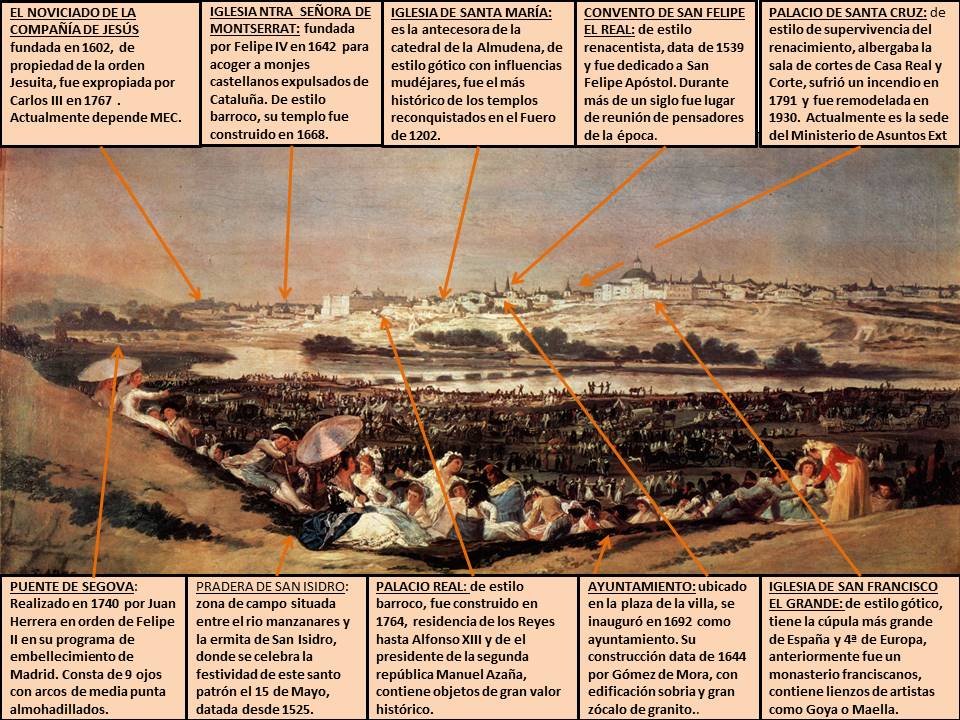
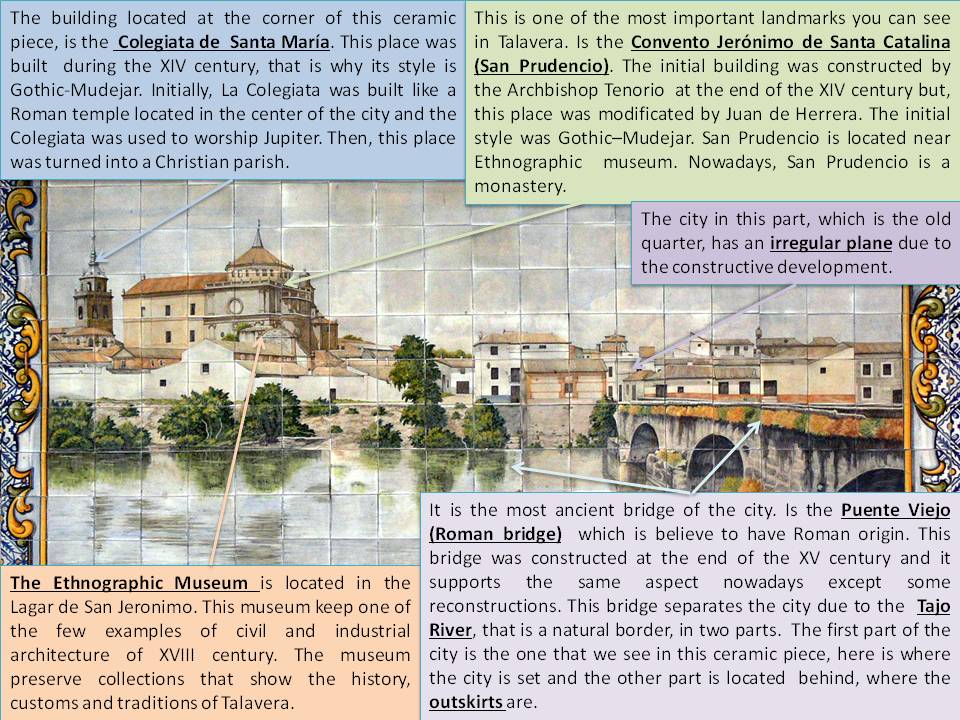
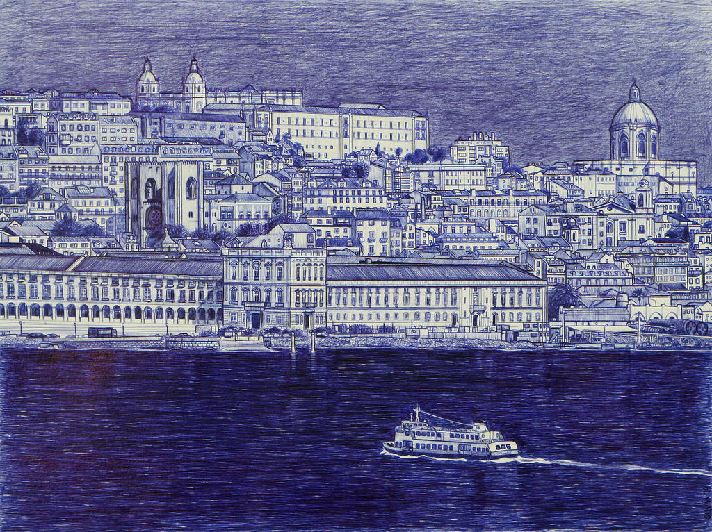
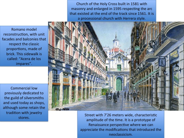
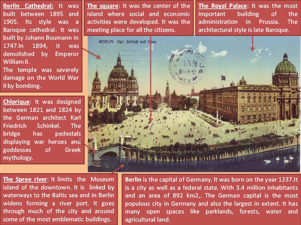
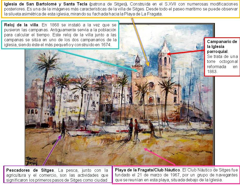
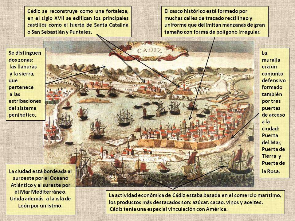
La Pradera de San Isidro es uno de los mejores cuadros sobre la ciudad de Madrid, realizados por Francisco de Goya y Lucientes en 1788. Es un óleo sobre cartón para la fábrica de tapices, de 42 x 91 cm y estilo rococó, que le fue encargado por el rey Carlos III para que decorara las estancias de las infantas en el Palacio del Pardo. A la muerte de Carlos III el encargo quedó en suspenso debido al cambio de gusto del nuevo monarca Carlos IV, que prefería otros palacios. Cuando Goya  terminó el cuadro, éste pasó a la propiedad de los duques de Osuna y en 1986 fue vendido al Estado, siendo trasladado al Museo del Prado, donde permanece en la actualidad.

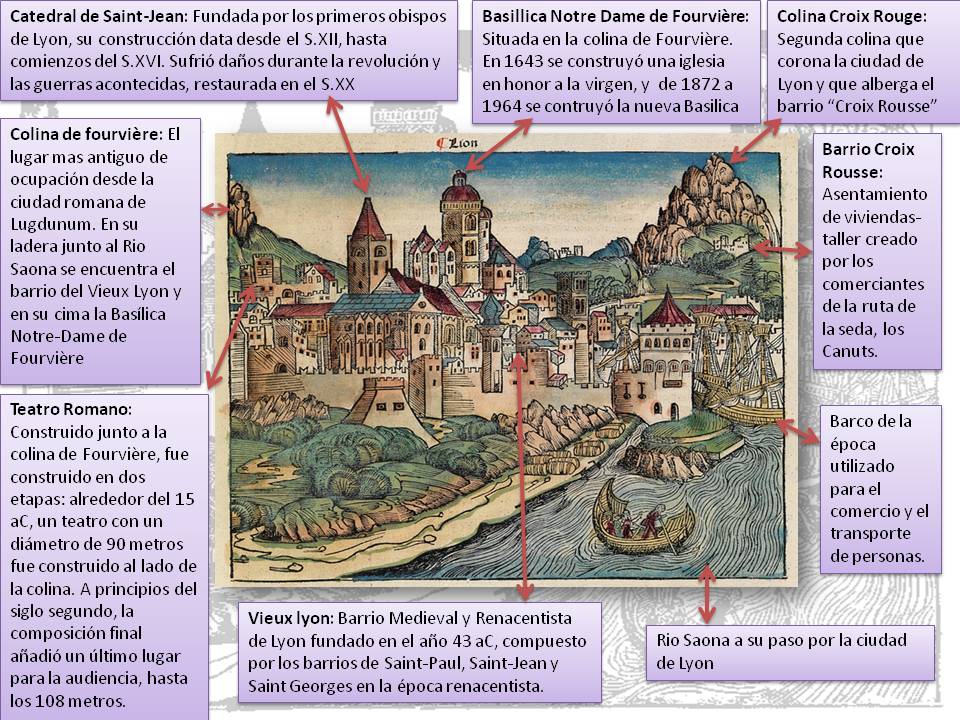
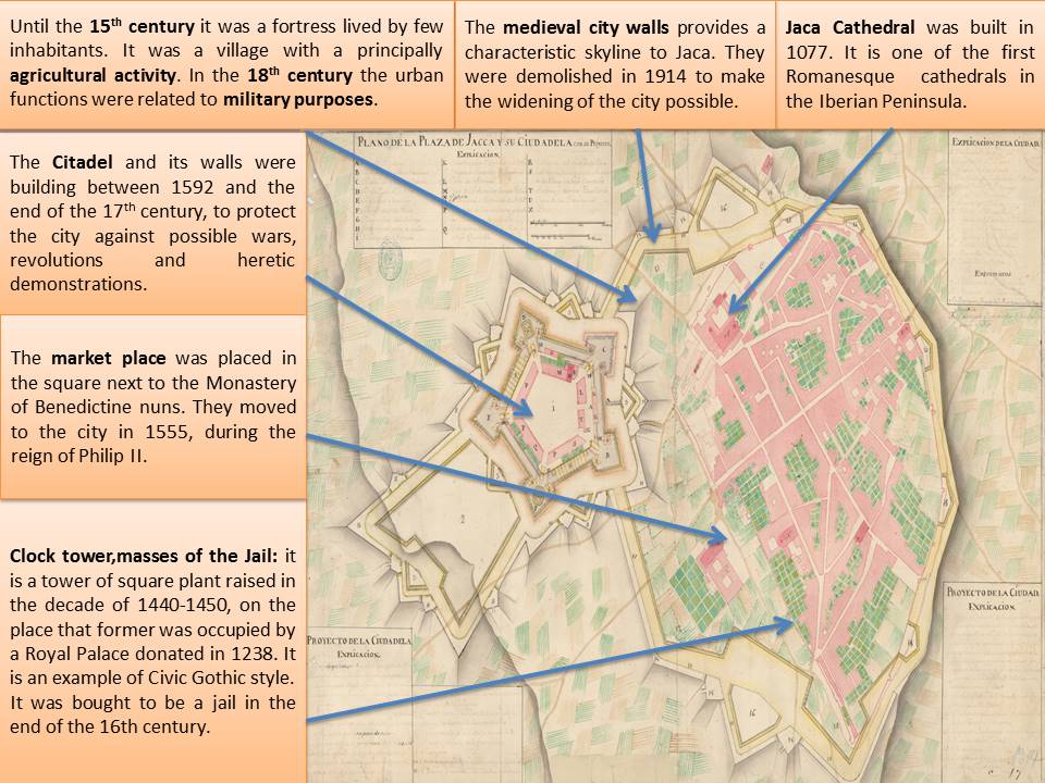
La pintura representa la Pradera de San Isidro, recreando esta zona de Madrid situada entre la ermita de San Isidro y el río Manzanares, con la vista de la ciudad al fondo. En ella se reconocen los principales monumentos de la ciudad, desde el Palacio Real, a la izquierda, hasta la gran cúpula de la iglesia de San Francisco el Grande, a la derecha. La muchedumbre aparece representada durante la festividad del santo labrador, patrono de Madrid, que se celebra el 15 de Mayo.

En este cuadro se pueden apreciar diferentes elementos históricos de la ciudad en el siglo XVIII. Por un lado, en un primer plano tenemos la pradera de San Isidro, donde aparece la gente, el 15 de Mayo de 1788, día de su santo patrón, San Isidro Labrador, cuya ermita, que es donde se venera al santo, está justo a la espalda del punto en el que se sitúa el pintor para hacer el retrato. Por otro lado, y justo delante de la pradera, encontramos el río Manzanares, emblema de la historia de Madrid. Y por último, al fondo, tenemos la vista que obtenemos de la cara suroeste de la ciudad, en la que podemos distinguir los siguientes elementos representativos.

Noviciado de la Compañía de Jesús. Fue fundado el 15 de Abril de 1602, y estuvo considerada como una de las edificaciones más importantes del estilo barroco. Hasta 1601 fue la embajada de Génova en Madrid, hasta que por decisión de Felipe III, se realizó un fugaz traslado de la Corte de Madrid a Valladolid y quedó abandonada. En 1767, los Jesuitas fueron expulsados por orden de Carlos III, siendo cedido por el monarca a la Venerable Congragación de Sacerdotes Misioneros del Salvador del Mundo.

Palacio Real. También llamado Palacio de Oriente, fue proyectado por Filippo Juvara y Juan Bautista Sachetti y construido entre 1738 y 1764. En su solar se localizaba con anterioridad el Real Alcázar de Madrid, hasta que un incendio lo destruyó parcialmente en la Nochebuena de 1734. El Palacio Real Nuevo, de estilo tardobarroco, terminó de construirse en el reinado de Fernando VI. Fue la residencia del rey Carlos III en la fecha del cuadro y el último rey en vivir fue Alfonso XIII, siendo la última persona que vivió allí Manuel Azaña, presidente de la II República. Contiene grandes valores artísticos, como pinturas de artistas como Carvaggio, Velázquez, Goya y frescos de Corrado Giaquinto Tiépolo o Antón Raphael Mengs. También contiene armería real, porcelana, relojería, mobiliario y platería, de alto valor histórico. En la actualidad depende del Ministerio de la Presidencia.

Iglesia de San Francisco el Grande. Es un conjunto conventual que sustituyó al monasterio franciscano medieval. De estilo barroco, fue construido por Francisco de las Cabezas entre 1761 y 1768, que fue relevado por Antonio Polo y por Francisco Sabatini en 1784. En esta Iglesia se exponen colecciones de pinturas de los siglos XVII al XIX. En 1770, Antonio Plá retomó la obra y logró cerrar la cúpula, la cual tiene 33 metros de diámetro, siendo la más grande de España y la cuarta de Europa, por detrás de la Basílica de San Pedro y el panteón de Agripa en Roma y la de Santa María de Fiore en Florencia. Desde 1980 es considerada museo nacional. Con anterioridad a la fecha de realización del cuadro ha sido iglesia, hospital, polvorín, almacén de objetos religiosos, panteón nacional y museo mientras era utilizado de cuartel y prisión militar. Contiene, entre sus riquezas artísticas, lienzos de Goya, Maella, Moreno Carbonero y Ferrant entre otros.

El cuadro nos plasma una de las costumbres más características de la época en Madrid, como son las meriendas y verbenas de la festividad de San Isidro. Es una época en la que la villa de Madrid tenía 156.672 habitantes y en la que tenía trazos de una villa antigua, por la irregularidad de sus calles. La sociedad estaba organizada en estamentos, la persona nacía y crecía dentro de una clase social y no podía ascender, y la clase se basaba en criterios económicos. Se dividían en la Nobleza, el Clero y el tercer estamento o estado, que eran los campesinos, burgueses y clases populares de las ciudades.

Económicamente, se dependía fundamentalmente de la agricultura y la ganadería. También existían grandes señoríos (80%) en manos del Rey, la Iglesia o los grandes señores de la época, siendo los campesinos jornaleros o arrendatarios. Además existían talleres artesanos y comercio local y comarcal con poco desarrollo. Casi todos los aspectos sociales y económicos los regía el Rey Carlos III, la Iglesia y los grandes señores de la época, no teniendo el resto de clases ninguna opinión respecto al funcionamiento del país.

En cuanto a su emplazamiento, el casco antiguo de la ciudad, que es todo lo edificado que se ve en el cuadro, se localiza junto al río Manzanares que a modo de obstáculo determinó que la ciudad se ampliara desde el punto de vista geográfico hacia el Noroeste. Este emplazamiento viene determinado por su desarrollo histórico, que tuvo dos grandes fases:

-Medieval: el casco antiguo surge en este emplazamiento por ser una zona elevada junto al rio. Tiene un plano irregular, debido al crecimiento no planificado, es una ciudad cerrada, limitada por murallas y por la falta de espacio de lugar a calles pequeñas y estrechas. La ciudad surgió también en esta zona, por estar en torno al Palacio Real, antiguo Alcázar, aparecen las calles más importantes desde este punto hasta las puertas de la muralla en forma radial.

– Moderno (siglos XV-XVII): en esta época, su desarrollo y crecimiento está unido a su carácter de capital y las actuaciones urbanísticas de la monarquía absolutista del siglo XVII.

La siguiente modificación de la ciudad se hará con el inicio de la industrialización en el siglo XIX. La población aumenta y se diversifican los usos del suelo, y tiene una importante transformación el casco antiguo. Se remodelan y amplían nuevas calles que facilitan las comunicaciones y se habilitan nuevos espacios para edificar. Desaparecen los recintos amurallados para dar lugar a una expansión planificada de nuevas áreas residenciales (Ensanche). Entre las principales áreas de ensanche, se localizó en la zona este del casco antiguo, llamado distrito de Salamanca (obra del ingeniero Carlos María de Castro), siguiéndole el del distrito de Argüelles-Moncloa (en la zona Norte). Presentaban un trazado regular y ortogonal que facilitaba la parcelación, la venta de terrenos y la organización de la circulación (clave para el desarrollo del transporte y su posterior ampliación urbanística).

El desarrollo en el transporte, permitió la urbanización periférica, siendo el que más destacó la Ciudad Lineal de Arturo Soria (el proyecto se realizó teniendo como eje a una ancha calle central, vía de comunicación, en torno a la misma se debían construir, en parcelas regulares). El desarrollo de la industria, el aumento acelerado de la población y el avance de los transportes provocó un rápido crecimiento del espacio urbano. Surgen otros ensanches, siguiendo las principales vías de comunicación, se extienden, con una planificación cada vez más irregular, hasta englobar núcleos urbanos y rurales ya existentes. Estos pueblos periurbanos presentan planos irregulares, propios de los núcleos preindustriales. Corresponden a esta etapa las zonas del Fuencarral (Norte), Hortaleza (Este), Vallecas ( SE), Carabanchel ( Sur) …

La rapidez de este crecimiento, la necesidad de construir viviendas para la población trabajadora y la especulación darán lugar, a mediados del siglo XX, a un urbanismo desordenado y difuso, que no presentan una calidad ni en el trazado urbano, ni en los equipamientos, ni en las edificaciones. Este nuevo urbanismo se localiza en la periferia y se construyó a partir del enorme crecimiento de la ciudad desde la posguerra. En ella pueden distinguirse diferentes tipos de áreas:

1. Las áreas residenciales son de distinta categoría; antiguos barrios de chabolas, mejorados posteriormente; diversos tipos de poblados de promoción oficial de la década de 1950, con malos materiales y escasos equipamientos, recibieron después remodelaciones y mejoras ( Manoteras, San Blas, entrevías..); barrios de bloques y torres con trama abierta y de diferentes niveles en las décadas de 1950 a 1970 ( Concepción, Aluche..) y urbanizaciones de viviendas unifamiliares de baja densidad a partir de la década de 1970.

2. Las áreas industriales son también de diverso tipo: polígonos industriales relacionados con el desarrollismo de la época, localizados principalmente en el sector sur, junto al río Manzanares y nuevos espacios industriales de mayor calidad (parques industriales y empresariales, en el sector norte y noreste.

3. Las áreas de servicios y equipamientos buscan en la periferia espacios más baratos: centros comerciales, escolares, sanitarios… a partir de la década de 1980.

Sergio Osuna

05/2/15

CHINCHILLA DE MONTEARAGÓN (Juan Fernando Palomino y Oropesa, 1793)

CHINCHILLA La imagen corresponde a un grabado de la ciudad de Chinchilla en el siglo XVI, realizada por el autor Juan Fernando Palomino y de Oropesa en 1793. Palomino fue un grabador calcógrafo español, hijo y discípulo del también grabador, Juan Bernabé Palomino.

La imagen es una  “Vista Oriental de Chinchilla”, según aparece titulada en la estampa, junto con el escudo y clave de la vista en la parte inferior. Esta obra esta sacada de la biblioteca pública del estado, biblioteca de Albacete, es la estampa 6 (recortada) del Tomo I «Reino de Murcia del Atlante Español o Descripción general geográfica, cronológica, é histórica de España, por reinos, y provincias, de sus ciudades, villas y lugares muy famosos,  sacado a la luz  en el siglo XVIII por Don Bernardo Espinalt y García entre los años 1778 y 1795.

En cuanto a la descripción de la imagen, muestra una perspectiva de paisaje con un trazado urbanístico de terreno irregular en lo alto de un cerro y en cuesta. En la parte inferior del   grabado se muestra una leyenda clave de vista bastante legible, donde señala a través de números, los elementos urbanos más importantes. La perspectiva de la panorámica del conjunto urbano manifiesta que fue realizada desde el Cerro de San Cristóbal.

Chinchilla de Monte Aragón es un municipio español de la comunidad de Castilla La Mancha, situado a 15 kilómetros de la capital de Albacete. Desde siempere ha destacado por su situación estratégica, ya que se ubica en un ribazo de cerro macizo y su castillo dominaba la población para poder divisar con precisión los ataques enemigos, en el cabo de la montaña. El lugar destacaba entre las inmensas llanuras albaceteñas por ser el único cerro en kilómetros. La historia cuenta, que por esta razón, hubieron asentamientos en ese lugar desde tiempos anteriores al neolítico.

Chinchilla estaba emplazada sobre un terreno uniforme, construida sobre planos de piedra escarpados y rodeando al conjunto urbano a través de un largo cinturón amurallado irregular en altura, fortificaba la ciudad para proteger sus lienzos, todos ellos de argamasa de cal   custodiados en el castillo, que data del siglo XV y construido por Juan Pacheco, marqués de Villena. Posteriormente la fortaleza, estuvo sujeto a la Corona Real.

El castillo estaba adaptado a la orografía del terreno, era de planta ovalada, se acentuaba en él, su carácter inexpugnable por el enorme foso que lo rodeaba. El foso fue construido artificialmente en la roca con unas dimensiones de diez metros de ancho por seis de profundidad, por lo que estaba considerado un lugar totalmente inaccesible. Estaba construido en piedra, empleándose mampostería en los muros, y sillar en las zonas más representativas donde se han encontrado también restos de murallas godas, árabes, cristianas, también en sus vertientes se han encontrado vestigios arqueológicos de diferentes culturas desde restos ibéricos a restos romanos.

Las remodelaciones fueron ordenadas por el infante Don Juan Manuel, señor y príncipe de Villena. Posteriormente el castillo fue restaurado por el Marqués de Villena, Don juan Pacheco a mediados del siglo XV. Enrique IV adquiere los restos de la fortaleza en 1449, a partir de ahí, se encargó de su remodelación, alzando de nuevo, un importante castillo cuya estructura en cierta medida es la que perdura a día de hoy. Tras la llegada  al trono de Castilla de Isabel I y unificada la península bajo Isabel I y su esposo Fernando de Aragón, el castillo de Chinchilla sirvió de cárcel desde el siglo XVII hasta el siglo XX.

La estructura de la ciudad era militar defensiva y a través de su gran muralla, que tenía un perímetro de 209 metros, con trece torreones circulares, con troneras de cañón cubiertas en sillar y sillarejo, encerraba en sus intramuros casas escavadas en la roca, numerosas edificios en suelo urbano donde se construían casonas, patios y calles en cuesta debido a la topografía del entorno. El casco antiguo fue declarado Histórico – Artístico ya que la estructura y conjunto urbano forman todavía su belleza de trazado medieval

La Plaza Mayor estaba situada en el centro urbano, donde se desarrollaba la vida cotidiana, lindaba con el Ayuntamiento, construido entre los siglos XVI al XVIII y la Iglesia Arciprestal de Santa María del Salvador, la cual ofrece hoy, un curioso estado fruto de sucesión de diferentes estilos: portada gótica, interior barroco y una bella cabecera renacentista.  Entre las obras religiosas de la ciudad se encontraban el convento de Santo Domingo, con su templo mudéjar, el convento de Santa Ana, levantado sobre un conjunto islámico y las numerosas ermitas que poseía, destacaríamos la ermita de San Antón. En la actualidad, algunos de estos edificios se conservan en gran medida.

Por otro lado, en los extramuros de la ciudad, los terrenos eran más áridos, compuestos de suelo rústico, se hallaban casas dispersas, ermitas, cuarteles de milicianos, fuentes y molinos, donde en pequeñas parcelas, los campesinos vivían del campo y del pasto de los animales. Chinchilla se convierte en un enclave y núcleo lanero muy significativo en las cañadas del sureste por la ganadería y la exportación a Oriente de sus telares, tejidos y alfombras.

En 1422 Juan II concede a Chinchilla el titulo de ciudad, haciéndose  así, nexo de comunicaciones y parada obligatoria de caminantes y emporio de comercio. Durante muchos años fue escenario de guerras, desde la Guerra de Sucesión en 1707, pasando por la Guerra de la independencia que también se adueñaron los franceses y destruyeron una de las torres del castillo, (el Torreón del Homenaje).

En la actualidad todavía se conservan restos evidentes de la antigua muralla, que fortificaba la ciudad englobando el conjunto urbano, con edificios parcialmente conservados como la Plaza mayor, el edificio de la concejalía, el castillo y sobre todo la iglesia de Santa maría de Salvador. La ciudad sigue ofreciendo ambiente medieval, también conserva tramos de origen árabe.

La actividad socioeconómica ha ido creciendo por sus  gran expansión industrial y el uso de sus molinos, en la actualidad apuesta por el desarrollo sostenible dando así un incremento y una visión de futuro a la situación ambiental, económica y social del municipio. Por su ubicación estratégica, por su comercio y por la importancia histórica que ha llevado, Chinchilla, fue por mucho tiempo la capital de la Mancha de Aragón.

Juan Miguel Moreno Fernández

05/1/15

BADAJOZ (Atlas Massé, Siglo XVIII)

2GEO-blog-marcos-jiménez

La imagen corresponde a un plano geométrico de la ciudad de Badajoz y es de autor desconocido, aunque se sabe que fue realizada por algún ingeniero francés. Pertenece a la época histórica de comienzos del siglo XVIII y está recogida en el Atlas Massé (AG) publicado por A. Bonet Correa en 1991.

Ya en la Edad de Bronce aparecen inidicios de un núcleo de población que luego se identificará con la ciudad de Badajoz.  También en la época romana hay vestigios de algunas villas rurales en la zona.  Cuando llegan los visigodos, Badajoz ya era una ciudad fundada como tal, pero no es hasta el siglo X cuando tomará importancia como núcleo urbano, convirtiéndose en capital de un reino de Taifa poco más de un siglo después. Hay textos árabes que indican que su fundador fue Ibn Marwan en 875, y que el lugar que eligió para el asentamiento estaría situado en el fuerte de San Cristóbal. El 19 de marzo de 1230, Alfonso IX de León, conquistó la ciudad al rey musulmán Abenhut. Las guerras civiles castellanas en el siglo XIII y XIV marcaron la vida  de esta ciudad durante la Edad Media. En el desarrollo de Badajoz ha sido determinante su localización geográfica, por su proximidad a la frontera con Portugal, sobre todo con el Alentejo, lo que le convirtió en escenario de numerosos enfrentamientos.

En la imagen se distinguen distintos elementos urbanos como el fuerte de San Cristóbal y el fuerte de la Cabeza del Puente, que se construyen al otro lado del río Guadiana. Desde este último fuerte, sale en Puente de Palmas, que comunica con las murallas de la ciudad. En el siglo XVII, se amplía la zona amurallada siguiendo el sistema creado por un ingeniero militar francés llamado Vauban. El Hornabeque o fuerte de Pardaleras se sitúa entre el cuarto y el quinto baluarte de la muralla. Dentro de la misma se encuentra el casco antiguo separado del viejo castillo o Alcazaba por una estrecha muralla. Los elementos naturales son el río Guadiana y el río Rovilas.

La estructura y el trazado urbano de Badajoz son irregulares y tienen carácter fronterizo y militar. Esto se advierte en el aspecto defensivo de su recinto amurallado, además de haber sido destacamento militar, sobre todo en los siglos XVIII y XIX, estando su espacio urbanístico ocupado por cuarteles y dependencias militares. El Catastro de Ensenada recogía información sobre la población activa, e incluso nos detallaba que el oficio público más numeroso era el de regidores y el oficio privado más numeroso era el de jornaleros.

La población de Badajoz llegó a vivir intramuros hasta el primer tercio de siglo XX. Con el tiempo, esta ciudad dependiente del río Guadiana se ha convertido en punto de encuentro con Portugal. Gracias a su vida universitaria y al crecimiento de la ciudad, ha llegado a ser el lugar más poblado de toda la región de Extremadura. Su gran patrimonio cultural e histórico-artístico hacen que Badajoz sea a día de hoy una ciudad cosmopolita.

Marcos Jiménez Cristóbal

05/1/15

TALAVERA DE LA REINA (Edgar T. A. Wigram, 1906)

1GEO-blog-valls-montealegre

Esta acuarela representa Talavera de la Reina vista desde la orilla derecha del Río Tajo, la misma en la que se sitúa la ciudad, con orientación oeste. Está realizada en los primeros años del siglo XX por el acuarelista Sir Edgar Wigram, 6º barón de Wigram, (1864-1935) y forma parte de su libro de paisajes “Northern Spain, Painted and Described”, que realizó durante un viaje por el Noroeste y centro de España en bicicleta.

Se puede apreciar en la imagen el margen derecho del Tajo con el Puente Viejo, que tiene las bases de los pilares de origen Romano y al ser un paso principal para poder cruzar el río, situó a la ciudad como un centro de comunicaciones importante. Se aprecian también las siluetas de dos importantes edificios religiosos, el Monasterio de los Jerónimos y la Colegial de Santa María la Mayor, que se sitúa en la Plaza del Pan, principal plaza de la ciudad que hace las veces de plaza mayor y centro administrativo donde se encuentra la sede del ayuntamiento. En la imagen podemos ver también el campanario de la Iglesia del Salvador, donde, tras la reconquista de la ciudad, el alcalde castellano administraba justicia. En la misma época, al haber dos alcaldes, era la Colegial donde el regidor mozárabe hacía lo correspondiente con su población.

Talavera se encuentra situada en la zona Oeste de la provincia de Toledo, en el margen derecho del Tajo a unos 5 km. al Oeste de la desembocadura del Río Alberche. El origen de la ciudad es prerromano, pero es en época romana cuando se consolida como centro urbano con el nombre de Caesarobriga. En ese período se construyó el templo dedicado a la Diosa Ceres, que posteriormente en el año 602 se convirtió en la Ermita de Nuestra Señora del Prado al cristianizarse con la Virgen del Prado (Patrona de la Ciudad), que fue un regalo del Rey Visigodo Liuva II como parte de la cristianización de toda la península, transformando la festividad pagana de tributo a la Diosa Ceres en una ofrenda Católica a la Virgen del Prado, las actuales fiestas de las Mondas. La que fuera Ermita en aquella época, ya que actualmente ha pasado a ser Basílica, alberga una importantísima muestra de cerámicas que hacen que sea comúnmente llamada la “Capilla Sixtina de la Cerámica”.

En los años en los que fue pintada la acuarela, Talavera de la Reina era la 2ª ciudad más poblada de la provincia de Toledo con aproximadamente 11.000 habitantes y la 12ª de Castilla la Mancha. Actualmente, debido al desarrollo de las comunicaciones, la industria y el comercio, es la ciudad más poblada de la provincia y la segunda de Castilla la Mancha. Los primeros años del siglo XX fueron en los que la ciudad empezó a crecer en importancia y tamaño debido a la apertura de uno de los primeros tramos de ferrocarril en España, que llegó a Talavera en 1876 y la comunicaría con Madrid y Portugal, aumentando el volumen de comercio de los productos agrícolas y ganaderos de toda la comarca.

En esa época empezó a resurgir también, de manos de Juan Ruiz de Luna, la cerámica; retomando la tradición que dio fama e identidad a la ciudad en los siglos XVI-XVII, que debido al período de crisis previo se había abandonado. Gracias a la aportación de este artesano, la ciudad sigue manteniendo esa seña de identidad y se puede seguir admirando su obra en el museo que lleva su nombre.

La organización de la ciudad, debido al aumento tan grande de población en esas fechas y que existían dos barreras físicas complicadas de salvar (el río al sur y la vía del tren al norte) hacen que la ciudad se expanda de Este a Oeste y se edifica sin mucha planificación urbanística. Esta situación dio como resultado un caos urbanístico, además de la destrucción de buena parte del patrimonio. Debido a que la ciudad aumenta solamente en el eje este-oeste, se vertebra con grandes avenidas para comunicar sus extremos, en los que se encuentran por el lado este las nuevas zonas residenciales y en el extremo oeste la zona industrial con los polígonos.

Enrique Valls Montealegre

04/30/15

VEJER DE LA FRONTERA ( Retamero Sanchez, 2014)

vejer

This work belongs to a collection of personal paintings of Retamero Sánchez. It is a painting of a small town in the province of Cadiz, South of Spain, called Vejer de la Frontera, wich is near other towns like Conil de la Frontera, Zahara de Los Atunes and Chiclana de la Frontera. The painting was taken from the website retart.es and it was made 2014. Retamero Sánchez is a Spanish painter born in Jerez de la Frontera (Cádiz). He is a self-taught painter with over thirty years of experience, classified as impressionist figurative although his trends are constantly evolving, but always staying true to a personal style. We can appreciate that the author has used the style of oil painting, as he does in  most of his paintings. He wants to show us how a typical Andalousian town looks like, the magic of a town with all the houses painted in white and how the sun shines in its making. As we can see, the town is at the top of a mountain so we can distinguish the rich flora with beautiful coloured plants and trees.

Vejer de la Frontera was conquered by the Arabs in 711 and was under their rule for five and a half centuries. The Arabs imposed their religion, customs and  buildings and gave to this town a very peculiar appearance. All the buildings are painted in white as in every Andalusian village to soak the heat and not to be so warm indoors.

We can see that Vejer is located at the top of a mountain in order to be very well defended. As a legacy of the Arab people we can see that there are narrow, winding streets, courtyards all very tight and no order, so we can say that is a style of popular Arab-Andalusian architecture. Also, we can find like in most of the Arab style towns, that the central area is the most important one. In the past there were a  mosque and a palace but now there are a parish church and a castle. The Castle of Vejer was declared a National Monument in 1931, and the parish church of Divino Salvador is the second tallest building. We can also see  the Torre de Buenavista and the Torre de la Corredera.

Finally, there are a number of gates to get into the city, and some principal streets to facilitate communication between the center and the outskirts. Nowadays the Vejer has two different parts, the one on the top of the mountain and the one at the one by the beach. As economic activities today predominates tourism, trade and fishing.

Sergio Martínez Chozas

04/30/15

LISBON (Carlos Galvao, 2014)

geo-presentation-definitiva2

This painting is a work by Carlos Galvao, a Portuguese artist who is an expert in oil and acrylics on canvas. This painting was done in 2014, and it is downloadedfrom the artist’s website. It portrays with great details an aerial view of the city of Lisbon. It shows one of the banks of the river Tajo, where we can see the famous Market Square, known for being the most important square of Lisbon.

Lisbon is the largest city and the capital of Portugal. It is located at the mouth of the Tajo River. The city has a population of 547,773 habitants and is the richest of the country. It is located in West Portugal, facing the Atlantic Ocean, and is one of the warmest European capitals. The spring and summer are usually sunny with highs around 28°C during July and August and minimum of about 16°C in Autumn. Thw winters are typically rainy and windy, with some sunny days. The climate of Lisbon is strongly influenced by the Gulf Stream so the temperatures are milder with abundant rainfall.

The place represented in the painting has always been the best entrance to Lisbon. Many kings and important people arrived there by boat, got down from their ships and went in the city by the marble stairs that we can still see in the square rim. Another thing that I consider important is the earthquake that Lisbon suffered in 1775 and claimed the lives of between 60,000 and 100,000 people. The city was almost completely destroyed and many buildings were reconstructed, including the Market Square.

We can appreciate in the painting a boat as a way of transportation and crossing the river but there are also two bridges: the Bridge of April 25, and the bridge Vasco de Gama. For the inside Lisbon has five tram lines, four of which have antique look so they attract many tourists. We can also highlight several religious buildings such as the church of Santa Luzia, the monastery of St Vincent de Fora and Lisbon Cathedral, all of them with great importance.

Finally, on the right of the picture, we can see the most impressive building in this drawing, the National Pantheon, also known as the Church of Santa Engracia. Since the early 20th century, this building served as a burial place for famous and important people from Portugal. The most remarkable fact is the architecture of the Pantheon is its large white dome, which stands majestically between the roofs of Alfama and can be seen from some of the viewpoints of the district, as the Mirador de Santa Lucía.

María del Carmen Lázaro Álvarez

04/30/15

TENOCHTITLAN (Antoine du Pinet, 1564)

final blog pp

This work of art belongs to an atlas called Civitates Orbis Terrarum, by Georg Braun and Franz Hogenberg. This atlas contains more than 500 maps of cities of the world. This woodcut represents the city of Tenochtitlán, which is the capital of the Aztec Empire (nowadays Mexico City). It was made by the cartographer Antoine du Pinet (1564) but thanks to the help of the engraver Francesco Valesio, who illustrated the work of A. Pinet. The image is based on a map included in a letter by Hernán Cortés that was written in 1524.

We might say that Mexico-Tenochtitlán was located in the Cuenca of Mexico, between the 2,270 and 2,750 meters on the sea level, in the southern part of the Mexican Plateau. The foundation of Tenochtitlán is not very clear because myth and reality mix up but it is dated more or less in 1325. The word Tenochtitlán is the leeway of the words tetl (stone) and nochtli (prickly pear); the stone where the tunal is placed means «Heart of the Earth”, for the form in which it is represented.

The city was originated in an islet of the Texcoco Lake. Texcoco was part of a system of lakes, at present in disappearance process, located to the south-west of the Valley  of Mexico. During the Aztec Empire, they constructed artificial islands in the shallows of the lagoon, with the intention of building up towns. These islands were extended artificially up to including Tenochtitlán itself and the twin city of Tlatelolco. Tenochtitlán was not located in the center of the Lake Texcoco, but in a sort of bay in the South-Western angle of the same one. It is curious to note that although the lake of Texcoco was salted, the city was surrounded with fresh water thanks to the dykes constructed by the Mexicas that allowed to concentrate the river water that fed the lake. The city disappeared when the Spanish conquest, after a siege organized by Hernán Cortés in 1521, and then it was constructed the new Mexico City.

The image clearly shows us a great example of radio-centric town planning with the axis in the ceremonial center of the sacred enclosure. From that point onwards, the metropolis was expanded following a concentric form according to how the different social classes were related to that religious center. In the surrounding areas of the sacred enclosure the housings of the noblemen were getting up, also the managers and craftsmen and, in the periphery, a rural population. The city was plenty of small canals that acted as real streets and this is why it was called «the American Venice». Another curious thing was that the «symmetry» of the city was maintained by means of an official called calmimilócatl, which had to supervise any construction and prevent from being invaded the streets and channels, which were constructed previously.

It is known that in the ceremonial center there were 78 buildings, of which, today it is known the Great Temple and some buildings more that sublie under the current Cathedral. The whole ceremonial center was surrounded by a wall called coatepantli, which was decorated with figures of snakes and was measuring approximately 2,5 meters high. The Great Temple was the biggest building inside the sacred enclosure. At the top of the Temple, there were also two ritual templetes for the sacrifices: one dedicated to Tláloc and other to God of the Sun. This sacred enclosure was placed in the center of Tenochtitlán and as we can see and was connected with all the parts of the city by four main strees. In addition, there were three main roadways that connected the city center with the outskirts.

In relation to the ecomical activities, the basin of Mexico offered a large amount of natural resources. The Aztecs supplied the city by means of an intensive farming with cropfiels and chinanpas (floating cultivation in marshes and shores of the islets). The most important cultivations were based on corn vegetables and flowers. They also fish a great variety of species (fish, birds, axolotles, frogs, freshwater shrimps) and hunted terrestrial fauna (rabbits, deer). The instruments to work these grounds were simple: they only used  the coa (stick used for the farming) that was expanding in hoe. The commerce was in charge of the pochetcas (businessmen) that, in spite of its high social level, were not remaining exempt from paying tax. Generally, the commerce was done by exchanging goods, equivalents in value, or by means of currency, which was represented by grains of cocoa or beans. This class of commerce, favored the product exchange, and therefore Tenochtitlán developed as a very important market city.

Pedro Guzmán Gil

04/29/15

SANTO DOMINGO (John Ogilby, 1671)

1GEOB-Moreno-Lator

This image is a not drawn to scale perspective map of Santo Domingo city. It was made in 1671 by John Ogilby, a Scottish cartographer and translator who lived in London during the 17th century. The map was included in Ogilby’s work called America: Being the Latest, and Most Accurate Description of the New World, which was an expanded and hand coloured translation based on a book published in Amsterdam by Arnoldus Montanus. This draw is an antique map part of a group of volumes characteristic of sixteenth and seventeenth centuries where text, maps and illustrations about the European colorizations were joined.

This bird’s eye view shows the first European city founded in the New World in the 15th century on the southeastern coast of the island of Hispaniola, on the Caribbean Sea. As it appears in the map, the proximity to the sea and the river facilitated the protection of the city. While the sharp cliffs created a natural defence, the river meant the water supply and thus the existence of crops and other tropical plantations that can be appreciated in the bottom right part of the image. Furthermore the river mouth provided a natural sheltered port.

This city was firstly founded by Bartholomew Columbus in 1496 on the right bank of the Ozama River and then, after being destroyed by a hurricane, it moved to its current location on the left bank in 1502. The first building, which construction was initiated by the Governor Nicolás de Ovando to protect the city against corsairs and pirates, was the Ozama fortress. From then, the whole city was edified surrounded by a fortified perimeter with city walls, towers and a moat that provides it with the appearance of a defensive city as the map depicts.

Concerning the town planning, Santo Domingo was built up during the first half of the 16th century following an orthogonal plan with a well-structured street layout and many parks and green areas, serving as an essential point of reference for the construction of the Colonial grid cities. On the left margin, the map highlights the defence wall with the main entrances that lead into the principal roads such as the Royal Coast Road which connected Santo Domingo with San Iago and Azua. In addition, on the background, the “Casa Consistorial” or the “Cabildo” stands out from the rest of the constructions because of its size, so it could mean that it had an important function on the city life as it was the town council.

During colonial times and even now, Ozama’s port has been really important for the city’s economic development, becoming the centre of economic activities in the Dominican Republic. Besides, the trading activity had made this port the busiest port in the country over time. The port facilitated trades, and it was the point from where many colonization expeditions headed by famous explorers such as Ponce de León, Vasco Núñez de Balboa or Hernán Cortés were launched. The city was favoured and enriched because of both foreign and internal trade and so many explorers owned a house, as Hernán Cortés’ house that appears in the map, and created jobs for the indigenous people that still inhabited the region. It is important to mention, that the good location of the city and the port facilities not only provided satisfactions since it led into frequent assaults, loots and pillages. The most known attack was carried by an English corsair called Francis Drake who devastated and destroyed the city for ransom. Despite this, Santo Domingo has been always a trade city in which cultural, economic and religious activities took place.

Clara Moreno Lator

04/29/15

MÁLAGA (Anton Van den Wyngaerde, 1564)

Diapositiva1

Anton Van den Wyngaerde is the author of this image. He was considered the most famous topographer in the Rennaissance, because his most important aim was the cartographic precision of the landscape representation. During the sixteenth century, he made several paintings of some relevant cities in Spain, commited by King Phillip II, who wanted an exact and complete description of the geography of Spain.

Málaga is the city that we are going to study. It is situated in the south of Spain and particularly located between the sea and the mountains. These two factors influenced a lot in its development. The image represents a panoramic perspective from the sea focusing on the fleet of García de Toledo and the city in the background. It is possible to distinguish the landscape from the Castle of Gifralfaro to the proximal village of Torremolinos. In those times, Málaga had a population of around 15.000 inhabitants and was a very important commercial city.

Gifralfaro Castle is placed at the top of a hill in the right margin. It was built by Caliph Abderramán III and in 1340 the Nasrid king Yusuf I remodelled and transformed it in a luxurious castle. After that, the Catholic Monarchs used it to take it as their vacation residence. The origin of this construction is primarily a refuge for the troops and also to protect the Alcazaba as it had a better view of the city and the sea. Further down we can see the Alcazaba or fortress. This area is connected to the rest of the city by two roads, one along the hill which has a battlement and another road going to the sea. The fortress was formerly a Phoenician building but then reconstructed with limestone by the bereber king of Granada, Badis ben Habús. After that work, its function was aimed to be rather defensive and it was the residence of Governor and knights.

Apart from that, Málaga had with a big city wall to protect itself from any danger. This wall had a Phoenician origin although it was rebuilt several times. It went across the coast from the Gibralfaro castle to the other side of the city. Moreover, the city wall had a number of sea gates with the aim of getting the materials from the commercial ships easily. Not only the battlement, but also watchtowers which were made in sixteenth century, can be seen in the picture. Their purpose was the defence of the territory against the attacks of Moorish pirates. 

Other important elements and characteristic parts of the city are displayed such as the  or fortress. Apart from that, the author of the painting wanted to show us the urban skyline, formed by the city wall and many religious buildings such as churches, convents and the cathedral.  Among the religious buildings that we can appreciate in the picture we can mention the Mártires Church, made in Moorish-Gothic style. It is located on the city centre and it was originally built by Catholic Monarchs. In addition, we can see the church of San Juan situated on the left, whose style is the same as the previous one, as it was built in the same era with pointed arches on pillars and a tower that was finally completed in the year 1543.

To finish with, in the painting by Anton Van den Wyngaerde, we can see an Arab spring, but it was not until 1586 that a better and modern one was built. This caused a mayor delay in the commercial development of Málaga, because before that it was so difficult to embark on that área. Wyngaerde also portrayed the urban structure by showing the different parts of the city, from the center to the outskirts. This is why the painting was made in 1564 and is considered a very important graphical document for knowing the historical, economic and social evolution of Málaga.

Paula Martínez Rueda

04/29/15

ZARAGOZA (Joan Soler, 20th century)

Zaragoza

This painting represents the city of Zaragoza in the late 20th century in Spain, by Joan Soler, a modern painter from Mallorca. The image belongs to a private collection. This type of image is called “Zenith” and it means that the place from where we can see the city in the picture is taken from the top to the bottom, thus, the perspective seems that the subject is situated perpendicular to the ground.

Zaragoza is a very big and important city in the north of Spain. It is the capital of Aragon region and is very well-known because of the Basilica of Pilar and other significant monuments. The image portrays a lot of differences between the old quarter and the new part of the city. The left part of the city, to the other side of the river Ebro, started to be constructed in the last decades of the 20th century and became a new neighborhood with a large quantity of people living there.

Zaragoza is a place influenced by many cultures so you can notice some differences within the city. It has the characteristics of a Roman city, so the two most important elements were the cardus and decumanus avenues, two streets that crossed the city from the North to the South and from the West to the East. However, in the medieval age a big city wall was built and the urban layout changed a little bit, becoming more irregular. As we can see in the picture the two elements that they used to connect the city centre with the suburbs were two bridges. Those bridges were too important because they were the main way to join the different parts of the city to the outskirst and the cropfields. In the first place we can see the “Stone Bridge” that today keeps its original name; in the second place we can see the “Tables Bridge” that now is called “Puente del Pilar”.

The street that can be seen in the center of the image is the Echegaray y Caballero Street. In this place you can see the back part of the basilica, which is the most important part for the painter. However, the square that appears in the foreground alongside with the river, looks like the main element for him and also for a great number of citizens. These elements are those that appear more detailed, so it makes us think that the painter wants to stand them out. It is curious because the place where the Basillica of Pilar is settled was the same where it is supposed that the Virgin Mary appeared. At first they had told to build a small chapel but in the Baroque era they constructed this major temple. It is also said that our lady of the Pillar save Zaragoza in the second world war when the enemies army throw away three bombs, that nowadays are on the wall of the cathedral, because they were found at the floor without exploding.

In the end of the 19th century it had become clear for the different town halls of Zaragoza that were necessary a few deep changes in the city to give content to the immigrants of the rural exodus and to adapt the city to the new economic and social realities, this new area was called Ensanche. As in other Spanish cities, the town hall planned the tracing of a «New Zaragoza «, out of the historical center with new buildings and wide and regular streets. It was expected that the citizens from Zaragoza would go progressively leaving the old Zaragoza and they would be established in the newest and best housings. The problem of the Ensanche is that they did not take into account the social reality of that Spain, most of the population was very poor and was not having incomes to be able to buy or rent the new housings. That is why these people went to live to buildings of worse conditions and in slums removed from the center and with scanty services, whereas the Ensanche was a place where the social groups with a higher level of incomes fixed their residences.

The workers were mainly dedicated to the secondary and tertiary sector. In the 20th century, they develop industries as the metallurgy, food industry, electrical production and chemical industry. Besides this, there were important sugar factories and as modern services, the railway industry. Zaragoza was placed in a strategic location, which makes the railway to have much more relevance from the 19th century on.

Cristina Magallón López

04/29/15

RIGA (Thomas Kinkade, 2004)

Diapositiva1

Sunset over Riga is a painting on canvas representing the sunset over the ancient and medieval city of Riga, capital of Latvia, in 2004. Riga is the largest city of the Baltic States and its historical centre is a UNESCO World Heritage Site, remarked for its Art Nouveau architecture and the 19th century wooden architecture.  The painter of this work of art is Thomas Kinkade (1958-2012), an American painter of popular realistic, bucolic, and idyllic subjects and he characterized himself as «Thomas Kinkade, Painter of Light». In addition, it is a painting of “Plein Air” style, what means that the painter reproduces the actual visual conditions that he sees at the time of the painting. Besides, this work of art cannot be visited in any museum, but it belongs to the Thomas Kinkade Company collection and it is available for being purchased through his official website.

In the image we can appreciate part of the urban layout of the city, and therefore we can see an irregular urban pattern due to the amount of narrow streets interlaced between themselves and the agglomerated buildings that form a maze network of alleys. Probably, some centuries before it has a cathedral morphology that reminds us how medieval cities were during the Middle Ages. In addition, the medieval walls were demolished in the mid nineteenth century and later, were replaced by a high amount of boulevards and public gardens that surround most of the old city, as we can observe at the bottom of the image. Besides, the city of Riga lies on the banks of the Daugava River. In the background we can observe some important landmarks of the city extending to the horizon during the sunset.

Besides, Riga’s key economic activities were fishing, animal husbandry, and trading, and later developing crafts in bone, wood, amber, and iron. Nowadays, Riga is one of main economic and financial centers of the Baltic States and the biggest exporter of wood products, pharmaceuticals and metallurgy. Besides, Riga’s Port is one of the biggest in the Baltic States, and lots of commercial ships leave from the Daugava River, an arm of the Baltic Sea, as we can see at the bottom of the image. In addition, tourism is also a large industry in Riga, due to the numerous landmarks that can be seen in the background of the painting and because the Riga historical center was recognized as a UNESCO World Heritage Site in 1997.

Regarding the more relevant buildings, firstly on the left side of the painting we found the Riga Cathedral, which is an Evangelical Lutheran cathedral and the seat of the Archbishop of Riga. Besides, it was built in 1211 and is considered the largest medieval church in the Baltic States. Furthermore, it was subjected to several additions and renovations in the late Middle Ages and the modern era, as a result there is a mix of Romanesque, Gothic, Baroque and Neoclassical elements that can be seen nowadays in the Riga historical center. In addition, the Museum of the History of Riga and Navigation which is housed by the Riga Dome Cathedral, is the oldest public museum in Latvia and the Baltic, dated in the 18th century and is one of the oldest in Europe. Nowadays, it has the largest collection of material evidence of the history of Riga. Next to them, we can appreciate the Riga Technical University dated in 1862 which was the first multi-discipline technical tertiary education establishment in the Russian Empire.

Furthermore, more or less in the centre of the image, it is located the St. Peter’s Church, which is a Lutheran church dedicated to Saint Peter and the first document that talks about it is dated in 1209. The history of the church can be divided into three distinct periods: two associated with Gothic and Romanesque building styles, the third with the early Baroque period. Behind of it, we can distinguish the St. John’s Church, which is a parish church of the Evangelical Lutheran Church of Latvia. The church is dedicated to St John the Baptist and contains several art works related to the saint, including a large painting and a stained glass window representing the saint. In front of St. Peter’s Church, it is situated the House of the Blackheads which was built in 1334, as a meeting and celebration venue for different social organizations. In the 17th century, its only occupants were the Blackheads’ Society and the portal engraving fulfilled: “Should you ever see me falling – raise me up, it’s your calling!”

On the one hand, in front of this last landmark it is placed the Museum of the Occupation of Latvia, which was built in 1971 to celebrate what would have been the 100th birthday of Lenin. It worked as the Museum of Red Latvian Riflemen until 1991. Later, in 1993 it was used to show artifacts, archive documents, and educate the public about the occupations in Latvia by the USSR in 1940, then by Nazi Germany in 1941, and then again by the USSR in 1944. On the other hand, on the right side of the image, we can find the Riga Central Market whose construction was finished in 1930 and in which some Nouveau architectural elements as well as pre-war neoclassical effects were used in the market project. In addition, Art Deco elements are used in some facades.

Finally, in the foreground we can appreciate the Stone Bridge that crosses the Daugava River. In one of the banks of the river we can perceive the Old Riga and in the other one an opened space formed by boulevards and parks along which the people walk. In this way, the bridge project was designed by the engineer G. Popov. Its inauguration was in 1957 and it was named Pont October, but later in 1992 it was renamed as the Stone Bridge. In addition, the Daugava River is a river rising in the Valdai Hills located in Russia, flowing through Russia, Belarus, and Latvia, draining into the Gulf of Riga in Latvia. The total length of the river is 1,020 km and forms part of the international border between Latvia and Belarus.

To conclude, as I have said before, I want to emphasize that the historical center of the city was declared a UNESCO World Heritage Site in 1997, thanks to its Art nouveau buildings and to the fusion of architectural styles, where there coexist towers of churches of the Middle Ages, monuments and wooden architecture of the 19th century and a marked structural Soviet rationalism. Besides, Riga was the European Capital of Culture during 2014, along with Umeå in Sweden and organized more than 200 cultural events. As a remarkable fact, we can highlight that some important monuments turned into rubble during the II World War and that the city of Riga suffered a fire in 1209 which severely damage some relevant landmarks. Interestingly, finally, we can point out that tourists called Riga as «Paris of the East» due to the amount of tourist attractions and cafes on the sidewalks.

Alba Ramos Pulido

04/29/15

PORTO (Udane Juaristi, 2010)

Diapositiva1

This picture represents the tram of Porto. It is made with pencil on wood in 2010 by Udane Juaristi (Azkoitia, 1985). She is a painter who is licensed in Fine Arts specializing in painting and studies in l´École Nationale de Beaux Arts of Paris. This picture is part of a collection entitled “cars and trams” and has been exposed in many cities of Spain, above all in the Basque Country. The picture is not dated, but we can know that is a modern painting according to the style of the cars and the clothing of the people. We can see as the principal element the tram, specifically the number 22, what has allowed us to know the area of the city. The picture was taken near St Catarina Street, that is the main shopping area of the city; this is pedestrian street and is located at the top of the city. As a curiosity in the picture we can see some seagulls because in Porto there is a big colony of urban seagulls.

Porto is one of the most important cities in Portugal, although it is not a very big city (237.559 habitants). It was founded in 1123 and it is situated in the North of Portugal, on the right bank of the Duero river. Actually, Porto has centralized its urban structure around the Duero river. Apart from this center the city has many slopes, caused by the difference in height between the Duero river and the highest points of the city which is around 75 meters. As many other European cities, Porto is an old town with a wide historical heritage, but in recent decades has undergone an extensive modernization. It has the longest subway netweork in Portugal to cover the whole metropolitan area, from the city center to outskirst. Also, the Sá Carneiro International Airport has recently been expanded to a capacity of 16 million passengers a year.

In Porto, old trams have been restored and only three lines are working nowadays. The line 22 circulates between the Carso area and the area of Batalha, where the Batalha Square and São João theatre are, and it also passes along the Avenue of the Allies and very near of Santa Catarina street.

In the 19th century Porto had an economic and political decline in the city with only some service activities, such as shipping and maritime trade. But in the decade of 1890 and the beginning of the 20th century the port of Leixoes boosted an economic growth in Porto coinciding with industrialization and the arrival of the Republic. A symbol of this era is the construction of the Avenue of the Allies. The urban space of Porto started to be developed in the late 19th century. A new Central Business District was created and an intense process of functions specialization was set on each urban area. The constructions made in the early 20th century broke with the traditional ambience of the city and consolidated modernity. The railway station of São Bento was an example of new communications in Porto, that converge several roads and railway lines, which also contributed to turn the city into the main shopping center in the Northern region of Portugal. Despite the progressive outsourcing center, industrial activity continues to be of great importance to the work in its industrial belt full of factories for textiles, footwear, furniture, ceramics, metalwork, jewelry and other manufacturing activities, some also craft.

In 1919, as a response of the Lisbon attempt of independence, conducted by Paiva Couceiros, Porto became tentatively capital of Northern Portugal. The immediate Republican reaction ended the uprising. The Salazar dictatorship, which lasted until the Carnation Revolution of 1974, much improved infrastructure, highlighting the construction Porto Arrábida Bridge in 1963. In 2001 Porto was, next to Rotterdam, cultural capital of Europe and, for such an event, the striking auditorium «Casa da Música» was built in Boavista, symbol of the capital. Today Porto, economically speaking, is lagging behind Lisbon, while still maintaining its reputation for working, open and welcoming city.

César Martín López

04/29/15

ATHENS (Michel Delacroix, 1994)

ATHENS

This work of art represents the arrival of the US Olympic team for the 1896 Summer Olympics celebrated in Athens and it was painted by Michel Delacroix in 1994. The author was commissioned to create a series of paintings that commemorate the 100th Anniversary of the Modern Games by the Atlanta’96 Olympic committee. «Athens 1896 Olympics» can be visited at the Olympic Museum in Lausanne, Switzerland. This picture is an example of landscape painting that characterizes the Naïf style of Delacroix and his particular vision of urban life.

The city of Athens is the capital of Greece, a country placed in Europe’s southeast. It is placed in the south of Attica region and borders in the southern part of the Saronic Gulf. The rest of the city is limited by the Mounts Aegaleo, Parnitha, Penteli and Hymettus; placed respectively in the west, northwest, northeast and east. The foundation of the city dates back to 7000 B.C. and it had its major expansion during the 20th Century. Nowadays, the tourism in its six archipelagos and the archaeological deposits constitutes the economic engine of the country. In the picture we can observe a great variety of arboreal species as cypresses and palm trees, which correspond to the Mediterranean dry climate of the Hellenic country.

The image focuses on the Panathenaic Stadium aid of a large central Avenue (inspired by Vassileos Konstandinou Avenue) that leads the eye to it. It was originally a natural hollow part of the ground between the two hills of Agra and Ardettos, over the Ilissos River, in the current Pangrati neighbourhood. It was transformed into a stadium by Lykourgos in 330-329 BC for the athletic competitions of the Great Panathinaea Festivities.  In 1895, the Stadium was refurbished based on designs by the architects Anastasios Metaxas and Ernst Ziller. The focus in the Stadium is reinforced by the uniformity of colours and structures in urban construction. This is one of the licenses that the author is taken in its representation of Athens 1896. It is common in all the work of Delacroix that his cities present an orthogonal planning regardless of the reality of the city or the time. The real planning of Athens is very irregular and chaotic in this old city area. This irregularity is interrupted only by the large quadrangular Syntagma Square where the Parliament is located. In the picture, though an unreal placement, we can identify the neoclassical building of the Hellenic Parliament (built between 1836 and 1843) and Syntagma Square in the right margin.

The Olympic Stadium with its characteristic forked form and crowned by the flags of the participating countries listed in an environment that is not fully correspond to reality. With this perspective of the Stadium, the Acropolis should be observed laterally (on the left) and not relative centred. Also, the artist depicts the famous front view of the Parthenon and the Propylaia (both built during the 5th Century BC) in one more trick to unite the most representative images of Athens with Olympic theme.

Likewise, we find public waiting over the American athletes in a festive atmosphere. We want to highlight the representation of three people at the bottom of the painting that define some of the most important Greek social characteristics: the Presidential Guard and their characteristic uniforms, a priest of the Orthodox Church and couples on the terrace of a bar drinking coffee (one of the great rituals in Greece). This restaurant is surrounded by other commercial buildings. We can also see people participating at the windows from their private homes (appears hanging clothes).

To conclude, we want to emphasize the relevancy of the city of Athens and the Hellenic culture for two factors: for being the cradle of the democracy and the origin of the Olympic Games. The Greek civilization is at the origin of the Europe through that we live at present and the Olympics have turned into the major one and more out-standing sports event worldwide. Our country could enjoy the honour of organizing the Games in the year 1992, in Barcelona.

Irene Alquézar Pacheco

04/29/15

MÁLAGA (18th Century)

Málaga - Corrección

This work of art is a mosaic of the city of Malaga, in Spain, from the 18th Century. Its author is unknown. It is made with painted ceramics, specifically 132 square pieces, and it is located in the wall of a tavern called “Chiringuito Escribano”, that we can find in the “Antonio Banderas Promenade”, located in this city. The author was inspired on the views from the top of an old quarter of Malaga called “La Coracha” to create this mosaic. Its most representative figure is the Cathedral of Malaga and in the background of the image we can see the urban structure of the city and the mountain that fortified it.

This image shows with a lot of details the type of houses and historical buildings along Malaga seaside and how they are laid in the ground. According to the urban structure, at the top and in the bottom right we can distinguish a number of crop fields; in the center, the old quarter of Malaga, on the left, the seaport and in the top left the suburbs. We can appreciate that the streets have not got an unique direction although the majority of them lead to the beach, so they are forming an irregular urban layout. This happens because the city was built along the coast, due to its complicated topography, as it is located into a valley between the mountains and the sea. In the center of the image, there is a street that goes up from the main entrance of the port to the city center, called “Molina Lario”.

Malaga is not only a city that based its economic activity on fishing. Also, one of its most important activities on that time was agriculture. It is caused because the city is located in the center of a bay surrounded by mountains. Its proximity to the sea promotes that the ground is more fertile. For this reason, in the background of the image we can appreciate some cultivated fields near to some houses that probably are farms. The most characteristic crops are oranges and lemons.

Obviously, the main attraction of the mosaic is the Cathedral of Malaga, that stands up practically in the city center. It is Renaissance, although it has some Gothic and Baroque details, and its real name is “Santa Iglesia Catedral Basílica de la Encarnación”. It is curious to note that the Cathedral of Malaga, once dedicated in 1588, was not completely finished until 200 years after. Around the Cathedral there are some houses belonging to the richest people of the city, because the buildings have more than one floor and there are located in the city center, in contrast with the houses that we can see in the outskirts, that are made with poor materials and only have the ground floor. To finish with the architecture, we can find near to the sea some buildings that are made specifically for fishing and shipping.

Concerning its economic activity, we can stand out as a curious fact that the fishing activity was not only conducted in the Mediterranean Sea, but also along the Guadalhorce River, that go across the city. Nowadays, due to pollution and the irregularity of its stream, fishing is impossible in the river. The species that the fishermen could find on the sea was anchovies, lobsters, shrimps, mackerels, soles, hakes, octopus and overall sardines.

Juan de la Calle Rivillo

04/29/15

LAREDO, USA (Henry Wellge, 1892)

Laredo1

This work of art is part of a collection of the “Amon Carter Museum of American Art” located in Fort Worth, Texas. This image represents the city of Laredo, Texas, around 1892. It was painted by Henry Wellge (1850-1917) known as one of the best bird’s-eye-view artists. Born in Germany, he produced around 150 city views in the XIX century. This painting is characteristic of the pictorial map style, showing an area as if viewed from above at an oblique angle. This type of painting centered its attention on the structure and morphology of the cities, also its urban plan and the economic activities during the late XIX century.

This painting portrays the exponential expanding process that was suffering the city and how Laredo becomes the gateway to Mexico, all due to the arrival of the railroads in the city (1881). After the Mexican-American war (1846-1848) Laredo was forced to split by the Treaty of Guadalupe Hidalgo” (1848) in which it was determined that the Great River would act as a natural and political frontier between Mexico and USA. The division let us two different cities, at the North side of the river, Old Laredo, headquarters of the County, Webb, property in USA, and on the South side the Mexicans forced to emigrate found New Laredo, Tamaulipas, property of Mexico. The two different Laredo cities are joined only by two steel bridges that come across the Great River. The town planning is orthogonal plan as in the most of the American colonial cities founded by Spanish. This grid plan used to have a church and a city council in the center although in here we can appreciate some factories too. The grid was also used because it was easier for communication and for defense in case of war.

Concerning the streets, we can say that they suffered great changes, introducing new buildings as the new Webb County Courthouse, the city hall and the market house. The city is organized absolutely around the central part of the image. The structure of the old buildings was very simple because the city was plenty of modest one-floor buildings. But the new changes due to the prosperity the city starts to sprawl out in an exponential rhythm, the city starts to shelter several shops or markets to meet public demand that the expansion required at that time. The cathedral at the south central part of the image is another element which gives prosperity to the city meeting the religious demand the city needed. At the left margin we can see the Fort McIntosh, built in 1849, to protect the entire west Texas border. And at the right margin, we can see all the primary sector of the city organized by parcels with the exception of a factory which is a wedge in the environment.

It is curious to note that the railroads brought prosperity, newcomers and profits to Laredo, but not without a sacrifice, as a consequence of this fact, the steamboat traffic on the river started to decrease as the city starts to exceed the amount of water they were extracting of the Great River to the irrigation, so the boats used to run aground. We should mention also some facts about the community of the city which was traditionally considered Mexican but with a huge amount of newcomers Anglo-Americans the culture started to break into a separated Anglo society, and the change becomes more latent if it’s possible with the turn of the century.

 Daniel del Moral González

04/29/15

BUENOS AIRES (Cándido Villalobos, 1913)

buenos aires

This is a drawing of Cándido Villalobos-Domínguez, a Spanish drawer who immigrated to Argentina in 1905. He was a drawing teacher at Buenos Aires University and also the artistic director of Caras y Caretas, a popular weekly magazine of the time. This picture of Buenos Aires, capital and largest city of Argentina, was retrieved from www.skyscrapercity.com, page 268.

In 1913, he was asked to draw a picture of how Buenos Aires would look like after some planned reforms. The drawing represents the CBD, which is called LA CITY PORTEÑA. It is the core part of the city where the main economical activities take place. In this area we can also find most of the public buildings, such as the Congress, Ministries, Courts of Justice, Central Bank and the Government House, called Casa Rosada. It doesn’t appear in the drawing because it is located on the unseen side of the Plaza de Mayo.

Juan Díaz de Solís, sailor and explorer that served the Spanish Crown, discovered the Río de la Plata in 1546 and twenty years later Pedro de Mendoza founded the first city of Nuestra Señora del Buen Ayre on the western shore of the estuary of this river. In 1580, when Juan de Garay refounded the city with the name Santísima Trinidad, he planned and designed it as a grid. The street layout is perpendicular and the standard size of the city block is 100 m x 100m. As in most Spanish colonies in America, they built around the main square (then called Plaza de Mayo) the Cabildo, the Cathedral and the seat of government, originally a fort which was later replaced by the Casa Rosada.

At the end of the 19th century, population had increased considerably with the arrival of immigrants, mostly Europeans, attracted by the great economic growth due to the income generated by the export of raw materials. By the beginning of the 20th century Argentina had become one of the richest countries in the world. In 1869, according to the first national census, population was 187.126 inhabitants and in 1914 there were 1.575.814 inhabitants. As a result of this population growth, it was decided to start a series of public works in order to build new public buildings, provide the city with more open places and improve traffic circulation. Reforms should respect an aesthetic sense and some of them were inspired by cities as Paris.

In 1885, public works began on May Avenue and  were completed in 1894. The avenue’s layout was built through existing urban blocks that were expropiated. It was necessary to demolish part of the north arcade of the Cabildo to make way for the avenue’s entry into Plaza de Mayo. The avenue connects the seat of the executive power, the Pink House, with the Congress. Along its 1,5 km way, we can find sophisticated buildings of art nouveau, neoclassic and eclectic styles.

Two diagonals were pojected from the Plaza de Mayo, one starting at the north- west corner of the square (North Diagonal) and the other at the south-west corner (South Diagonal). The North Diagonal has an extensión of 1 km and links the Plaza de Mayo with the Courts of Justice. One of the most prominent features of the North Diagonal is the constant line of cornices of 67,5 meters high, which gives an overview of continuity along its route.

It is curious to note that some features that appear in the drawing were modified from the original project and some works weren’t carried out. For example, to create room for the South Diagonal, in 1931 the three southernmost arcs were demolished. In the drawing of 1913, the South Diagonal is scheduled without this demolition, that is why the Cabildo kept its five south archs. Villalobos also included in his drawing a big monument in the middle of the Plaza de Mayo that it wasn’t built. At present day we can find a small pyramid in the centre of the square that was erected in 1811 to commemorate the first anniversary of the Revolution, first step towards Independence.

Works above mentioned modernized the city and reflects a time of great economic power of the Argentina Republic. They gave Buenos Aires a rich, cultural and achitectural heritage, making it “the capital of an empire that never existed” (André Malraux).

Inés Ríos Araya

04/29/15

PORTO (Jano Muñoz, 2010)

Cielo encima de Oporto

This picture was painted by Jano Muñoz in 2010, and its title is «Cielo encima de Oporto». It was displayed in Moret Art Gallery in 2010, in an exhibition of Contemporary Art in A Coruña, Spain. Jano Muñoz was born in 1971 in Galicia. He is a contemporary but classical painter who is used to painting landscapes. This type of painting centers its attention on the commercial life of the Porto harbour and the façade of the buildings in the 20th Century.

The city of Porto is situated in the North of Portugal and is the second most important in the country. We should mention that Oporto means «port», because the Duero river had a lot of importance in city since ancient times. This image represents the Duero river, the harbour of Porto and some traditional examples of the architecture of the city. The painting is divided into two parts; on the one hand we can se a very cloudy sky, although it is still beautiful, on the other hand, it is represented the commercial life and restaurants of the touristic zone of the riverside. Also, we can see boats and ships which could represents the activity of fishing and trade.

We can infere the urban layout of Porto as irregular except the riverside promenade that forms a line of traditional buildings parallel to the river. Generally speaking, the streets and buildings outline is inappropiate and suffers a huge deterioration, so it can be a problem for the people who currently live there. In the foreground, we can see the Main Street in the right margin of the picture, which is a kind of market place and leisure area, next to the harbour. At the top of this part, there is a small castle and other ancient buildings. Regarding the buildings, we should mention their façades; we can highlight them and their subdued colours, such as blue, white or yellow. The appearance of the city is cramped because all the buildings are close to the others wihout much space between them. It is curious to note that the old quarter was named a World Heritage Site in 1996 due to the importance os some monuments, such as the Stock Market Palace (World Heritage Site), the Cathedral (built in the XVII Century) and the Tower of the Priests.

As a curiosity, Porto has the longest underground in Portugal. Interestingly, we can point out the importance of the vineyards and the wine of Porto, that are a very popular attraction for tourists and also a significant good for economic activities. To conclude, it is also important to mention that Porto is known too as the city of bridges.

Laura Sepúlveda de la Mata

04/29/15

HOUSTON (Stephen Wiltshire, 2007)

1geob-compes-sendino

This image was painted in 2007 by Stephen Wiltshire, who has a lot of paintings in pen and ink. He has a very special way of painting and a particular talent for drawing lifelike. The painter was diagnosed with autism when he was a child and he painted the cityscapes he observed briefly before. He only used his mind and used his drawings to communicate with the world. This style is really accurate, known over the world and held in a huge number of collections.

This work of art belongs to the city’s collection of the author who also paints buses and animals and it is painted by pencil. We can see the signature of the autistic painter in the bottom right where his name is written completely. It is a painting of commercial and economical perspective and shows us the main way to travel along Houston. Stephen Wiltshire has a shop with his name in London, where he was born and where you can see and buy some of his paintings. Also, he has done a lot of exhibitons around the world, where you can see drawings of a great number of cities.

The image portrays in a clearly way a place in Texas. Texas represents 7 % of the territory of USA and occupies the southern part of the center of the country. It shares border with Mexico; in the southern part, its neighboring states are Oklahoma, Louisiana, Arkansas and New Mexico. In particular, this picture focused its attention on one of the most popular areas of Texas, Houston, which is the most important city in relation to the technological, commercial and business factor. It centered its attention on the suburbs because we can see the city limit and also the business district, where there are some industries. Concretely, it is Downtown Houston, which means that it is the Central Business District, and the image portrays with a great amount of details, not only the buildings but also the amount of cars and the activity during a normal day. The main way is full of cars in both directions, so there may leave a lot of people that move to work and in the other way around. We can realize that there are many traffic lanes in both directions, so we can guess that it is a really busy place. The town planning seems to be regular, as we can observe some square in the left margin.

Its streets are distributed following a grid plan, typical of developed urban plans in major US and European cities from the late nineteenth century and most of the buildings are connected by subways. Also, we can find two main spaces separated by the road. In the right margin, we can appreciate the nature and undeveloped area (non-urbanized). On the left one, we have a lot of buildings: starting mainly for industrial buildings and in the far zone skyscrapers. I can imagine that skyscrapers aren’t only for a living, I think they thought to work on, because the point in which they were built (as commercial centers) was the moment when the economy improved a lot. It is really a tourist city that have a lot of famous museums and parks, so it is visited for too many people like New York. Concerning the structure, we are not in the old quarter or in the city center because we can´t distinguish any church or city hall, are we can neither distinguish shops or parks. So, as I have said, we can clearly appreciate the central business district (CBD) in the left part of the image that marks the limit between the city center and the outskirts and is the home to the financial district. This part of Houston is also home to the entertainment, for example to sports: baseball.

It is curious to note that the painter has drawn the most important buildings in the city like: Bank of America center, Wells Fargo Plaza, Williams Tower, One Sell Plaza and First City Tower. Also, I can point out that Houston was the capital of Texas until 1840 and based its economy on the agriculture, but when petroleum was discovered at Spindletop Houston changed his economy. Another important fact is that in 1960, La NASA called Houston as The Control Centre manned spacecraft, and “Houston” was the first word spoken from the moon. It has also many important industries, medical centers and a famous baseball field.

Mónica del Val Compés Sendino

04/28/15

VALLADOLID (José García, 2011)

 
Diapositiva1

This work of art was painted by José García. It is a watercolor that represents Platerias Street in Valladolid. With this image, the painter started a collection of paintings inspired by a street race entitled “Ríos de luz”. During this race some emblematic buildings of Valladolid were illuminated at night, and that encouraged the painter to exploit the characteristic colors produced overnight. It also shows one of the most important churches in the city center.

In the foreground we can see Platerias Street that presents a prototype of Renaissance perspective of the late sixteenth century and a development model for that time. For many years it was the main street of Valladolid. Silversmiths established here for a long period of time and they had the privilege of closing the street at night with chains. This street suffered frequent floods from the north branch of the river Esgueva, which is very near. In addition, there were a number of fires that made necessary some reforms during the 17th and the 20th centuries.

In the 17th century it took place the major renovation project after a fire that significantly affected the commercial center. To do this, the royal architect of Phillip II conducted a reconstruction of the houses following a Roman style with regular seats by arcades, balconies, facades and unit alignment of streets. These new buildings should respect the classic proportions, based on the brick or the Castilian foot, modulates floors and elevation of buildings, squares and streets. The materials used follow the trend set by the Habsburgs: brick facades clad in red and gray for the columns, footings and lintels from Cardeñosa (Ávila), along with wrought iron on the balconies and joinery painted in Green. Nowadays you can distinguish two parts in all the buildings, the first floor for housing and the ground floor for commercial spaces known as the antique silverware.

The urban organization of this street is divided into three parts: commercial spaces, cultural buildings and houses. If we see the street from an aerial perspective we could see an irregular flat in the center of the town where the Street of this painting is situated. On the other hand, we can appreciate the profound renovation that has suffered the buildings and how it has developed from a street only for the silversmiths guild to includes new business. As a remarkable fact, the colors that the painter used are bright colors that lead us to think that it is a modern street even though the layout that it have. Also, we can suppose that it is a busy street in the area because of its location and therefore through these very light colors it invites you to visit Platerias Street. It is a good example of building renovation as it kept the essence of the buildings in the past and because of that I choose this painting.

The church standing out on the background is one of the most important churches in Valladolid: the Penitencia de la Vera Cruz church. It was built in 1581 by Pedro de Mazuecos, an architect who draws it with a nave and a dome respecting the arc that was down the street since the fire of 1561. This church had a meeting room and warehouse for procesional activities. The building was modified by Diego de Praves in 1595 forming two bodies that simulate triumphal arches, separated by the balcony for the authorities typical physiognomy of the penitential churches of the time. In 1667 it was extended with vaulted naves and flat head.

Lucía Torra Pérez

04/28/15

LAS VEGAS (Thomas Kinkade, 2009)

presentacin-3 (1)

This picture shows a beautiful sunset from a helicopter’s view in the city of Las Vegas. It is an available limited edition, which belongs to Thomas Kinkade called “Painter of light” because he started to incorporate multiple sources of light in his paintings. This image is posted on the official website of the author.  It portrays Las Vegas Strip in 2009, the most famous avenue in the USA. The author of this piece is known because he used to paint a pastel or oil in order to saturate the colours and create bright glare as shown in the image. What makes this picture awesome is the style of the work because of its colour tones and its brightness; that was the reason why I chose this picture.

Kinkade prints a particular character that evokes the American Enlightenment showing Las Vegas. The painter displayed inspirational messages through a very American theme, that is fullo of symbolism. For example, he uses birds on this painting to represent peace and freedom; the light represents God’s influence; and the movement symbolizes continuous change in life. Kinkade uses the light sign of «Welcome to fabulous Las Vegas» to remind us to share the light, guide others and love them. In addition, it was built by Western Neon and used the distinctive design of Populuxe architecture, very popular at that time. Last but not least, he embodies the lives that have passed using clouds. For this reason, its lack of human content and his excessive patriotism was often criticized.

Due to the large presence of casinos this city is known as the entertainment capital or Sin City because of the peculiarity of gambling and betting and also because of its excellent and fascinating shows. It is said that this is one of the most visited cities of the United States of America not only because of its natural recreational but also its archaeological, cultural, historic and scenic value. Las Vegas comprises a thousand and one wonders that allow tourists a range of possibilities as we can see in the picture. The social activity in the city is based mainly on the tertiary sector. On the other hand, most businessmen had taken advantage of tourism in order to create institutions like museums or attractions. What is more, there are shopping centres, sights and shows. Also, they use spectacular sceneries where you could visit different countries without leaving the city. But the most famous activity is to sell weddings in the presence of actors who imitate famous people like Elvis. Culture has a place in town, walking, but intense with The Neon Museum, among others, as well as music, because in this city we can find numerous festivals devoted to jazz or rock for example. The image shows the large number of lights make Las Vegas one of the cities with the highest light pollution in the United States; nevertheless the light is their main weapon to attract tourists.

The CBD of this city is in the busy centre of the city that corresponds to the street that we see in the picture (the main street) which is the commercial area of it. Therefore, we can find in the city centre large buildings that hide casinos and hotels of all kinds and in the outskirts, a mass of houses that extends across the desert. The city has a regular urban layout, a grid plan that consists of groups of clustered nucleated houses spread on residential areas with the CBD crossing the city. The old quarter corresponds to Freemont Street, which was the highest representative of Las Vegas until the creation of large buildings on the Strip. It is a city whose story has been told thousands of times in films like The Hangover, Casino, Ocean’s eleven, etc. Furthermore, its wonderful landscape has been the scene of numerous series as Vegas. This wonderful city is also known for its famous What Happens Here, Stays Here (R&R Partners, 2003).

«Las Vegas is an island of light in the middle of nowhere… A black sea with an incredible source of light emanating from the city and its infamous Strip… You can almost see the electricity running through it» (Vincent Laforet, 2002). Analyzing this paradise we can find that Las Vegas has an effect island to be located in the middle of a desert in Nevada, is an arid area surrounded by mountains. Furthermore, it has a desert climate with very little rain and extremely hot in the summer so people use tunnels and corridors to move from one casino to another. 

Rebeca de Antonio Franco

04/27/15

MANAROLA (Dominic Piperata, 2010)

THE CITY IN ARTttt

This painting belongs to Manarola, which is the oldest of the cities of the Cinque Terre. The Cinque Terre is a zone that is located on the rugged coast of the Riviera Italian. «The Five Lands» comprises five villages: Monterosso al Mare, Vernazza, Corniglia, Manarola, and Riomaggiore. The painter is Dominic Piperata, a very famous artist from California. The image comes from the artist’s official blog and is characterized by its brilliant color and simplicity. It centers its attention in the cliff and the terraces formed in the rock. The author also wanted to reflect the simplicity of the houses. With a soft style he shows to the perfection that it is a calm village.

In this image we can appreciate the great importance that has the cliff and the port for the development of fishing. In the last years, these 5 villages have become very popular and its tourism has increased, overall in summer. However, the most important activity in Manarola is concerned to the primary sector (fishing and viticulture). Manarola has a path, which surrounds the coast and joins with Riomiaggoire, (The Route dell´Amore). In addition it also has routes of hills and vineyards that surround the whole village. This route was excavated to hand, with beak and spade between the years (1920-1930) for workers who are employed in the railway to join Genoa with The Spezia. The Five Villages are connected between them thanks to these ways but many people are still using boats. The cars cannot come in the village because of the narrowness of the streets.

The town planning is irregular, because the village is set in the edge of a cliff and it cannot construct this one of another form. In the center of the village there is a temple dedicated to ¨The Manes¨ – Roman patron gods of the house, representing the spirits of the late relatives. Concerning the streets, Manarola has a main street which is Via di Mezzo, which in turn follows the course of the water. Also we can find 3 principal streets: ¨Via Antonio Discovolo¨, ¨Via Di Corniglia¨ and ¨Via Renato Birolli¨. The village is formed by small houses that are wonderfully painted. The houses are distributed along the principal streets. There are numerous terraces, which form almost 7.000 kilometers of walls constructed with stones joined without cement, in where  the persons who live there, plant and cultivate vineyards and olive tree. This village does not possess any monument of great importance, since is characterized by its spectacular view and its beautiful beach, where it is possible to practice scuba diving. The streets are narrow, the majority with stairs. There are ancient houses that answer the structure of tower houses that were in the habit of being constructed at the beginning of the middle Ages for the defense, with balconies that give to the streets. There are a lot of boats along the streets. Manarola is the oldest of the villages in the Cinque Terre, with the cornerstone of the church, San Lorenzo, dating from 1338.

At present, the place is catalogued as World heritage of the Humanity, and from 1998 has happened to turn into National Park and Preserved Marina Zone. It is curious to note that the ships have to get up to pulse up to the nearest terrace, because the wharf does not exist. The fishermen use ropes and talk a local dialect called Manarolese, which is marginally different from the dialects in the nearby area. An historical event that took place here is that until the 60s this zone was isolated by its detachments. In conclusion, this zone of the Cinque Terre is characterized for being a place of easing.

Andrea Paños Castillo

06/8/14

MOSCÚ (Fedor Yakovlevich Alekseev, 1801)

Plaza Roja Moscú

Esta pintura representa la Plaza Roja de Moscú. Se trata de un óleo sobre lienzo de 81 x 110 cm, realizado en 1801 por el pintor Fedor Yakovlevich Alekseev (1753-1824), uno de los más destacados paisajistas rusos de la época. Tras formarse en la Academia Imperial de Arte de San Petersburgo, pasó tres años en Venecia estudiando las obras de famosos paisajistas franceses e italianos. En 1800 el emperador Pablo I le ordena pintar una serie de vistas de Moscú, entre las que se encuentra esta imagen, que actualmente se expone en la Galería Tetryakov de Moscú.

Podemos observar, por un lado, edificios que conformaban entonces la plaza, destacando los dos elementos más importantes: la Catedral de San Basilio y el Kremlin, con su muralla, torres y su foso defensivo. Por otro, el artista refleja en su pintura el desarrollo de la vida tanto social como comercial de la época. La plaza, núcleo de la vida moscovita fuera del Kremlin, acoge a comerciantes y compradores de distintas clases sociales, pues se observan tanto tiendas edificadas como puestos ambulantes. También es lugar en el que se encuentran distintas clases sociales, pues en ella se entremezclan personas adineradas que pasean en sus carruajes, con aquellas con menos poder adquisitivo. Incluso se observa en la parte inferior derecha, cómo en medio del bullicio también tenían lugar procesiones religiosas.

La ciudad de Moscú está situada en la parte más occidental de Rusia, y es una de las ciudades más pobladas de Europa con más de diez millones de habitantes en la actualidad. Fue fundada en el año 1147 por Yuri Dolgoruki, quien en el año 1156 ordenó construir en la colina Brorvitskaya (del Pinar), una fortaleza de madera. Esta fortaleza pasó a ser sede del príncipe de Moscú, y así se inició la construcción del Kremlin, que ha pasado por varias etapas arquitectónicas desde su origen. El tamaño del primer Kremlin era inferior al actual. En 1238, durante la invasión de los Tártaros, fue saqueado e incendiado. Bajo el reinado de Iván I de Rusia se levantaron en torno a la ciudad murallas hechas en madera de roble, pero veintiocho años más tarde el príncipe Dimitri Donskoy, ordenó la sustitución de esas murallas de roble por unas de piedra blanca.

Sin embargo, el terreno en el que se ubica la plaza, seguía albergando multitud de construcciones de madera que se incendiaban frecuentemente, amenazando así la seguridad del Kremlin.  En el siglo XV, durante su reinado, el zar Iván III de Rusia, decidió retirar todas esas construcciones de madera, y fue entonces, cuando el Kremlin adquirió su estado actual al erigirse nuevas murallas y torres de ladrillo rojo en sustitución de las antiguas de piedra. Además, todo el comercio fue trasladado fuera de los límites del Kremlin y, de esta forma, la plaza pasó a convertirse en un gran mercado y en el escenario de los eventos más importantes de la ciudad, como las coronaciones de los zares.

La muralla del Kremlin cuenta con 20 torres, cuatro de las cuales dan acceso al interior a través de sus puertas. La torre más alta de todas es la Torre Tróitskaya o de la Trinidad, que mide 80 metros. Sin embargo, la torre más importante es la Torre Spásskaya o del Salvador, que es la que aparece en la imagen. Al estar situada junto a la Catedral de San Basilio y en la Plaza Roja, siempre ha sido la entrada principal del Kremlin.

En el interior del  Kremlin se encuentran algunos de los edificios más importantes, no sólo de Moscú, sino de todo el país. Destacan el Gran Palacio del Kremlin, sede oficial del presidente ruso, y la Plaza de las Catedrales, en las que tenían lugar las ceremonias más importantes como coronaciones y funerales, y en las que se encuentran enterrados algunos Zares.

La catedral de San Basilio, llamada inicialmente Catedral de la Intercesión de la Virgen en el Montículo, fue construida en el año 1561 por orden del zar Iván “El Terrible” como un monumento conmemorativo a la conquista de Kazán (1552 a 1554). Se encuentra situada en el extremo sureste de la plaza, junto a la Torre del Salvador. Está formada por ocho capillas y la última de ellas, construida en 1588 sobre la tumba de San Basilio, fue la que dio nuevo nombre a la Catedral.

Como se ha comentado anteriormente, la imagen muestra la importante actividad social y económica que se desarrollaba en la plaza en aquella época. El comercio moscovita se concentraba en la Plaza Roja y en ella se situaban las distintas tiendas, que se colocaban en función de la mercancía. Pocos años después de la fecha en la que Alekseev realizara la pintura comentada, el emperador ruso Alejandro I, con el objetivo de organizar el mercado, ordenó la construcción de una galería comercial de tres plantas. Ese edificio fue el preludio de las actuales galerías comerciales GUM, el centro comercial más lujoso de Moscú y uno de los más grandes de Europa.

Moscú constituyó un importante centro político, cultural, económico y científico en Rusia. Situada a orillas del río Moscova, poseía una posición privilegiada, pues su ubicación en el cruce de importantes rutas comerciales que llevaban a grandes ríos, como el Oká o el Volga, hicieron que se convirtiera rápidamente en un importante núcleo comercial. De hecho, durante el reinado de Iván III, entre los años 1462-1502, Moscú fue una de las ciudades más influyentes de Europa.

A comienzos del siglo XVIII, durante el reinado de Pedro “El Grande” (1689-1725), la capital de Rusia fue traslada a San Petersburgo. Sin embargo, Moscú siguió siendo un importante centro comercial y cultural. Tras la Revolución Bolchevique o Revolución de Octubre de 1917, Lenin trasladó de nuevo la capital a Moscú, por temor a una posible invasión de San Petersburgo, al encontrarse en la costa del Mar Báltico. A partir de ese momento, la vida política de la nación se concentró de nuevo en Moscú como capital de la recién estrenada Unión Soviética.

En la actualidad, la ciudad de Moscú presenta un claro trazado radiocéntrico, pues desde la Plaza Roja parten multitud de calles en todas direcciones hasta llegar a la gran autovía circular Moskovskaya. Estos ejes que conducen desde el centro a la periferia, incluyen no sólo grandes avenidas, sino también líneas radiales de ferrocarril y enormes anillos concéntricos que unen las distintas calles y facilitan la comunicación entre ellas.

Dicha morfología se desarrolla a partir de un centro histórico que conserva todavía muchas calles con predominio de edificios zaristas, y que tienen su núcleo central en el Kremlin y la Plaza Roja. Además de los edificios construidos a finales del siglo XIX y principios del XX, antes de la revolución de Octubre de 1917, también destacan siete rascacielos construidos posteriormente durante el mandato de Stalin. Los llamados Rascacielos de Stalin (Stálinskiye Vysotki), forman parte de un proyecto ideado para conmemorar el VIII centenario de la ciudad. Inicialmente se iban a construir ocho rascacielos similares siguiendo estilos tradicionales rusos, pero el último de ellos, que iba a albergar el palacio de los Soviets, finalmente no fue edificado.

La Plaza Roja sigue siendo la más importante y famosa de toda Rusia. Es la plaza más grande de Moscú y la tercera plaza más grande del mundo. Su nombre, no se debe al color de los ladrillos de algunos de sus edificios, sino que se debe al término Krásnaya, que en ruso antiguo significa bonita. De forma rectangular, se encuentra flanqueada por cuatro edificaciones importantes: La Catedral de San Basilio, las galerías comerciales GUM, el Museo de Historia y el Kremlin, centro histórico-arquitectónico más antiguo de la ciudad. En 1990, tanto el Kremlin como la Plaza Roja, fueron declarados Patrimonio Cultural de la UNESCO.

María Jesús de Miguel Hernando

06/7/14

DRESDE (Bernardo Bellotto, 1747)

Dresde, Bernando Bellotto, 1747

Esta imagen representa el Nuevo Mercado situado en el casco histórico de la ciudad alemana de Dresde en 1747. La obra se denomina el Neumarkt en Dresde y  se encuentra en el Museo del Hermitage en San Petersburgo. Es un óleo sobre lienzo con unas dimensiones de 134,5 × 236,5 cm. Su autor, Bernardo Bellotto, también conocido como “Canaletto El Joven” por su tío Canaletto, fue un artista famoso por su precisión a la hora de representar vistas urbanas de algunas de las principales capitales europeas. Considerado maestro absoluto de la perspectiva, este artista utilizó como género pictórico el vedutismo donde se desarrollaban imágenes panorámicas de ciudades con minuciosos detalles. De hecho, sus pinturas han sido una importante fuente de información histórica porque algunas de sus obras, como esta que comentamos aquí, sirvieron de inspiración para la reconstrucción de edificios históricos destruidos durante la II Guerra Mundial.

La ciudad de Dresde, situada al este de Alemania, posee un emplazamiento estratégico en el centro de Europa, por ser un nudo de transportes y un centro económico muy importante. Asentada en el valle del río Elba, que atraviesa la ciudad, está rodeada de praderas que ofrecen unas condiciones idóneas para su poblamiento. Por otra parte, el río Elba es una arteria de comunicaciones fundamental ya que constituye uno de los principales ríos navegables de Europa Central.

El lugar mostrado en la imagen corresponde al Nuevo Mercado (Neumarkt en alemán) situado en la plaza central de la ciudad. En el  siglo XVI Dresde se convirtió en la residencia de reyes y centro del Renacimiento y posteriormente del Barroco Europeo, pero tras la Guerra de los Treinta Años la ciudad quedó hundida. A partir de 1694, con el reinado de  Augusto El Fuerte, la ciudad consiguió recuperar su antiguo esplendor gracias al apoyo económico y cultural promovido por la corte electoral. El deseo del príncipe Augusto era que la ciudad se asemejara a Venecia. Para ello creó grandes edificaciones barrocas y reconstruyó otras renacentistas.

La disposición y el trazado de las calles estrechas que desembocan en la plaza nos muestran un plano irregular, en el que destaca una imagen muy compacta de los edificios. En el margen derecho podemos ver la abundancia de casas de estilo barroco. Eran los hogares de la burguesía, característicos por tener un patio central porticado y cubierto a dos aguas. La planta alta era destinada a la vivienda donde los balcones lucían barandillas con llamativos colores y la planta inferior servía como almacenaje u otros servicios. La burguesía contribuyó a fomentar entre la ciudadanía el interés hacia el coleccionismo de arte. La ciudad fue cambiando su fisonomía con la proliferación de casas burguesas ornamentadas, con enormes patios que se utilizaban para exposiciones y usos comerciales. Así, se pusieron de moda las cafeterías elegantes trayendo consigo la galantería, la exquisitez en la indumentaria y las buenas maneras.

Al fondo y ocupando la parte más céntrica de la obra vemos la iglesia más importante del Barroco alemán, la Frauenkirche  construida tan sólo 4 años antes del cuadro y convertida sin duda en el símbolo de Dresde. A su lado izquierdo y formando parte del Palacio Real, vemos el Stallhof (o patio de los establos) de origen medieval y a su lado, el Johanneum, ambos edificios renacentistas y destinados a actividades equinas. La plaza suponía  un centro de negocios y de comercio importante. Belloto nos muestra la importancia de las actividades de caballos a través de los carruajes que llegan al grandioso Johanneum. A su alrededor podemos apreciar a personas de clase alta diferenciadas por su vestimenta (pelucas blancas, vestidos de panel ancho…) y a personas de la clase obrera con ropas más sencillas. Gracias al crecimiento de estos años la población se triplicó y también se estableció una comunidad judía especialmente próspera. Aumentó el poder adquisitivo de la clase media y se impulsó la industria textil y del hierro. Por convertirse en uno de los centros culturales más famosos de Europa, la ciudad estaba poblada por intelectuales, profesores y artistas, así que la burguesía era la clase social dominante en la ciudad.

Este lugar ha sido víctima de guerras, conflictos políticos, batallas revolucionarias e inundaciones en diferentes etapas de la historia pero, sin duda, su mayor destrucción se produjo en febrero de 1945, por culpa del bombardeo sistemático de la aviación aliada durante la II Guerra Mundial. Todavía hoy, el centro histórico de Dresde se sigue restaurando.

Patricia Benito López
 

06/6/14

TURÍN (Bernardo Bellotto, 1745)

Turin_MariaJose_RamirezGregorio

Esta obra se encuentra en la Galería Sabauda de Turín y fue pintada por Bellotto en 1745. Se trata de uno de los primeros encargos reales que recibió el pintor por parte de Carlo Emmanuelle III, rey de Cerdeña y Duque de Saboya. Forma parte de una serie de pinturas de la época que reflejaban las distintas transformaciones de la ciudad. Representa los trabajos que se llevaban a cabo para la construcción de la fortificación que se situaban sobre el foso del Palacio Real de Turín. Como otros cuadros de la misma época, siglos XVII y XVIII, trata de reflejar y de retratar la vida urbana de la ciudad y algunas de las actividades más importantes del momento. De igual manera, el autor intenta incorporar una perspectiva que permite visualizar los edificios más importantes de la organización urbana de aquellos años.

La ciudad de Turín se encuentra emplazada en el Piamonte italiano, rodeada por los Alpes y al pié de los mismos. Aparece rodeada por cuatro ríos: Estura de Lanzo, Sangone, Po y Dura Riparia. Este último cruza la ciudad por el Norte, mientras que el Po, uno de los más importantes del país, cruza la ciudad por el este en dirección al norte y la divide en dos partes que la caracterizan, la planicie y la colina. Debido a su ubicación se trata de una de las puertas de entrada a la península por el norte.

El origen de Turín se sitúa en el siglo I, en un campamento romano (Casta Taurinorum) que posteriormente se dedicó al emperador Augusto y pasó a denominarse Augusta Taurinorum. Las características de dicho asentamiento han perdurado en el centro de la ciudad, que aún mantiene la típica estructura romana ortogonal en damero. Como podemos comprobar, la morfología urbana de su núcleo ha perdurado dos mil años sin ser modificada, de forma que ha determinado el resto del desarrollo urbanístico. Ni siquiera las numerosas conquistas y algunas asolaciones producto de invasiones, han conseguido cambiar su uniforme centro urbano.

A partir de los siglos XV y XVI, la ciudad sufrió una gran remodelación urbanística en la que intervinieron varios arquitectos y urbanistas de renombre que le proporcionó su aspecto actual. Como ya indicamos, esta gran remodelación también respetó su estructura ortogonal existente desde el principio de nuestra era. Cuando la ciudad pasó a ser capital de los Saboya, por mediación de Manuel Filiberto, recibió su primer gran desarrollo urbanístico a cargo de Carlos Manuel I. Éste mantuvo el trazado original romano, un diseño que consideró racional y muy adecuado a la función otorgada a la ciudad. El primer desarrollo urbanístico fue encargado a Vitozzi alrededor de 1615, el cual diseñó la plaza Castello para que sirviera de nuevo centro urbano y de plaza de armas del Castello y del Palazzo Reale. A ésta, añadió la vía Nuova, eje principal del nuevo barrio, los pórticos de las calles principales y una estructura homogénea de fachadas.

A este desarrollo le siguió la segunda gran modernización, hacia 1620, llevada a cabo por Carlo di Castellamonte. Éste prosiguió el trazado hipodinámico hacia el Sureste inspirado en las places royales francesas y que se caracterizó por su regularidad y uniformidad, siendo el núcleo simbólico de conexión entre la vieja y la nueva ciudad. Su prematura muerte hizo que su hijo Amadeo abordara la tercera ampliación hacia el Po, con el objetivo de unir la plaza Castello con el puente sobre el río. A su vez, remodela el Palazzo Reale (1646-58) para convertirlo tanto en el centro de la plaza como en el corazón urbano, simbólico y representativo de carácter absolutista del ducado. La racionalidad del plan general y el papel primario de la plaza del Castello, estableció una jerarquía de los nuevos barrios y la unión con la antigua ciudad. Estas tres ampliaciones sucesivas fueron el ejemplo claro del racionalismo urbanístico de los siglos XVII y XVIII cuyo principal objetivo fue confluir la antigua estructura romana con la nueva capital de estilo barroco diseñada por los Saboya.

A principios del siglo XIX se produjo un nuevo cambio en su morfología con el desmantelamiento de la muralla fortificada. Este hecho coincidió el fin del ducado de Saboya y del propio absolutismo. A mediados de este siglo (entre 1861 y 1864) se produce el denominado período de Resurgimiento (proclamación de la Unidad de Italia), donde Turín se convierte en la capital de Italia y muestra su imparable crecimiento industrial. En esta etapa, conviviendo con su armoniosa estructura y su perfecto trazado, se crean las primeras barridas obreras, abandonando su tradicional orden urbanístico e introduciendo un nuevo diseño en abanico tanto de calles como de plazas. Gracias al perfecto trazado de su centro histórico y a las estructuras arquitectónicas y pórticos perfectamente diseñados, las modernas zonas residenciales y la periferia de carácter industrial no desentonaron nada con la antigua imagen aristocrática de la ciudad.

Desde principios del siglo XX, tras la pérdida de primacía política de la ciudad, el desarrollo se caracteriza por ser rápido y poco ordenado, debido al nacimiento y crecimiento de las grandes industrias y a las inmigraciones en masa procedentes del sur del país.

En la imagen se muestra un espacio de carácter urbano en cuyo primer plano se identifican actividades relacionadas con la construcción, en este caso, de lo que parece la fortificación del Palacio Real. En la planicie, situada en la parte inferior derecha, se aprecian con mucho detalle los elementos que demuestran estos trabajos. Podemos ver obreros atareados tanto a un lado como al otro del foso, el andamiaje situado sobre la fortificación y los carromatos de los arrieros que parecen transportar los materiales necesarios para llevar a cabo el trabajo. A su vez, en la parte alta de la explanada se distingue lo que parece ser un asentamiento provisional, con ropas tendidas y mujeres atendiendo dichas labores. Esto nos hace pensar que los obreros destinados a la construcción establecían el campamento en el lugar de trabajo. Destacable es también, en la parte inferior izquierda, al borde del lado derecho del foso, la presencia de dos figuras que parecen discutir o dirigir los trabajos que se están llevando a cabo, es decir, podrían ser los capataces o los arquitectos discutiendo o alguno de ellos exponiendo el avance a quién encargó los mismos. Es evidente que la imagen refleja con claridad y detalle cómo se organizaba una actividad económica de construcción.

Entre los elementos urbanos más importantes, si seguimos la perspectiva de izquierda a derecha que proporciona el autor, es decir, de cerca a lejos, nos encontramos en primer lugar con los muros del Palacio Real (Palazzo Reale), cuya fachada principal se amplió posteriormente. Tras ellos, como apoyadas pesadamente, se erigen dos de las torres más importantes de la ciudad, la cúpula de la Capilla de la Síndone y la de la Catedral de San Juan Bautista. La primera de ellas destaca por su bella y original forma en espiral. Entre ambas, muy cerca de la segunda, se aprecia la pequeña torre de la Iglesia de San Doménico, que destaca por ser el único templo gótico de la ciudad. La perspectiva se aleja conforme nos desplazamos hacia la derecha, pero podemos comprobar que no disminuye el detalle a pesar de la lejanía. Esto permite distinguir en ese trayecto tanto la Basílica Mauriziana como la Consolata, dos de los principales templos del Turín de entonces. Belloto ha conformado adrede la perspectiva para mostrar en un solo vistazo los edificios más importantes. Como horizonte, se sitúan los Alpes, sobre los que se recorta la silueta de los edificios de la ciudad y cuya presencia se justifica por tratarse de uno de sus principales atractivos.

Mediante el análisis urbanístico de la imagen podemos discernir que estamos ante los trabajos de las sucesivas ampliaciones acaecidas entre los siglos XVII y XVIII dentro del reinado de los Saboya. En este caso, los trabajos se centran en el Palazzo Reale, que los Saboya intentaron convertir en el nuevo centro de la ciudad mediante su unión a la antigua urbe. Muy cerca encontramos los edificios más importantes de la época, la Catedral y la Capilla de la Síndone. Esto corrobora el modelo de organización política, donde existía una estrecha unión entre los dos poderes principales, el real y el religioso. El primero queda reflejado en la majestuosidad de su palacio y en la grandiosidad de sus construcciones y el segundo en la nutrida sucesión de edificios de carácter religioso que se muestran.

María José Ramírez Gregorio

06/5/14

TAORMINA (Alessandro La Volpe, 1868)

AilieCortabarria

Taormina fue fundada por colonos que huyeron de Naxos en el año 403 a.C. Se encuentra emplazada a 200 metros sobre el nivel del mar, descansando sobre la ladera del rocoso monte Tauro. Debido a su situación geográfica, en la isla de Sicilia, actuó como puente entre África y Europa, por lo que estuvo ocupada desde épocas prehistóricas.

Es una pequeña ciudad que hoy cuenta con algo más de 10.000 habitantes y está situada entre las ciudades de Mesina y Catania de Sicilia, ciudades que dieron nombre a las entradas situadas en los extremos de la calle Corso Umberto. Los accesos a la ciudad son Porta Catania en el extremo Oeste, que fue sometido a numerosas restauraciones siendo la última por el Reino de Aragón, y al Este de la ciudad se encuentra la Porta Messina, cuyo nombre original, “Porta Ferdinanda” en honor a Fernando IV de Borbón a principios del siglo XIX, fue modificado tras su restauración.

A lo largo de Corso Umberto, calle principal de Taormina, podemos encontrar la Piazza IX Aprile, donde se halla un balcón con vistas al mar Jónico. En ella están situadas la iglesia barroca de San Giuseppe y la Torre dell’Orologio también llamada Porta di Mezzo, en la que a finales del siglo XVII. Cabe destacar que, con la reconstrucción de dicha torre, se agregó un reloj en la parte alta que hoy se conserva. La Cattedrale Fortezza  situada en la Piazza del Duomo en honor a San Nicola de Bari, fue construida en el siglo XIII, engalanado con un rosetón típico de la era renacentista.

El Convento de los Dominicos, tercer monasterio construido en la ciudad (después del Palazzo Corvaja y el Palazzo del Duca de San Stefano) fue donado por un príncipe de Cerami, descendiente de la familia Altavilla, llamado Damiano Rosso a principios del siglo XV. Tras unos siglos, éste dominio cayó en las manos de los herederos de Rosso y fue en 1896 cuando se reformó en el hotel que actualmente se llama “San Domenico Palace Hotel”. Desde entonces ha recibido las visitas de importantes miembros de la realeza, científicos, escritores, entre otros.

Uno de las atracciones más llamativas de esta ciudad es el Teatro Greco-Romano, construido durante la época helenística. Los romanos modificaron su estructura con el propósito de dar cabida en ella a luchas de gladiadores. Hoy se sigue utilizando con fines de ocio y entretenimiento, para espectáculos, conciertos, obras de teatro y otras actividades.

El atractivo de sus paisajes y el clima mediterráneo ha catalogado Taormina como uno de los destinos turísticos predilectos del Mediterráneo desde el siglo XVIII. Fue entonces cuando escritores de gran influencia, como W.H.Bartlett (Pictures from Sicily) y Goethe (The poetry of desire) entre otros, popularizaron la ciudad.

Ailie Cortabarría Relph

06/5/14

MOSCÚ (Konstantin Fyodorovich Yuon, 1949)

La ciudad en el arte-José Magdalena (para subirlo)

Konstantin F. Yuon nació el 24 de octubre de 1875 en Moscú, Rusia. Se dedicó a la pintura y a ser diseñador teatral, cofundador de la Unión de Artistas rusos y de la Asociación de Artistas de la Rusia Revolucionaria. Estudió en la escuela de Moscú de Pintura, Escultura y Arquitectura. Tuvo por maestros a Konstantin Korovin y a Valentin Serov. Viajó a París donde conoció el Impresionismo, admiró sobre todo a Camille Pissarro. Falleció en Moscú el 11 de abril de 1958.

Este cuadro nos muestra la marcha militar del 7 de Noviembre de 1941, en la que participaron 28.500 soldados soviéticos. La celebración del desfile en el día del 24º Aniversario de la Revolución de Octubre se planeó para fortalecer el espíritu combativo del Ejército rojo, que en aquella época estaba luchando contra el avance de la maquinaria de guerra germánica. El 7 de noviembre de 1941 las tropas de Hitler se encontraban a una distancia aproximada de cien Kilómetros de Moscú. Las unidades que desfilaron partieron de la Plaza Roja directamente al frente al encuentro del ejército alemán que asediaba a Moscú. La perspectiva desde la que el autor realiza su cuadro coincide con la ubicación del Museo Estatal de Historia, una pinacoteca con más de 4 millones de obras de arte.

Moscú se encuentra situado a las orillas del río Moskvá, en la Rusia europea. Su estructura y trazado urbano es radiocéntrico, ya que desde el centro de la ciudad parten múltiples calles en todas direcciones a modo de radios. Posee un centro histórico cuyo punto central es la Plaza Roja. Este tipo de trazado permite un rápido acceso al centro de la ciudad por las vías radiales, pero la comunicación entre los distintos ejes es difícil y a menudo es obligado el paso por el centro de la ciudad. La historia de la ciudad pasa por El Gran Ducado de Moscú en la Edad Media, más tarde dando paso al Zarismo e Imperialismo Ruso y con posterioridad a la Unión Soviética, la antigua URSS.

Trazado radiocéntrico por la noche

Lo que hoy en día es la Plaza Roja, anteriormente era una zona densamente poblada por viviendas y edificaciones de madera. Pero fue demolida por Iván III de Rusia, porque argumentaba que los edificios eran fácil pasto para los incendios. La nueva plaza sirvió como lugar de encuentro y comercio. Más tarde fue empleada para ceremonias públicas y proclamaciones, como la coronación de Zares, y con posterioridad se celebraron los discursos de Lenin y Stalin y los desfiles del Ejército rojo. El nombre de Plaza Roja no proviene de la época de la Unión Soviética, sino de la palabra del antiguo ruso de Красная que significaba “bonita”. Así que, en verdad, la plaza se llamaba “la Plaza bonita”.

En la parte superior izquierda del cuadro, aparece el Edificio GUM o «Principales Tiendas Universales“ (ГУМ, Главный Универсальный Магазин). Edificio construido entre 1890 y 1893 por el arquitecto Alexandr Pomerántsev que albergaba ya unos grandes almacenes con más de 1.200 tiendas. Stalin lo convirtió en el mausoleo de su esposa, Nadezhda. Con un estilo arquitectónico semejante al de las estaciones ferroviarias inglesas victorianas, cuenta con una fachada de más de 242 metros. Fue creado en la URSS, luego se nacionalizó, pero tras su disolución, se privatizó y hoy se ha convertido en uno de los principales reclamos para los turistas.

En el cuadro, aparece al fondo, en la parte superior central, la Catedral de san Basilio, que fue construida entre los años 1555 y 1561 por orden del Zar Iván el Terrible (Iván IV Vasílievich) en conmemoración de la conquista del Kanato de Kazán. En 1588 el Zar Fiódor Ioánnovich ordenó que se construyera una nueva capilla en el lado Este sobre la tumba de San Basilio el Bendito, quien dio nombre a la catedral. En realidad, la catedral está situada en el extremo Suroeste de la Plaza Roja, frente a la Torre SpássKaya (Torre del Salvador) del Kremlin y la Iglesia de San Juan Bautista.

Frente a la Catedral se encuentra el monumento escultórico en bronce a Minin y Pozharski (1804-1816) obra de Iván Martos (1752-1835). El mercader Kuzma Minich Zajárev-Sujoruki, (Кузьма Минич Захарьев Сухорукий) (? – 1616) y el príncipe Dmitri Mijaílovich Pozharski (Дмитрий Михайлович Пожарский) (17 de octubre de 1578 – 30 de abril de 1642) protagonizaron la lucha contra la invasión polaco-lituana. Se han convertido en un símbolo de la nación y su aniversario se celebra el 4 de noviembre desde 2005 (Día de la Unidad Popular). Dicho monumento se ubicó en la parte central de la Plaza el 20 de febrero de 1818, aunque desde 1924 preside su posición actual.

A la derecha de la Catedral de San Basilio y del monumento a Minin y Pozharski, en la parte derecha del cuadro, podemos observar el Kremlin y su Torre SpássKaya con su reloj característico, que con sus 11 campanas y sus más de 25 toneladas, data de mediados del S. XIX. Se trata de un conjunto de edificios civiles y religiosos que incluye cuatro palacios y cuatro catedrales, agrupados en el interior de una fortaleza, con una muralla y sus veinte torres defensivas, cuatro son vías de acceso.

Durante los siglos XI-XII fue una población eslava, con una pequeña ciudadela fortificada residencia del boyardo, en la localidad de Kuchka. En el año 1156 el príncipe Yuri Dolgoruki ordenó construir en la colina Borovítskaya (del Pinar) una pequeña fortaleza de madera, sede del príncipe de Moscú. Este primer pequeño Kremlin fue reducido a cenizas y saqueado en 1238, durante la invasión de los tártaros. El nombre del Kremlin es proveniente de la palabra “Kreml” que significa ciudadela (recinto amurallado). Entre los siglos XV y XVII se construyeron la mayoría de los edificios conservados en la actualidad, aunque sufrieron una profunda remodelación a finales del S.XVII tras el alzamiento contra las tropas polaco-lituanas (4 de noviembre de 1612). Un incendio en 1710 destruyó todos los edificios de madera de la parte del noroeste del Kremlin. Posteriormente, Moscú dejó de ser la capital del reino y el Kremlin se convirtió en residencia temporal de la corte zarista (hasta 1917, tras la Gran Revolución de octubre). Napoleón ocupó el Kremlin en 1812, aunque volvió a manos rusas. A mediados del siglo XX, se restauraron las catedrales, palacios y otros monumentos arquitectónicos y en 1961 se construyó el Palacio de Congresos. Desde 1955 el Kremlin está abierto al público y, desde 1990, ha sido declarado Patrimonio Mundial de la UNESCO.

Debajo de la Torre Spásskaya se localiza el Mausoleo de Lenin (Vladimir LLich Ulianov). Construido en la época soviética tras la muerte de Lenin en 1924, expone el cuerpo embalsamado de Lenin. Su arquitecto Alekséi Shchúsev levantó una estructura de granito a imitación de la Pirámide de Zoser en Egipto y la tumba de Ciro el Grande (estilo arquitectónico Neoegipcio).

Mausoleo de Lenin en la Plaza Roja


José Magdalena Piqueras
 

06/4/14

NÁPOLES (1472)

Esta obra fue donada en 1473 al rey Ferrante de Aragón por Filippo Strozzi y actualmente se encuentra en el Museo di San Marino de Nápoles. Es de autor anónimo, aunque se la atribuye a Francesco Rosselli, miniaturista y cosmografo florentino, debido a su semejanza con otra vista suya de la ciudad de Florencia. Esta obra en concreto es conocida como Tavola Strozzi. Se trata de una pintura al óleo sobre lienzo y muestra la ciudad de Nápoles con el puerto en primer término.

El puerto de Nápoles era de gran importancia por ser el comercio y la navegación sus principales actividades económicas. Además era un centro militar naval de gran importancia estratégica para el control del Mediterráneo Occidental. Cómo señalaba Temístocles, “quién domina el mar, domina todas las cosas”, y así lo entendió la Corona de Aragón, que tenía un gran ejército en este enclave. En la imagen se muestra el regreso de la flota aragonesa arrastrando las galeras capturadas al adversario tras vencer en la batalla de Ischia, en 1465.

Según la mitología griega, el origen de Nápoles está en el lugar en el que el mar arrojó a la sirena Parténope, que logró escapar del hechizo de convertirse en piedra. En realidad, Nápoles fue fundada por un grupo de colonos griegos de Cumas, que construyeron una ciudad que llamaron en primera instancia “Neápolis” (Ciudad Nueva), en el siglo V a.C. A lo largo de la historia, Nápoles se enriqueció mediante la influencia de muchas otras culturas, como la romana, la angevina, la aragonesa, la hispánica y posteriormente la francesa la austriaca. Actualmente es una de las ciudades más pobladas de Italia.

En cuanto a la estructura y morfología urbanas, Nápoles está limitada por las características geográficas y por la muralla que rodeaba la ciudad. La urbe creció mediante sucesivas zonas agregadas de forma concéntrica, a partir de los primeros barrios portuarios, que constituían el núcleo de la actividad económica y social de la época representada en la pintura. La ciudad creció desde los barrios portuarios hasta las murallas, las cuales tuvieron que ser ampliadas sucesivamente para albergar a la población, a lo largo de su historia. 

Entre los elementos urbanos más importantes y emblemáticos encontramos el Castel Nouvo, que ha sufrido grandes batallas, como la primera guerra napolitana, en que atacado por tropas francesas (1494) o la segunda batalla de Nápoles (1504), en que fue asediada por tropas españolas. Este edificio, además ha visto la abdicación del papa Celestino V y el nombramiento de Bonifacio VIII. Sufrió una remodelación al añadirle el arco del triunfo de Aragón durante el reinado de Alfonso I. Otro monumento significativo es el Castel de Sant´Elmo, situado en la parte más alta de Nápoles para proteger a toda la ciudad; a lo largo de su historia ha servido como fortificación defensiva, como cárcel y como biblioteca.  Como conclusión, Nápoles es hoy una ciudad muy rica histórica, artística y culturalmente, con edificios emblemáticos e importantes en cada momento de la historia.

Fernando Rivas Rubio

06/3/14

SAN PETERSBURGO (Vassily Sadovnikov, 1850-1860)

San Petersburgo versión web (Sadovnikov, 1850 -1860)

En la imagen contemplamos una vista del centro histórico de San Petersburgo, la segunda ciudad más grande de Rusia. Está representada en una acuarela de la segunda mitad del siglo XIX, que debió ser pintada entre 1850 y 1860, por el artista ruso Vassily Semiónivoch Sadovnikov, (1800-1879). Sadovnikov fue un maestro en la descripción detallista de paisajes urbanos, especialmente los palacios y acontecimientos importantes (desfiles, fiestas). Esta obra forma parte de los trabajos encargados al artista por los zares Nicolás I y Alejandro II, entre los años 1830 a 1860. Varias de ellas  se encuentran en el Museo Hermitage de San Petersburgo.

San Petersburgo se encuentra entre el extremo oriental del Golfo de Finlandia y el Lago Ladoga. Es una de las ciudades septentrionales más grandes del mundo. Se encuentra cerca del Círculo Polar, en el paralelo 60, es decir, en la misma latitud que Alaska y Groenlandia del Sur. La ciudad se asienta sobre las islas pantanosas del Delta del Río Neva, río de gran importancia, por ser ancho y navegable. 30 de sus 74 kilómetros transcurren por la ciudad. Es conocida como “La Venecia del Norte”, pues la atraviesan unos 150 ríos, afluentes y canales, y por tanto está repleta de puentes –más de 800- siendo levadizos 21 de ellos. El agua es un elemento decisivo tanto en la topografía como en el desarrollo de la ciudad, pues un 10% de su superficie está cubierta por agua.

El crecimiento de San Petersburgo se produjo radialmente, desde su centro histórico, formado durante los siglos XVIII y primera mitad del S XIX. El extremo oriental de la isla Vasilievski –que vemos en la imagen- es parte del mismo. Aquí la ciudad tiene una trama geométrica, regular, que se entremezcla con una red de canales concéntricos, teniendo al río Neva como eje central. Ambos elementos, trama geométrica y red de canales, constituyen la primera corona de la ciudad, que en la segunda mitad del siglo XIX albergó también fábricas y viviendas obreras, además del puerto y del ferrocarril. Después de la Segunda Guerra Mundial se desarrolló una segunda corona, básicamente residencial y que hoy en día acoge al 80 % de la población. A partir de la segunda corona, la ciudad se abre al campo.

En la imagen, orientada al este, podemos apreciar los siguientes elementos urbanos: el Puente de la Anunciación, también llamado puente Blagoveshchensky, inaugurado en 1850, que fue el primero levadizo construido en la ciudad; el Río Neva, de gran importancia, por ser ancho y navegable; la Academia Imperial de las Artes, en la que se tomaban las decisiones concernientes a los estilos artísticos que predominaban en todo el país; la Catedral de Pedro y Pablo, ubicada en la Fortaleza de Pedro y Pablo, con su imponente campanario de 122,5 m de alto, es el panteón de todos los zares desde Pedro I hasta Nicolás II; la Catedral de San Isaac, construida según el estilo imperio, cuya cúpula de oro mide 21,8 m de diámetro, desde 1931 es un museo; y la catedral de San Nicolás, de estilo barroco, con elementos de la arquitectura eclesiástica rusa tradicional, destaca por sus cinco cúpulas doradas.

En cuanto a la sociedad de la época, cabe destacar que la nobleza terrateniente, hasta mediados del siglo XIX, ocupó los puestos más importantes de la burocracia rusa, que compartieron a partir de la segunda mitad de esa centuria con la burguesía. En la imagen vemos personas que probablemente pertenecieran a la nobleza y la burguesía, pues la Isla Vasilievski, que forma parte del centro neurálgico de la ciudad, era zona residencial de  la aristocracia rusa y comenzaba a ser sede de fábricas y viviendas obreras. También entonces se generó, gracias al desarrollo industrial y a la emancipación de los siervos, una ingente capa social de obreros y campesinos, que vivían segregados en los márgenes de la ciudad.

Desde 1712 hasta 1918 San Petersburgo fue la capital de Rusia. Era y es una ciudad de gran importancia estratégica por su ubicación geográfica. Por esto y por la influencia del río Neva, las actividades económicas están ligadas a su condición de ciudad marítima, fluvial y militar, destacando su puerto -único de Rusia en el mar Báltico -, la industria naval y los Astilleros del Almirantazgo. En estos astilleros se construían barcos de remo y veleros, como el que vemos en la imagen.  En cuanto al desarrollo industrial, cabe resaltar que fue creciente su importancia desde la segunda mitad del siglo XIX. El cinturón que constituían las fábricas y viviendas obreras tenía un tamaño importante en 1890 y era la frontera entre la ciudad antigua y el campo.

Hoy en día, como antaño, San Petersburgo continúa siendo un enclave militar y económico de primer orden, y por su riqueza cultural la UNESCO la declaró Patrimonio de la Humanidad.

Santiago Mirasol González
 

06/2/14

BILBAO (Félix Bonales, 2012)

leticia-lopez-vallejo-trabajo-2-power-point

Esta obra del año 2012 es una pintura de 116 x 81 cm realizada al óleo por el pintor realista Félix Bonales. Se trata de una panorámica de la ciudad desde Mallona en la que se aprecia claramente cómo es el Bilbao de hoy en día. Está tomada de la página web del propio artista.

El principal motivo de la ubicación de la ciudad de Bilbao fue la existencia de la ría del Nervión, ya que suponía un punto estratégico para el control de las mercancías provenientes de Durango, Balmaseda o de la misma ría. La fundación de la Villa jurídicamente hablando se remite al año 1300, siendo el artífice de ésta Diego López de Haro V, también llamado “El Intruso”, quien fuese Señor de Vizcaya. Sin embargo, ésta ya existía como núcleo urbano desde el siglo anterior encontrándose a ambos lados de ella, algo antes de su desembocadura en el mar Cantábrico, lo cual permitía un exhaustivo control de las mercancías que iban llegando. En ese año 1300, la Villa recibió el terreno que actualmente se conoce, lo que fue en aquel momento un gran privilegio. Pero se puede hablar de más privilegios por parte del rey Fernando IV, principalmente en lo que ventajas comerciales se refiere. De esta manera, todas las mercancías provenientes de Castilla tenían que pasar obligatoriamente por este territorio, quedando Bermeo totalmente apartado. Estos privilegios aumentaron cuando en 1372 el futuro Juan I de Castilla concentró el embarque del hierro en dicha zona.

Con tan numerosas concesiones, la función mercantil de Bilbao se fue consolidando, terminando por estar conectado directamente con los puertos de Flandes y Gran Bretaña así como los de Francia, Portugal e Italia además de Castilla y Aragón y los puertos de Sevilla y Barcelona. Hay que decir que estas ventajas de las que disponía la Villa no terminaban aquí. Bilbao fue un lugar importante por la concentración no sólo de hierro sino también de lanas provenientes de Burgos, sin tener que pasar por Santander.

Ante tantos privilegios, villas como Portugalete no tardaron en expresar su desacuerdo. Esto tuvo serias consecuencias para la Villa ya que en 1500 su jurisdicción se vio reducida básicamente al entorno de sus murallas, es decir, a no mucho más de las siete calles con las que contaba. Once años más tarde, la reina Juana de Castilla estableció el “Consulado, Casa de Contratación, Juzgado de los hombres de negocios de mar y de tierra y Universidad de Bilbao”. Gracias a esta función mercantil el territorio de Bilbao fue creciendo. Dicho crecimiento se dio en un principio únicamente en el entorno de las tres primeras calles de la Villa, Somera, Artekale y Tendería. Más adelante, a lo largo del siglo XVIII  hubo un mayor crecimiento desde la Iglesia de Santiago, actual catedral, y hacia los arrabales de Atxuri y Ascao, lugares con una activa función artesanal.

La situación dio un giro de 360 grados a finales del siglo XVIII y comienzos del siglo XIX debido a conflictos, la invasión napoleónica y la Guerra de Independencia, viéndose afectado el comercio tradicional. Tras la primera Guerra Carlista (1833-1839) la actividad económica de Bilbao se hizo más fuerte pudiéndose convertir así en el centro neurálgico del Señorío. A partir de 1870 y con el establecimiento del sistema municipal común, la jurisdicción se vio ampliada por la anteiglesia de Abando, zona que seis años más tarde experimentó un plan de Ensanche, plan que dio lugar a una nueva ciudad.

Leticia López Vallejo
 

06/2/14

CIUDAD RODRIGO (Joachim H. Stockler, 1812)

Imagen2

Este grabado pertenece al libro The life of the Field Marshall the Duke of Wellington, escrito por Joachim H. Stockler y publicado en 2010 por MSCS. Se titula “Ciudad Rodrigo, after siege. Jan., 1812 (Ciudad Rodrigo tras el asedio. Enero 1812). Se trata de una perspectiva de la ciudad desde la parte suroeste, en la que se muestra cómo era la ciudad durante la Guerra de la Independencia.

La configuración urbana está condicionada por su situación y emplazamiento. Ciudad Rodrigo se sitúa en una encrucijada de caminos, próxima a la frontera con Portugal, y se erige sobre un promontorio rodeado por el río Águeda. Como consecuencia de ello, el casco antiguo está circundado por fosos y murallas y su función es netamente defensiva. Morfológicamente es una fortificación en forma de estrella que rodea un trazado urbano irregular. El río Agueda ha creado un sistema de terrazas a ambos márgenes y en su fértil vega hay plantaciones de regadío, que también se extienden por los alrededores del término municipal, además de cultivos de secano, monte bajo y la dehesa salmantina con numerosas ganaderías. A las afueras de la muralla, en el arrabal, se construyeron viviendas en torno a los caminos principales que partían del núcleo de población sin un plan urbanístico previo.

En esta obra, el autor representa en primer plano el puente romano que cruza el río Agueda, junto a los arrabales, y en lo alto el esplendoroso castillo de Enrique II de Trastámara rodeado por su fortificado. Se aprecia también la muralla, que tiene mas de dos kilómetros de recorrido y que circunda a la ciudad en todo su perímetro. Además, se puede observar una de las ocho puertas de entrada y salida a la población, llamada “Puerta de la Colada”, que es la conduce hacía el río Agueda. En un segundo plano se aprecian algunos de los monumentos religiosos mas destacados de la ciudad, como la Catedral de Santa María, la Capilla de la familia Cerralbo, y el seminario de San José, así como varios palacios y casas solariegas, muchas de las cuales aun se conservan, dándole a la Ciudad un aire señorial. 

Ciudad Rodrigo fue originalmente un castro vettón fortificado, que se denominó Miróbriga. A pesar de intentar repoblarla en tiempos de Alfonso VI, a cargo del Conde Don Rodrigo, de donde procede su nombre, no sería hasta 1161 cuando la población se asentó definitivamente, por orden de Fernando II de León. Este rey fue el gran benefactor de la ciudad, rodeándola de murallas, dotándola de silla episcopal, e iniciando la construcción de su magnifica catedral. Los siglos XV y XVI serían los de mayor esplendor, pues entonces se construyen numerosos monumentos religiosos, palacios y obras militares, como la fortaleza estrellada superpuesta a la primera muralla.

En los siglos XVII y XVIII, debido a la Guerra de Sucesión de Portugal y la Guerra de Sucesión Española, la mayor parte de la ciudad fue destruida. Lo mismo sucedió a principios del siglo XIX, con la invasión de las tropas francesas y la reconquista dirigida por el ejército angloespañol del Duque de Wellington. En 1944 la ciudad fue declarada Conjunto Histórico Artístico. Tras un proceso continuado de éxodo rural, desde 1976 comenzaron a regresar emigrantes desde Francia. Según datos del INE, Ciudad Rodrigo cuenta hoy con una población de 13.777 habitantes, de los cuales 6.677 son varones y 7.100 son mujeres.

Ana Belén Alcalde Expectación
 

06/1/14

AVILÉS (Cástor González Álvarez, Siglo XIX)

Puerto antiguo de Avilés

Esta imagen es una obra de Cástor González Álvarez, artista avilesino que nació en 1913 y fue pintor, dibujante, ilustrador, intérprete y compositor de música y hasta librero. En ella representa el puerto asturiano de Avilés en el siglo XIX, considerado un punto estratégico por ser parada de rutas comerciales en barco. También se aprecia parte de la ciudad, y en particular uno de sus edificios más importantes, la Casa de la familia de Las Alas.

En primer término podemos observar el puerto de Avilés, con varios barcos pesqueros y un velero mercantes. El comercio fue muy importante para sostener el crecimiento industrial de la ciudad en el siglo XIX, así como un factor fundamental por el que Avilés se convirtió en punto estratégico en las rutas comerciales con Europa.

Junto al muelle se encuentra la Casa de Las Alas, construida en la Edad Media como una casa fortaleza que se convirtió más tarde en palacio residencial. Esta familia poseía como patrimonio cerca de un tercio del asentamiento urbano llegando a ostentar el gobierno de la ciudad. En el siglo XIV construyeron una capilla funeraria junto al palacio familiar como forma de ostentación de poder. Esta capilla está representada en la imagen de Cástor a la izquierda del Palacio de las Alas, que es el edificio que se observa a la derecha con muchos arcos.

A la izquierda se distinguen también dos puentes que comunicaban la ciudad con la zona exterior de la misma. Antiguamente la ciudad estaba rodeada por una muralla de trazado circular, con un perímetro de 670 metros de piedra, que fue derribada en el siglo XIX para permitir la expansión urbana de la ciudad hacia el extrarradio. La ciudad tuvo cierto crecimiento antes de que la muralla fuese derrumbada por completo, como sucedió con los arrabales de Rivero y Galiana que se desarrollaron en dirección suroeste en el siglo XVIII, y el arrabal de marineros y pescadores de Sabugo que se expandió al norte.

Si nos fijamos en las edificaciones de la ciudad nos damos cuenta de que la estructura más alta existente en la ciudad es la Casa de la familia de Las Alas, lo cual denota su poder por no permitir que se construyeran edificios más altos. También se observan barcos de pequeño tamaño junto a una casa (abajo a la izquierda) menos señorial, que da a entender que Avilés también era una ciudad de pescadores, comerciantes y también religiosos por las ermitas e iglesias que se construyeron en la ciudad con el paso de los años.

Otros elementos urbanos característicos son la ría que comunica la ciudad con el mar Cantábrico, la iglesia de San Nicolás de Bari (actualmente llamada Iglesia de los Padres Franciscanos), y el puente de San Sebastián (al fondo de la imagen) que ha cambiado de nombre a lo largo de la historia y sirvió de comunicación de la ciudad con los barrios del extrarradio, y que fue remodelado con el paso de los años hasta ser el puente de hierro actual.

Respecto a la morfología de la ciudad destacar que posee una estructura radiocéntrica con un plano irregular. La zona central es el núcleo de la actividad civil, comercial y de ocio, y es donde se encuentra ubicado el ayuntamiento. A medida que llega la industrialización a la ciudad, esta sufre una expansión hacia el extrarradio creándose barrios obreros dedicados exclusivamente a vivienda para los trabajadores de la industria metalurgia (ENSIDESA). Las posibilidades que el puerto ofreció a las empresas del carbón y las plantas de siderurgia creadas al margen del rio favorecieron la industrialización, que se convirtió en uno de los ejes del crecimiento económico en el siglo XIX y sirvió como factor determinante del desarrollo en otros aspectos: transporte (terrestre y marítimo) y comercio, entre otros.

Algunos hechos históricos destacables son los siguientes. En tiempos de Felipe II vivió Pedro Menéndez de Avilés, quien fue encargado de viajar hasta América y fundó allí la que hoy es la ciudad más antigua del país: Florida, en 1565. Durante el siglo XVI la llegada de numerosos nobles a la ciudad le dio cierto prestigio a la ciudad pero también dio comienzo una etapa de decadencia que fue salvado por el comercio de bienes con América y la llegada del ferrocarril (algo que, al igual que el puerto, ayudo a la industrialización).

Raúl Quijada Liébana
 

05/22/14

BRUGGE (Marcus Guerards, 1562)

Bruge Main Characteristics

I have based my essay on a map made by Marcus Guerards in 1562. Some prints, as well as the original copper plates, are found in the print room at the Stedelijk Museum of Amsterdam. The complete map represents the medieval old quarter of Bruges although I focused only on a part of the old town in order to describe it in a more detailed way.

The name of Bruges comes from Old Norse «Bryggia» (bridges, docks, piers). Interestingly, in the Flemish language «Brug» means «bridge», and this city takes as name the plural word due to the large number of bridges that exist in it.  It is located in the northwest of the country. At first, its top was a coastal city, but the constant sedimentation caused its separation from the sea, and Bruges became a canal-based city. These canals have been used for transport and trading purposes.

The work of art that I have chosen has a lot of details that allow us to analyze the structure of the city: its structure is based on an irregular plane formed by the streets and canals, and the principal streets flow into the main square. The main buildings are located in the center of the Old Town. Most of them are built in Gothic style, which is the prevailing architectural style of Brugges. In the upper right corner is located the Church of Our Lady that is the second tallest building in the world made ​​with bricks. Built in the 13th century, it is characterized by its two stairs towers and its wealth in works of art. Further down in the right margin we found St. Salvador Cathedral. It was built in the ninth century as a small Romanesque chapel. Throughout its history, the cathedral has been influenced by many different styles: Romanesque, Gothic, Flamboyant Gothic and Neo-Gothic. Nowadays, it is the most important church in the city and the seat of the bishop of Bruges.

The main square, in the centre of the image, contains the statues of the local heroes Jan Breydel and Pieter, the Belfry and the covered market, that was used to sell mainly wool and clothes. The Belfry used to be an administrative center and watchtower, and it has been destroyed by fire and restored several times. Finally, at the left of the image is found the Burg square, surrounded by various historic buildings such as the City Hall and the Basilica of the Holy Blood. This 12th century basilica consists of two chapels: the lower one, dedicated to St. Basil the Great, is a dark Romanesque structure that remains unchanged; the upper chapel was rebuilt in Gothic style during the sixteenth century and renovated multiple times during the past two centuries, and it contains the venerated relic.

The Historic Town of Bruges is a well-known example of medieval architectural ensemble, that has maintained its historic structure as this has evolved over the centuries. Little streets, an intricate network of canals and original Gothic constructions form part of the town´s identity. Its importance has been acknowledged by UNESCO, that included Bruges in the World Heritage List in 2000.

Antonio López Burgos

05/21/14

JACA (18th century )

imagen

This plan represents the city of Jaca (Huesca) in the 18th century. It is a city of northeastern Spain near the border with France, in the midst of the Pyrenees in the province of Huesca. The image centres its attention on The Citadel and the old quarter of Jaca which is a medieval Christian city. It is a manuscript drawn in black ink and colored with water-colours in red, green, grey and yellow. It belongs to the Historical Military Service in Madrid.

In the image we can appreciate that the urban layout is irregular, which is typical in medieval cities, because the streets don’t have a regular order and the squares don’t have a rectangular shape. 25 years ago were realized in Jaca the first archaeological excavations of this urban area, which turned out to be crucial for the later historiography. The findings propitiated the rediscovery of the Jacobean Jaca, which was a very important town in the Middle Ages due to its location in the Way of Saint James. The influence of the Way of Saint James was not only noted in a number of works of art but also in the religious, cultural and economic aspects in relation to this network of peregrination.

It is curious to note that the main square in Jaca was named “castrum” in ancient texts. At the beginning of the 11th century Jaca was a hopscotch or military camp formed by a set of housings with a significant importance thanks to its situation. Furthermore it was one of the most accessible paths to France and a strategic entrance for the Way of Santiago. This is something that can be appreciated in the urban structure of Jaca as we can distinguish two main areas: on the left there is a military fortress, whereas on the right it is possible to see the town itself surrounded by city walls.

King Philip II commissioned the engineer Tiburcio Spanochi to design this fortress which was named the Citadel of Jaca. It was built between 1592 and the end of the 17th century. It is a pentagon with thick slightly inclined stone walls, which are reinforced by a bastion at each point and surrounded by a moat. The most important military activity that has taken place there was during War of Spanish Independence, when it was occupied by French troops between 1809 and 1814. The Citadel, also called Saint Peter’s Castle, now houses the Museum of Military Miniatures with a collection of more than 32,000 pieces.

Another important urban feature is the Cathedral, which was declared a National Monument in 1931. Its construction began in the late 11th century during the reign of Sancho Ramirez. The Cathedral maintains its original Romanesque structure and layout but nowadays the building is the result of constant modification, extension and demolition. Saint Peter’s cathedral is an open book, a voyage through history and evolution of art, from the first expressions of the Romanesque style to the artistic tendencies of the late 18th century.

A remarkable historical event that happened in this city was the death of King Alfonso I. As a consequence, the Kingdoms of Navarra and Aragon were separated and therefore some rivalries arose between them. In 1137 and 1141, fires occurred in some boroughs, so its city walls were reinforced and Jaca began to have an important military role. Due to its geographical situation, Jaca was also a city-market and provided a lot of services for its region. Also, it was like a final stop along the route from Zaragoza to France and the city council received one of the five tolls that travellers had to pay.

Today Jaca is a city that is open to the future. It proclaimed its interest in developing tourism back in 1917 when the city started growing. It is now a modern, cosmopolitan city with a varied cultural life attracting thousands of visitors every year. We should also mention that one of the best season to visit Jaca is winter, due to its offer of winter sports and climbing activities.

More info at:  http://www.portalcultura.mde.es/culltural/archivos/
Cristina Servet Alvarado

05/10/14

MOSCOW (Isaac Levitan, 1896)

ppt moscu

The Illumination of the Kremlin (1896), was painted by Isaac Ilich Levitan, a Russian painter fond of the beauty of the Volga region and its spirit. He narrated history through his painting, and that is why he captured the night of the celebration of Nicholas the Second coronation, reflecting the feelings that arose from the city, through its illumination. His style represents a bridge departing from realism towards impressionism. Through his art, he was able to reflect the characteristics which defined the Russian life.

The city of Moscow, capital of the Central Federal District of Russia, is the largest city in the country and one of the largest cities in the world. It’s located in the western part of the country and eastern from St. Petersburg. When it comes to topography, Russia has in its vast country, five different natural zones. Moscow is part of the European plain, or steppe zone. Most of the population is concentrated there due to the fact that it is one of the only habitable places for human life. Another important fact was that since the Industrial Revolution industries where located here, so that peasants moved towards the city looking for a job and hopefully for a better life. In the painting we can observe the Moskva River, which crosses the city of Moscow. It is a tributary to the Olka River which eventually flows into the Caspian Sea. It was and it is an extremely important resource for the city water supply. The Moskva River is hosted by the Moscow-Volga Canal, which at that period of time could only allow small craft sailing and served as the main water access to Moscow. Nowadays it serves as an important link for ships to travel to the north.

Although it is not visible from the painting point of view, the city has a radio centric morphology, imitating the shape of a spider web connecting the axis from the center to the outskirts. This urban layout begins at the Kremlin since it is the center of the city. This model was developed in the Middle Ages and it was centralized during the Renaissance. Since 1896-1897 to our modern time, the city has over gone tremendous changes, adapting poor neighborhoods (due to the great gap between rich and poor in Russia) into more modern, XX century ones.

The climate is a crucial factor to be taken into account, particularly when it comes to the materials used for construction. It is a continental humid climate that suffers exaggerated differences from summer to winter. These extreme conditions induced the use of materials such as stone and bricks in order to get more resistance against this brutal climate. It is important to mention that Moscow hosts an evolution of artistic movement, from Byzantine architecture, continuing with the Italian Renaissance movement, as well  as some Baroque churches, and finally in Nicholas I regime, they adopted the Neoclassical for the construction of major building like the Great Kremlin Palace.

This painting was made to honor the coronation of Tsar Nicholas II, so it is logical that one of the most emphasized spots was the Kremlin, a fortified complex in the center of the city. That makes it the core location for a number of important buildings such as cathedrals, palaces, government buildings, etc. The Grand Kremlin Palace is one of the most significant buildings you can find in the Kremlin area, and it was built in the 19th century. It was the official residence of the Tsars and it included older palaces inside its perimeters with walls surrounding them.We can also see the Cathedral of the Dormition, a significant Christian temple considering that the Orthodox religion was imposed in Russia at that time. And as we have seen in many examples throughout history, religion provides power so it’s obvious that the Christian leader (an orthodox priest) lead the ceremony, making it an exceedingly devoted event.

The conservative Orthodox Christian church has been a strong influence since 988 in every aspect of the Russian lifestyle, including architecture, social and economical aspects. In the Tsarist Russia religious icons could be found decorating, not only religious temples such as cathedrals, churches, but even the palaces and private rooms of the Tsars were filled with them. As a result, the Tsars coronation took place in the Kremlin Palace, heart of Moscow. And it was after the coronation banquet that the illumination of Kremlin began. This celebration, plenty of fireworks, operas, etc, was intended for the masses, as to make it seem a festivity and a reason of celebration to give more importance to this date.

Another of the most outstanding buildings, represented with bright gold and white colors in the image, is the Great Bell Tower of Ivan. The reason why Levin made such a big deal about this building in his work was due to the strong symbolism it had for the Russian people, which was survival under pressure. It became even more significant after the failing attempt Napoleon had to destroy it. A very important factor concerning the Russian population in that century was that most of them was poor, mainly peasants who barely survived due to the constant raise of taxes and fees, thus making it impossible for poorer classes to gain any education which resulted in a 79% of the population being illiterate. In 1896-97 the population was 1,038,625, most of it working class born from the Industrial Revolution. It was because of this revolution that new ideological movements arose that would cause the fall of Tsar Nicholas II.

Sara Levy Martínez
 

05/9/14

MUNICH (19th Century)

Munich ppt

The city I have chosen is Munich. I took the image from a vintage postcard dated in the late 19th Century and it is an aquarelle that shows the Max-Joseph-Brücke and at the back of the painting there is a panoramic view of the main monuments of the city centre. In the image we can also appreciate the Alps, the Isar River and the Englischer Garten. The name of the person who painted this image is unknown. The main street in the photo is called Maximillianstraße and the neighbourhood is the Innenstadt Nord. If we compare the painting with the current view in Google Maps, we can see that times goes by

The landscape around Munich is similar to other cities in Central Europe. The Alps mountain range is very close to Munich and this makes the climate quite cold in winter. It snows for about 4 to 5 months every year. There is also a weird phenomenon from The Alps called föhn, which is basically a wind that can come up in any season and brings shine and clear skies. Another geographical feature is the Isar River, which cross Munich. It is the fourth largest river in Bavaria. We can observe that the river is dividing the city into two parts. In the west side we find the Old Town. Its buildings were built during the first half of 18th Century in Baroque and Rococo style. Marienplatz is the main square of the city, known before as Schrannenmarkt (the marketplace). In the place we can also find the Neues Rathaus (19th Century). It is famous because of its carillon, the Glockenspielt. On the other side of the river we can find the modern part of the city. In this area there is a mixture between leisure buildings, gardens, baths, breweries, residences and houses. The city was Olympic Venue in 1972. As a result of this, there is a famous park in the outside of the city called Olympiapark.

During the middle ages, the centre of the city was surrounded by a city wall. Nowadays we still can see the four main city gates called Sendlinger Tor, Isartor, Schwabinger Tor and Karlstor. Firstly, the city was developed alongside the River Isar. Lately it presented a radio centric plan, which was well organized. From this nucleus the city start to grow and now it is composed by different neighbourhoods. The most important ones are Ludwigsvorstadt, Sendling, Giesing, Ramersdorf, Haidhausen, Bogenhausen, Schwabing and Maxvorstadt. They have a good network of subways that connect all of them and bike paths all around the city.

Munich is a city full of parks, palaces, museums, art galleries and his famous Theatre and Opera house. The inhabitants keep their old traditions. They use to dressing in ancient Lederhosen and Dirndl not only in the Oktoberfest but also when going to church every Sunday. There are many beer breweries in the city because the population love beer. The most famous tavern in the world is the Hofbräuhaus, which was inaugurated by the king William V in 1589. In this brewery you can also enjoy the traditional music of the Bavarian region and the typical Bavarian gastronomy such as sausages, knuckle of pork, crucrut and apflestrudel.

In the 19th Century the population of Munich was around 831,000 inhabitants. Nowadays the metropolitan city has 1, 34 million inhabitants and 300,000 of those are immigrants (Turkish, Albanians, Croats, Serbs, Greeks, Austrians and Italians among others). There are different social classes. The rich population live in little towns and residential areas around the city. The rest live in working-class neighbourhoods. Munich is mainly an industrial city. It holds very important companies like BMW, IBM, Alliance, etc. and is also one of the cores of the publishing industry.

The current image of the buildings in the city centre is due to a fantastic rebuilt after the Second World War because Munich was almost completely destroyed. Today it is the capital of the free state of Bavaria and has two important international authorities, which are the Federal Finance Court of Germany and the European Patent Office. Historically, Munich is also related with Adolf Hitler because here he began his assault to power, bursting into a meeting in the Bürberbräukeller.

Fernando Martínez Hernández
google maps geo ppt
 

05/9/14

ROME (Sebastian Munster, 1549)

roma 1

This image belongs to Sebastian Muster (1488-1552), cartographer, cosmographer and German Herbaraist. It is a map of the city of Rome in 1549, included in the book Cosmographie Universalis. Technically it is an engraving that follows the emptying wood technique and later printing in relief obtaining a sheet of simple aspect that later is coloured.

It is easy to appreciate how the city of Rome was and the huge monuments that were built in its area. The city is full of churches, basilicas and some castles. In the image, we can appreciate part of the urban layout of the city. On the one hand, the urbanistic structure of Rome must be considered as exceptional because it was set over a special topography formed by seven hills (Palatine, Aventine, Capitol, Quirinal, Viminal, Esquiline and Celio) in addition to an island in the River Tiber, called Tiberina. It was difficult to establish a regular plan in a place with so many slopes so that the urban layout is irregular and not all the streets are equal. There are two major streets that cross the city from one side to the other, and the rest are narrow, irregular streets. The quick increase of inhabitants (more than one million in the Imperial Era) provocked an anarchic growth. Those who had not money, used to live in the high zones of the city and the swampy zone that was in the centre turned into the forum where the principal public buildings were located. The poorest classes lived in narrow streets in the lowest and unhealthy zones or in the depredated neighbourhoods of the periphery and the port; this zone formed the city outskirts.

Regarding the buildings, one of the principal urban elements that we can appreciate in the image is the complex of Saint Angelo’s Castle and Saint Angelo’s Bridge. They both were connected to the Vatican and Saint Peter’s Church through three large avenues. The picture displays how Saint Peter’s Church stands out in the background near the castle. In spite of the popular belief, Saint Peter’s is not a cathedral, since Saint John of Letran Archbasilica is the real Rome cathedral. In the middle right we can find Agrippa’s pantheon that was built at the beginning of the Roman Empire (27 a.c). It was very important for the citizens due to it was dedicated to all Roman gods. The forum was one of the most important urban elements because in this area it took place the bustling activity as trade, business and social interchange. Below this point, there is the basilica of Saint John of Letran. It is located out of the limits of the Vatican area although inside Rome city and close to the city wall. In the bottom right it is possible to appreciate Aureliana Wall which has an original length of 19 Km. It has a hexagonal shape and is composed of 382 towers and 18 Principals doors. This city wall was built to defend the population against the Barbarians invasions. In the bottom left is the Diocleciano’s thermal baths in where people can swim, wash and enjoy.

The city composition is amazing because of the presence of all these buildings in different areas. It is curious to note Rome was damaged for a long period of abandon. Thanks to the Renaissance, they built splendid palaces and squares dominated by S.’s Pedro dome. As they saw Rome had suffered an abandoned, designed the execution of the project of the new city putting it in hands of his architects. In 1455 Pope Nicolás V explained one of the principal motives of the restoration. He announced that it was destined «to the exaltation of the power of the Holy See for the whole Christianity» demonstrating the authority of the Roman Church. The idea of Nicolás V was to transform Rome into an image of the Celestial Jerusalem with big buildings constructed as it is described in the Holy Bible.

Paula Ruiz Pallán
 

05/9/14

PRAGUE (Yuriy Shechuck, 1990)

prague

This picture represents the city of Prague. It was created by Yuriy Shechuck, whose oeuvre has been developed between the last quarter of the 20th century till the current days of 21st century, that is to say that we are on speaking terms of recent art.

Prague is the capital of the central eastern European country of Czech Republic and the most important city of Bohemia Region, nestling just in its centre. 1.3 million inhabitant live within its 492 km2 area. The city is influenced by two types of climates: oceanic climate and humid continental climate. It is also influenced by the different heights that Prague has, being the highest peak 400 meters high and the lowest 177 meters. What’s more, in 1992 the historic centre of Prague became UNESCO World Heritage Site.

Although the area of Prague has been inhabited since around year 200 BC first by Celts, Prague did not gain relevance up till the 10th century when it became the dwell of the Dukes, later the Kings, of Bohemia. From 1346 onwards Prague was already considered as the most important city of the region and its economic development was unstoppable, even though the city was hit by plagues and wars. The importance of Prague comes from its location on the map, strategically settled in the centre of Europe, which made Prague an important trade point in the continent. Since 14th century, Prague, in terms of political, economic and cultural issues, has been the main city in the country.

From the Middle Ages, Prague owns an irregular urban layout conditioned by the topography and delimitated by both riverbeds of Vltava river. It is remarkable that Prague is very fragmented. Within the municipality boundaries, the city centre is the most constant, from there; it is seemed that little settlements lie around it, separated by large forests.

The Vltaba river splits the city in two parts, Stare Mesto and Malá Strana. This painting portrays the core area of Prague, Stare Mesto (Old Town). During the 11th century the inhabitants that lived around the the Castle began to expand to the East of river Vltava by building up this neighbourhood. Nowadays Stare Mesto hosts the highest affluence of tourists.

Squares, houses and churches constitute the major medieval area of Prague. In this zone it is set up Old Town Square being a crucial point of public life in the Middle Ages where some buildings such as Tyn Church and Old Town hall overshadow. Tyn Church was built in the XIV century. It is an incredible Gothic style church which has two sharps towers pointing at the skies of Prague. Mixed among houses and narrow alleys of the city centre, this church is the major Gothic symbol of Prague with a large history amid its walls. The church has 52-metres long and 28-metres width though the most important details are the two 80-metres high towers.

The Old Town Hall of the Old Town Square is one of the main attractions situated in Prague due to the location on one of its sides of the Astronomical Clock of Prague. This building, used as Town Hall up till the end of XVIII century, overshadows by its impressive 60 metres high Gothic tower where offers us an incredible view of all city centre. The Astronomical Clock of Prague is the most famous medieval clock around the world built in 1490.

Charles Bridge, the most famous monument in Prague, communicates Old Town with Malá Strana. The Powder Tower is a black Gothic construction just situated at the entry of Stare Mesto. Also, it can be found the Municipal House, considered the most prominent Art Nouveau buildings in Prague and Clementium that is the second biggest architectural complex in Prague. We also find Saint Nicholas Church of Mala Strana, considered as the most beautiful Baroque construction of Prague. It started to be built in 1673 by Jesuit order, being the school and the parochial building the first to be finished. Even though in 1752 the works had ended, masses began to be officiated in 1711. In the access square to the Church there is the Plague Column with the Saint Trinity Statue. It was built by Alliprandi in 1752.

Apart from the old town we find others significant neighbourhoods such as Hradcany area, Nove Mesto and the Jewish neighbourhood.

Several architectural styles are throughout the city of Prague. Around 13th century stone buildings began to be constructed and one century afterwards Gothic style started being the most predominant in the city creating the charming atmosphere of Prague. Baroque is common in the current city. The Renaissance style based on classic aesthetic makes Prague to look different because of the magnificent appearance of some of its buildings. French Classicism has been very influenced by the Czech style. At the beginning of 20th century a new epoch was born best known as Modernism which can be found in some buildings throughout Prague.

As a conclusion, Prague dazzles with its historic and cultural richness even hide in the most little details, which make Prague deserving of being visited if we want to experience a time journey through nearly 8 centuries of History.

Paula Calvo Pinto
 

05/8/14

CUENCA (Anton Van Den Wyngaerde,1565)

CUENCA.jpg

This image was created by Anton Van Den Wyngaerde. He was a Flemish painter of landscapes who lived in the 16th century. This painter toured Spain from 1561, drawing a collection of sixty two views of towns and cities. Thus, the image shows how Cuenca was in the 16th century.

Cuenca is a city in Castilla-La Mancha, situated near Madrid (the capital of Spain). It is ubicated between Albacete and Guadalajara provinces. Cuenca appeared as an urban center located on top of a hill; that is because originally it was a Medieval town and it was surrounded by city walls and the sickle of Huecar’s river as well to protect the city from attack.

This picture displays the old quarter which has an irregular urban layout because it is very conditioned by the topography. The modern city started to grow from the 60s and the modern landscape has a lineal plane. Cuenca grew thanks to the economic activities conducted by workshops, potters and blacksmiths as part of medieval craftsmanship.

In the drawing we can see in detail the following elements. In the foreground we can appreciate a beautiful sunshine that makes you feel a sensation of peace, calmness, tranquility. Nowadays you feel the same when you have a walk along all the narrow streets in the old part of the city. At the top of the image, we can observe the cathedral which is the only Gothic Normand style in Spain. It is situate in the «Main square», in which so many years ago it was celebrate a festival with cows running all around that place and the streets around.

Close to this area we can find the «Hanged Houses» that are very influenced by the topography. In the past this was a common architectural element on the eastern edge of the old city, located opposite the sickle of the river Huécar. They were very useful to protect the city in the medieval times but today only remain a small series of houses. Among all these houses, the best known is a set of three structures with wooden balconies. They exist from the 15th century but have been constantly remodeled and have been used as residences, restaurants and lately the Abstract Art Museum. In this splendid museum not only the superb works of art are astonishing but also the setting and the environment is wonderful.

In the middle of the picture we can distinguish «Saint Paul Bridge» that crosses the river Huécar, linking «Saint Paul‘s convent» and the urban area. The convent situated at the bottom right corner is now a Parador hotel. Although the «Ciudad Encantada» is not showed in the picture, it is an important proximal landscape, very popular because the relief forms and sizes of its rocks.

The city remained on the top of the hill until the 20th century. Then, with the arrival of rural immigration and industrialiation, it began to expand. In the picture, you can only see the old quarter because by that time (16th century) was the only part of the city that was built, but after that Cuenca started a expansion throughout the opposite side of the river. Most of the people are working in the second and third sector in Cuenca ‘city, but in the villages around it ninety percent of the population work in the first sector.

In Cuenca, people usually live around up town, because the houses from down town are very small and old. The buildings are not high at all, mainly because there are not office towers. As I said before, the most important feature of Cuenca housing is the architecture of the «Hanged Houses».

Judith Pintor Ortega

05/6/14

SEPÚLVEDA (Ignacio Zuloaga, 1908)

Ciudadarte picture

This work of art was created by the Basque painter Ignacio Zuloaga, and is entitled The dwarf Gregory Botero, in Sepúlveda. In this picture we can appreciate how the landscape and the city are as important as the character in the foreground.

Sepúlveda is a town situated in the northeast of Segovia province, it is perched on a hill between the rivers Duratón and Caslilla. In 1951, Sepúlveda was declared a historic- artistic site to protect their cultural values. Despite the fact that we cannot see in the picture all the treasures that the town offers, it shows us an example of its art and privileged location at the entrance of the River Duratón Natural Park.

Strolling through the streets of Sepúlveda is like being immersed in the history of Castile. In its narrow steep streets and irregular layout, we can discover places full of art with emblazoned mansions in every corner and its well-preserved Romanesque style architecture. The labyrinthine layout and the division of the city in different areas (Jewish, Muslim and Christian), is a common structure of the city in the Middle Ages and Muslim cities of that period. From the first moment you will feel like you are in an authentic medieval city.

Sepúlveda is also known as the city of the seven keys or the seven gates. The reason is because on the Middle Ages the city was fortified, and the access to the city was only possible through one of those guarded gates. The city of Sepúlveda was build at the top of a hill surrounded by city walls and the Duratón River for defense facilities, what is a typical Medieval city construction. This city wall and the gates were built by the Muslims in the 10th century, and nowadays some sections are still in very good conditions. The most important gate is the Río Gate, which is considered the main access to the city.

The name Sepúlveda is linked to the Reconquest of Castile by the Christians. The city was for a long time in a frontier zone where instability was continuous for its inhabitants, and the conquests of the city by the Moors and Christians were frequent. Therefore, in 1076, King Alfonso VI granted the city with a privilege law which gave the dwellers some liberties and favours to encourage people to continue living in such hostile land.

The Christian dwellers brought rich Romanesque art that still remains in the town of Sepúlveda, and we can find churches like San Bartolomé, which is situated in the highest point of the fortified enclosure, in front of the space that now is occupied by the main Square. Another important church is El Salvador, which is one of the most important jewels of the Castilian Romanesque, because it is dated in 1093, which means that is probably the oldest Romanesque church in Segovia. The third impressive church we can find in the north of the town is called Nuestra Señora de la Peña, which is known for the magnificent sculpture we can find in the tympanum of its doorway.

In Sepúlveda we can find many other monuments that have in our days a civil use, such as the Romanesque Santiago Church, which has been repair and now is the House of the Park (Natural Park Hoces of the Duratón River Interpretation Centre). Inside the town, very close to the Ecce Homo gate, there is the Santos Justo y Pastor Church, which is now the Fueros Museum, where we can find all the information about art and history in the town.

In the centre of the city we can find the Main Square with rectangular form and the ruins of one antique castle. Since the Middle age, this has been the location of the main market, and in here also the city has celebrated bullfighting festivals. Now, we can still finding here business but there are focused in the tourism. Today Sepúlveda cannot be considered as a city, it is a rural town but one of the most important in Segovia. The main industry in the town, but the agriculture, is the tourism. It receives a number of visitors who come to see their monuments and views and enjoy its gastronomic pleasures.

Natalia del Pozo Bayón

05/6/14

PALMANOVA (Vincenzo Scamozzi, 1593)

Diapositiva1

We can find this image in the «Civitates Orbis Terrarum», a city atlas elaborated by Georg Braun and Franz Hogenberg. It was published in 1572 and is compound by six volumes where we can find views and plans of the most important cities in that era.

Palmanova is to 120 km from Venice in the Friuli region, in the north of Italy, almost in the border with Slovenia and Austria. It has a surface of 1332 hectares and a population of 5.453 inhabitants. It is located on a plain, about 25 km from the sea. Its average of altitude is 30 m and it is located in a humid subtropical climate zone The function of the strengthened city of Palmanova was being a put of advanced garrison of the defensive belt of Venice. This city was built in a date that sent a clear message from the Republic of Venice about the function and importance of a new strength, which would act as limit before the Turkish invasions, not only towards the own Republic, but also towards the whole Christianity.

The author of this city is Vincenzo Scamozzi (1548-1616), who lived and developed great part of his work in Vicenza and Venice. He became one of the most important architects of the epoch and a model for years. He studied the Vitruvio’s classical texts and this influenced his work of which stand out the palaces and the villas. His masterpiece is the Villa Pisani, in Lonigo, Vicenza. This work combined the Villa Capra of the great Palladio with an influence of the Pantheon of Rome.

In 1615, a year previous to his death, Scamozzi published in Venice an extensive work in ten volumes, L‘idea Delli Architettura Universale, in which his architectural experiences are collected. Nine chapters of the second book are dedicated to treat specifically the topic of the military fortifications being based on a study of a set of the most relevant examples of the occidental Europe. In his treatise, Scamozzi includes a detailed plane of a theoretical strengthened city that has features in common with Palmanova.

Palmanova was constructed in 1593 during the Renaissance, period in which the bourgeoisie arises as a new social class of power and for it, the city is understood as the economic and social centre. In this epoch a revolution took place in Italy in the field of the urbanism. This new current of thought has as aim improve the city by imposing the order and the greatness in its, recovering the classic ideas of the ancient Rome. For it, the town planning is recovered, across the designs and Marco Vitruvio Polión’s ideas, which gives place to the ideal cities, considered as utopias. Some of the architects who designed cities as these are Filarete, Leonardo de Vinci and the creator of Palmanova’s city, also considered ideal city, Vicenzo Scamozzi

About the analysis of the city, we can point out the following ideas. Its perimeter is identified as a polygon of nine sides and its central square, called Piazza Grande, is a regular hexagon. These configurations give place to a harmonious model thanks to the radial disposition of the streets. Six of them depart from the centre, of which 3 drive to the vertexes of the wall and the three remaining ones to the average point of three of the sides, constituting the access routes. As a result of this twelve radial streets divide from the ring more internal of the city, which is composed by concentric streets. Six secondary squares are opened in the centre of the apples with the intention so that all the activity of the city isn’t focused on the central square.

We can find the most important buildings of the city around the Piazza Grande. The fortification delimits an area of approximately 50 hectares with a capacity of fifteen thousand inhabitants. Nevertheless, in spite of a lot of efforts, it never reached to above the mentioned quantity of population, something that surprised the own Napoleon, who tried to give to the city a new brilliance.

The most remarkable thing is based on the degree of geometric sophistication that the design of the city offers us: radial streets born, on the one hand, of nine vertexes of the hexagon and, on the other hand, of the half of the segments that join them, they all don’t end in the hexagon of the central square, which form is accentuated by a great source of similar geometry. This great square allows the step of the traffic in the axis of each one of the sides, and the excellence of the tracing do that we are sorry about the absence of a success that would allowed the construction of buildings adapted to the geometry, whose equilibrium is indisputable. This would come to demonstrate that a tracing cannot do a city, though it is brilliant and it is magnificently proportionate.

As to the protection of this magnificent fortress, the three gates to the city (Porta Udine, Cividale Porta and Porta Aquileia) were protected by a system of fortifications formed by bastions, barbicans and trenches. The first ring of fortifications, the closest to the building complex, presents its walls in the shape of the top of an arrow. In the most distant point of each one of them, there is a bastion that joins others by means of curtains. Of all this turns out to be an enneagon that, thanks to the configuration of its vertexes, defends itself. All this is protected by a broad trenches, with three gates to the city in the centre of three of the curtains.

The second ring, which dates back to the 17th century, was constructed to strengthen the weakest points of the first ring: placed in the straight side of the existing walls, the first ones in being constructed were those who would be placed in front of three gates, the weakest part of the fortress.

The last and definitive ring was constructed in epoch of Napoleon, that is the reason why it doesn’t appear in the image, which dates back of the end of the 16th century. This way, in 1806 nine lenses were constructed, that is to say, the bastions were surrounded by a dry trench. Its construction towards to the outside, towards to the field, allowed the conservation of the present city.

Elena García Blanco

05/5/14

BERLIN (1900)

This picture is a coloured postcard that represents the center of Berlin. The author is unknown but this postcard belongs to the 19th century. Berlin is the capital city of Germany and one of sixteen German states. It is located in northeastern Germany, just 70 km from the border with Poland. We can appreciate its daily life around the most popular monuments in the city.

On the left the Berlin Cathedral (‘‘Berliner Dom’’), is a protestant temple located in the district Berlin-Mitte on the Spree island. On the right it is showed the ‘‘Stadtschloss’’ that was the Prussian Royal Palace. People used horse-drawn carriages as a typical way of transport at those days. We can also see in the picture the Palace Bridge (‘‘Chlorique’’) that was designed between 1821 and 1824 by the German architect Karl Friedrich Schinkel. The bridge has eight pedestals displaying war heroes and goddesses of Greek mythology.

 Concerning the structure, the city of Berlin was born from the union of two towns founded on the year 1237, Berlin and Cöll. These towns joined in 1307 to form what today we know as Berlin. In 1415, the city was chosen the capital of the Principality of Brandenburg, which was part of the Holy Roman Empire. Berlin turned into the capital of the German Empire, into 1871, when Prussia achieved the unification of Germany. Since then it experienced a considerable demographic increase, from 824.484 inhabitants in 1871 to 1.888.313 in 1900 and to 4.024.165 in 1925. The city became into a cultural, architectural and financial center worldwide.

 The morphology of Berlin was originally star-shaped, but nowadays, the urban layout is  radio-centric. During the 19th century there has been many town planning. In the early 19th century, Karl Friedrich Schinkel embarks on a new model of city planning. It had aimed at unifying of Berlin. He designed a series of «architectural objects» that shaped an attractive cultural forum in the center of the city. Schinkel makes a Cölln Island in the Royal Palace, which links to the Altes Museum. In the middle of 19th century, there was another plan called ‘‘Hobrecht’’. It posed an urban design plan embracing the historic center by a succession of streets and squares. It formed concentric rings. The objective of the plan was to regulate and contain the urban landscape.

The downtown is placed in an island limited by the Spree river and is surrounded by a line of circular railroad (in the shape of a “head’s dog «). There are wide avenues that allow people to go from the center of the city to the suburbs.

Regarding the buildings we can remark two of them. Firstly, we can see on the right the Royal Palace. It was the most important building of the administration in Prussia. The architectural style is late Baroque. This building that was damaged in the Battle of Berlin in 1945 during the Second World War. On the left of the picture we can observe Berlin Cathedral. It was built between 1895 and 1905, although it was formerly a baroque cathedral built by Johann Boumann completed in 1747. That cathedral was demolished in 1894 by Emperor William II and was replaced by the present one, designed by Julius Raschdorff. During World War II, the temple was severely damaged by bombing. The reconstruction began in 1975 and finally ended in 1993.

In the 19th century, Berlin based its economy on industry but in the next decade declined due to rising unemployment. Now, Berlin is a city as well as a federal state. With 3.4 million inhabitants and an area of 892 km2, the German capital is the most populous city in Germany and also the largest in extent. It has many open spaces (parklands, forests, water and agricultural land) that comprise more than 40 % of the area of the city. Berlin is metropolitan area which is recognized to be a cultural and artistic center of excellence.

Irene Martínez García

04/26/14

UDINE (Joseph Heintz, 1650)

Udine (Joseph Heintz, 1650)

This beautiful painting is located in the Civici Musei di Udine, in the Galleria d´Arte Antica, in Udine, Italy. It depicts a general view of the city of Udine in the 1650´s. The painter is Joseph Heintz The Young, who was born in Ausburgo as a son of the artist Joseph Heintz The Elder. When his father died, he moved to Venice and there we can find many of his paintings such as The miracle of the mule or the final trial, among others.

Udine is a boundary city that shares a northern border with Austria, an eastern border with Slovenia, and a southern border with the Adriatic Sea. Due to this strategic position it was a very important piece of the European political map. Its primitive settlement is supposed to be Celtic and later Roman. In the image we can see the aspect that Udine had in the end of the Middle Ages and the beginning of Modern Times surrounded by impressive city walls. When Udine came into the Venice´s republic (around the year 1420) the original Roman city walls were demolished and the city was extended to the periphery, creating the new walls that can be appreacited in the picture.

In relation to the town planning, it is radio-centric. Besides, we can observe that houses are gathered around blocks, most of which form small streets that lead to the city center. The houses are regularly grouped in squared blocks. This is because the city in the image conserves its Roman orthogonal town planning. It is important to highlight the channeling of the river, which is conserved in the city plan in order to make trade and communication easier. In the centre it is located the church of Santa Maria which is the oldest one in the city. It was built by the Longobardos and it was constructed with a bell tower 43 meters tall.

We have to mention that the most important economic activity in this period in Udine was agriculture. As a point, we can find inside the city walls some farming plots, so most of the population worked as farmers. Therefore, the market was located in the main square of the city, and there, traders sold their products to the rest of the population. In fact, most streets had the name of the profession that took place in this street. Although the most important job at this time was the agriculture, there were other important jobs, such as the craftsman, the blacksmith, the cattle rancher, etc.

Sergio Morales Rodero
 

04/22/14

CIUDAD RODRIGO (1812)

Alba Bolívar González. CIUDAD RODRIGO

This picture represents the Siege of Ciudad Rodrigo according to a map preserved in the Servicio Histórico Militar of the Spanish Ministry of Defense. This historical event began on the night of 8 January 1812, when 450 men from the Light Division seized the French redoubt on the place of Grand Teson. Many wars destroyed the city, such as the Portugal Secession in the 17th century, the War of the Spanish Succession in the beginning of the 18th century, and the War of Independence against Napoleon, in the beginning of the 19th century. The last one provides the historical event referred to this image. In June, 1810, Napoleon wanted to conquer Ciudad Rodrigo which suffered a hard siege by the French army for several months but the city was finally released by the Duke of Wellington.

Ciudad Rodrigo is located in the southwest of the province of Salamanca. It is just a few kilometers from the Portuguese border by the west and also a few miles by the south of Caceres.  The city is located on the banks of the Agueda River, a tributary of the Duero that can be seen in the image. The urban setting of Ciudad Rodrigo is due to its strategic position in a border area and therefore is a warfare zone. Agenda River is born in the Gata mountain range and is on the border with Portugal and Caceres.

The city was surrounded with a great wall since the Middle Ages and this influenced in the urban layout. The morphology was determined by the defensive needs of that time as we can appreciate in the picture. In addition, the streets are narrow and irregular, and the city center is dominated by the cathedral and the market square that hosted the social activities. The neighbourhoods were divided according the guilds, ethnics or even religious beliefs. In the late 15th century a second city wall was built with large circular towers to house the old enclosure. Outside the wall we can see that there are some suburban areas that have been built up to the present.

The 14th and 16th centuries were the most brilliant period in the history of Ciudad rodrigo because many religious monuments and buildings were built. Among the religious monuments, it should be noted the Cathedral and the Cerralbo Chapel, built by Cardinal Pacheco, in addition to the church of the Venerable Third Order or the church of San Pedro-San Isidoro, with a mixture of diverse styles such as Romanesque, Moorish, Gothic, Renaissance and Neoclassical. The Franciscan convent was constructed in the 20th century outside of the Citadel because it turned out to be much damaged during the War of the Independence. Among the civil buildings we can include several palaces such as the Eagle House, the palace of the Marquis of Cerralbo and the House of Castro. Also interesting are the City Hall and the Hospital of the Passion, one of the oldest hospitals in the world that continues serving; this hospital has its origins in the 16th century when was built over the Jewish quarter. Finally, among the military buildings we can include the castle, built by King Henry II, and the moat and wall that are perhaps the most important monuments and were commenced in the twelfth century.

Another monument that we can see on the map is the Castle. The name of who had it made is unknown, but the castle was rebuilt by Fernando II. It was attacked on several occasions during the fighting that devastated Castilla y León throughout the Middle Ages. It was rebuilt by Henry II Trastámara, in 1372) During the War of the Spanish Succession and the War of Independence it was again the scene of struggles, up to be completely dismantled. Finally, when this was again restored, it was converted into a fantastic Parador hotel.

Alba Bolívar
 

04/21/14

ZURICH (Braun & Hogenberg, 1581)

Slide1

This is a picture created by Georg Braun and Franz Hogenberg in 1581 representing the old city of Zürich. It is found in the book «Civitates Orbis Terrarum» which traslation into English is «World Cities». In the past Zurich was called Taricum. From the 16th century a lot of religious controversies took place and in 1523 and Zurich was separated from Catholicism. It was the first city that adopted the Protestant Reformation in 1519. Right now Zürich is the biggest city of Switzerland with a population estimated at 390,000 inhabitants. But in the era of this picture the population felt down because of the witch hunt.

Zurich is located at the two sides of the Limmat River. The Alps are situated at 30 km of the city. Zurich is sourrounded by two leafy hills. In the picture we can find two types of morphology. On the left side of the picture the town layout is irregular, whereas on the right side the town planning is more regular. A fortified city wall surrounds the whole city. Concerning urban structure the old quarter of the city is placed in the Kreise district that is ordered in the direction of clockwise. The most important districts are the number 1, also known as Altstadt, which is situated next to the Zurich Lake. It is part of the old-quarter. Another important district is the number 4, where nowadays is situated the rail station.

In the old-quarter we can find the most specific buildings of the city such as churches, public buildings and bourgeois houses. The biggest church is the chatedral Groosmüster, built in Romanesque style. It is located on the right side of the river. It was founded by Charlemagne, dates between the 9th and 13th centuries. The church of Fraumünster, also built in Romanesque style, was founded by the grandson of Charlemagne. San Peter’s of Zurich is oldest church of the city, we can find it at the bottom of the picture. On their bell tower is found the biggest clock of Europe. Other important tourist attractions are the City Hall of Zurich, built in Baroque style, and the square and the avenue of Paraplatz, located at the bottom of the image; that is fixed to the old Wall. On the left of the picture we can see the current National Museum, which looks like a castle. Inside it is founded the greatest historical and cultural collection of the region. Culturally, Zürich is a city that have a lot of museums, galleries, theatres, also a symphonic orchestra and numerous festivals.

If we focus on the outskirts of the picture we can see that in this area one of the most important economic activity in those days was agriculture. But also if we observe the river the picture shows that there are a lot of movement. What we can deduce that another important activity was the carriaged of hoods. In relation of this topic we can say that during the Roman times the city was an important commercial port. Looking at the picture in detail we can appreciate that in the wall surrounding the city there is a lot of towers. In some of that towers we can distinguish a gate. The most important gates are situated in the background, in the foreground and on the right hand side of the picture. Also we can appreciate that the street that beging on the gate located at the right is the main street of the city. That road crosses all the quarter of the city located at the right side of the river.

An interesting historical fact is that Napoleon entered without opposition into Switzerland in 1798 and created a new Constitution for the Swiss Republic. But the Austrian Army under the authority of the archduke Charles, defeated the Napoleonic forces in the Zurich battle. In 1811 the historic walls fell down and in 1815 it was declared a neutral city. Since the end of the 20th century, Zurich has been the financial centre and motor of Switzerland. In addition there are the headquarters of a lot of Banks and insurance companies. Moreover Zurich is a city that have a lot of museums, galleries, theatres, also a symphonic orchestra and numerous festivals.

Claudia Navarrete Adán
 

04/16/14

SEVILLA (Trevor Haddon, 1904)

2014-04-16_19h33_16

This image is a watercolor by Trevor Haddon, painted in 1904. Trevor Haddon was an English watercolorist who performed most of his work traveling around Spain, especially in Andalucía. In the picture we can appreciate the city of Sevilla with its Cathedral, Giralda, Torre del Oro, Real Alcázar and the Guadalquivir River.

Sevilla is located in the south of Spain, Andalucía, within a large alluvial plain of the lower course of the Guadalquivir River. This city holds a lot of history and has different versions of its origins. The most accurate of all tells that the Romans entered during the Second Punic War at what the natives called Ispal. Julius Caesar romanized the name and step to be Hispalis. In the middle Ages, after numerous wars, the territory turned to be Visigoth and Christian. Later became a Muslim territory called Isibilia, a head of Cora, and over the years became an independent territory with the name Ishbiliya. It was in this period when Sevilla began to grow culturally. Thus, most of Seville heritage is influenced by Muslim characteristics. The city was surrendered to the Christians in 1248, and most of the Muslim buildings were rebuilt by Christians with completely different characteristics. In Modern Times, Sevilla became one of the busiest commercial ports in Europe and it experienced a huge economic boom that was reflected in its Baroque architecture and town planning. From the XIX century on, Sevilla has updated both its industrial activity and its infrastructures, and it began to expand as a significant metropolitan area.

This city has a defensive origin so it was a walled city. The center of Sevilla is the old quarter, El Barrio de Santa Cruz. It has an irregular plan with narrow streets, it belongs to the type of Muslim towns. Although, in some parts becomes radio centric, as we approach to the outskirts, the plane is orthogonal. In the river port there is a modern part that does not belong to Muslim characteristics, it is just a renewal. The Guadalquivir River divides Seville into two parts, leaving aside the district of Triana. It was from the Guadalquivir River where Columbus boats departed to America in 1492, because this river is wide enough for large size boats to navigate. Due to the same reason Sevilla has always been a city for maritime trade.

The city has a rich heritage, and most of it is located in the center. In the background we can appreciate the Cathedral de Santa María de la Sede; it is Gothic and was completed in 1507 by Ysambret and Carlin, and built over the old Almohad mosque. Behind the cathedral we can see the Giralda; it was the minaret of the old mosque and was built during the Almohad period, between 1184 and 1198, by the architects Ahmed Ibn Baso and Alí de Gomara ended. Now the Giralda is the bell tower of the cathedral and its peak is the Giraldillo, which is a weathervane. We can also observe the Real Alcazar de Sevilla, that is a set of palaces surrounded by a wall; it began to be built by the Muslims, later adopts a Gothic style and finally received Renaissance and Baroque details. In the foreground, on the banks of the Guadalquivir River, it is possible to appreciate the Torre del Oro, built in 1221 by the last Almohad ruler Abu- l -Ula, for defensive purposes.

In the first half of the XX century, the time of this painting, Sevilla was one of the most populated cities of Spain. It was based on trade economy and had a lot of weight the secondary sector thanks to the industries and railway construction. Nowadays, Sevilla is still expanding and promoting transport reforms.

Ana Romero Vergara
 

04/16/14

FRANKFURT, (Braun and Hogenberg, 1605)

Power Point Frankfurt

To begin this work, I will mention that this image is based on a view from the southwest of Frankfurt in the 17th century. It is located in front of a navigable river called Main (Meno), which gives this place the name of “Frankfurt am Main” and allows to differentiate this city from the other “Frankfurt an der Oder”. Its port is facing the river and is an important point for communications. This place was already inhabited about year 3000 BC and has been confirmed by the archaeologists as a significant economic and trade centre.

There is a neighbour town called Sachsenhausen, which is situated on the other side of the river and characterizes the city structure. In the picture, this is connected to the old centre of Frankfurt by a medium bridge called Alte Brücke. As we can observe, the shape of Frankfurt is predominantly linear in both sides of the river. In the same way, the image shows a nucleated pattern, in which houses are clustered around the main features of the city. The surroundings of our mentioned city are composed by high fortress for the protection of the population, which in that time were about 20,000 people.

The painting displays, as it was mentioned before, a bird’s-eye view of Frankfurt centuries ago. But it also shows the innumerable historical buildings and places that this city had. Some of the several ancient constructions and places are: Römerberg Square, Frankfurt Cathedral, Carmelite Monastery, Der Römer and the Church of the Three Kings. Thereby, in the first place we recognise the Römerberg Square situated at the center of the picture. Nowadays is one of the most visited places in Frankfurt, inasmuch as we find it in the old town of the city, at the right bank of the river. Its main characteristic is the presence of the Der Römer and the fountain of justice. Secondly, it’s easy to identify the 95 metres tower of the singular Frankfurt Cathedral. This enormous structure was built in the 15th and is located further right from Römerber square, specifically in Domplatz. It is interesting to notice that the coronation of the Emperor (from 1562 to 1792) took place in this marvelous cathedral. The next place to mention is the Church of the Three Kings, known as the Church of Magi. This wonderful place is located in the left bank of the river, crossing the bridge. This architecture was built as a Gothic Chapel in 1340 AD, and almost two centuries later was the first congregation in the city to reach the Reformation. Later, in 1690, the old Gothic structure was modified into a Baroque one. The next text square refers to the other important and most photographed building in Frankfurt, Der Römer.

Located in the aforementioned Römerberg Square,consists in a Gothic complex formed by three separated houses built in the 15th century. It suffered severe damages during the Second World War, but it was rebuilt after that. This stunning building witnessed the fortress built by Emperor Charles Magne to protect the city. To finish with this explanation about some important places in this city, I will talk about the Carmelite Monastery. This building is a Gothic monastery that can be shown on the left hand side of the image. What differentiates it from others, are the wall paintings made inside by Jerg Ratgeb from 1514 to 1517. These wall paintings are the largest known to the north of the Alps from that age.

The picture we have got here displays a Middle Ages city that increased its economy because of the fairs and commercial activities that had been taken place since 12th century. The main fair activities were: the autumn fair (since the 12th century), the spring fair (since 1330) and the book fair. This last one reached international proportions by around 1600. Nowadays, it is said this ancient city is consider to be an important shopping centre, with a famous street full of shops called Zeil. Since this image was painted, Frankfurt has developed from a successful way, increasing its population until 680,000 people.

Jimena Iruela Rivera

04/16/14

PRAGUE (Braun & Hogenberg, 1573-1578)

PresentacionPraga

In the picture, a copper engraving and later handcolored made by Georg Braun and Franz Hogenberg between 1572 and 1578, we could see the city of Prague in the late XVI century. Prague is the capital of Czech Republic and also of Bohemia, and it is situated in central Europe. The city is located in a meander of the Moldava River near the point it reaches the Elba River. In the right bottom part of the image is observable the transporting of logs by water. As the Moldava River is navigable, it was an important trade spot between the Slavic world and Western Europe, and served as a crossroad for several trade routes.

Concerning its urban structure, the engraving shows three main areas. On the top of the hill is situated the Prague Castle and the cathedral. This positioning is reminiscent of ancient Greek cities, in which you could observe the separation between the areas of worship and the ones where the inhabitants live. Under the castle, the others two areas have an irregular layout from the Middle Ages. The one on the left is the old quarter, also called Malá Strana. One can appreciate easily the clustered distribution of the houses surrounding a big square. The part on the right is called Old City or Stare Mesto. We could also see the city walls around. Related to the style of buildings, the majority of them are Gothic.

Connecting the two parts of the city we can observe Charles Bridge, made of big stones and built between the XIV and XV centuries. The measures are a bit more than 500 meters length and 10 width. It is named after his creator, Emperor Charles IV, who put the first stone in 1357 to replace Judith Bridge, another one destroyed by floods.

Inside Malá Strana we could appreciate some architectural ensembles. The biggest and most important one is the Prague Castle, which stand out in the background of the picture, in a strategic position from which you can see the whole city. Inside the castle is located Saint Vito’s Cathedral, a Gothic temple that started being built in the XIV century. It is obvious that the religion and the real family were very important in that period of time because of the location of those buildings. Another beautiful site is Saint Nicholas Church, a Baroque construction well known as a consequence of its very big dome easily observable from the top of the city.

On the right side of the river, the Old City, is located the main square of Prague called Old City Square. This area is the focal point of Prague nowadays. In that place one can notice the marvelous Astronomical Clock, a part of the city hall. It was made in XV century. In that square is situated another important Gothic building, Tyn Church. Another remarkable place to take into account is the Powder Tower, built in 1475. It is a blackened tower that was one of the old entrances to the city. It is important to mention that at the top part of that area is located the Jewish Quarter, where there are six synagogues distributed over that district.

We should mention that the biggest expansion of the city took place between XII and XIII centuries because of the political and economic prosperity, so that is the reason why most of the monuments and buildings are Gothic. Then, during the XIV century under Charles IV, Prague enjoyed its heyday. The king erected the Bishop’s Palace in 1344 and constructed the university four years later. It was one of the most important cities in Europe, and a consequence of it was that the great European artists moved there, especially Italians. The decline of the city started with the Counter Reformation and with the Thirty Years War (1618-1648). However, it recovered a little in the XVII century, when the Baroque style flourished.

To conclude, we want to highlight that instead of the World War 2 or the URSS’s debris, nowadays Prague is one of the most visited cities all over the world because of his importance both historically and artistically. We are sure it will continue because the only way to realize the beauty and the magnificence of that place is seeing it in person.

Álvaro Rodríguez López

04/16/14

MECCA (Muhammad ‘Abdullah, 1845)

Diapositiva1

This untitled work of art belongs to the Islamic Art collection of Nasser D. Khali and was part of the exhibition “Hajj: journey to the heart of Islam” which was on view at the British Museum two years ago. It is executed in ink and watercolor, dates about 1845 and represents the earliest known accurate panoramic view of Mecca that combines a plan of the city with a bird’s eye view. The author is Muhammad ‘Abdullah, who was a Delhi cartographer commissioned by the Sharif of Mecca to depict monuments of his kingdom.

The sacred city of Mecca is the capital of Makkah Province in Saudi Arabia (Western Asia), and is located in a valley. The city follows the windings of the valley that has an irregular shape, which also contributes to the irregularity of the houses situated in the decline of the mountain side. It is 80 km from the Red Sea. Although the planning town is irregular it should be noted that a large number of buildings are clustered and distributed around a central point, which is the Grand Mosque. As we can see, the majority houses are made of stone with flat roofs. Nowadays, the distribution is different due to the current expansion works of the Mosque and buildings are higher and constructed with more resistant materials in the inner zone. In addition, the territory has expanded and we can find some suburban areas around the city.

In the past and due to the lack of space, the markets were located along the main streets. At the present time, we can find large shopping centers in the downtown and major complex owned by the government: such as Abraj Al-Bait Towers which is the fourth highest structure in the world. Mecca currently has two million inhabitants, while in the 19th century, time the picture belongs, the number did not exceed one hundred thousand.

The most remarkable fact about this city is religion. Mecca is the birthplace of the Islamic religion and where its prophet Muhammad was born. All the places mentioned in the image are closely related to religion and Muslim beliefs. First of all, in the center of the city, we can see Masjid al- Haram, which is the world’s largest mosque and surrounds one of the most sacred monuments of Islam, the Kaaba. According to the Quran the Kaaba was built by the prophet Abraham and his son Ishmael and, during daily prayers, Muslims, from wherever they are, must pray toward the Kaaba. During the Hajj, the annual and compulsory pilgrimage that Muslims have to do at least once in life if they have enough resources, Muslims have to walk seven times around the Kaaba in a counter clockwise direction (tawaf ritual). Also, next to this monument is placed the holy well of Zamzam. A few hundred meters west of the Grand Mosque, the house where the Prophet Muhammad was born can be seen. At both sides of the image there are placed the two major mountains: Jab al- Nour and the Hira cave on the left, and Mount Arafat on the right. The first one is where the Prophet received his first divine revelation from Allah, and the other, is where Muhammad gave his last sermon to the Muslims who accompanied him in the Hajj. It is a mandatory stop for all pilgrims and here they have to pray for mercy for an afternoon, at least.

Finally, is an outstanding aspect that about fifteen million people (tourists and pilgrims) visit Mecca every year.

Lourdes Méndez Sánchez

04/16/14

PENÍSCOLA (Ernest Descals, 2008 )

Peñíscola PPT

This work of art was painted by the artist Ernest Descals, whose signature is placed in the bottom right hand corner. It is an oil on canvas painted in 2008 of Peñíscola (Castellón, Community of Valencia, Spain). At the beginning, Peñíscola was named by the Greeks in the 4th century AD as a translation of the word “península”. Later, the Latin speakers named it “pene+iscola” which translates approximately as “almost island”. Finally, we have Peñíscola in Castilian.

Peñíscola was named a city by King Felipe V in 1709, with this words “Muy Noble, Leal y Fidelísima Ciudad”, thanks to the support given to him in the War of Spanish Succession. The town was declared an historical and cultural site in 1972. It is a place with more than 2,500 years of history. Here, Iberians, Phoenicians, Greeks, Romans, Carthaginians, Arabians and Christians have settled because of its great location in the map of Spain.

Among the urban features, the Templar castle was declared an historical and artistic national monument in 1931. The style of art is situated between roman and gothic. Moreover, the fortress takes up the most elevated zone of the city with an average height of 20 metres, 64 metres above the sea level and 230 metres perimeter. But nowadays only three or fourth parts exist because in the War of Independence, in 1814, General Elio tried to recover the city which had been previously conquered by the French. Therefore, we can observe that its best characteristic is its strongly fortified defenses. A remarkable fact was the stay of Pope Benedict XIII, Pope Luna or Pedro Martínez de Luna, who made it a Pope castle in 1415-1423. The castle has always been occupied by noblemen. Interestingly, this castle is the second most visited monument in Spain, after the Alhambra of Granada.  Inside, we can find a church, a library, the stables, pontificate rooms, the meeting room of the conclave, the gothic meeting room of the commander, the dungeons… As a consequence of the Pope castle and the two churches mentioned in the image, that we find in the reduced space of the old quarter, we can deduce that the religion, at least in the past, had a great importance.

In the image we can appreciate the North beach of the city and the housing surrounded by city walls with the old medieval quarter. The Templar castle is at the top with an irregular planning town. It is so important because it is the origin of the city. Then, we find a group of white houses. They are very narrow, tall and surround the castle, forming the “village”. This is where general population and the bourgeoisie lived. The long, narrow, parallel and perpendicular, sloping streets provided defence in case of enemy attacks. Moreover, this houses served as a supplement and support for the castle because there form the modern city expansion, with regular houses resulting in a grid system. All of it is protected by the city walls, the boundary. Later, in 1960, with tourism the city continued to develop and houses outside the walls began to appear. They were near to the beach with a long boardwalk and some hotels, forming the residential periphery. Then, in the outskirts there are some industries, houses, urbanizations and a lot of land without houses because there is a lot of protected space and likewise due to the agrarian activity.

Peñíscola is in a very good location due to the proximity to the sea. The old quarter is nearly completely surrounded by water, from where the population could escape easily, while having a fishing and sea trade. Also the whole city is surrounded by cliffs (a great characteristic of its defence), beaches, fountainheads and rivers (one of which is an underground river). Furthermore, here we find the Natural Park of the Irta Mountains with a height of 573 metres and a longitude of 15 kilometres and the Marjal, both of which are very significant.

In addition, Peñíscola´s port has always been an important infraestructure for trade. Therefore, there is a Sea museum where we can learn about the history, fauna and fishing. It was the exchanging point of Peñíscola´s wine and olive oil for manufactured products such as factory and arms that arrived at the port. Apart from the sea trade, agriculture has always been an important factor for economic development and business. Wine, Carob, Olive tree and Almond tree were and still are the most cultivated plants.

To conclude, we should mention that in 1890 Peñíscola lost its military relevance due to the arsenal being moved to Cartagena. That led to the beginning of tourism and a significant economic activity. At final, emphasize with the most important function of Peñíscola, which served for controlling the sea and it had and has an important port for Spain.

Olga B. Celda Alonso
 

04/15/14

PALERMO (Braun & Hogenberg, 1572)

AnaOrtizDeZárateRuiz. La ciudad en el arte

This work of art belongs to an atlas made by Georg Braun and Hogenberg that is one of the most impressive collections of Renaissance cartography. It represents the city of Palermo and it surroundings in 1572. Georg Braun was a renowned geographer and is the author of over 500 maps and plans. Franz Hogenberg worked with him and made some designs as well. The picture is an engraving that centres its attention on urban life and commercial activities during XVI century. It portrays also some of the main elements of the city, such as the Port of La Cala or the Cathedral.

The city of Palermo is the capital and the most populated city of Sicily. It is located in the north of the island and has a very rich heritage related to its long history and its geographical position in the Mediterranean Sea. The urban planning of the city is a mixture between irregular and orthogonal, as a consequence of the unthinking growth and its spreading like a fan into a bay. In the picture, the city is crowned by Mount Pellegrino. The mountains slope down towards a green plain called Conca d’Oro which was depicted by the painter in a very attractive way. Palermo had a limited growth due to being limited by the topography and the sea. It offers spectacular panoramic views and a great variety of landscapes, for example rocky and rough mountains.

In addition, the whole city is surrounded by medieval city walls which main functions were to give protection to the city. In Modern Times  the population settled in the outskirts, around the city walls. Nowadays Palermo has grown very much and it is divided in eight neighborhoods.

At the bottom we can see the port of La Cala. Due to the fact that Palermo is located by the Tirreno Sea, it has a wide range of communication possibilities and its geographical position makes it ideal for trading. Furthermore, the engraving tries to represent the maritime activity of the city with the different boats in the water. On the other hand, nowadays Palermo is a city where the principal economic activity is tourism, for being such a cultural city.

Palermo has preserved the cultural legacy of all its conquerors: Carthaginians, Romans, Byzantines, Arabs and Normans, who left visible archaeological and architectural remains in the city. Among the narrow streets you can find houses of Arabic and Norman style, Baroque churches and other monuments. In the picture we can appreciate the Cathedral of Palermo which is distinguished by its very well-known four towers. Although the exterior of this building is mainly Gothic, the interior has a neoclassic style. Next to the cathedral we can appreciate another building that is the Normandos Palace, also known as Royal Palace. The palace was constructed by the Arabs as a fortress in the 9th century, though later the Normans were who turned it into a palace. Its most representative expression of Norman art is the Court Chapel. Among the decorations we must stand out the Christ Pantocrator which is depicted in the apse. There are also other churches such as St John of the Eremites, composed by five impressive domes, that was raised up in the 12th century.

In conclusion, Palermo turned into one of the first cosmopolitan cities of the Middle Ages because the number cultures that were coexisting there. In addition, the city obtained very much prestige and development in fields like agriculture, arts, sciences and trade. This provoked that it was considered a European door towards East.

Ana Ortiz de Zárate Ruiz

04/15/14

LONDON (Thomas Kinkade, 2005)

SLIDE.BLOG

The painting that we are going to comment on is work of art by Thomas Kinkade, created in 2005. It illustrates a sunset in the centre of London and lets us see Big Ben Tower, Westminster Palace and the beautiful waters of Thames River. The style of the work is interesting to comment because its colour tones give feeling of tranquillity and this is the reason why I have chosen it. London is located in the south of England and is the political and economic capital of the UK. The city centre is located 60km from the mouth of the Thames, the river that runs through the city. The city is displayed after the Roman conquest. It is in the third century when Londinium becomes an important settlement. The Great Fire of London in 1666 destroyed the medieval city of London. The heart of the city is called the City of London which is the oldest part and from which developed gradually, what we now know as the great city of London.

This work of art depicts the central area of London. One can see in the background the Big Ben or The Elizabeth Tower, which was built in 1289 for the first time and was called the Clock Tower. Years later, in 1834 a fire destroyed it and they had to re-build by adding the four-faced clock and finally ended in 1859. On the right of the picture you can see Westminster Bridge. The first Westminster Bridge was a stone bridge built between 1738 and 1750. It was the second bridge that was made to cross the river, after the London Bridge and it has been very important in the South London development. In the foreground is the River Thames. It crosses London and has been the major route of communication and trade of the city. In the picture, one can also appreciate, behind Westminster Bridge, a series of buildings that belong to the 19th century. These buildings are today the centre of London, near Trafalgar Square and Piccadilly Circus, and coincide with the ancient City of Westminster. We can say that over the years London has become one of the most tourist cities. Every year many people from all over the world walk along the streets to visit the historical centre and other attractions.

Then we will discuss the urban layout and the town planning. We have to consider that town planning of the city has changed from the city origins to nowadays. London as a medieval city was very irregular and today, you can find this plan in the periphery but the centre is more regular. Maybe it is not an obvious example of orthogonal plan but Trafalgar Square and its surrounding area is very organized. From the 16th century the growth of the city has not had a regular shape.

We can talk about different sections in a city according to the Anglosaxon pattern. For example, the CBD (Central Business District) is the place where we can find de major trade of the city and the most importat buildings and skyscrapers. Another important thing about this area is its high land value that in London corresponds to Trafalgar Square and Piccadilly area. Furthermore, it can be recognized the inner city that is found around the CBD, the suburbs where most of the London population lives and, finally, the rural-urban fringe which is the farthest part from the city centre, where there are industrial areas and the land value is lower.

To conclude, we can say that today London is one of the most important cities in the world for its economic activity as well as political and commercial. It is also the largest urban area in Britain and across the European Union. London is a major human settlement since founded by the Romans, who called it Londinium. The City of London keeps its medieval measures, since the 19th century and the name ‹‹London›› refers to the whole metropolis that developed from this core. The bulk of this conurbation forms the London region and the Greater London administrative area, governed by the Mayor and the London Assembly.

María Rodríguez Cosmen

04/14/14

CÁDIZ (Juan José Puebla Ronquillo, 2009)

CADIZ

This image presents a current view of the cathedral of “Santa Cruz sobre el Mar” in the Spanish city of Cádiz, and it was painted by Juan José Puebla Ronquillo on 24th March on 2009. This city is located in the south of Iberian Peninsula, and it belongs to the Community of Andalucia. It is bathed by the Atlantic Ocean and it is divided in two parts, the “Vendaval” sea, in which the touristic activities are developed; and the Bahía zone, where are developed the commercial and industrial affairs. Cadiz is considered an isthmus because it connects only one side with the rest of the Peninsula.

The urban layout of Cadiz presents a different morphology. It is possible to distinguish an old quarter that presents an irregular organization, in which is located the famous neighborhood called “El Pópulo”, but the rest of the city presents a regular plan. The XX century area extending beyond the «Puerta de Tierra”, presents an orthogonal layout too. The town was surrounded by a city wall built in the end of the XVI century. Its most important gate, that was used as the main entrance to the old quarter, is called  “Puerta de Tierra” and divides the city center and the new area. They built the city wall to protect Cadiz against a number wars that happened near around because of its economical importance. Besides, it was necessary to control the entrances of the city for fiscal reasons.

Cádiz is an important city because of its old Phoenician origins, and the cultural footprint of the different people who lived there. As a consequence, there is a lot of monuments, churches, gardens and squares. The main thing we can distinguish in the picture is a promenade known as “Campo del Sur”, that leaves on the left hand the Atlantic Ocean, and it is compared with the «Malecón» from Havana (Cuba). At the top of the image we can appreciate the cathedral of “Santa Cruz sobre las Aguas”, also known as “New Cathedral”. This religious monument is called this way because it is compared with de “Old Cathedral”, which is a smaller temple near around that was ordered to be built by King Alfonso X El Sabio. Nowadays it is very modified and used only as parish church. Taking a closer look on the right hand of the cathedral, we can appreciate the “Puerta de Tierra” limiting the old quarter.

The “New Cathedral” is located in the center of Cadiz, near the sea.  Its construction was started by Vicente Acero in the XVIII century, in 1722, but the construction was very slow, and it didn’t stop until 1832, without being entirely completed. The last author that supervised the job was Juan Daura. It was decided to build a new cathedral because the first one was damaged, and they wish to have a remarkable monument. The long length of the construction process, 116 years, brought into play several styles (Baroque, Rococo and Neoclassical above) and different materials.

In conclusion, we can comment that nowadays Cadiz is a city more highlighted for touristic activities than maritime trade. The good climate, the antiquity of its old quarter, and the number of attractions bring a lot of people every year.

Lourdes Rivero Díaz.


04/14/14

BOSTON (James Morton, 2012)

MaríaOñoroPrieto-CiudadenelArte

This work of art belongs to a collection of 62 paintings and Fine Art Glicéé (an exact digital printout from an original work) of Boston, Massachusetts. This compilation is named “Bostonscapes” and is divided in four pages, where all are original acrylic paintings. This image represent Quincy Market and is on the third page. It is a recent painting created by James Morton, who owns Morton Arts with Sara Morton since 1997. He started painting in 1965, while he was in university, without anyone’s help because hardly one used acrylics. Nowadays he has a collection of 178 paintings.

Boston, Massachusetts, is considered the main cultural, political and commercial city in New England and has 636.479 habitants. It is located in the north-east coast of the United States. It was founded in September 1630 and since then it has swallowed up hundreds of hectares. It has bridges, train, dock, airport and also the first underground after London’s one. This is not a coincidence, in the other bank of its river, Charles, is located one of the most prestigious universities of the world, Harvard, and the MIT (Massachusetts Institute of Technology).

We can distinguish the contrast between old and historical buildings and skyscrapers and modern offices, which is characteristic from this city. In the image, we can appreciate a wide, straight, pedestrian street, crowded of a big variety of people. That is because Quincy Market is part of a shopping area and also because in Boston coexist lots of different cultures. It also receives thousands of tourist per year, fact that we can deduce from the information posts located in different points of the street.

Regarding the buildings we can see the Quincy Market composed be two constructions, the one of the right is the North Market which has food-stalls and souvenir stands and the one of the left which has restaurants and shops such as Abercombie or GAP. In the foreground is situated the Faneuil Hall, a Georgian building designed by the architect John Smibert. He created it in the style of an English country market, with an open ground floor serving as the market house and an assembly room above. In 1761 the Hall suffered a fire and it was rebuilt by Charles Bulfinch. Behind the Faneuil Hall it is raised the Boston City Hall, with a Brutalist architecture style. It is in Government Center, an area in downtown where are located other important buildings not because of its architecture, but for its roles. Some of them are the Court, the Congress, two Suffolk Country courthouses, two federal office buildings and two state office buildings. The City Hall plaza, where the City Hall is, is used for social events like concerts.

Faneuil Hall is not just a marketplace, it is also a meeting hall where Samuel Adams, James Otis and others did speeches about the independence from Great Britain. It is the place where were discussed the famous Tea Party and the Boston Massacre. In 1773, 8.000 people gathered to protest some matters like the taxes. Between all these people there was a group of radicals, the “Liberty Sons” who trigger the Independence war through the Tea Party. Because of that, every 4th of July it is represented the independence war in the Boston Common, the “lung” of the city with the Boston Public Garden.

María Oñoro Prieto

04/12/14

NUREMBERG (Wolgemut & Pleydenwurff, 1493)

Nuremberg-Ramón Matamoros San Vicente

This work of art is a wood engraving belonging to The Chronicles of Nuremberg. This is a book that tells about the history of humanity based on the Holy Bible. It also has several handmade pictures of the cities of the age. It is one of the first printed books by the printing press of Johannes Gutenberg and there are several copies around the world. This book is a compilation made by Hartmann Schedel from other literary sources of that age. The pictures were made by the artists Michael Wolgemut and Wilhelm Pleydenwurff.

The picture represents specifically the german city of Nuremberg at the end of the XV century, which is located in the south of Germany, in the state of Bavaria. This is the biggest state of Germany. As we can see in the image, the city is placed in a river, possibly for water supply. At the left side, in the background, we notice that there is a little forest. This provides some natural resources such as wood to the town. The city is surrounded by a city wall and a moat. Furthermore, at the left bottom we notice that to get into the city was necessary to use a drawbridge and cross the moat. In the foreground we can see the Pegnitz River, which crosses the whole city and splits it in two halves. That is why some streets have bridges, remembering us the canals of Venice. The houses are placed in a disordered way, which means that the urban layout is irregular, something typical in medieval cities. This causes that the streets are narrow. In the background we can observe the Imperial Castle, where the German emperor had to hold the first Imperial Diet of his rule. This castle was built on the highest point of the city, from where you can have an incredible view.

As we said before, the town is divided by the river into two districts: St. Lawrence and St. Sebaldus. These are the names of the two most important churches in the city. The church of St. Sebaldus stands out next to the Imperial Castle, and it is situated to the north of the river. On the left side of St. Sebaldus we can distinguish the church of St. Lawrence, which is the most important religious center in the city. We should mention that these churches are protestant but they have religious effigies, which is something not very common in a protestant church. The peasant houses are near the city wall, forming the suburbs and near fields. On the contrary, the rich houses are located around the Imperial Palace, near the power. In the middle of the picture, we can see another small church, called Frauenkirchen church.

To conclude, it is important to say that the main economic activity of Nuremberg (and also Bavaria) in the XVI century was farming, as it can be seen in the left margin of the xilograph, where there are several green crops. Moreover, we want to highlight the importance of Nuremberg in that era, because it was here where the first Imperial Diet was held. That Diet was a meeting where all the noble people came to advise the emperor about several issues of the empire’s administration. As another remarkable fact, it was here where the famous painter of the Renaissance Albrecht Dürer was born, who was also the apprentice of Wolgemut, one of the authors of this wood engraving.

Ramón Matamoros San Vicente

04/11/14

RIO DE JANEIRO (2013)

Rio de Janeiro - Jaime Tamayo Sanz

This picture is an aerial view taken from the Great Christ of Rio de Janeiro; it belongs to an online art collection named Ilustraciones Gratis. The style of the picture is interesting due to its apparent relief and the contrast between clear and dark tones that allows to recognize the main elements of the city. Actually it is a picture than has been digitally modified in order to make it look like as a lumpy brush-stroke painting. As it can be seen, the image illustrates the city of Rio de Janeiro nowadays, with its main elements as the Great Christ, Copacabana Beach, etc.

Rio is placed in South America, Brazil, sitting on a plain surrounded by mountains and hills. The town rests in the western margin of the Bay of Guanabara, which covers the ground between the beaches of Copacabana and Itaipu, and some of its islands, as Governor and Paquetá. As a consequence of this irregular topography it isn´t possible to grow physically, but the population is very high, actually it is the second main city in Brazil, thus the high population density.

In the image we can appreciate that the town planning is quite different depending on the part of the city. This happens due to the topographic style, it is a big city which is borned in the cost and starts to grow inside the mountains and the hills. This city is one of the only cities between a huge mountain and the sea. On the bottom right corner we can see the favelas, which are a sanity city, which are really irregular. But close to them, in the centre of the picture, which also is the centre of the city, there is a Central Business District with an orthogonal layout.

The geographical area where the city is placed was discovered by Gaspar de Lemos in 1502. Due to the existence of a river, Lemos named it Rio de Janeiro, which is Portuguese and means “January´s River”. Since 1568, thanks to the support of the founder’s family (the dynasty Correia Sá) started the main grown in the history of the city, especially commercial. But when actually Rio become an important city was in the XVII and XVIII centuries because of the discovery of metals. Thus, the city was a point of union between Europe and America. In 1763 the dynasty went out and with them all the French people and the royalty arrived. During one hundred of years the royalty built lots of churches and a great palace, but in 1888 there was a coup and the country become a Republic until now. And the city achieved its most important moments between 1920 and 1950.

The main elements of the city are the following:

  1. The Great Christ: It is not only the main element in the picture; it is also the main element in Rio de Janeiro and in Brazil. It was planned to be a small Christ with a cross, but the final design established it as a cross itself. Located at 709 meters above the sea in the Corcovado hill, despite the popular thought it is not a European present, it was built (in 1931) by the donations of the current people.
  2. Copacabana: It is a beach which, obviously, is on the cost, on the suburbs of the city, between the beaches of Leme and Arpoador. It is one of the best beaches on the world; it has the clearest water and the best sand in the world. In the picture we can distinguish it in the entire top margin, from right to left.
  3. The Botanical Garden: Located behind the Jockey Club, near the “Lagoa Rodrigo de Freitas”, it is a huge park which is much more than the sum of lots of estranges plants. It is the lung of a city that is growing and becoming even more industrialised. It is a wasteland where the fresh air invites you to relax.
  4. City centre: You can distinguish it just in the middle of the picture. The centre is different than the rest of the cities, because in the centre there is the Centre Business District and the old quarter, therefore in the mornings it is full of people, but when afternoon arrives it is quite different, it seems as a ghost city, and it is much more dangerous. In the centre you can see the old Rio de Janeiro, and a lot of elements such as the National Library, the Câmara Municipal de Vereadores, the old Supreme Court and the Palácio Monroe Municipal Theatre. Another important element is the Catedral Metropolitana, which has a conical format and 106 meters diameter.

Nowadays Rio de Janeiro is the most popular city in Brazil and the second one most habited, and it is a very important headquarter of the soccer world cup, and the next Olympic city. So we could say that Brazil is growing thanks of Rio, and Rio is becoming one of the most important cities in the world. The economy is also growing, and as any other city which is growing, the principal sector is the industry. It is based on the steel, in addiction in Rio it´s placed the National Steel Company (CNS), it is also important the car industry, the most important factory is Volkswagens industry. But the most important economic source is the tourism, it is the most visited city in Brazil and one of the most visited in the world.

To sum up I confess that I love this city and one of my dreams is to visit it, because there are a lot of places to see. It is a very contrasting city, where you can see people very reach and people very poor. I am sure that we are going to hear a lot about this city in these coming years.

Jaime Tamayo Sanz.

04/6/14

MORELLA (Ernest Descals, 2011)

diapositiva Morella

This work of art was made by Ernest Descals and has been taken from his official website ErnestDescals’sBlog. This painter was born on 13 January 1956 in Manresa. From his childhood he marveled at the drawings, paintings, illustrations and photographs, due to the great influence of his family. This painting represents a partial urban perspective of the Spanish village of Morella nowadays and it is made in oil and collage. It is characterized by the representation of the landscape outdoor in a spontaneous way, centered in the natural light effects, blurring the outlines and eliminating the details. In this case, the use of cold and dark colors is predominant.

Morella is a medieval village that one can visit in the region of Maestrazgo in the North of the province of Castellón (Comunidad Autónoma de Valencia). It is located over the hill “La Mola” about 1,000 meters high and next to the river Bergantes. These two geographical features were very important along its history because they were natural defenses. Due to its strategic position, this village was difficult to besiege and easy to defend. In those times villages were placed next to the rivers in order to get water effortlessly. The river Bergantes provides means of livelihood through the agriculture, fishing and livestock.

In the picture, one may distinguish a radio centric town planning, organized around a central point which is characteristic of medieval villages. The street system is designed as a fan, with concentric and radial streets that set out from a specific point -the castle- to facilitate the communication inside the village. Moreover, the layout had to adjust to the difficulties and irregularities of the topography, so the streets are quite narrow, irregular and winding. High streets start from the center and extend in a radial way to the gates of the city walls. Besides, back streets connect radial streets, forming a circle around the center. As a result, the perimeter is substantially circular, facilitating the defense.

The paint displays a very clear structure, divided in three levels. At the top of the picture one may observe a huge and imposing castle where, in me Middle Ages, the feudal lord resided with his wealth. In the center, under the castle, we can find the village with a packed housing in which peasants lived. Also, we can appreciate some religious buildings destined for clergy. Finally, outside of the city walls we distinguish some houses. Based on this composition one comes to the conclusion that the society of this time was hierarchically organized but very well protected because the village was built inside a city walls.

As a consequence of their favorable position for the attack and defense, Morella was a village very reclaimed along history: Greeks, Romans, Visigoths, Muslims…  The most important and famous battle occurred in this village was the Battle of Morella, during the Muslim domination, whose protagonist was Rodrigo Díaz de Vivar, El Cid. Afterwards, King Alfonso I retook Morella for the Christians and, for the second time, Jaime I in the XIII century, expelled the Arabs.

Currently, Morella’s economy is based on the tertiary sector, driven by internal and external tourism. The textile industry is the commercial center of the region but, in last decade, due to its favorable conditions of wind circulation, some wind farms have been developed. Moreover, thanks to the fields surrounding the village, agriculture and livestock (pigs and poultry) complement his business.

Finally, in this work of art we can identify some significant monuments, such as the Arch-priest Gothic Basilica of Sta. María Mayor (XIII- XIV centuries) on the right of the painting, and the Monastery of St. Francisco that was home to Franciscan friars. In addition, the most notable civil buildings are the castle of three levels, built in XIII century. Also, the medieval walls, built mostly by Pedro IV de Aragón between the XIV and XV centuries, are related to the defensive function of the city. Although it is not represented in this paint, around Morella there is a gothic aqueduct very well conserved.

María Alba Parra.

04/5/14

BUDAPEST (Georg Hoefnagel, 1617)

Budapest.slide.M.Morale2s

This antique hand coloured copperplate engraving represents the cities of Buda and Pest. It can be found in the magnificent Renaissance work on the cities of the world, Civitates Orbis Terrarum, a great city atlas edited by Georg Braun at the end of the 16th century with the cooperation of the painter and cartographer Franz Hogenberg. The Civitates was conceived as a companion for the Theatrum Orbis Terrarum, another contemporary world atlas made by Abraham Ortelius in the same era. More than a hundred artists and cartographers engraved the copper plates of the Civitates after drawings, among which is the author of this picture, Georg Hoefnagel.

Their work is a graphic testimony that shows us relevant aspects of the morphology and life style in the cities of the 16th century, a complete history lesson by itself. If we look at the cartouche at the bottom of the work, we can see a text in Latin added by Braun pointing out some places and cultural aspects, like the explanation about the identity of the two figures on local dress that appear at the foreground of the work: the Pasha of Buda and an elite troop soldier.

This engraving represents a bird’s eye view from an east perspective overlooking at the cities of Buda and Pest crossed by the Danube river during the Ottoman occupation, which happened between 1526 and 1686. The cites of Buda and Pest became Budapest on 1873 after their unification with Óbuda, another city that was 9 Kms up north along the Danube river, where the Romans had established Aquincum, the capital of their Pannonia province  in 35 BC. They built the first public baths taking profit of the thermal springs they discovered in the area (Aquincum means “abundant in water”). They also established a fortress, “Contra Aquincum”, which remains stand in Pest, at the north of the Inner City Parish Church, pointed out in the image.

In the 9th century, the ancestors of current Hungarians arrived from the Ural Mountains and settled down along the Danube in the Carpathian Basin. On the 13th century, after suffering a Mongolian invasion, King Béla IV built a fortress on Buda Hills in order to provide defense against future attacks. He had sworn an oath that if he beat back the Mongols, he would offer his daughter, Princess Margaret, to the service of God. Being true to his oath he built a church and a convent on the island, where she had to live until she died. The island is known today as Margaret Island, ant it can be seen on the right hand side of the image.

Under King Matthias Corvinus reign in the 15th century, Buda became a renowned city throughout Europe as one of the centers of Renaissance humanist culture. Matthias church, the most important Catholic church that was built during his reign, is located up in the middle of the engraving. The city wall in Pest was built during this period, but it wasn’t enough to stop the Turks invasion in 1526.

This is the historical context in which this engraving was made. The Turks converted all churches into mosques, this is why we can see so many domes in both cities. They also built a fortress on top of Géllert Hill, a 140 m. high dolomite rock rising above the Danube in Buda, important for strategic defense and potential control of Central Europe’s main waterway to its inhabitants. We can locate it at the top left of the engraving.  At the feet we can still visit the Rudas Baths, built in Islamic style.

The morphology of both cities has been influenced by these historical facts. Buda was constructed around the castle to fulfill the needs of the new dwellers that settled down after the court was brought on 1347. This accelerated the flourishing of the city and the Castle was enlarged into a Gothic Palace, placed at the top left hand side of the picture. We can observe many neighborhoods attending to the social hierarchy, religion or profession, separated by main streets and big squares, important places for social events like “Saturday Market”, located at the north of Buda. Pest follows the same pattern, but in this case the constructions are around churches. We can see a very big square in the center because Pest functioned during this period as the outskirts of Buda and developed into a crafts and trade city.

If we take a closer look, we can observe people carrying weapons or riding horses wearing armors throughout these streets that form an irregular town planning. This reminds us that they were submitted to the Turks at this time. The Danube river is very important for economic reasons because it offered transportation and irrigation for the fertile lands in flat Pest that made it a perfect place to raise crops. On the other side of the Danube, in the hill of Buda vineyards had already been cultivated since Roman times.

The Ottoman occupation lasted until 1686 when it was liberated by a Christian army. The Turks left the city devastated after their withdrawal and had to be reconstructed, entering a new age of prosperity in the 18th and 19th centuries, when Budapest became a global city after the 1873 unification.

Xilia Morales Jiménez.

06/1/13

FLORENCIA (1493)


Esta imagen se encuentra en el libro Las Crónicas de Núremberg y representa la ciudad de Florencia en 1493. La ciudad, está situada al norte de la región central de Italia, capital y ciudad más poblada de la provincia homónima y de la región de Toscana, de la que es su centro histórico, artístico, económico y administrativo. Florencia fue la capital de Italia entre 1865 y 1871 durante la Unificación italiana, en la edad media fue un importante centro cultural, económico y financiero. Conoció su época de mayor esplendor tras la instauración del Gran Ducado de Toscana bajo el dominio de la dinastía Médici (1434).

La cuna del Renacimiento era en 1490 un espacio fruto de su herencia romana y medieval. Se estructuraba siguiendo un plano ortogonal de la antigua ciudad fundada por los romanos pero, a partir del siglo XII, se formarían una maraña de callejuelas que rompían ese orden original. Por su parte, durante la Edad Media, también hubo remodelaciones de barrios que mejoraron.

A fines del siglo XIV, la familia dirigente de Florencia eran los Albizzi. Sus principales oponentes eran los Médicis, primero con Juan de Médicis, y luego su hijo Cosme. Los Médicis controlaban el mayor banco de Europa, y un amplio rango de negocios en Florencia y otros lugares. En 1433, los Albizzi manipularon el exilio de Cosme[1]. Al año siguiente, sin embargo, se eligió una Signoria[2] favorable a los Médicis y Cosme pudo retornar. Los Médicis pasaron a ser la familia gobernante, posición que mantendrían por los siguientes tres siglos. La ciudad era una república hasta 1537, fecha que tradicionalmente marca el fin del alto renacimiento en Florencia.

Esta ciudad se encuentra situada en el centro de una cuenca y está rodeada por varias colinas; Fiesole al noreste, Setignano al este y Arcetri al sur. En las zonas llanas de su área metropolitana, los espacios que la constituyen fueron construidos por el ser humano y desempeñaban trabajos propios de los sectores industriales y comerciales. En las zonas de las colinas, se realizan trabajos agrícolas y pueden ser habitacionales.

La ciudad de Florencia es atravesada por el rio Arno, que divide la ciudad en dos partes, donde se puede apreciar que la parte izquierda de la imagen se encuentra más poblada con respecto a la parte derecha. Ambas partes se comunicaban por medio de sus puentes. El puente más importante es el Ponte Vecchio (Puente Viejo). Es el más antiguo de Europa y está construido totalmente de piedra, aunque se cree que inicialmente fue construido de madera por los romanos. Este puente tiene gran actividad comercial. Según cuenta la leyenda, porque estaba exento de tasas e impuestos. La ciudad estaba rodeada por una muralla para asegurarse de los ataques, y así, poder defenderla. Las puertas que proporcionaban el acceso a la ciudad, vigilaban la entrada y salida de los mercaderes y, además, cobraban impuestos. Hoy en día, en la zona sur, aún quedan partes de la muralla bien conservadas y visibles.

En cuanto a los edificios más importantes, destacamos la Basílica de Santa María de Fiore. Es una catedral de arte gótico y del primer Renacimiento Italiano, uno de los edificios más grandes de la cristiandad. También destacan varias iglesias como la de Sta. María Novella, Santa Trinità, etc. Además, hay una serie de Palacios importantes como el Palacio Barguello, el Palacio Pitti y el de los Uffizi entre ellos. El Palacio Barguello (citado en la imagen) fue construido en 1255 para albergar el consultorio de Florencia, hoy en día es un museo.

En conclusión, Florencia es una ciudad rica en arquitectura y escultura, ya que podemos ver rasgos de arte gótico además de rasgos renacentistas. La ciudad, con el paso del tiempo, se ha ido desarrollando dejando atrás el sector agrícola y se ha producido un auge en la industria. En diferentes tierras agrícolas que rodeaban la ciudad se implantaron numerosas infraestructuras que modernizaron la región. Hoy en día, Florencia es una ciudad con gran importancia comercial y turística.

Esther Jiménez


[1] Exilio de Cosme: Rinaldo degli Albizzi le hizo arrestar en 1433 acusándole de malversación.

[2] Signoria: órgano de gobierno de Florencia durante la Edad Media y el Renacimiento.

05/31/13

LA HABANA (Nigase, siglo XX)

La imagen que vamos a tratar es una obra de la pintora Nigase, perteneciente a su colección Colores de Cuba, en la que recrea mayoritariamente lugares del oriente de la isla caribeña donde, como podemos observar, predominan la luz y los colores azules y verdes. El cuadro en cuestión nos muestra una vista del Malecón de La Habana y sus elementos más destacados a lo largo de su extensión.

La Habana es la capital y la ciudad más grande de la República de Cuba. Fue fundada el 16 de noviembre de 1519, gracias al conquistador español Diego Velázquez de Cuéllar. Es también conocida por el nombre fundacional de Villa de San Cristóbal de La Habana, así como por los sobrenombres de Llave del Nuevo Mundo y de Ciudad de las Columnas (por el escritor cubano Alejo Carpentier). Su casco histórico está considerado Patrimonio de la Humanidad por la Unesco desde 1982. Esta zona es la más antigua de toda la isla de Cuba, son aproximadamente unos 5 km cuadrados de superficie donde se mezcla arquitectura, tradición y diferentes culturas. La morfología de sus calles es de tipo ortogonal, ya que éstas mantienen formas perpendiculares, creando manzanas cuadradas o rectangulares al estilo de las ciudades coloniales de la Edad Moderna. La Habana posee tanto calles estrechas como amplias avenidas, además debido a sufrir diversas remodelaciones, encontramos una gran mezcla de edificios modernos, edificios reconstruidos y antiguos edificios y reliquias que hoy despiertan un gran interés cultural, debido a diversas invasiones por parte de españoles, británicos, franceses e incluso estadounidenses, durante la historia.

La ciudad se encuentra en una de las bahías más grandes y seguras de América con una envidiable situación estratégica, geográfica y económica. Por eso la bahía cuenta con fortificaciones destinadas a la protección de la ciudad. La importancia estratégica de La Habana y sus riquezas, convierten a la ciudad en pasado objetivo de piratas y barcos de las potencias enemigas de la Corona Española. La bahía es sede del puerto de La Habana, calificado históricamente como uno de los más seguros de América. Es una bahía en forma de bolsa con un canal de entrada estrecho y profundo. Su interior está cargado de historia, en él se produjo la explosión del acorazado estadounidense Maine, el 15 de febrero de 1898, hecho que significó el ingreso de los Estados Unidos en la Guerra del 95, también conocida como Guerra Hispano-Cubano-Estadounidense.

Un elemento de gran importancia en esta imagen es el Malecón habanero. Comprende una amplia avenida de seis carriles y un larguísimo muro que se extiende sobre toda la costa norte de la capital cubana a lo largo de ocho kilómetros. Su construcción se realiza a comienzos del siglo XX, en 1901 durante el gobierno provisional norteamericano en La Habana. Se realiza por etapas sucesivas y dura cerca de cincuenta años. El primer trayecto (1901-1902) abarca desde el Paseo del Prado hasta la calle Crespo. El segundo tramo (1902-1921) se extiende hasta el Monumento al Maine. El tercer tramo se construye en los años 30 y termina en la Avenida de los Presidentes, y el cuarto tramo y final (1948–1952) culmina el malecón en la desembocadura del río Almendares.

El Malecón es el lugar más visitado de la ciudad. Desde cualquiera de sus puntos se puede apreciar la vida y actividad diaria de sus habitantes. Posee importantes monumentos que se alzan a lo largo de su extensión: el del Generalísimo Máximo Gómez (que luchó con las tropas anexionistas en la Guerra de Restauración Dominicana); el del mayor general Antonio Maceo (segundo Jefe Militar del Ejército Libertador de Cuba, conocido como «El Titán de Bronce» y uno de los líderes independentistas más destacados de la segunda mitad del siglo XIX en América Latina); y el del General Calixto García (general español, de origen cubano, experto en el arte de la guerra por la utilidad que podría tener esto en las luchas independentistas cubanas contra la metrópoli española).

Por otro lado, es necesario citar importantes avenidas que terminan desembocando en el Malecón como la calle 23, la avenida de los Presidentes y la avenida Paseo. Además de otros edificios y monumentos representativos de la ciudad que se sitúan a lo largo del Malecón, como por ejemplo, el Castillo de la Real Fuerza de La Habana, el Castillo de San Salvador de la Punta, el Torreón de San Lázaro, la entrada al Túnel de La Habana, el Hotel Nacional de Cuba, la embajada Suiza sede de la Oficina de Intereses Estadounidense en La Habana, y el Torreón de la Chorrera.

El Hotel Nacional de Cuba, como podemos apreciar, es otra pieza importante en este cuadro. Se alza desde el 30 de diciembre de 1930, como el más importante del Gran Caribe. Se encuentra en el saliente costero de Punta Brava, en la loma de Taganana, casi al extremo de la caleta de San Lázaro, sitio habitual de desembarcos de piratas. Es uno de los hoteles más clásicos y emblemáticos de La Habana. Es Monumento Nacional y está declarado Memoria del Mundo por la UNESCO. El protagonismo del Hotel Nacional perdura en el tiempo para ser testigo de importantes eventos internacionales, ya sean de hombres de negocio o de gente importante de la nobleza.

Por último, vamos a describir otro elemento destacable de esta obra, el Hospital Hermanos Ameijeiras. Es el hospital líder de Cuba, ubicado en Centro Habana, posee una torre bien visible desde el Malecón, entre el centro histórico y el barrio de Vedado. Se inaugura en 1982, en el edificio en el cual, antes de la Revolución cubana, se afincaba el Banco Nacional de Cuba. Con su nombre el hospital recuerda a los hermanos Ameijeiras, a quienes el estado cubano les considera ser héroes de la Revolución.

La Habana destaca hoy por sus aspectos económicos y culturales, y es la sede oficial de los órganos superiores del Estado, de todos los organismos centrales y de casi la totalidad de empresas y asociaciones de ámbito nacional. Además, en ella se encuentran gran cantidad de sucursales y sedes generales de las entidades extranjeras de Cuba.

Miguel Ángel Gil Ciudad
 

05/27/13

VENECIA (Canaletto, Siglo XVIII)

Este cuadro pertenece a la Wallace Collection de Londres y se centra en la representación de la Iglesia de Santa María della Salute en Venecia, hacia el año 1725. Su autor es el italiano Giovanni Antonio Canale (1697-1768), más conocido como Canaletto, un gran pintor veneciano del siglo XVIII, especializado en retratar paisajes y monumentos. Canaletto, en sus primeros trabajos, enfocó sus cuadros hacia las miserables casas o las canteras, alejándose de la tópica visión de la ciudad. Sin embargo, este tipo de trabajos no gustaba a sus clientes, así pues, no dudó en cambiar y ofrecer al espectador la Venecia más turística. Esta obra es una veduta, una representación de una ciudad, en perspectiva, en la que se reproducen imágenes panorámicas de la ciudad, describiendo con minuciosidad los canales, monumentos y lugares más típicos de Venecia. Así pues, se trata de un cuadro con perspectivas muy urbanas, muy característico de la pintura barroca italiana, donde se aprecia la vida social de esta época.

Cabe destacar que Venecia, capital de la región de Véneto, es conocida como «la ciudad de los canales» y se considera la joya del mar Adriático, está construida sobre un archipiélago pantanoso situado en una laguna e integrada por 118 pequeñas islas, unidas entre sí por 455 puentes. Su estructura es irregular y se encuentra situada en el nordeste de Italia. Esta ciudad recibe más de quince millones de visitantes cada año y, debido a su inmenso poder cultural, el casco histórico de la ciudad y la laguna, fue reconocido por la UNESCO con la distinción de Patrimonio de la Humanidad en el año 1987. Cabe destacar que, en la actualidad, la ciudad se encuentra en peligro debido a las inundaciones y a la lluvia ácida. Del mismo modo, el turismo, uno de los motores más importantes de la economía de la ciudad, actualmente se encuentra pasando uno de los momentos más difíciles debido a la situación económica por las que está atravesando el país.

El Carnaval de esta ciudad es el evento más conocido a nivel mundial. Esta fiesta, fue durante siglos, la vía de escape para evadirse del gran control del gobierno veneciano. El Carnaval ha pasado por varias etapas y, en el siglo XIII, se declaró como festividad suprema, alcanzando su máximo esplendor en el siglo XVIII. Pero esto no siempre ha sido así, ya que, tras la invasión del ejército de Napoleón en Venecia, esta fiesta quedó prohibida por miedo a que se generaran conspiraciones. También, con la decadencia de Venecia como poder mercante y militar, la fiesta decayó casi hasta desaparecer, pero, gracias al potencial turístico que posee esta ciudad, Venecia se recuperó hacia finales del siglo XX.

En este cuadro se muestra un extraordinario realismo de la ciudad, contando con una gran concepción barroca del paisaje, con complejas composiciones y profundidad de los elementos y con la gran diversidad de focos de luz que podemos apreciar. También nos permite observar la actividad humana de esa época, ya que, Venecia fue un importante centro comercial y minero gracias a su emplazamiento y a su situación geográfica. Así pues, la imagen de Canaletto, nos muestra la conexión entre el mar y la salida de la Plaza de San Marcos. Esta última era el centro neurálgico de las actividades comerciales y sociales en el siglo XVIII.

A la derecha de la obra podemos encontrarnos el Palacio Ducal, uno de los símbolos de la gloria y el poder de Venecia, sin olvidarnos de que también fue residencia de los magistrados supremos y de los máximos dirigentes de las repúblicas marítimas de Venecia y Génova. Se trata de un edificio de estilo gótico, la fachada que nosotros podemos observar se encuentra mirando hacia el Gran Canal, cabe destacar que es muy curioso cómo cambia de color la fachada del Palacio según la luz del día que éste reciba. En el siglo IX comenzó siendo un castillo fortificado, pero tras un incendio tuvo que ser reconstruido y fue utilizado como fortaleza y prisión.

A la entrada o salida de la Plaza de San Marcos, según lo veamos, se encuentra la estatua que corona la Columna de los Santos Marco y Teodoro y, a la izquierda, nos encontramos con el Gran Canal, el más grande e importante de todos los canales que recorren Venecia. Tiene casi 4 km. de longitud, ya que va desde la punta noroeste de Venecia hasta la dársena de San Marcos. De esta forma, recorre la ciudad dividiéndola en dos. Desde que Venecia se convirtió en potencia política, este canal ha sido la vía principal para el trasporte de la ciudad y, como podemos comprobar, estaba lleno de barcos que iban hasta el Mercado de Rialto, uno de los principales centros comerciales de Venecia en el que se realizaban muchos intercambios comerciales.

Para Canaletto, el tema principal de esta obra es la Iglesia de Santa María della Salute, representada al fondo del cuadro. Se trata de una enorme iglesia barroca y una de las más impresionantes obras arquitectónicas de Venecia. Balsassare Longhena comenzó a construir la Iglesia en el año 1630. La iglesia se edificó como acción de agradecimiento tras la batalla que libró a la ciudad contra la peste del año anteriormente citada. Así pues, el nombre de la iglesia: Salute (que significa salud y salvación) hace referencia a este hecho. Aún hoy en día, cada 21 de noviembre los fieles acuden en barcos, a través de un puente, en memoria de gratitud.

Carmen Maestre

05/21/13

SITGES (Ernest Descals, siglo XX)

La imagen pertenece a la ciudad de Sitges, comarca  del Garraf, provincia de Barcelona. Concretamente se trata de una pintura de la Iglesia de San Bartolomé y Santa Tecla por el autor Ernest Descals. Las obras de este autor han sido desarrolladas entre el último cuarto del siglo XX y el siglo XXI, es decir, son relativamente recientes.

Se trata de un óleo sobre un lienzo en el que se combinan colores ocres de la arena, donde aparecen personas paseando por la playa, con otros tonos azules del cielo de Sitges. Si se sigue la línea vertical de los mástiles de los barcos, podemos ascender gradualmente desde la arena al cielo, quedando en el centro la figura principal, la iglesia de Sitges. Las bonitas palmeras y edificios forman también parte del paisaje que acompaña al templo que aparece en un nivel superior, destacando sobre el resto de casas por su situación y altura.

La iglesia queda asentada sobre una colina, junto a la playa. La iglesia es un templo barroco del siglo XVII. Su construcción se inició en el año 1665, pero ha sufrido modificaciones posteriores así como la inclusión de campanas y el reloj de la villa. Se han desarrollado obras de importancia hasta el siglo XIX. Su silueta asimétrica, sobre una colina que preside la playa, es una de las imágenes más características de la villa de Sitges. Es un templo barroco de 3 naves con bóveda de medio punto reforzada por nervaduras. Se sitúa en el mismo lugar que ya había acogido dos iglesias anteriores, una románica y otra gótica (del año 1322), poco documentadas por la pérdida de la documentación anterior al siglo XVII. Desde todo el paseo marítimo se puede observar la silueta de esta iglesia, mirando su fachada hacia la Playa de La Fragata. En 1962 fue declarada Monumento Histórico-Artístico. También se la conoce como La Punta.

Respecto a la estructura urbana hay que mencionar la importancia de los tres puertos deportivos que existen en la ciudad. Además el desarrollo urbanístico se ha producido de manera correlativa al turismo y teniendo en cuenta la situación costera de Sitges, ha tenido un desarrollo a lo largo de la línea de costa. Existen numerosas casas unifamiliares y/o de plantas bajas. En cuanto a la Iglesia, que es el punto central de la imagen hay que mencionar que se asienta en el mismo lugar donde ya lo hicieron anteriores iglesias románicas y góticas. Es decir, la zona ya fue habitada desde tiempos remotos. En el Sitges Medieval, la vida de los sitgetanos de estos siglos se organiza alrededor el promontorio del baluarte, donde estaba la iglesia parroquial, el cementerio, el hospital, el castillo y un reducido núcleo de casas, todo cerrado por un primer recinto y conectaba con el resto de la villa por un puente encima de la calle Mayor.

Respecto a las actividades económicas de Sitges hay que destacar que en la actualidad esta ciudad cumple fundamentalmente una función turística, teniendo una infraestructura bien desarrollada, destacando por ser la villa con más puertos deportivos de España (Puerto de Ginesta, Garraf y Aiguadolç). En la actualidad, es conocido destino para numerosos turistas del colectivo homosexual. Hay que mencionar que en el pasado también cumplió una función de defensa militar, y hoy en día se pueden ver restos de la guerra civil, como es el caso del nido de ametralladora que aparece junto al rompeolas del puerto de Aiguadolç, en lo alto de la playa del Balmins.

Además del turismo, en el pasado la población centraba en la pesca y el la fabricación de calzado, pero hoy en día quedan pequeños restos de lo que fueron estas actividades. Si tenemos en cuenta otras épocas más remotas, Sitges basaba su economía en actividades agrícolas (viñedos, cereales, palmito y algarrobo), por su situación portuaria fue punto de salida de productos del Penedés. La pesca, junto con la agricultura y el comercio, son actividades que significaron los primeros pasos de Sitges como ciudad, sus primeras actividades económicas, alcanzando una gran importancia por el siglo XVIII cuando se incrementó el comercio con América, debido a la Ley de Libre Comercio de 1778.

Sitges contaba con una flota de barcos propia por todo el Mar Mediterráneo y el puerto sitgetano sirvió de intercambio entre los productos del Penedés y de otros lugares del Mediterráneo. También estableció un importante comercio con colonias americanas desde finales del siglo XVIII. Finalmente, cabe mencionar como dato curioso, que ciudadanos de Sitges establecieron importantes empresas dedicadas a la fabricación de ron en Cuba y República Dominicana.

Jorge Rubio Esteban
 

05/21/13

MARRAKECH (Winston Churchill, 1943)

Se trata de una curiosa obra puesto que su autor es Winston Churchill, personaje mundialmente conocido por haber sido primer ministro británico entre los años 1940 a 1945 y 1951 a 1955, además de su faceta como escritor, que fue merecedora del premio nobel de literatura en 1953. Sir  Winston Leonard Spencer-Churchill era un gran aficionado a la pintura y realizó este cuadro en 1943, siendo el único que pintó durante la II Guerra Mundial.

En Enero de 1943 tuvo lugar la Conferencia de Casablanca, que debería haberse celebrado entre los tres grandes líderes aliados (Roosevelt, Stalin y el propio Churchill). Stalin finalmente no acudió por negarse a abandonar su país durante la crucial batalla de Stalingrado y esta conferencia contó únicamente con la asistencia de los representantes de Estados Unidos y Gran Bretaña.  En ella se empezó a decidir el destino de Europa una vez que acabara la guerra y, en contra de la opinión de Churchill, se acordó exigir a Alemania la rendición total. Tras la conferencia, Churchill se concedió unos días de vacaciones en Marrakech durante los cuales pintó este cuadro. Antes de abandonar el renio alauita lo envió al presidente Roosevelt como regalo, según refiere Pelaz López (2012). El cuadro fue subastado en 2007 por la casa de subastas Sotheby’s. Es un oleo que muestra la ciudad de Marrakech, sobre la que destaca el minarete de la Mezquita Katubiya y la Cordillera del Atlas al fondo.

Marrakech es una de las denominadas cuatro ciudades imperiales. Fue fundada en 1062 mediante la conversión de un campamento nómada en una fortaleza amurallada, que se convirtió posteriormente en un importante enclave comercial. La vida de la ciudad gira todavía hoy en torno a la famosa plaza Jemaa el Fnaa (traducida como «Plaza de la Muerte» por ser allí donde antiguamente se ejecutaban a los infieles). Por sus extraordinarios valores inmateriales (aromas, voces, músicas, sonidos, etc.) fue declarada Patrimonio de la Humanidad por la UNESCO y  hoy sigue siendo el centro social de la ciudad, desde donde podemos acceder a la medina, que alberga el principal zoco comercial.

Todo el conjunto de la medina se encuentra amurallado. Su perímetro es de 17 km y la altura de la muralla oscila entre 8 y 10 metros, siendo toda ella del color rojizo característico de la arquitectura de esta región. El recinto cuenta con 14 puertas dispuestas a lo largo del perímetro, por las cuales se podía acceder a la ciudad. A diferencia del urbanismo romano, en las ciudades árabes como ésta el trazado es muy irregular, con calles estrechas y laberínticas, que a menudo no tienen salida.

Sobre el perfil de toda la ciudad destaca el minarete de la Mezquita Kutubiya, cuyo nombre se debe a los libreros que permanecían apostados alrededor de ella. Se trata del edificio más alto de la ciudad puesto que está prohibido construir por encima de ella y sirvió de modelo para la construcción de la Giralda de Sevilla. La religión prohíbe la representación de formas humanas o animales en el arte, por lo que la decoración de las calles y casas consiste principalmente en trazados con formas geométricas.

Gonzalo Serrano Valderas

05/19/13

LYON (Georg Braun – Franz Hogenberg, 1572)

Esta imagen extraída de la Web raremaps.com pertenece a la colección de Georg Braun & Franz Hogenberg en su obra “Civitates Orbis Terrarum” cuya fecha de realización fue entre 1572 y 1617. La obra fue editada y comentada por el teólogo George Braun quién añadía  datos acerca de la historia y la importancia del centro urbano a cada lámina; Franz Hogenberg, cartógrafo, fue el encargado del grabado en su mayor parte. La obra Civitates pretendía complementar otro atlas de 1570 añadiendo a las imágenes de las ciudades otros elementos como trajes típicos, embarcaciones, escenas de la vida cotidiana, etc. La lámina que nos ocupa representa el plano urbano de la ciudad de Lyon y alrededores en 1572.

La ciudad de Lyon se halla enclavada en la confluencia de los ríos Saône y Rhône, que forman una pequeña península, y entre las colinas de Fourvière (al Oeste) y la Croix-Rousse (al Norte). La colina de Fourvière fue el lugar elegido para el asentamiento romano ya que la altura de la colina, la cercanía del río navegable y su situación respecto al resto de la Galia la convertían en un lugar idóneo a nivel estratégico y de comunicaciones.  Tanto es así que su emplazamiento en la mitad sur de Francia y la navegabilidad de sus ríos la convirtieron en el punto de partida de numerosas rutas comerciales en la época romana y Lyon llego a ocupar el puesto de capital de la Galia entre los siglos I a.C y III d.C.

Los límites físicos de la ciudad (colinas y ríos) determinaron el crecimiento de la misma. En primer lugar la ciudad se expandió en el margen derecho del Saône a los pies de la colina Fourvière conformando el Vieux Lyon (viejo Lyon) y a los pies de la colina Croix-Rousse donde los romanos construyeron una serie de edificaciones dedicadas al culto y erigieron murallas tras ambas colinas para fortificar la ciudad.Más adelante, como ya se puede apreciar en la imagen, se desarrolló el interior de la península. Se llevó a cabo un plan de expansión urbanística (iniciado en el siglo XVII) alrededor de la actual plaza Bellecour (entonces plaza Real) para acabar con el hacinamiento y las epidemias causadas por el aumento de la población debido al creciente comercio de la ciudad.

Así pues, en el grabado y la actual ciudad de Lyon se distingue el trazado irregular de la ciudad en la colina Fourvière y la Croix-Rousse, que data de la época romana; y un trazado más ortogonal (sin serlo del todo) en la parte de la península que rodea la plaza Bellecour (fruto de las expansiones del siglo XVII).

Lyon ha sido siempre una ciudad dedicada al comercio dada su situación geográfica privilegiada, lo que la ha hecho gozar de gran poder económico y político en diversos periodos de la historia (recordemos que fue capital de la Galia). Este gran valor también la hizo diana de grandes pillajes y asaltos en las épocas bélicas que requirieron numerosas reconstrucciones y recuperaciones. Las orillas de sus ríos siempre dieron cobijo a artesanos de todo tipo (que se ubicaba en el Viux-Lyon) y a partir de 1536 fue autorizada a fabricar seda, mercado que permanece hasta la actualidad con gran renombre (ubicado desde el siglo XIX a los pies de la Croix-Rousse). También Lyon es reflejo de los diferentes cultos que en ella se dieron con restos de monumentos de culto romano y numerosas iglesias cristianas de estilos arquitectónicos diversos.

Desde la mitad del pasado siglo, se ha producido un aumento en el turismo de la ciudad que viene para hacerse con sus famosas sedas, disfrutar de su gastronomía y comprobar cómo Vieux Lyon mantiene intacto su origen renacentista desde que en 1964 se convirtiera en la primera área protegida de Francia. Como edificación más destacada de la zona se yergue en el grabado la catedral Saint-Jean, que desde su construcción entre 1180 y 1480 ha sido testigo de concilios, nombramientos papales, bodas reales, incluso de la admisión como cardenal del duque de Richelieu. La importancia histórica de la vieja Lyon y su magnífica conservación le valdría en 1998 su inclusión por la UNESCO en el Patrimonio de la Humanidad.

Ángel Fernández San Miguel

05/14/13

JAÉN (Anton van den Wyngaerde, 1567)

La imagen corresponde a un grabado realizado de la ciudad de Jaén, por el pintor flamenco Anton Van Den Wyngaerde en 1567, encargo de Felipe II para demostración y control de las grandezas de la monarquía de los Austrias. Esta obra forma parte de la colección Vistas de España compuesta por 62 vistas de pueblos y ciudades, ubicada actualmente en la Biblioteca Nacional de Viena (Austria). 

En la amplia perspectiva urbanística y paisajística del Jaén del siglo XVI, destacan su enclave natural de gran riqueza forestal, los terrenos dedicados a la agricultura y su emplazamiento urbano estratégico en la ladera del cerro de Santa Catalina. Un gran cinturón amurallado encierra toda la extensión de la ciudad, en cuyo centro urbano se sitúa la plaza donde se levanta la catedral y se desarrollaba la vida comunitaria. En intramuros surgían las collaciones que daban nombre a los arrabales y en extramuros se desarrollaba la actividad agrícola y ganadera. Ciudad amurallada cuya morfología urbana muestra la influencia de la cultura islámica y cristiana. Presenta un plano irregular de origen árabe, con calles empinadas, debido a la topografía del entorno, estrechas y muchas de ellas sin salida. Sobre esta trama el crecimiento desordenado de la época cristiana desarrolla diversas reformas, algunas de ellas conducentes a regularizar dicha trama y abrir espacios como pequeñas plazas.

El grabado nos ofrece una leyenda poco legible que remarca elementos urbanos importantes, como por ejemplo la catedral, erigida sobre la antigua Mezquita Mayor, que es dibujada por el autor en proceso de construcción. Se muestra así la época de reforma urbanística que experimentaba Jaén por impulso del Condestable Iranzo, centrada en la reparación de torres y muros de la muralla y en una reestructuración urbana. Sus reformas consistieron en el allanamiento o aperturas de calles, plazas, que se convertirían en centro urbano y de ocio, para celebración de capeas, mercados y otros espectáculos públicos; en el derrumbamiento de murallas, para mejorar las comunicaciones; en el traslado de las insalubres carnicerías a extramuros de la Puerta Barrera y en el levantamiento de una treintena de molinos harineros, que fueron sustituidos por aceiteras que subsistieron hasta el siglo XX. Destaca el recinto amurallado con sus numerosas puertas, torres y postigos. Estos últimos abiertos de forma ilegal por los vecinos, para eludir impuestos o acceder fácilmente a sus propiedades.

Un elemento urbanístico singular representado es la aportación propia del pintor de dibujar numerosas torrecillas en la ladera occidental. Crea un contorno completo de muralla que rodeaba toda la ciudad, lo cual no coincide con la realidad. Muralla que culminaba en la construcción defensiva de lo alto del cerro, compuesta por tres fortalezas, de las cuales sólo se conserva el Alcázar Nuevo, actual Castillo de Santa Catalina; y sobre las otras dos, se encuentra el actual Parador Nacional de Jaén.

Sofía García Espinar


05/14/13

SAN SEBASTIÁN (Fernando Hierro, siglo XX)

Esta imagen es un cuadro de la ciudad de San Sebastián del artista Fernando Hierro y que en la actualidad se puede visitar en el museo San Telmo  que está en San Sebastián, concretamente en la Plaza Zuloaga 1.

San Sebastián (en euskera Donostia, que comparte cooficialidad con San Sebastián) es una ciudad situada en el norte de España, en la costa del golfo de Vizcaya y a veinte kilómetros de la frontera con Francia. La ciudad es la capital de la provincia de Guipúzcoa en la comunidad autónoma del País Vasco. La población del municipio es actualmente de 186.122 habitantes (2011).

En el siglo XIX los habitantes se dedicaban a la pesca y a la actividad mercantil. El territorio circundante aparecía salpicado de caseríos dedicados a las faenas agrícolas. Situada en un área de contacto entre dos regiones diferentes, el mar y las tierras interiores, la ciudad contaba con rutas terrestres y el río Urumea para acceder al litoral y potenciar su actividad mercantil. Por este hecho la ciudad contaba con un puerto marítimo y otro fluvial (Santa Catalina), además del puerto de Pasajes, que durante siglos estuvo bajo jurisdicción donostiarra.

Este cuadro representa al siglo XIX, concretamente al 31 de agosto de 1813, final de largos años de guerra y miseria. En 1808 Napoleón, representante del ejército francés, firma con Carlos IV de España un acuerdo de colaboración para que fuera su aliado en la conquista de Portugal. Así, las tropas francesas entraron en España sin ninguna resistencia. Carlos IV abdica y su hijo Fernando VII es nombrado rey de España. Murat, cuñado de Napoleón, convence al rey y a su padre para que vayan a Bayona, donde Carlos IV abdicará a favor de Napoleón. El dos de mayo de 1808 comienza la guerra de la independencia. Los ingleses y los portugueses se alían con los españoles. Esta guerra no acabará hasta 1814.

Como consecuencia, la ciudad queda totalmente destrozada. Era entonces un núcleo urbano dotado de un plano regular de tipo geométrico, que tenía una extensión de 6,4 hectáreas y una orientación de 60º E. Además disponía de una importante jurisdicción sobre el territorio rural y otros núcleos menores circundantes.

A partir del primitivo castillo medieval de Urgull se construyeron diversos cinturones de murallas que limitaron físicamente su desarrollo hasta el siglo XIX. En los siglos XIII y XIV, la villa sufre una serie de incendios, generalizándose las construcciones de piedra a partir del destacado incendio de 1489.Ya en el siglo XVI se acometen las obras de construcción y ampliación de las nuevas murallas. Estas obras seguirán realizándose a lo largo del siglo XVII y en menor medida en el XVIII. Esta etapa finalizó con la destrucción casi total de la ciudad en 1813.

Existe una elevada densidad de las edificaciones en la parte central de la ciudad, con una gran competencia por el uso del suelo. Por ello, Los edificios se sitúan unos junto a otros, dando lugar a una edificación compacta, cuyo ejemplo típico es la manzana en torno a un patio central.

En la provincia, se fueron formando dos bandos políticos, carlistas y liberales. Ambos defendían los fueros, pero de diferente manera San Sebastián optará por el liberalismo frente a la mayor parte de la Guipúzcoa rural. Por ello, en el siglo XIX se procederá a derribar las murallas, que limitaban el desarrollo de la ciudad.

San Sebastián cambia de orientación. Terminada su etapa como fortaleza pasará a cumplir la función de capital de la provincia, comenzando su expansión reflejada en el Plan de Antonio Cortázar para la nueva ciudad.

Beatriz Sánchez-Tembleque

05/14/13

CÁDIZ (siglos XVII-XVIII)

En la imagen observamos un grabado de la ciudad de Cádiz, que data de finales del siglo XVII o principios  del siglo XVIII.  La ciudad de Cádiz se encuentra situada al sur de la Península Ibérica.  Está bordeada al suroeste por el Océano Atlántico y al sureste por el Mar Mediterráneo, lo que ofrece a dicha ciudad una posición estratégica significativa tanto para el comercio naval como para la defensa militar. Asimismo, se encuentra unida a la isla de León por un istmo, una porción de tierra que comunica una ciudad con otra. Por otra parte, Cádiz limita al norte con las provincias de Huelva y Sevilla, al este con Málaga y al sur con el estrecho de Gibraltar.

El aspecto de la ciudad es heredera de las estructuras romana, medieval e islámica. Formaba históricamente un cuadrilátero y se encontraba entre dos barrancos, rodeada por una muralla almenada que los protegía de asaltos desde el mar.  Por otro lado, se podía entrar a la ciudad a través de tres puertas: la Puerta del Mar, la Puerta de Tierra y la Puerta de la Rosa.

En el norte estaba situada la Puerta del Marque es la principal por la que se accedía a la zona portuaria, y estaba flanqueada por dos cubos. A principios del siglo XVII se construyó ante ella la capilla de Nuestra Señora del Pópulo, dándole el efecto de pasadizo en la actualidad. En el flanco oriental de la ciudad se hallaba la Puerta de Tierra, que fue el único acceso a Cádiz por tierra. Separaba el casco histórico de la zona más moderna de la ciudad construida posteriormente. La última puerta es la  Puerta de la Rosa, situada en la parte oeste de la ciudad, emplazada al lado de la explanada que en el futuro se convertiría en la Catedral de la ciudad. Asimismo, también debemos comentar que la parte sur no se amuralló debido a que se consideró imposible el acceso a la ciudad debido a los arrecifes.

Los factores que han influido en la morfología urbana del casco histórico y que han dejado huella en el plano son las condiciones derivadas de la insularidad, las variaciones de nivel del mar provocadas por las mareas y la disposición de las defensas construidas para asegurar la supervivencia de los gaditanos. En el interior del casco hay muchas calles de trazado rectilíneo y uniforme que delimitan manzanas de gran tamaño con forma de polígono irregular. A finales del siglo XVII, la población gaditana había alcanzado los cuarenta mil habitantes y demandaba nuevos espacios donde construir alojamientos.

La actividad económica de este siglo se basó en el comercio marítimo, algo que incidió en el urbanismo de la ciudad. En la imagen vemos cómo los barcos son una parte importante de este tipo de relaciones comerciales, ya que aparecen en abundancia. Por esta razón, Cádiz estuvo vinculada desde antiguo a Italia, al Norte de África y, más tarde, con Canarias y América desde la edad Moderna.

Su auge se produjo con la incorporación de nuevas regiones a la corona hispánica, que favoreció que el comercio se trasladase a la ciudad de Cádiz. De esta forma la población aumentó considerablemente y, con ello, sus riquezas. De hecho, la importancia de Cádiz en el comercio americano fue tal que consiguió arrebatar el monopolio que disfrutaba Sevilla, con el traslado de la Casa de Contratación en el año 1717.

En  Cádiz, por todo lo comentando, se logrará combinar tanto lo militar como lo comercial de manera magnífica, sin apenas problemas, complementándose entre sí. Está relación fue decisiva en la Guerra de Independencia del siglo XIX, cuando la ciudad gaditana se convirtió en la cuna del liberalismo nacional y centro político donde se promulgó la constitución española

Para finalizar, comparando esta imagen con una actual, podemos observar que Cádiz ha tenido un gran crecimiento demográfico importante. Los cambios producidos en las últimas décadas han favorecido que la ciudad sea en la actualidad uno de los principales focos de atracción turística de la región. 

Tania Gómez
 

05/13/13

BILBAO (Francisco Motto Portillo, 2010)

La pintura elegida es una obra del pintor hiperrealista madrileño Francisco Motto Portillo realizada en 2010 y representa la ría de Bilbao y sus dos márgenes, posiblemente desde el Puente del Arenal. La imagen ha sido obtenida de la web Artelista.

 La escuela hiperrealista se desarrolla principalmente en Estados Unidos desde la década de 1960 y es inicialmente bautizada como “fotorrealismo”. Algunos de los hiperrealistas más destacados son Richard Estes o Chuck Close. El Hiperrealismo español tiene sus máximos exponentes en pintores como Antonio López, Eduardo Naranjo o Gregorio Palomo.

La ciudad de Bilbao se encuentra situada en el País Vasco, a unos 14 km del Golfo de Vizcaya, en la confluencia de los ríos Nervión e Ibaizabal que se unen formando un estuario que constituye la Ría de Bilbao. En cuanto a su orografía, se sitúa en una zona de descenso de altitud entre los Pirineos y la Cordillera Cantábrica. La zona presenta asentamientos humanos desde el siglo III a.C. Fue fundada como villa mediante una “Carta Puebla” fechada en Valladolid en 1300, época de la que data su muralla, construida durante el reinado de Alfonso XI  tras entrar éste con sus tropas en la Villa en 1334. Pronto su puerto se convierte en un importante núcleo desde el que se comercia con Flandes, Gran Bretaña, Francia, Portugal e Italia. Esta progresiva relevancia económica se plasma administrativamente en 1602 cuando se establece en Bilbao la capitalidad de Vizcaya. La ciudad va creciendo, y la demanda de suelo habitable provoca que se arrasen diversos tramos de muralla en la primera mitad del siglo XVI. Aunque como hemos dicho desde siglos atrás era un polo de atracción comercial, la ciudad florece económicamente en el siglo XIX, afianzándose como centro económico del País Vasco, floreciendo las empresas siderúrgicas y las fábricas. Desde mediados de la década de 1990 sufre un agudo proceso de desindustrialización a raíz de la crisis del sector metalúrgico que se inicia en la década de los 80.  A partir de los 2000 la ciudad se va transformando en una urbe de servicios, apoyándose en las inversiones en infraestructuras y reconversión urbana, proyectos del que serían ejemplos la construcción del Museo Guggenheim, el metro y el tranvía o la regeneración de la ría.

En cuanto a  la estructuraurbana, podemos diferenciar varias partes. Por un lado encontraríamos el casco viejo, Zazpi Kaleak o Siete Calles (Somera, Artecalle, Tendería, Belosticalle, Carnicería Vieja, Barrencalle y Barrencalle Barrena), núcleo original de la ciudad, mayoritariamente de origen medieval y rodeado de murallas que fueron derribadas para acometer la construcción del ensanche. El plano de la zona presenta una tipología irregular, de trama densa y con numerosos elementos de patrimonio artístico y monumental en diverso estado de conservación. En la imagen elegida, esta parte de la ciudad quedaría en el lado izquierdo, tras el paseo y los primeros edificios retratados que aparecen en la pintura. Aunque el pintor tampoco lo ha reflejado, en este mismo margen y pocos metros más allá se encontraría el famoso teatro Arriaga, edificio neobarroco del finales del XIX e inaugurado en 1902.

Por otra parte estaría el ensanche, que fue edificado en el margen izquierdo de la ría, y que presenta una estructura de damero alrededor de una plaza elíptica (plaza Federico Moyúa), que a su vez queda atravesada por la Gran Vía Don Diego López de Haro. Si regresamos de nuevo a la imagen de Francisco Motto reflejada en la diapositiva, el ensanche quedaría en la parte derecha, en cuyo extremo se sitúa la Estación de tren de Santander, edificio modernista retratado en la pintura.

La amplia periferia urbana de Bilbao se construye sobre todo a partir de 1960, cuando la intensificación de la industrialización y las migraciones interiores  hacen que la ciudad se convierta en un destacado polo de absorción de población. Estas ampliaciones periféricas carecen en su mayoría de planificación urbana, construyéndose barriadas con edificaciones de escasa calidad y graves carencias de servicios. Finalmente, como ya hemos señalado anteriormente, en  los primeros años del siglo XXI se inician importantes planes urbanísticos de regeneración tales como los acometidos sobre el barrio de Abandoibarra, zona donde se situaban astilleros y otras empresas relacionadas con el sector industrial cuya actividad fue decreciendo hasta casi desaparecer completamente y que tras su regeneración (de la que son ejemplo las actuaciones sobre el parque de Doña Casilda, la apertura de avenidas, el tranvía de Bilbao) se ha convertido en una nueva zona turística.

Otra zona de intervención y regeneración urbana en inicios del siglo se efectúa directamente sobre la  Ría, protagonista de la pintura elegida, y que es y ha sido un elemento geográfico de suma importancia en la historia, configuración y vida cotidiana de Bilbao. De hecho, configura en sus márgenes dos asentamientos sociales completamente diferenciados: desde la infravivienda obrera en la margen izquierda, la productiva, hasta unos emplazamientos burgueses de altísima calidad, tanto urbanística como arquitectónicamente, en la derecha.

 Como hemos visto más arriba, la reconversión industrial, unida al incremento de la sensibilidad ambiental y la necesidad de establecer políticas de desarrollo urbano que compatibilicen la conservación de los recursos naturales con el bienestar de la ciudadanía, han favorecido que la ría deje de ser considerada como un sistema receptor de vertidos y sea tenida en cuenta como un elemento vertebrador del desarrollo sostenible de la ciudad de Bilbao. Se trataría de establecer una Gestión Integral del espacio de la Ría, perspectiva que nos parece de particular importancia puesto que en principio trata de hacer convivir los intereses ambientales con los socioeconómicos.  De este modo, en el caso de Bilbao, se procura recuperar y rehabilitar la ría como espacio natural que pretende servir como elemento de transición entre la población y la naturaleza, permitiendo su conservación histórica pero también su aprovechamiento paisajístico, recreativo y, por ende, también turístico, procurando que todo ello se efectúe desde un punto de vista sostenible.

Paloma Monleón Alonso

05/13/13

JERUSALÉN (Cornelis de Bruyn, 1698)

En esta imagen podemos ver una espectacular vista de Jerusalén desde el Monte de los Olivos, realizada por Cornelis de Bruyn en 1698. La ilustración pertenece a la colección Kyram y es propiedad dela Biblioteca Nacionalde Israel y la Universidad Hebrea de Jerusalén. A diferencia de muchos cartógrafos que realizaban mapas de Jerusalén sin haber viajado nunca allí, basándose únicamente en interpretaciones religiosas, testimonios de viajeros y una dosis de imaginación, Cornelis de Bruyn fue un pintor holandés que viajó a través de Tierra Santa, disimulando su actividad ya que se vivía en un periodo de represión durante el dominio otomano y los extranjeros no estaban bien vistos. Para poder pintar simuló un picnic con dos monjes franciscanos que montaban guardia mientras él hacia sus dibujos. Sus obras son históricamente muy valiosas por su precisión.

La ciudad de Jerusalén está situada geográficamente en los montes de Judea, asentada sobre tres colinas que van de norte a sur. La parte oriental se sitúa sobre el monte Moriá (al noreste) y el monte Ophel (al sureste) y la parte occidental, más elevada, se sitúa sobre el monte Sión, estando separadas entre sí por el valle del Tiropeón (lo que en la actualidad es apenas perceptible). Los factores físicos que limitan el crecimiento de la ciudad vienen determinados por una serie de  cauces o torrenteras que la rodean. Por el este, entre la muralla y el monte de los Olivos, está el cauce del Cedrón que discurre por el valle de Josafat y, por el sur y oeste, se halla el torrente dela Gehena o de Ginón, por lo que la única posibilidad de expandirse que tenía la ciudad era hacia el norte.

Durante esta época, Jerusalén estaba gobernada por los turcos otomanos, que la conquistaron en el año 1517 y cuyo dominio se extendió durante 400 años. Como podemos observar, la ciudad está rodeada completamente por una muralla, con una longitud aproximada de 4,5 kilómetros y su altura oscila entre los 5 y 15 metros. Las murallas de Jerusalén fueron destruidas y reconstruidas muchas veces, pero las que aparecen en la imagen son las actuales y fueron levantadas en 1538 por el sultán otomano Solimán el Magnífico para proteger y honrar todos los lugares de veneración sagrados. Las murallas tienen 34 torres de vigilancia y una fortaleza, la torre de David.

La muralla tiene ocho puertas de acceso, de las cuales siete están abiertas y una, la puerta Dorada, permanece cerrada. Esta puerta mira hacia el este, situada frente al monte del Templo y, según la tradición cristiana, es por la que Jesús hizo su entrada triunfal el domingo de Ramos. Según los judíos, el Mesías llegará por esta puerta, por eso los musulmanes la mantienen cerrada y han colocado un cementerio delante. Las cuatro puertas principales, Puerta de Yafo, Puerta de Damasco, Puerta de los Leones (o Puerta de San Esteban) y Puerta de Sion, fueron construidas de acuerdo a los cuatro puntos cardinales y se dirigen hacia las principales ciudades del país, (el puerto de Yafo, Nablus y Damasco, Jericó y Hebrón respectivamente). Además está la Puerta de Herodes, también llamada Puerta de la oveja, por el mercado semanal de ovejas que había en la plaza. La actual Puerta de los Desperdicios, llamada en esta época la Puerta de Dung, es la más baja de todas y fue utilizada desde el siglo II d.C. para arrojar la basura de la ciudad.

Por lo que respecta al trazado de sus calles, la vía principal de la ciudad es el cardo romano, que atraviesa la ciudad de norte a sur, se inicia en la Puerta de Damasco hasta las cercanías de la Puerta de Sión. Fue construida en el siglo VI y estaba flanqueado por dos filas de columnas y, entre ellas, se colocaban puestos de venta y tiendas. En el siglo XII, los cruzados cubrieron la parte septentrional de esta calle convirtiéndola en un mercado cubierto que aún funciona en la actualidad. Pero los romanos no transformaron la morfología de la ciudad en cuadricula,  Jerusalén mantuvo su forma irregular con un entramado de estrechas y laberínticas calles.

Asimismo, al ser invadida por diversas culturas, dio lugar a que esta ciudad se convirtiese en una ciudad sagrada para las tres religiones monoteístas (cristianismo, judaísmo e islam), por lo que la función religiosa deja su huella en el paisaje urbano a través de catedrales, iglesias, mezquitas y sinagogas. De esta forma, en el interior de la muralla nos encontramos con 25 mezquitas, 65 iglesias y 20 sinagogas.

Entre las construcciones religiosas destacan por su significado, el Santo Sepulcro, el muro de las Lamentaciones, la Cúpula de la Roca y la mezquita de Al- Aqsa. La población se ha ido estableciendo en torno a estos lugares de culto, quedando Jerusalén dividida en cuatro barrios: el barrio cristiano, el barrio musulmán, el barrio judío y el barrio armenio.

El barrio cristiano, situado al noroeste, se fundó en el siglo XI alrededor del Santo Sepulcro, éste es uno de los lugares más sagrados del cristianismo, pues allí se produjo la crucifixión, enterramiento y resurrección de Cristo. La Basílica original fue construida por el emperador Constantino, destruida por los musulmanes y reconstruida en el siglo XII por los cruzados. Seis denominaciones cristianas están situadas dentro de la iglesia (ortodoxa griega, católicos, armenios, coptos, etíopes y sirios) y comparten el control del edificio. Existen en el barrio otras iglesias, entre las que destaca el monasterio de San Salvador, construido como una fortaleza independiente y que actualmente alberga la Biblioteca de la Custodia de Tierra Santa.

El Monte del Templo o Explanada de las Mezquitas, está sobre el monte Moriá y tiene una extensión aproximada de 15 hectáreas. Es un lugar religioso y sagrado tanto para musulmanes como judíos. En esta explanada se encuentran dos de los templos más importantes del Islam, la mezquita de Al- Aqsa y la Cúpuladela Roca (es el tercer lugar más sagrado para los musulmanes, después dela Meca y Medina), construidos ambos en el siglo VII.

El barrio musulmán está ubicado en el noreste de la ciudad y se desarrolló alrededor de la mezquita Al- Aqsa, la más grande de Jerusalén, y está bajo control musulmán desde el año 1187. Domina sobre el paisaje urbano, la Cúpula de la Roca situada en el centro de la explanada. Los musulmanes creen que la roca que se encuentra en el centro de la cúpula marca el punto desde el que Mahoma ascendió al cielo. En este barrio, los edificios públicos tales como mezquitas, escuelas, etc., están contiguos a la muralla. Muchas de las casas de esta zona están cubiertas con bóvedas que las distinguen como edificios islámicos.

En esta explanada se encuentra también el muro de las Lamentaciones, que es la parte occidental del muro de contención del Templo de Herodes que quedó en pie tras la destrucción de Jerusalén. Está situado en la zona sudeste y es el barrio más cuidado de la ciudad. El muro es el lugar sagrado más importante para los judíos, donde los fieles realizan sus oraciones e introducen plegarias escritas entre los milenarios sillares.

Para finalizar, el barrio armenio, cristianos que viven separados de las otras comunidades, está situado en la esquina sudoeste, en torno a la catedral de Santiago, una de las iglesias más ricas y bellas de la ciudad. Está edificada al estilo armenio con cubierta de teja y una rica ornamentación de oro y plata en su interior. Las casas se distinguen por tener techos planos de teja. Casi todas tienen patio con un árbol alrededor del cual sus moradores acostumbran a sentarse en tardes y noches.

Entre las construcciones civiles destaca la Ciudadela, conocida como Torre de David, ubicada en el punto más alto de la ciudad.  Se trata de un palacio- fortaleza para proteger a Jerusalén y controlar toda la ciudad. Fue construida por Herodes, contaba con tres torres y estaba protegida por una muralla y rodeada de un ancho y profundo foso. El palacio servía de centro administrativo para los representantes de los distintos imperios de la época. Actualmente alberga el Museo de la ciudad de Jerusalén.

Pablo Martínez

05/10/13

JERUSALÉN (Konrad von Günerg, siglo XV)

La imagen seleccionada es un dibujo de Jerusalén que se encuentra  en Badische Landesbibliothek, aparece en la obra Beschreibung der Reise von Konstanz nach Jerusalem, conocida como Descripción de un viaje de Constanza a Jerusalén. El autor del libro es Konrad von Grünenberg y recopila sus recuerdos de peregrinaje como caballero de la orden del Santo Sepulcro. Estos dibujos destacan por presentar una perspectiva realista de la ciudad ubicando las edificaciones más importantes y alejando de la ciudad perfecta como se da en el caso de grabados que representan la ciudad en forma de círculos concéntricos. Tomando como referencia la corriente de agua, parece posiblemente ubicar la perspectiva de la imagen con relación al mar muerto, de espaldas al mismo. Situando al autor en un punto entre ambas zonas.

En la morfología de la ciudad está marcada por la línea de fijación ejemplicadas en torrentes que dividen la ciudad. El torrente Cedrón que corre paralelo al monte de los olivos, el torrente de la Gehenna que desemboca en el mar muerto originado un límite natural al crecimiento de la ciudad. En la zona exterior se encuentra el manantial perenne de agua, el Guijón, que junto a En-rogel “Denominada la fuente del dragón”(otro manantial) garantiza provisión de agua durante todo el año. También se puede observar edificaciones en el exterior de la ciudad, pero no casa fuera de la muralla. Esto se debe a que el campesinado vivían dentro de la ciudad y no fuera. Los conflictos  que azotan la zona son incluso anteriores a la  antigua Jerusalén cananea e israelita.

En cuanto a la trama, es irregular y contiene dos vías principales una que sería el recorrido de vía dolorosa (calle principal) que, aunque irregular, conecta la ciudad y la calle del mercado. Se destacan el Santo Sepulcro que contiene la “Rotonda” (es donde se encuentran las reliquias sagradas), la mezquita de Al-Aqsa (anteriormente denominada Iglesia de Santa María) y el Cúpula de la Roca unida al Muro oeste del templo de Salomón (Muro de las Lamentaciones). La ciudad a su vez estaba dividida en barrios que forman la actual ciudad vieja de Jerusalén. El barrio musulmán creció en torno a la explanada con las actuales mezquitas. El barrio judío creció junto al muro de los lamentos. El barrio cristiano creció en torno a la iglesia del Santo Sepulcro, y el barrio armenio creció en torno a la catedral armenia (los armenios son también cristianos). En la actualidad, se desarrollan barrios residenciales fuera de la muralla (como el barrio de Mishkenot Shaananim, edificado en 1860).

Por lo que respecta a la actividad económica, la agricultura se basa en la producción de cultivos como el trigo, aceite de oliva, cebada, uvas con las que se producía vino. Parece que también hubo un importante desarrollo de actividades urbanas, es decir, artesanos (textiles, tintoreros, ceramistas, orfebres), mercaderes y escribas, que se organizaban en gremios. También era un importante centro político y cultural por ser un punto de unión entre las principales religiones. Aparte de un enclave estratégico, se encuentra en la montaña central, que constituye la espina dorsal del país.

Esta ciudad presentaba ocho puertas con historias distintas. Por ejemplo, se dice que por la Puerta Dorada entro Jesús. Por el contrario, los judíos afirman que será la que atravesará su Mesías a su llegada a la tierra. La Puerta de Sión está situada en una de las colinas sobre la que se fundó Jerusalén y de la que proviene «sionismo» aludiendo en un principio al monte Sion y al cabo del tiempo el término pasa hacer referencia a toda la ciudad. Las otras puertas de la ciudad son la de los Leones, la de Herodes, la de Damasco y las de Dung y Yafo (o Jaffa).

Por último, la ciudad presenta tres tipos de murallas: la del templo, las que delimitaban los  barrios y las periféricas. La del templo tenía una función separa étnica. Las murallas que rodean los barrios aseguraban el control de la ciudad y delimitaban las zonas. Tras la dominación  mameluca, los turcos otomanos se hicieron con su control a partir del  año 1517. La  muralla que hoy día rodea  la ciudda vieja y sus puertas fueron construidas aproximadamente sobre el primer tercio del siglo XVI por orden  del sultán otomano Solimán. En cuanto a la importancia religiosa destacar que las tres religiones la reconocen como el lugar del sacrificio de Abraham. Uno de los significados especiales para judíos es atribuir  a Salomón (970-930 a.C.) la construcción del primer Templo judío. Para los cristianos, la ciudad de Jerusalén, es donde transcurrió la última semana de vida de Jesús. En cuanto a los musulmanes se desarrolló uno de los episodios centrales de la vida de Mahoma: el Viaje Nocturno, desde esta ciudad es donde efectúo el ascenso a los cielos hasta la presencia de Alá.

David Moreno

05/9/13

WROCLAW (Josep Langer, siglo XIX)

El lienzo que presentamos es del pintor y restaurador Alemán Joseph Langer, un trotamundos que desde 1886 hasta su fallecimiento en 1918 puso su residencia en esta hermosísima ciudad. Un cuadro realista costumbrista y con algún matiz impresionista.

El nombre de la ciudad es polémico, se denomina Wroclaw o Breslau o Breslavia. Hasta 1945 se llamó Breslau y perteneció a Alemania, pero tras la Segunda Guerra Mundial, castigada terriblemente por los bombardeos soviéticos, pasó a formar parte de Polonia tomando el nombre de Wroclaw. Una ciudad que, por diversas razones bélicas, cada siglo ha tenido que reinventarse y reconstruirse. En ella se resume la historia de Europa.

Esta localidad se forma a finales del siglo IX como una fortaleza situada en la intersección de dos rutas comerciales: la Vía Regia y la ruta del ámbar. Disfruta, a pesar del duro invierno, del clima más cálido de Polonia. Atravesada por decenas de canales, provocados por el caudal del río Odra, se la conoce como la pequeña Venecia. La ciudad está formada por 12 islas comunicadas por medio de casi 200 puentes.

Los primeros habitantes, allá por los siglos X y XI, se establecen en lo que hoy es el área de la Isla de la Catedral (Ostrów Tumski). Tras la invasión tártara de 1241, la rivera izquierda del río Odra comienza a florecer, y se forma lo que se conoce actualmente como Stare Miasto, la ciudad antigua. Desde 1262, con la adopción del fuero de Magdeburgo, la ciudad se convertirá en una de las más ricas y prósperas de Europa. Será visitada para hacer negocios, transacciones económicas o para pedir préstamos a las arcas municipales. Durante los siglos XVI y XVII se construirán magníficos edificios, muchos de ellos diseñados por arquitectos holandeses. De esta época es la fortificación, hoy desaparecida, de cuya huella queda el magnífico foso, uno de los mejor conservados de toda Europa.

En la primera mitad del siglo XIX, gracias al comercio y a los recursos energéticos y de materias primas de la alta Silesia, se inicia un imparable desarrollo industrial y económico que lleva a la ciudad a pasar de 90.000 habitantes a más de medio millón. Se construyen la mayoría de las infraestructuras, calles, paseos, edificios de uso civil, que podemos seguir admirando hoy en día: la universidad, inmensos jardines, parque zoológico, tranvías etc. La ciudad comienza a convertirse en una verdadera urbe moderna, gran centro comercial, industrial, científico y cultural.

La escena que representa el cuadro, nos sitúa en la esquina oeste de la plaza Rynek, en pleno centro del Stare Miasto, a inicios del siglo XX. Este amplio y descubierto espacio público, siempre concurrido, encarna el lema de la ciudad: «lugar de encuentro”. Llamada plaza del mercado o de las flores es, por sus dimensiones 205 x 175 m, una de las más grandes de Europa. En las gentes, que aparecen en la imagen, podemos observar las diferencias de clase social que provocó la revolución industrial y que se hacen tan evidentes en las urbes. Hacia los laterales de las dos casitas rodeadas con un círculo, podemos intuir, dos de las once calles, anchas y rectas, que comunican esta plaza con el resto de la ciudad, convirtiéndola así en su elemento nuclear.

Rodeada por las antiguas y lujosas, llamativas y coloridas, mansiones de siglos pasados, ahora se han reconvertido en bancos, hoteles, tiendas y restaurantes. Los carteles y los quitasoles, que vemos en la pintura, dan fe de esta actividad económica. Resalta la casa de los grifos, llamada así por los adornos mitológicos y a su derecha un famoso banco. El dinamismo de estos edificios se mantiene y aumenta hasta nuestros días gracias al turismo. Pablo Picasso pintó la paloma de la paz en una servilleta de un hotel-restaurante de Wroclaw.

Al fondo la Iglesia de santa Isabel que comienza a construirse probablemente en las primeras décadas del siglo XI. Junto a la Iglesia las dos casitas medievales unidas por un arco, son las antiguas casas de los párrocos y sus vicarios. Ahora, estas casas, son cariñosamente llamadas Hansel y Gretel. En este barrio de edificios mucho más grandes parecen niños, que unidos de la mano, se pierden en la oscuridad del bosque.

Entre la parroquia y estas dos casitas había un cementerio, situado como era costumbre en el interior y alrededor de la Iglesia. Clausurado en el siglo XVIII ahora encontramos un paseo que da entrada a la Iglesia y, en él, un monumento a Dietrich Bonhoeffer. Sacerdote protestante nacido en Wroclaw que se opuso al nazismo, fue asesinado en  un campo de concentración en el año 1945 en Flossenbürg.

Alberto Velasco Esteban


05/9/13

AVIGNON (Franz Hogenberg, 1575)

Avignon

La imagen está tomada del libro Civitates Orbis Terrarum, tomo II que es un gran atlas de ciudades de Europa editado por Georg Braun y grabado en gran parte por Franz Hogenberg, en 1572. Se trata de la ciudad y comuna francesa de Aviñón (Avignon en francés) que está situada al sureste de Francia, en la orilla izquierda del rio Ródano, y es la capital del departamento de Vaucluse, en la región de Provenza-Alpes-Costa Azul, a unos 653 km al sureste de París y 80 km al noroeste de Marsella. Fue clasificada como Patrimonio de la Humanidad por la Unesco en 1995.

Aviñón presenta una morfología urbana medieval, de plano irregular con calles sinuosas que se fueron extendiendo desde la ladera del peñasco de Doms, un promontorio refugio natural por encima del Ródano, de origen calcáreo a 60 metros de altitud. En la época del papado, la ciudad tenía una clara función religiosa y administrativa por un lado y de defensa militar y fiscal por otro, lo que hizo que en pocos años  la población aumentara considerablemente bajo la protección de las murallas, de seis mil a casi treinta mil personas. Hoy en día la población sobrepasa las noventa mil personas y a nivel urbanístico hay dos vías principales que cruzan la ciudad de manera oblicua y confluyen en la plaza Carnot: la Rue Carnot y la Rue Thiers y otras dos de manera vertical: La Rue Joseph Vernet y la Rue de la Republique. Al sur de la plaza Carnot la ciudad ha habilitado una zona peatonal donde actualmente se sitúan grandes zonas de ocio y compras.

La ciudad ocupa una posición estratégica desde la prehistoria. Gracias a sus poderosas fortificaciones construidas por los romanos, Aviñón resistió a los Vándalos y a los Godos. En el siglo VIII los árabes invaden la Provenza y Aviñón se convierte en una de sus plazas fuertes. En 737 Charles Martel libera la ciudad después de un asedio memorable. Después de varias destrucciones y reconstrucciones sucesivas durante el siglo XII, la ciudad se ha protegido detrás de las murallas actuales, que comenzaron a ser construidas en el siglo XIII por el Papa Inocencio VI para proteger la ciudad de los asaltantes y liberados de la guerra de los cien años.  Las mismas miden 4.330 metros de largo y poseen 35 torres defensivas que dominan en esa época el agua de las fosas de más de ocho metros, hoy tapadas. De ellas sólo tres son originales del siglo XIV. En el grabado podemos ver veintidós puertas de acceso a la ciudad, aunque sólo había siete puertas de acceso obligatorio a la ciudad. Las murallas fueron varias veces reconstruidas y reforzadas en los siglos posteriores, habiéndose restaurado en el siglo XIX bajo la dirección de Viollet-le-Duc.

Fue en la edad media cuando la ciudad tuvo su mayor esplendor, siendo una plaza importante ya desde el siglo XII por su puente, que tuvo mucha relevancia, ya que era el único puente fijo que cruzaba el Ródano entre Lyon y el mar Mediterráneo. También era la única manera de cruzar por río entre el condado Venasiano, controlado por el Papa, y la propia Francia. Estuvo muy custodiado en ambos lados del río y es probable que peregrinos y mercaderes pagaran por pasar al otro lado del rio. La orilla izquierda, que era controlada por la corona francesa, estaba dominada por una formidable fortaleza de la Tour Philippe le Bel y la ciudadela de Villeneuve-les-Avignon. En el lado de Aviñón, el puente pasaba a través de una gran puerta erigida en el siglo XIV, con grandes modificaciones en el siglo XV (la Torre du Chatelet), pasando a través y por encima de la muralla de la ciudad y saliendo a través de una rampa, hoy destruida, que llevaba hacia la ciudad.

Curiosamente, la palabra pontífice, viene del latín pontifex y significa el que hace el puente. Es una palabra que ya utilizaban los romanos, pero que cobra sentido al ser la ciudad en la que habita el dueño del puente, el sumo pontífice, ya que Aviñón bajo el gobierno de Clemente V, desde 1309 fue residencia de los papas. El papado ya poseía el condado Venasiano desde esa fecha, y desde 1348 también la ciudad, por la venta de parte de Juana I de Nápoles a Clemente VI, mediante la suma de 80.000 florines. Con el restablecimiento de la paz de la iglesia en 1417, después del cisma, no residieron en la ciudad más que legados papales. En 1797 se ratificó la anexión de Aviñón y el condado Venasiano a Francia con la paz de Tolentino. Durante la época del papado

Del puente de Bénezet, actualmente quedan en pie cuatro de los veintidós arcos que tuvo. Según la leyenda, la construcción del puente fue inspirada por san Bénezet, un niño pastor local proveniente de Ardeche, región al sur de Lyon, al que los ángeles mandaron construir un puente sobre el río. Aunque al principio fue ridiculizado, él dio cuenta de su inspiración divina alzando milagrosamente un pesado bloque de piedra y lanzándolo al rio, la cual sería a la postre la primera piedra del puente que llevaría su nombre. Obtuvo el apoyo para su proyecto de gente influyente y mecenas que formaron una “Hermandad del Puente” para permitir mediante donaciones la construcción del puente. Cuando falleció, el niño pastor fue enterrado en el propio puente, en una capilla que permanece en una de las pilastras supervivientes del puente, en el lado de Aviñón.

El puente en un principio cruzaba el río Ródano entre Aviñón y  Villeneuve-les-Aviñón en la orilla izquierda. Fue construido entre 1171 y 1185, con una longitud original de unos 900 metros. Sobre las pilastras de piedra de un puente romano ya derruido, se tendió primero un puente de madera, que fue destruido en el año 1226 por su asedio francés durante la cruzada albigense. Después, varias veces se reconstruyó, ya en piedra, sufriendo varios derrumbamientos durante las crecidas del Ródano.

En 1644 perdió cuatro arcos, como se puede apreciar en otro mapa de Aviñón aparecido en el Atlas de Italia en 1663,  y finalmente, una inundación catastrófica en 1669 arrasó gran parte de la estructura y el puente quedó en las condiciones que presenta actualmente, fuera de uso, pues la inundación se llevó gran parte de la estructura. Fue posteriormente abandonado y no se hicieron más intentos de repararlo. Desde entonces, los arcos supervivientes se han ido desplomando sucesivamente o han sido demolidos. Actualmente, existen dos puentes más al sur que cruzan la Isla de la Barthelasse, el puente de Edouard Ladandier con dirección a Villeneuve-les-Aviñón, y la isla de Piot, con el puente de Europa y dirección a Nimes.

Mención especial para el Palacio de los papas, al sur del peñasco de Doms, edificado a partir de 1335 en menos de veinte años, se trata sobre todo, de la obra de dos Papas fundadores, Benedicto XII y su sucesor, Clemente VI. El monumento es el palacio gótico más importante del mundo (15.000 m2 de base, es decir, el volumen de 4 catedrales góticas), donde se pueden contemplar los apartamentos privados del Papa y sus fabulosas decoraciones de frescos realizadas por el artista italiano Matteo Giovannetti. Con el paso del tiempo, el interior se ha ido deteriorando y transformando: durante los años de la Revolución francesa los muebles fueron destruidos y las estatuas y esculturas quemadas. En 1,810 fue transformado en cuartel y muchos frescos fueron desprendidos, mutilados o vendidos a anticuarios de Aviñón.

Santiago Martín Calvist
 

05/7/13

VENECIA (Luca Carlevarijs, 1722)

Este óleo sobre lienzo lleva por título La plaza de San Marcos hacia el este y fue realizado en el año 1722 (siglo XVIII) por el pintor italiano Luca Carvelavarijs. Esta obra pertenece a una colección particular aunque ha sido expuesta en el Museo Thyssen-Bornemisza de Madrid en la exposición de 2001, Canaletto una Venecia Imaginaria, dedicada a su homólogo vedutista y en la National Gallery en Londres en la exposición Venice: Canaletto and his rivals (Venecia: Canaletto y sus rivales) en 2011.

Luca Carvelavarijs se inició en las vedutes en el año 1703 con las Fábricas y Vistas de Venecia, un conjunto de grabados al aguafuerte donde se aprecia su mentalidad científica caracterizada por los conceptos de perspectiva y equilibrio. Sus últimos años como artista se vieron eclipsados por la grandeza de las luminosas vistas del también pintor italiano Canaletto.
Esta espectacular vista desde el este de la plaza de San Marcos es un claro ejemplo del género pictórico denominado vedutismo, que se desarrolló principalmente en Venecia durante el Settecento italiano (s.XVIII). Las vedutes son vistas generalmente urbanas y en perspectiva con cierto tinte cartográfico, que intentan reproducir imágenes panorámicas de la ciudad. En ellas se describen con gran detalle los canales, los monumentos y lugares más típicos de Venecia acompañados por lo general de la presencia de la figura humana en un tamaño menor y en grandes grupos de gente.

Como podemos apreciar en la escena urbana de Carvelavarijs, la plaza de San Marcos era el núcleo de la actividad social, política, comercial y religiosa de Venecia. Su grandiosidad reside en la ordenación de los edificios tomando como construcción de referencia la Basílica de San Marcos ofreciendo un espacio amplio para cualquier tipo de intercambio socio-económico. Su trazado urbano rectangular flanqueado a ambos lados por las Procuradurías Vieja y Nueva construidas en el siglo XII le otorga cierta regularidad. La espléndida fachada de la Basílica con mosaicos y gabletes bizantinos aparece como elemento principal acompañada por el Campanario, con una altura de 98,5m, que imprime la verticalidad al conjunto y contrasta con el resto de edificios: las Procadurías Viejas y Nuevas iconos de la justicia y; el Palacio Ducal edificio de gran belleza y sede del Gobierno de la Serenísima República. Uno de los accesos más concurridos a esta plaza lo forma la Mercerie, principal arteria comercial de la ciudad donde sus establecimientos ofrecían todo tipo de artículos de calidad y lujo.

La ciudad de Venecia es la capital de la región del Veneto. Está situada sobre conjunto de islas unidas entre sí por puente que se extiende en una laguna pantanosa en el mar Adriático, entre las desembocaduras de los ríos Po y Piave al nordeste de Italia. El trazado urbano presenta el modelo típico de ciudad de la Edad Media, en el que la Basílica se presenta como el núcleo central en torno al cual se van sucediendo de forma irregular sus callejuelas y edificios con pequeñas inclinaciones mostrando los signos de la pavimentación sobre los canales. Otra característica propia de sus edificaciones son las pequeñas inclinaciones que muestran sus edificios debido a su pavimentación sobre los canales.

El Gran Canal divide a la ciudad en dos y muestra su presencia en los seis barrios en los que se divide la ciudad: San Marco, el centro de la ciudad, Castello, Cannareggio, Dorsoduro que incluye la isla de la Giudecca y toda la parte sur de Venecia, y San Polo y Santa Croce. La plaza de San Marcos se caracteriza por ser el punto más bajo de la ciudad de Venecia de ahí que sufra el fenómeno del acqua alta (agua alta) que provoca que el nivel del agua suba y que brote por las alcantarillas inundándola. Fue descrita por Napoleón como “El salón más bonito de Europa”.

A esta emblemática plaza veneciana se abren la Basílica de San Marcos, obra maestra del arte bizantino de Occidente que presenta planta de cruz griega, circundados tres de sus lados por un nártex sobre el que se levanta un balcón que recorre las fachadas. El Campanario, que servía a modo de faro a cuyos sus pies se construyó la Loggetta diseñada por Sansovino, para acoger las asambleas de nobles. Las Procuradurías, que albergaban a los magistrados de la ciudad. En el lado derecho de la plaza de San Marcos se levantan las Procuradurías Viejas, realizadas por Mauro Codussi y Pietro Lombardo entre los siglos XV y XVI. En esta centuria se construyeron las Procuradurías Nuevas, obra de Vincenzo Scamozzi y las Mercerie, núcleo de los negocios de la ciudad de la laguna, desde los primeros días de la República de Venecia, cuando se compraban objetos de valor llegados al puerto desde lejanos mercados.

Esta ciudad ha vivido épocas de esplendor y de decadencia a lo largo de sus más de tres mil años de historia. El emplazamiento de esta ciudad tiene una clara funcionalidad como enclave del comercio entre Occidente y Oriente. La llegada del siglo XVIII distanciará a la ciudad de la grandeza y esplendor de épocas anteriores debido a la extinción paulatina de la República de Venecia. Sin embargo, la vida de los venecianos mostrará otra cara muy distinta llena de alegría gracias a su famoso carnaval y a los casinos clandestinos llamados ridotti. La vida diaria de los ciudadanos ricos se basaba en su pasión por el juego sin importar si se ganaba o se perdía. Esta exuberancia enmascara la sensación generalizada de una población que presiente el agotamiento de su sistema. La conquista por Napoleón marca el fin de la independencia de Venecia. La constitución de la Serenísima queda abolida el 12 de mayo de 1797 y el último dogo, Ludovico Manin es destituido.

En la actualidad, la plaza de San Marcos se ha convertido en una parada obligatoria para los miles de turistas que llegan a la ciudad. Resulta curioso que en las Procuradurías que antaño albergaron a los miembros de la judicatura de la ciudad, hoy se encuentre uno de las cafeterías más emblemáticas y lujosas de Venecia, el Caffè Florian.

Elena Ramírez García

05/7/13

EDIMBURGO (John Fulleylove, siglo XX)

Esta obra denominada Edinburg pertenece a una edición de 1904, ilustrada por el pintor John Fulleylove, que a través de veintiún grabados nos permite apreciar cómo era a principios del siglo XX la ciudad de Edimburgo. Se convirtió en un artista de acuarela y aceites en 1883. En cuanto al cuadro, es característico del impresionismo, cuyo principal objetivo es captar una representación del mundo espontánea y directa. Hoy en día, muchas de las obras de John Fulleylove son utilizadas por revistas y sitios web especializados como la página web Odisea2008.

Edimburgo es la capital de Escocia, ubicada en la costa este a orillas del fiordo del río de Forth.  Esta ciudad fue uno de los centros más importantes en educación y cultura durante la era de la Ilustración, gracias a su Universidad. Además, los distritos The Old Town and New Town, fueron nombrados Patrimonio de la Humanidad en 1995.

El histórico centro está dividido en dos zonas por los Princes Street Gardens, jardines construidos en 1916 en lo que era el pantano Nor´Loch. En una de las dos zonas se encuentra el Castillo de Edimburgo y la larga franja de Old Town, que representaría a la zona antigua, preservando una estructura medieval y muchos edificios de la época de la Reforma protestante. Por su parte, en la otra zona, se encuentra el New Town, zona nueva que alberga las oficinas de importantes bancos y empresas, además de ser sede de lujosas tiendas y comercios.

En cuanto al trazado de la ciudad, ésta se apiña en torno a la Royal Mile, una calle  de la que salen estrechos pasadizos y las calles denominadas Closes o Wynds, que encaminan colina abajo hacia los dos lados de la calle principal, denominada Princes Street, en forma de encrucijada. Otro sitio de interés serían las calles subterráneas, que evidencian antiguas clases de construcción.

En cuanto al plano urbano, se puede diferenciar como en la zona antigua y la zona nueva muestra planos urbanos diferentes, mostrando el Old Town un plano irregular y el New Town ortogonal. Esto se debe a causa del escaso espacio del Old Town, lo que provocó que se convirtiera en una de las primeras ciudades con apartamentos o edificios en altura. Pasando a tener  antes de la construcción de edificios una población de 80.000 habitantes, a 20.000 después de la construcción. Ante esto, se vio la necesidad de construir un mayor número de edificios y residencias situadas fuera de la muralla defensiva, que rodeaba el Old Town. Desgraciadamente, gran parte de estos edificios fueron destruidos por el Gran Incendio surgido en 1824, y su reconstrucción provocó cambios en el nivel de terreno, lo que llevó a crear varios parajes y calles debajo de Old Town, creando como hemos nombrado anteriormente, calles subterráneas.

Soraya del Fresno