05/23/17

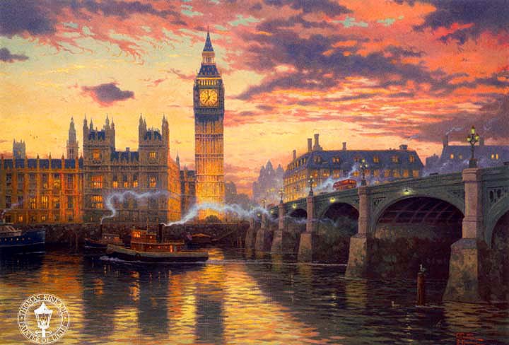
LONDRES (Canaletto, 1750)


La imagen analizada muestra una de las partes más destacables de la ciudad de Londres (Reino Unido) en el año 1750 (S. XVIII). La obra pertenece a Giovanni Antonio Canal, más conocido como Canaletto (1697- 1768). Este pintor italiano, perteneciente a la corriente veneciana del Barroco, destacó por sus pinturas en las que representaba paisajes urbanos con edificios de la ciudad. Estos edificios aparecen con una gran riqueza cromática y un dibujo minucioso con el que logra un máximo detallismo. Su estilo se caracteriza por el uso de luces y sombras junto con  composiciones teatrales. Además utiliza colores cálidos que se relacionan con la fogosidad y el apasionamiento del Barroco. La ciudad más representada en sus obras es Venecia.

En cuanto al contexto histórico de la obra, en esta época Londres posee las características propias de una ciudad georgiana (siglo XVIII), en la que habita una burguesía acomodada  y nobleza baja. Durante este periodo Londres experimentó un gran enriquecimiento comercial y  cultural. Tras la conquista de la India se desarrolla el comercio y la navegación. Por otro lado,  el compositor de la corte, Händel, escribió el Mesías. También, a finales de este siglo se publica el primer diccionario de la lengua inglesa. Finalmente, la arquitectura sufre un importante desarrollo gracias a arquitectos como John Soane o John Nash.

Respecto a la situación y emplazamiento de la ciudad, Londres está ubicada al sur de Inglaterra. Esta privilegiada situación al suroeste del país la ha beneficiado desde sus orígenes siendo la región más poblada y rica del Reino Unido. Respecto al plano urbano de Londres, conserva distinta estructuras correspondientes a las distintas fases de asentamiento. La City de Londres está situada sobre la antigua ciudad romana que contaba con una muralla. Durante la Edad Media este distrito posee una estructura irregular con los edificios apiñados sobre el plano. Esta región de Londres ha sido arrasada hasta tres veces a lo largo de la historia. En el año 1212 este distrito de Londres es arrasado por un incendio. Unos siglos más tarde esta región es  reducida a cenizas de nuevo por el famoso Gran Incendio de Londres, en el año 1666.

El arquitecto Christopher Wren fue el encargado de diseñar un nuevo plan urbanístico para la zona. De este modo, todos los edificios de La City, que eran de madera, tuvieron que ser reconstruidos incluyendo la Catedral de San Pablo de la cual se hablará a continuación. El proyecto seguía una forma ortogonal de inspiración clásica, incluyendo ejes dominantes que proporcionan dinamismo barroco. Los grandes ejes están constituidos por grandes avenidas diagonales, con el objetivo de acortar distancias y hacer destacables edificios emblemáticos como las iglesias, muchas de las cuales observamos en la imagen, grandes plazas con monumentos, palacios o museos. Este modelo urbano será imitado durante la época del Neoclasicismo en algunas ciudades nuevas de EE.UU como Nueva York o Washington.

A parte de La City, Londres está compuesto por 32 municipios (London Boroughs). Cada uno de ellos se caracteriza por ofrecer distintos servicios y actividades. Chinatown y Soho son los dos barrios más multirraciales, siendo el lugar donde se desarrolla la vida nocturna de la ciudad. En ellos encontramos desde restaurantes, bares de moda o lujosas boutiques. En el caso de Westminster y Whitehall, las actividades más comunes son de carácter turístico ya que poseen una importante carga histórica. Además, es importante citar que desde los tiempos de Eduardo el Confesor, Westminster ha sido sede del Gobierno Británico. Finalmente, destaca Covent Garden y The Strand, en los cuales encontramos famosos mercados callejeros pero también restaurantes, pubs y cafés.

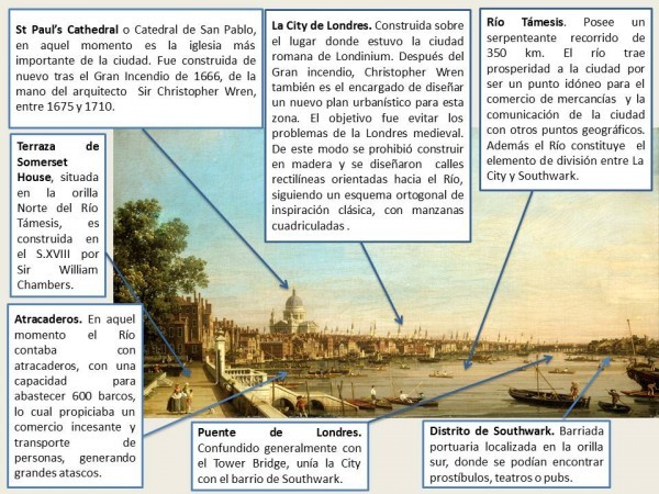
Los principales elementos urbanos observados en la imagen, son la Catedral de San Pablo, el distrito de la City de Londres, la terraza de Somerset House, el puente de Londres, los atracaderos y las barcas en el Río Támesis y la orilla sur en la que se localiza el distrito de Southwark.

La Catedral de San Pablo que retrata Canaletto es la perteneciente a la época de la reconstrucción de La City después del Gran incendio de Londres. Esta nueva catedral es construida entre 1675 y 1710 de la mano del prestigioso arquitecto Cristopher Wren. Edificada en el estilo Barroco inglés, cuenta con una gran cúpula que destaca en el horizonte de Londres desde su aparición. Además, La Somerset House, de la cual se aprecia su terraza, también pertenece a este periodo de reconstrucción. De nuevo Cristopher Wren fue el encargado de diseñar este importante edificio de Londres, que albergaba oficinas gubernamentales, sociedades científicas  y la sociedad naval. Por otro lado, los atracaderos del Río Támesis en aquella época estaban algo obsoletos, contando tan solo con 600 de ellos, se formaban grandes atascos de barcas para descargar las mercancías. En muchas ocasiones las barcas tenían que ser amarradas y con frecuencia la mercancía que contenían era robada para el contrabando. Para solventar este problema, Londres crea la primera policía fluvial que continua vigente hoy en día. En cuanto al puente de Londres, es frecuentemente confundido con el Tower Bridge. En el lugar donde se encuentra,  lleva existiendo un puente desde  la época romana. Finalmente, Southwark era una barriada portuaria situada en la orilla sur del Río Támesis. Este distrito era frecuentado por maleantes puesto que muchas actividades ilegales se desarrollaban en esta zona.

Por último se describen cuáles eran los principales aspectos sociales y culturales de la ciudad junto con las  actividades económicas desarrolladas en Londres a mediados del siglo XVIII. La llegada de la Revolución Industrial hace que muchas de las actividades desarrolladas en Londres estén directamente relacionadas con la industria. Tras la invención de la máquina de vapor en 1705 se consolidara la hegemonía naval del país. Además surge la clase media londinense. Destaca la publicación de uno de los libros más importantes en el ámbito económico, La Riqueza de las Naciones, escrito por Adam Smith, en la cual está basado el capitalismo moderno. También se comienzan a publicar las primeras novelas modernas en inglés. Sin embargo, parte de la economía de este periodo es de carácter clandestino. Existe un alto nivel de economía sumergida como consecuencia del contrabando de mercancías, pillaje y prostitución. Finalmente, es importante destacar que en este siglo se crea el Reino de Gran Bretaña, tras un acuerdo con el Reino de Gales y el Reino de Escocia, algo que convertirá a la ciudad de Londres en el punto más importante del Reino.

Mercedes Pascual de Luis
Guardar

04/15/14

LONDON (Thomas Kinkade, 2005)

SLIDE.BLOG

The painting that we are going to comment on is work of art by Thomas Kinkade, created in 2005. It illustrates a sunset in the centre of London and lets us see Big Ben Tower, Westminster Palace and the beautiful waters of Thames River. The style of the work is interesting to comment because its colour tones give feeling of tranquillity and this is the reason why I have chosen it. London is located in the south of England and is the political and economic capital of the UK. The city centre is located 60km from the mouth of the Thames, the river that runs through the city. The city is displayed after the Roman conquest. It is in the third century when Londinium becomes an important settlement. The Great Fire of London in 1666 destroyed the medieval city of London. The heart of the city is called the City of London which is the oldest part and from which developed gradually, what we now know as the great city of London.

This work of art depicts the central area of London. One can see in the background the Big Ben or The Elizabeth Tower, which was built in 1289 for the first time and was called the Clock Tower. Years later, in 1834 a fire destroyed it and they had to re-build by adding the four-faced clock and finally ended in 1859. On the right of the picture you can see Westminster Bridge. The first Westminster Bridge was a stone bridge built between 1738 and 1750. It was the second bridge that was made to cross the river, after the London Bridge and it has been very important in the South London development. In the foreground is the River Thames. It crosses London and has been the major route of communication and trade of the city. In the picture, one can also appreciate, behind Westminster Bridge, a series of buildings that belong to the 19th century. These buildings are today the centre of London, near Trafalgar Square and Piccadilly Circus, and coincide with the ancient City of Westminster. We can say that over the years London has become one of the most tourist cities. Every year many people from all over the world walk along the streets to visit the historical centre and other attractions.

Then we will discuss the urban layout and the town planning. We have to consider that town planning of the city has changed from the city origins to nowadays. London as a medieval city was very irregular and today, you can find this plan in the periphery but the centre is more regular. Maybe it is not an obvious example of orthogonal plan but Trafalgar Square and its surrounding area is very organized. From the 16th century the growth of the city has not had a regular shape.

We can talk about different sections in a city according to the Anglosaxon pattern. For example, the CBD (Central Business District) is the place where we can find de major trade of the city and the most importat buildings and skyscrapers. Another important thing about this area is its high land value that in London corresponds to Trafalgar Square and Piccadilly area. Furthermore, it can be recognized the inner city that is found around the CBD, the suburbs where most of the London population lives and, finally, the rural-urban fringe which is the farthest part from the city centre, where there are industrial areas and the land value is lower.

To conclude, we can say that today London is one of the most important cities in the world for its economic activity as well as political and commercial. It is also the largest urban area in Britain and across the European Union. London is a major human settlement since founded by the Romans, who called it Londinium. The City of London keeps its medieval measures, since the 19th century and the name ‹‹London›› refers to the whole metropolis that developed from this core. The bulk of this conurbation forms the London region and the Greater London administrative area, governed by the Mayor and the London Assembly.

María Rodríguez Cosmen

04/23/13

LONDON (19th century)

This picture portrays one of the most important places in London: Trafalgar Square. This image was made in 1890; by this time Britain had become the world´s first industrial society. Although the author of this picture is unknown, I have found it in a website about old pictures of important cities in Europe. Nowadays, this drawing is used for decorating house walls. Moreover, it is a good portray because it focuses on the historical monuments and social activities during the end of the 19th century in London.

Trafalgar Square, which was designed in 1825 and it was finished in 1845, is located in the East of the City of Westminster and bordered on all sides by other conservation areas. The City of Westminster appeared in the 11th century, when King Edward the Confessor began the construction of an Abbey at Westminster. Between the river and the Abbey he built a palace too, which is the seat of the Government. For centuries, the City of Westminster and the City of London were geographically quite distinct, until the 19th   century when it was a big urban sprawl. The present-day City of Westminster as an administrative entity with its present boundaries dates from 1965, when the City of Westminster was created from three metropolitan boroughs: St Marylebone, Paddington, and the smaller Metropolitan Borough of Westminster, which included Soho, St. James’s, The Strand, Westminster, Hyde Park… This re-structuring had the main purpose of reducing the number of local government districts in London. This borough has both shopping areas like Oxford Street and Regent Street as important cultural monuments like Piccadilly Circus, Westminster City Council and Trafalgar Square.

This image shows very important monuments of London such as the National Gallery, Nelson´s Column, St. Martin in the Fields Church and other elements located on this place. Despite London being the world´s first industrial society in 1890, there was a lot of poverty downtown whereas rich people usually lived in suburbs outside the city walls. Rich people usually went to Trafalgar Square for shopping and cultural activities so this square turned into the commercial and cultural centre of London. That is why the streets, which lead up to the square, are wide and also have a bustling activity. Moreover, one of the streets that leads up to the Square, Charing Cross, has had an important train station since 1864. As a consequence, Trafalgar square and this street had a great economic activity in 1890, because they received a great amount of tourists and people who travelled from one place to another and slept near the station. Therefore, this zone had a lot of shops, restaurants, hostels and carriages which worked like taxis too. Despite the fact that Trafalgar square is rectangular; the town planning in the surrounding area is irregular; especially this part, because it is one of the oldest areas in London, which grew around the Thames´s banks. This river and the city wall have protected London from invasions until its destruction.

The two most famous landmarks in this square are the National Gallery and Nelson´s Column. Firstly, the central part of the picture is the Nelson Column which was designed by William Railton at a cost of £47,000. Its construction finished in 1843 but the four bronze lions on the base were added in 1867 and they were designed by Sir Edwin Landseer. The column also had a symbolic importance for Adolf Hitler; that is why if Hitler’s plan to invade Britain (Operation Sea Lion) had been successful, he would have planned to move the column to Berlin. Secondly, in the background of the picture we can find The National Gallery; this is the first art museum in London and it is the fourth most visited art museum in the world. This museum keeps a big amount of European paintings from 1250 to 1900.

Besides that, in the North-East corner of Trafalgar Square we can see St. Martin in the Fields Church, which, since its first construction in the 13th century, has had a lot of changes. The church is rectangular in plan, with the five-bay nave divided from the aisles by arcades of Corinthian columns, it has a beautiful vaulted ceiling too. St. Martin in the Fields Church has a proud history of hosting some of London’s best live classical music events as well as being an Anglicanism symbol, the main religion in Britain since the 16th century. Finally, other important elements here are the fountains and the statues around the square. The two fountains, which were planned when the square was laid out in 1840, were not aesthetic. These fountains were bought by the Government of Canada; when they were replaced by others designed by Sir Edwin Lutyens. Also, the square has many statues of famous people such as Edward Jenner, who discovered “the vaccination”; the Major-General Sir Henry Havelock and George Washington.

It is curious to note that Trafalgar Square was once famous for its feral pigeons, and feeding them was a popular activity; but then authorities forbid it for sanity problems; thus today, there are few birds in Trafalgar Square. Nowadays, Trafalgar Square is used for political demonstrations, sports events and a Christmas ceremony which takes place here every year since 1947. To conclude, I wanted to highlight with this writing the importance of Trafalgar Square in the economic and social activities over the years.

Esperanza del Val Benítez
 

04/16/13

LONDON (16th Century)

This is an anonymous engraving of the city of London, located in King William Street, which represents the city in the 16th century. We can observe the old London Bridge, in which there are a large concentration of houses and shops. The image also highlights the Southwark Cathedral and many other churches. Nowadays, the old bridge has disappeared and has been replaced.

The city of London is located in the South East side of United Kingdom, seated near the river Thames. It was founded by the Romans 2000 years ago; they named it Londinium. This city with its harbor was an important population center with about 50,000 inhabitants during the Roman period. Around the city, the London wall was built. It was a defensive wall strategically placed where the river Thames is. The River Thames was the most important means of transport in the city, as a consequence of that the trade grew; allowing a further evolution and growth of population density. Due to the oceanic climate of London and the low speed of the water in the river (because it had many pillars), the river froze on several occasions, making transport and trade difficult.

The River Thames divided London into two main areas. In the North área there was Londinium where most of the churches were situated. In the South area, there was the suburb where were all the taverns, brothels and theaters. Here lived the poor people in low conditions. In the Middle Ages London had an irregular morphology. The central streets were surrounded by important buildings and some markets were installed in the back streets. The city was divided into neighborhoods which were distinguished according to the origin or the social classes. The important and wealthy people were located in the center of the city while the commoners lived in the surrounding area. In this time religion was very important, so there were many churches and cathedrals.

In London, most of the constructions were made up of wood following the Norman style. A terrible fire on September 2, 1666 destroyed the old city of London that was inside the city wall. It was a big tragedy because it knocked down many houses, churches and important buildings as the town hall. To rebuild the city, the changing needs of the population were taken into account and the new buildings were no longer made up of Wood. They were made out of brick or tile, to avoid problems such as the fire.

The economy of London was based on trade, politics, and industry. Thanks to its location next to the Thames river, trade could be developed, allowing to import and export products and goods. The industry, in particular the textile one, made the city grow and increase the number of inhabitants. Politically, it was also very important in that time. An example of it was the agreement of London (1604), signed in this city between Spain and London, which finished the Anglo-Spanish war.

In the picture we can see some important monuments such as the London Bridge. The bridge was built out of wood in the year 46. It was burned down by the King Ethelred to avoid a possible invasion of the Danes. It was rebuilt, but in 1091 it was destroyed again by a storm and in 1136 by another fire. In 1572, the bridge was rebuilt in stone and in the middle many homes, shops and a chapel were built. The current London Bridge was built between the years 1967 and 1972 and it was finally opened by Queen Elizabeth II in 1973.

Ana Isabel Carralero Marín.

04/10/13

LONDON (Stephen Wiltshire, 2008)

This work of art belongs to the collection of Stephen Wiltshire. It represents two famous landmarks, The Big Ben and The London Eye, among other monuments. This painting is from 2008, as the date is written on the picture, “23-July-2008”. The painter is a British architect who has been diagnosed with autism; his signature is at the bottom right corner. He is well known for his ability to draw landscapes from memory after having seen them just once. He founded his own permanent art gallery in London’s Royal Opera Arcade, which is full of drawings and paintings depicting detailed city environments.

This drawing portrays the city of London with a great amount of details, near the two banks of the river. The south bank was occupied by suburbs dedicated to activities pursued by the law, such as gambling, prostitution or the theater. For many centuries, there was only one bridge that crossed the river and connected both parts of the city, formed by the City and Westminster. The most important monument in the surroundings is ‘The Big Ben’, a building that was completed on the 31st May 1859 as part of Charles Barry’s design for a new palace, after the old Palace of Westminster was destroyed by a fire. Although Barry was the chief architect of the Palace, Augustus Pugin designed the Clock Tower. On the other hand, the London Eye, also known as the Millennium Wheel, was finished in 1999 and opened to the public in March, 2000. Its construction was funded by British Airways. There are also other representative monuments in London such as Westminster Abbey and the palace of Westminster. In his painting you can see the central plan of London, which is considered to be the urban core, the heart of the city.

The urban layout is orthogonal, because London was constructed around the river Thames, and it still maintains its medieval limits. The new streets were planned in a regular way, directed towards the river Thames. However, the layout of the city was still irregular, especially in some neighborhoods where the route clashed with fixing barriers. In 1666, due to the great fire that destroyed four fifths of the city, London was reconstructed taking into account urban needs, and thanks to the work of the architect Christopher Wren the city was embellished. From this year onwards, the city became the center of English social life as it contained buildings like palaces, churches, monuments, theaters, and museums. With the exception of some important monuments, the buildings were homogenized in height. The industrialization was very important, since London became the largest urban agglomeration in the world at that time, and they built new bridges, expanding the industrial peripheries.

London is one of the main business centers in the world, as well as the former capital of the British Empire, which is one of the biggest global markets, similar to other markets like in New York, Tokyo or Paris. In this city, another important activity is tourism. The industry, the financial sector and the ports sustain the daily life of London. Over the years the industrial sector has declined and tourism has increased. The most important function of Trafalgar Square is tourism, due to the presence of historical monuments such as the National Gallery and Nelson’s Column, as well as having numerous embassies nearby.

Alicia de Miguel Utrera

05/14/12

LONDRES (Stephen Wiltshire, 2009)

El centro histórico de Londres, formado por los núcleos de la City y Westminster, se sitúa en la orilla norte del rio Támesis. La orilla sur fue ocupada por arrabales dedicados a actividades perseguidas por la ley, como el juego, la prostitución o el teatro. Durante muchos siglos, sólo había un puente que cruzaba el rio y conectaba las dos partes de la ciudad. La imagen presentada aquí es un dibujo de la céntrica plaza de Trafalgar, realizado por el artista Stephen Wiltshire el 9 de mayo de 2009.

En el año 1666 Londres fue arrasada por un gran incendio, que obligó a reconstruir la mayor parte de sus calles y edificios. A raíz de esta reconstrucción la ciudad adquirió una forma ortogonal, con largas avenidas y plazas donde se situaron edificios emblemáticos como palacios, iglesias, monumentos, museos, etc. Las calles fueron orientadas de forma más o menos ordenada hacia el rio Támesis, aunque el plano general siguió siendo irregular, sobre todo en algunos barrios donde el trazado chocaba con barreras de fijación.

Con la industrialización la ciudad creció hasta convertirse en la mayor aglomeración urbana del mundo. En el aspecto urbanístico se construyeron más puentes, se crearon nuevos ensanches y periferias industriales y se hicieron reformas ornamentales en el interior de la ciudad, abriendo plazas y parques. Una consecuencia importante fue la segregación social, plasmada en la diferencia económica y arquitectónica de cada distrito (como ocurre entre el West End y el East End).

Por otra parte, los edificios fueron homogeneizados en altura, de manera que prácticamente no se diferencian entre sí, excepto en el caso de los monumentos más emblemáticos. A nivel artístico, la arquitectura de Londres no se caracteriza por ningún estilo en particular, habiendo acumulado edificios de diversos periodos. Se conservan pocas estructuras anteriores al incendio de 1666, a excepción de la Torre de Londres y algunas iglesias y restos de época medieval. Después del incendio, la ciudad se construyó siguiendo un estilo neoclásico en su mayoría, pero también ecléctico y neogótico.

Londres se divide en la City de Londres y en 32 London Boroughs (municipios londinenses). Estos municipios son la principal forma de administración local y desarrollan muchos servicios cívicos. Por ejemplo, Trafalgar Square pertenece a la City of Westminster. La ciudad en su totalidad acoge una variada serie funciones de producción industrial, comercial, política, administrativa y turística. Históricamente ha sido la capital del Imperio Británico y uno de los puertos más grandes de Europa. Además, es uno de los principales centros de negocios internacionales, y es considerado uno de los puntos neurálgicos de la economía mundial junto con Nueva York, Tokio y París. En Trafalgar Square las funciones más importantes son la turística, por la presencia de monumentos como la National Gallery o la Columna de Nelson, administrativa por la existencia de varias embajadas en sus proximidades, y de circulación de transportes entre el centro y la periferia de Londres.

Javier Mosquera Prieto


05/13/12

LONDRES (Franz Hogenberg, 1572)

 Este es un grabado de la City de Londres realizado en el año 1572 por los geógrafos Braun y Hogenberg para el libro Civitates Orbis Terrarum. Esta obra es un gran atlas que recopila más de 500 grabados y descripciones de distintas ciudades europeas, de tal forma que nos permite saber cómo era el mundo en los siglos XVI y XVII.

La City de Londres se asienta a orillas del río Támesis, en el sureste de la isla de Gran Bretaña. Fundada por los romanos como Londinium, en el año 43, siempre ha ejercido un papel dominante a nivel político. En la fecha en que fue realizado este grabado, ya era la capital de la monarquía inglesa y actualmente aquí se encuentra el corazón financiero del Reino Unido. 

La ciudad estaba delimitada por una muralla conocida como London Wall (el muro de Londres), que tenía seis puertas principales: Aldersgate, Aldgate, Bishopgate, Cripplegate, Ludgate y Newgate, las cuales daban acceso a las calles principales de la ciudad. A partir de 1761, debido a las nuevas construcciones de una ciudad emergente, muchas partes de esta murallas fueron destruidas.

Dentro de esta muralla se desarrollaba una ciudad de trazado irregular típicamente medieval, como se puede apreciar en la imagen. En ella predominaban las edificaciones religiosas como iglesias y conventos, de las que sobresalían sus torres y campanarios: la antigua Catedral de San Pablo, St Botolph´s Aldgate, St. Helen Bishopgate, St. Mary Abchurch, Temple Church etc.  En el Gran Incendio de 1666 más de 89 iglesias quedaron destruidas, al igual que cuatro quintas partes de la ciudad. Muchas de ellas fueron reconstruidas posteriormente, como la Catedral de San Pablo, que era originalmente de estilo gótico y tras su reedificación (1676-1710) se convirtió en el emblema del Barroco inglés.

Antes del famoso incendio de 1666 se computaban más de 15.000 casas de habitación dentro de las murallas. Estas casas por lo común eran de madera y por eso se consumieron rápidamente entre las llamas. Después de aquello, los nuevos planes urbanísticos tuvieron en cuenta las necesidades de la población, las viviendas comenzaron a hacerse de ladrillo y cubiertas de pizarra o teja, y los nuevos monumentos embellecieron Londres, convirtiéndola en el centro de la vida social inglesa con sus palacios, sus salones, sus teatros, sus sociedades culturales y sus museos. El crecimiento del nuevo Londres fue en gran parte impulsado con la fundación, en 1694, del Banco de Inglaterra.

Gran parte del Londres actual pertenece a las épocas georgiana y victoriana (siglos XVIII y XIX). Hasta principios del siglo XIX, la capital estaba reducida a los límites de la ciudad romana original, más Westminster y Mayfair, y estaba rodeada de campos, como se aprecia en la imagen de Hogenberg. La industrialización atrajo un creciente número de personas que llenaron estos espacios verdes. Esta rápida expansión causó graves problemas sociales y sanitarios, como la epidemia de cólera de 1932 o la «gran pestilencia» de 1858, causada por el hedor que desprendía el Támesis.

Algunas edificaciones destacadas que se distinguen en la imagen son la Torre de Londres y el Puente de Londres. La Torre de Londres fue construida en 1078 por Guillermo el Conquistador como fortaleza defensiva aunque también desarrolló otras funciones a lo largo de su historia, como palacio real, arsenal, tesorería de las joyas y ornamentos de la Corona, archivo etc. En la época del grabado de Hogenberg su función principal era la de prisión y patíbulo para la ejecución de nobles y religiosos que hubieran traicionado a la monarquía. 

Por su parte, el Puente de Londres es de origen romano y fue el primer puente que se construyó para unir la ciudad con el Southwark. En 1013 el rey Ethelred quemó el puente para evitar la entrada de las fuerzas invasoras del danés Svein Haraldsson. Después de ser reconstruido, fue nuevamente destruido por una tormenta en 1091, y otra vez en 1136 por un incendio. En 1572 el puente ya era de piedra y sostenía un buen número de viviendas, comercios e incluso una capilla, que discurrían a lo largo de el mismo. En la parte sur del puente fue tradición, desde 1305 hasta 1660, colocar las cabezas empaladas de los traidores.

Desde las invasiones escandinavas de la Edad Media, se fomentó el espíritu de empresa y el afán por el comercio. Como resultado de ello, las principales actividades de la ciudad fueron industriales y comerciales. El puerto de Londres fue uno de los enclaves más importantes para la distribución de mercancías y el comercio entre Europa y las Islas Británicas, lo que supuso un progresivo incremento de la población: 100.000 habitantes durante el reinado de Enrique VIII y 500.000 a mediados del siglo XVII. A finales del siglo XIV, no obstante, sirvió de entrada a la terrible peste bubónica. 

En el siglo XVI esta dinámica económica fue reforzada por un poderosa industria textil, a la que se añadió una progresiva centralización política y la expansión del comercio marítimo, establecida bajo el reinado de los Tudor y continuada por los Estuardo. Por esto es importante señalar en este grabado el doble papel que ejercía el río Támesis para la City de Londres: la riqueza de la producción la proporcionaba el asentamiento de la ciudad en la ribera del río, que al mismo tiempo servía de vía de transporte para la comercialización.

Fuera del emplazamiento amurallado de la City se encontraba Westminster. Mientras la zona amurallada era la zona comercial, la zona oeste era el centro administrativo donde se realizaban las funciones de poder. Westminster era usado por las dos cámaras del Parlamento y también era sede de los tribunales de Justicia. Y anteriormente el Palacio de Westminster era la residencia de los monarcas británicos, aunque a partir de 1530 la principal residencia real sería el Palacio de Whitehall.

Actualmente, Londres es una de las ciudades más importantes del mundo y forma una inmensa conurbación. La capital inglesa sigue creciendo, lo que la convierte en una de las áreas metropolitanas más grandes de Europa. A este crecimiento ha ayudado el constante desarrollo de las industrias y las nuevas tecnologías, así como el avance de los medios de transporte. En cuanto a sus funciones, sigue siendo una ciudad comercial y de finanzas, a la que se le añade el factor del turismo como fuente de ingresos.

Gloria Madrigal Aparicio y Marta Serrano Jiménez