
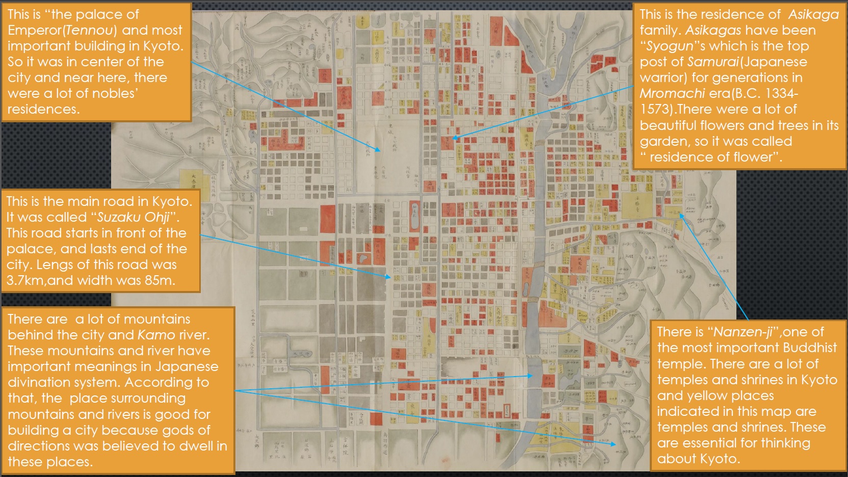
The title of this picture is 応仁 以前 京都 図 (Ounin izen Kyoto zu), and it means «The map of Kyoto before Ounim». Ounim is the name of a Japanese era corresponding to the reign of one dinasty of emperors between 1334 and 1573, although it is more commonly known as Muromachi era. We do not know the author of this map because the status of a painter was not considered important in those times. It was made around 1467-1468 and now is collected in Tokyo National Museum. This type of painting focus its attention on understanding and recording the entirety of the city.
The map shows the location of every building in Kyoto in addition to mountains, lakes, rivers and other landscape features. Also, there is a big river in the East part which is called Kamo river. It is easily appreciated how the streets follow a very orthogonal plan with the emperor’s palace in the city center. The main road start from that central point and is named Suzaku-Ohji. Suzaku is the name of one god and Ohji means «big road». This type of urban layout comes from China because it is based on the Confucianism theories. The model for Kyoto was the city of Xi’an, that was the capital of China and one of the most modern settlements in Asia in that time.
There is another explanation for this regularity. According to Japanese divination, four gods live each in four directions (North, West, East, South), dwelling the big mountains, the rivers, the lakes and so on. This is why the symbolic connection between the natural landscape and the urban space is so important. As we can see, there are mountains in the North and West of Kyoto, and the Kamo river flows by the East; there is also a huge lake in the South although it is not possible to distinguish it in the picture. All this turns Kyoto into a very special place to host the capital of the Japanese empire.
A lot of buildings are geometrically represented along the streets; the ones coloured in red are large noble residences (many of them belonging to samurais) while the yellow places indicate Buddhist temples and Japanese shrines. The most significant one, and one of the oldest, was the Nanzen·ji temple, that was built in 1291 and was given special treatment by the Syogun (the top post of samurais). We cannot see in the image but in the Northeast there is is a great Buddhist temple called Hieizan Enryaku·ji that was believed to be the «Gate of the Devils» and needed to defend the city against the evil forces.
Kyoto was the capital of Japan for a long time, from 794 to 1867. It was built up by Emperor Kanmu and reached its top in 1334 when the powerful Syogun Asikaga Takauji established a military centralized government here. During that time, the city increased its population and prospered economically but in 1467 a very big war happened (the Ounim War) and Kyoto was severely destroyed. The map represents the city before that war.
Yoshiaki Okada