
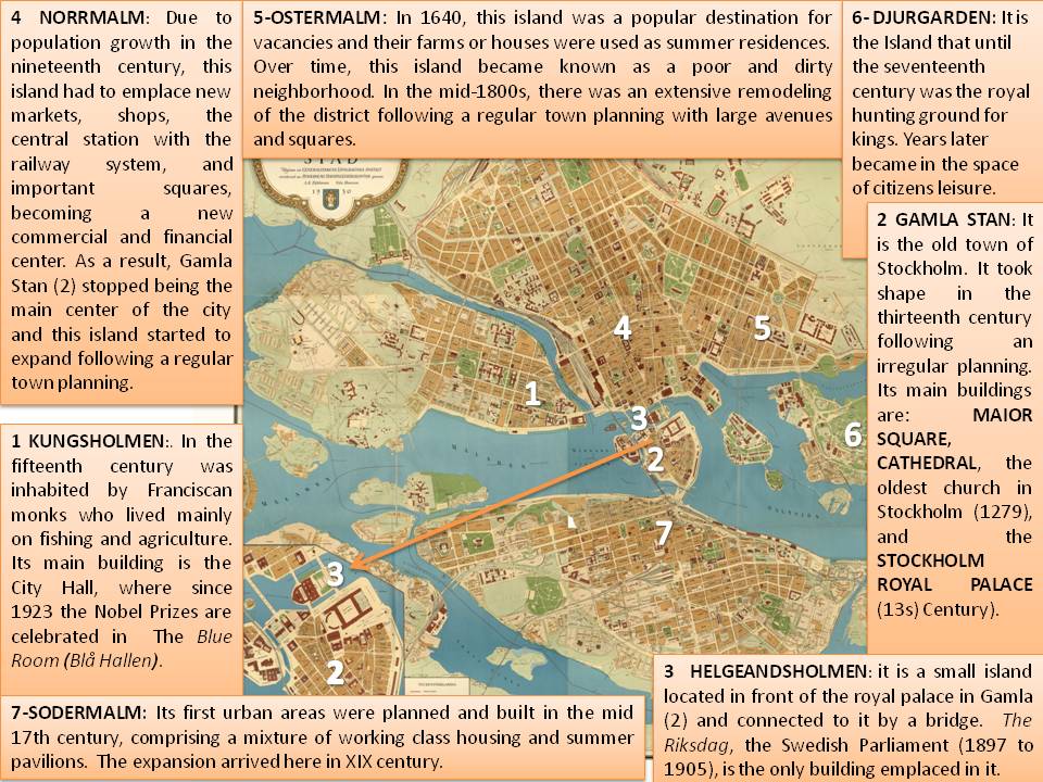
This map represents the shape of Stockholm city, in Sweden, during the XX century (1930). It has been found in a government website where a lot of old maps are displayed. The only information related to the publishers is that the image was emitted by the Mayor State Pahlman and Hanzon (Generalstaben genom Påhlman och Hanzon). The importance of the map is that it shows the distribution of the city in several islands and its expansion and evolution due to the population growth in nineteenth century. Since its origins in the thirteenth century to defend the Malar Lake area and promote the sea trade, Stockholm became one of the main cities in Sweden due to its strategic geographical position. However it did not grow much until the mid-nineteenth century with the Industrial Revolution, when many industries were located in the capital, causing high immigration from the field and creating the urban structure showed by this map.
According to the layout and the social and economic issues, it is clear that this city is composed by several islands over the Malaren Lake connected by bridges. Interestingly, we can point out two different shapes of urban spaces attending to the age of the islands: the center of the map (Gamla Stand and Kungsholmen islands), which follows and irregular town planning, and the north and south of the map (Normalm, Ostermalm and Sodermalm), where the expansion of the new city was emplaced following a regular urban structure. Gamla Stand is the old town of Stockholm and it has an irregular layout with narrow cobbled streets and medieval german style buildings. Due to population growth in the nineteenth century, as the picture shows, the expansion area (Normalm and Ostermal) started to emplace new markets, shops, the central station with the railway system, and important squares, becoming a new commercial and financial center. As a result, Gamla Stan stopped being the main center of the city, and Normalm and Ostermal started to expand following a regular town planning based on a reticular expansion with rectangular blocks and open squares. These expansion areas were connected to Djugarden district by a bridge in order to keep in contact to the leisure island in Stockholm. Innovations in transportation can also be seen in the map in the railway line, built in 1860. The railway follows the river in the north to promote the commercial trade, goes over the water through the central island, Helgeandsholmen, where the administrative center is located (Swedish parliament), and continues on the south where it is divided on the east along the coast (Sodermalm) and on the west through the city. This railway settlement emphasizes the foundational idea of Stockholm as a port city.
Regarding to the monuments displayed in the map, there are a lot of outstanding buildings that determined the layout of the city and the uses of each island. For example, the little island located in the center of the picture contains only one building, The Swedish Parliament. In addition, there is an island dedicated to citizen´s leisure where there are important elements, such as the first open air museum and amusement park in the world. Lastly, is needed to highlight that the most remarkable building in the map is the Royal Palace, located the old town (Gamla Stand). The first building emplaced in this place was a fortress with a central tower built created in the thirteenth century by Birger Jarl in order to defend Lake Mälaren. The fortress grew into a palace, called Tre Kronor («Three Crowns»). In the late sixteenth century many works were made to transform the old fortress into a Renaissance palace under the reign of King John III. At the time of this map, 1930, the royal family still had residence in this palace. From 1981, they set the Drottningholm Palace as a real residential in the outskirts of the city.
To sum up, according to the social activities, in the thirteen century, the main activity in Stockholm was the sea trade because of its location in Malaren Lake. After industrial revolution in XIX, this city became in an economical area based on industry (exportations of wood and other raw materials), and services such as tourism, finances or new technologies.
Ana Orche de Tomás
This is a great job! It is amazing how cities have changed by the ages.