04/26/14

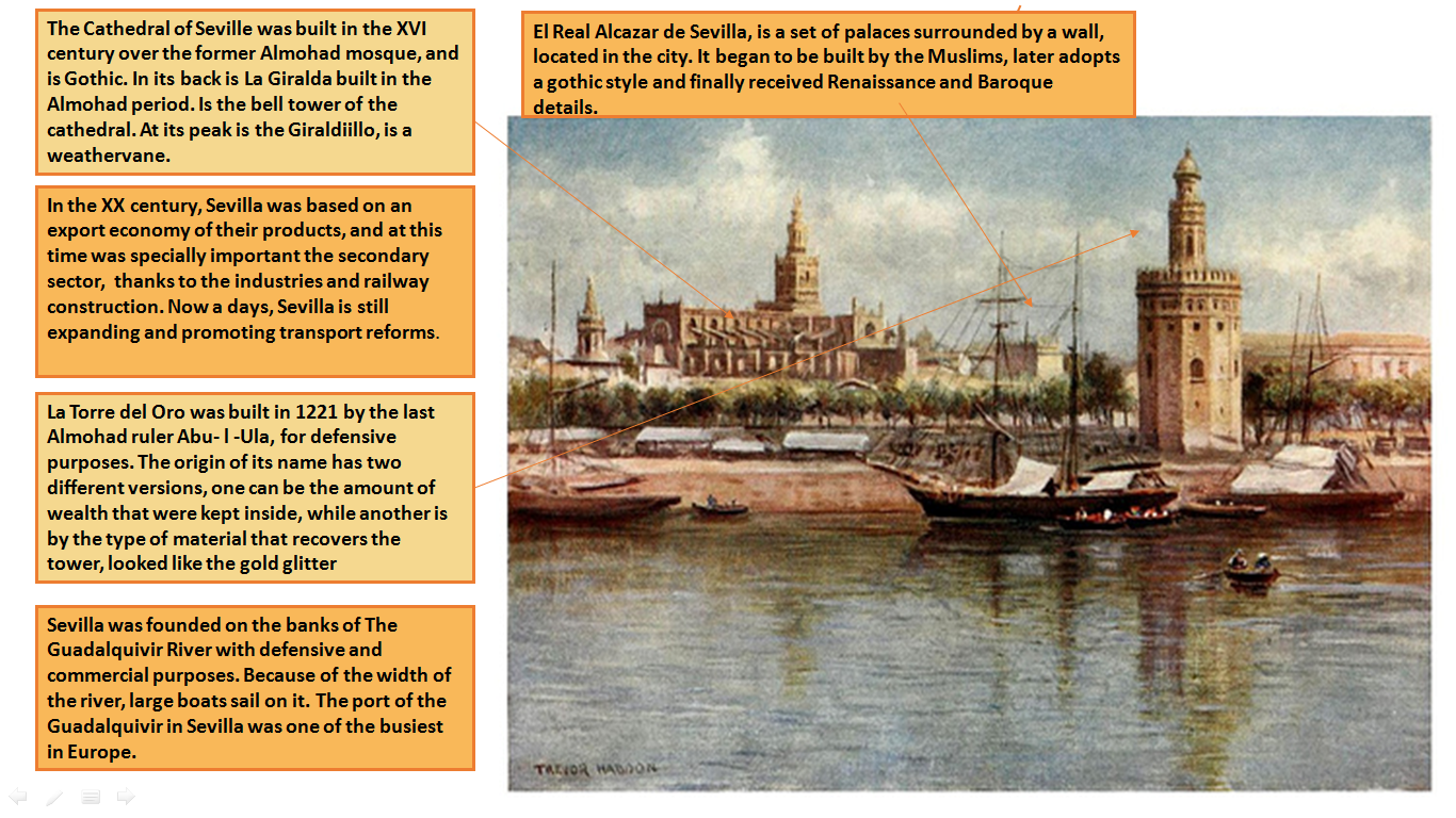
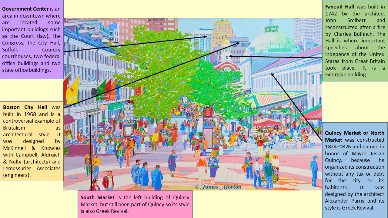
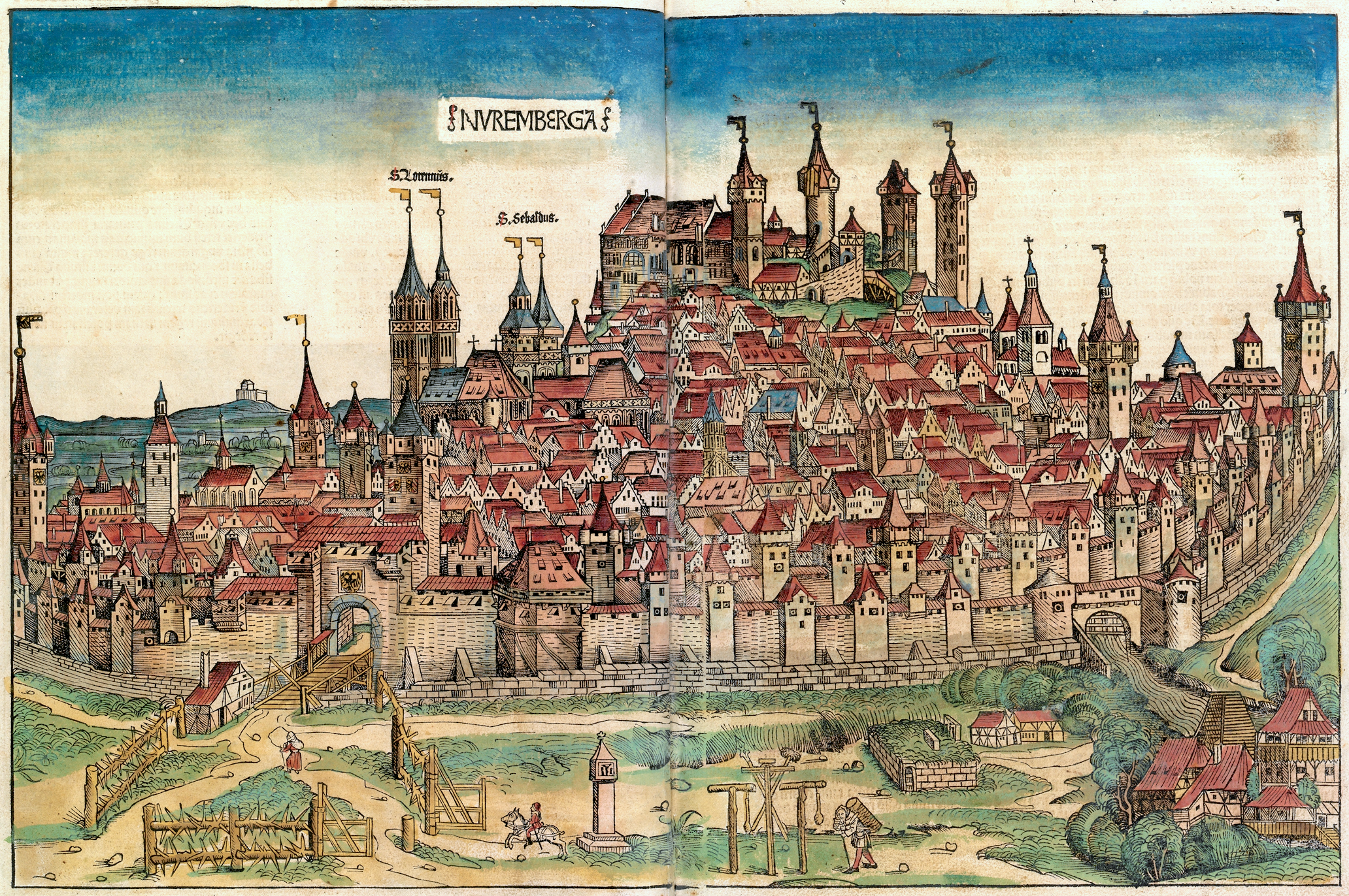
UDINE (Joseph Heintz, 1650)

Udine (Joseph Heintz, 1650)

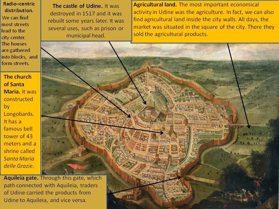
This beautiful painting is located in the Civici Musei di Udine, in the Galleria d´Arte Antica, in Udine, Italy. It depicts a general view of the city of Udine in the 1650´s. The painter is Joseph Heintz The Young, who was born in Ausburgo as a son of the artist Joseph Heintz The Elder. When his father died, he moved to Venice and there we can find many of his paintings such as The miracle of the mule or the final trial, among others.

Udine is a boundary city that shares a northern border with Austria, an eastern border with Slovenia, and a southern border with the Adriatic Sea. Due to this strategic position it was a very important piece of the European political map. Its primitive settlement is supposed to be Celtic and later Roman. In the image we can see the aspect that Udine had in the end of the Middle Ages and the beginning of Modern Times surrounded by impressive city walls. When Udine came into the Venice´s republic (around the year 1420) the original Roman city walls were demolished and the city was extended to the periphery, creating the new walls that can be appreacited in the picture.

In relation to the town planning, it is radio-centric. Besides, we can observe that houses are gathered around blocks, most of which form small streets that lead to the city center. The houses are regularly grouped in squared blocks. This is because the city in the image conserves its Roman orthogonal town planning. It is important to highlight the channeling of the river, which is conserved in the city plan in order to make trade and communication easier. In the centre it is located the church of Santa Maria which is the oldest one in the city. It was built by the Longobardos and it was constructed with a bell tower 43 meters tall.

We have to mention that the most important economic activity in this period in Udine was agriculture. As a point, we can find inside the city walls some farming plots, so most of the population worked as farmers. Therefore, the market was located in the main square of the city, and there, traders sold their products to the rest of the population. In fact, most streets had the name of the profession that took place in this street. Although the most important job at this time was the agriculture, there were other important jobs, such as the craftsman, the blacksmith, the cattle rancher, etc.

Sergio Morales Rodero
 

04/22/14

CIUDAD RODRIGO (1812)

Alba Bolívar González. CIUDAD RODRIGO

This picture represents the Siege of Ciudad Rodrigo according to a map preserved in the Servicio Histórico Militar of the Spanish Ministry of Defense. This historical event began on the night of 8 January 1812, when 450 men from the Light Division seized the French redoubt on the place of Grand Teson. Many wars destroyed the city, such as the Portugal Secession in the 17th century, the War of the Spanish Succession in the beginning of the 18th century, and the War of Independence against Napoleon, in the beginning of the 19th century. The last one provides the historical event referred to this image. In June, 1810, Napoleon wanted to conquer Ciudad Rodrigo which suffered a hard siege by the French army for several months but the city was finally released by the Duke of Wellington.

Ciudad Rodrigo is located in the southwest of the province of Salamanca. It is just a few kilometers from the Portuguese border by the west and also a few miles by the south of Caceres.  The city is located on the banks of the Agueda River, a tributary of the Duero that can be seen in the image. The urban setting of Ciudad Rodrigo is due to its strategic position in a border area and therefore is a warfare zone. Agenda River is born in the Gata mountain range and is on the border with Portugal and Caceres.

The city was surrounded with a great wall since the Middle Ages and this influenced in the urban layout. The morphology was determined by the defensive needs of that time as we can appreciate in the picture. In addition, the streets are narrow and irregular, and the city center is dominated by the cathedral and the market square that hosted the social activities. The neighbourhoods were divided according the guilds, ethnics or even religious beliefs. In the late 15th century a second city wall was built with large circular towers to house the old enclosure. Outside the wall we can see that there are some suburban areas that have been built up to the present.

The 14th and 16th centuries were the most brilliant period in the history of Ciudad rodrigo because many religious monuments and buildings were built. Among the religious monuments, it should be noted the Cathedral and the Cerralbo Chapel, built by Cardinal Pacheco, in addition to the church of the Venerable Third Order or the church of San Pedro-San Isidoro, with a mixture of diverse styles such as Romanesque, Moorish, Gothic, Renaissance and Neoclassical. The Franciscan convent was constructed in the 20th century outside of the Citadel because it turned out to be much damaged during the War of the Independence. Among the civil buildings we can include several palaces such as the Eagle House, the palace of the Marquis of Cerralbo and the House of Castro. Also interesting are the City Hall and the Hospital of the Passion, one of the oldest hospitals in the world that continues serving; this hospital has its origins in the 16th century when was built over the Jewish quarter. Finally, among the military buildings we can include the castle, built by King Henry II, and the moat and wall that are perhaps the most important monuments and were commenced in the twelfth century.

Another monument that we can see on the map is the Castle. The name of who had it made is unknown, but the castle was rebuilt by Fernando II. It was attacked on several occasions during the fighting that devastated Castilla y León throughout the Middle Ages. It was rebuilt by Henry II Trastámara, in 1372) During the War of the Spanish Succession and the War of Independence it was again the scene of struggles, up to be completely dismantled. Finally, when this was again restored, it was converted into a fantastic Parador hotel.

Alba Bolívar
 

04/21/14

ZURICH (Braun & Hogenberg, 1581)

Slide1

This is a picture created by Georg Braun and Franz Hogenberg in 1581 representing the old city of Zürich. It is found in the book «Civitates Orbis Terrarum» which traslation into English is «World Cities». In the past Zurich was called Taricum. From the 16th century a lot of religious controversies took place and in 1523 and Zurich was separated from Catholicism. It was the first city that adopted the Protestant Reformation in 1519. Right now Zürich is the biggest city of Switzerland with a population estimated at 390,000 inhabitants. But in the era of this picture the population felt down because of the witch hunt.

Zurich is located at the two sides of the Limmat River. The Alps are situated at 30 km of the city. Zurich is sourrounded by two leafy hills. In the picture we can find two types of morphology. On the left side of the picture the town layout is irregular, whereas on the right side the town planning is more regular. A fortified city wall surrounds the whole city. Concerning urban structure the old quarter of the city is placed in the Kreise district that is ordered in the direction of clockwise. The most important districts are the number 1, also known as Altstadt, which is situated next to the Zurich Lake. It is part of the old-quarter. Another important district is the number 4, where nowadays is situated the rail station.

In the old-quarter we can find the most specific buildings of the city such as churches, public buildings and bourgeois houses. The biggest church is the chatedral Groosmüster, built in Romanesque style. It is located on the right side of the river. It was founded by Charlemagne, dates between the 9th and 13th centuries. The church of Fraumünster, also built in Romanesque style, was founded by the grandson of Charlemagne. San Peter’s of Zurich is oldest church of the city, we can find it at the bottom of the picture. On their bell tower is found the biggest clock of Europe. Other important tourist attractions are the City Hall of Zurich, built in Baroque style, and the square and the avenue of Paraplatz, located at the bottom of the image; that is fixed to the old Wall. On the left of the picture we can see the current National Museum, which looks like a castle. Inside it is founded the greatest historical and cultural collection of the region. Culturally, Zürich is a city that have a lot of museums, galleries, theatres, also a symphonic orchestra and numerous festivals.

If we focus on the outskirts of the picture we can see that in this area one of the most important economic activity in those days was agriculture. But also if we observe the river the picture shows that there are a lot of movement. What we can deduce that another important activity was the carriaged of hoods. In relation of this topic we can say that during the Roman times the city was an important commercial port. Looking at the picture in detail we can appreciate that in the wall surrounding the city there is a lot of towers. In some of that towers we can distinguish a gate. The most important gates are situated in the background, in the foreground and on the right hand side of the picture. Also we can appreciate that the street that beging on the gate located at the right is the main street of the city. That road crosses all the quarter of the city located at the right side of the river.

An interesting historical fact is that Napoleon entered without opposition into Switzerland in 1798 and created a new Constitution for the Swiss Republic. But the Austrian Army under the authority of the archduke Charles, defeated the Napoleonic forces in the Zurich battle. In 1811 the historic walls fell down and in 1815 it was declared a neutral city. Since the end of the 20th century, Zurich has been the financial centre and motor of Switzerland. In addition there are the headquarters of a lot of Banks and insurance companies. Moreover Zurich is a city that have a lot of museums, galleries, theatres, also a symphonic orchestra and numerous festivals.

Claudia Navarrete Adán
 

04/16/14

SEVILLA (Trevor Haddon, 1904)

2014-04-16_19h33_16

This image is a watercolor by Trevor Haddon, painted in 1904. Trevor Haddon was an English watercolorist who performed most of his work traveling around Spain, especially in Andalucía. In the picture we can appreciate the city of Sevilla with its Cathedral, Giralda, Torre del Oro, Real Alcázar and the Guadalquivir River.

Sevilla is located in the south of Spain, Andalucía, within a large alluvial plain of the lower course of the Guadalquivir River. This city holds a lot of history and has different versions of its origins. The most accurate of all tells that the Romans entered during the Second Punic War at what the natives called Ispal. Julius Caesar romanized the name and step to be Hispalis. In the middle Ages, after numerous wars, the territory turned to be Visigoth and Christian. Later became a Muslim territory called Isibilia, a head of Cora, and over the years became an independent territory with the name Ishbiliya. It was in this period when Sevilla began to grow culturally. Thus, most of Seville heritage is influenced by Muslim characteristics. The city was surrendered to the Christians in 1248, and most of the Muslim buildings were rebuilt by Christians with completely different characteristics. In Modern Times, Sevilla became one of the busiest commercial ports in Europe and it experienced a huge economic boom that was reflected in its Baroque architecture and town planning. From the XIX century on, Sevilla has updated both its industrial activity and its infrastructures, and it began to expand as a significant metropolitan area.

This city has a defensive origin so it was a walled city. The center of Sevilla is the old quarter, El Barrio de Santa Cruz. It has an irregular plan with narrow streets, it belongs to the type of Muslim towns. Although, in some parts becomes radio centric, as we approach to the outskirts, the plane is orthogonal. In the river port there is a modern part that does not belong to Muslim characteristics, it is just a renewal. The Guadalquivir River divides Seville into two parts, leaving aside the district of Triana. It was from the Guadalquivir River where Columbus boats departed to America in 1492, because this river is wide enough for large size boats to navigate. Due to the same reason Sevilla has always been a city for maritime trade.

The city has a rich heritage, and most of it is located in the center. In the background we can appreciate the Cathedral de Santa María de la Sede; it is Gothic and was completed in 1507 by Ysambret and Carlin, and built over the old Almohad mosque. Behind the cathedral we can see the Giralda; it was the minaret of the old mosque and was built during the Almohad period, between 1184 and 1198, by the architects Ahmed Ibn Baso and Alí de Gomara ended. Now the Giralda is the bell tower of the cathedral and its peak is the Giraldillo, which is a weathervane. We can also observe the Real Alcazar de Sevilla, that is a set of palaces surrounded by a wall; it began to be built by the Muslims, later adopts a Gothic style and finally received Renaissance and Baroque details. In the foreground, on the banks of the Guadalquivir River, it is possible to appreciate the Torre del Oro, built in 1221 by the last Almohad ruler Abu- l -Ula, for defensive purposes.

In the first half of the XX century, the time of this painting, Sevilla was one of the most populated cities of Spain. It was based on trade economy and had a lot of weight the secondary sector thanks to the industries and railway construction. Nowadays, Sevilla is still expanding and promoting transport reforms.

Ana Romero Vergara
 

04/16/14

FRANKFURT, (Braun and Hogenberg, 1605)

Power Point Frankfurt

To begin this work, I will mention that this image is based on a view from the southwest of Frankfurt in the 17th century. It is located in front of a navigable river called Main (Meno), which gives this place the name of “Frankfurt am Main” and allows to differentiate this city from the other “Frankfurt an der Oder”. Its port is facing the river and is an important point for communications. This place was already inhabited about year 3000 BC and has been confirmed by the archaeologists as a significant economic and trade centre.

There is a neighbour town called Sachsenhausen, which is situated on the other side of the river and characterizes the city structure. In the picture, this is connected to the old centre of Frankfurt by a medium bridge called Alte Brücke. As we can observe, the shape of Frankfurt is predominantly linear in both sides of the river. In the same way, the image shows a nucleated pattern, in which houses are clustered around the main features of the city. The surroundings of our mentioned city are composed by high fortress for the protection of the population, which in that time were about 20,000 people.

The painting displays, as it was mentioned before, a bird’s-eye view of Frankfurt centuries ago. But it also shows the innumerable historical buildings and places that this city had. Some of the several ancient constructions and places are: Römerberg Square, Frankfurt Cathedral, Carmelite Monastery, Der Römer and the Church of the Three Kings. Thereby, in the first place we recognise the Römerberg Square situated at the center of the picture. Nowadays is one of the most visited places in Frankfurt, inasmuch as we find it in the old town of the city, at the right bank of the river. Its main characteristic is the presence of the Der Römer and the fountain of justice. Secondly, it’s easy to identify the 95 metres tower of the singular Frankfurt Cathedral. This enormous structure was built in the 15th and is located further right from Römerber square, specifically in Domplatz. It is interesting to notice that the coronation of the Emperor (from 1562 to 1792) took place in this marvelous cathedral. The next place to mention is the Church of the Three Kings, known as the Church of Magi. This wonderful place is located in the left bank of the river, crossing the bridge. This architecture was built as a Gothic Chapel in 1340 AD, and almost two centuries later was the first congregation in the city to reach the Reformation. Later, in 1690, the old Gothic structure was modified into a Baroque one. The next text square refers to the other important and most photographed building in Frankfurt, Der Römer.

Located in the aforementioned Römerberg Square,consists in a Gothic complex formed by three separated houses built in the 15th century. It suffered severe damages during the Second World War, but it was rebuilt after that. This stunning building witnessed the fortress built by Emperor Charles Magne to protect the city. To finish with this explanation about some important places in this city, I will talk about the Carmelite Monastery. This building is a Gothic monastery that can be shown on the left hand side of the image. What differentiates it from others, are the wall paintings made inside by Jerg Ratgeb from 1514 to 1517. These wall paintings are the largest known to the north of the Alps from that age.

The picture we have got here displays a Middle Ages city that increased its economy because of the fairs and commercial activities that had been taken place since 12th century. The main fair activities were: the autumn fair (since the 12th century), the spring fair (since 1330) and the book fair. This last one reached international proportions by around 1600. Nowadays, it is said this ancient city is consider to be an important shopping centre, with a famous street full of shops called Zeil. Since this image was painted, Frankfurt has developed from a successful way, increasing its population until 680,000 people.

Jimena Iruela Rivera

04/16/14

PRAGUE (Braun & Hogenberg, 1573-1578)

PresentacionPraga

In the picture, a copper engraving and later handcolored made by Georg Braun and Franz Hogenberg between 1572 and 1578, we could see the city of Prague in the late XVI century. Prague is the capital of Czech Republic and also of Bohemia, and it is situated in central Europe. The city is located in a meander of the Moldava River near the point it reaches the Elba River. In the right bottom part of the image is observable the transporting of logs by water. As the Moldava River is navigable, it was an important trade spot between the Slavic world and Western Europe, and served as a crossroad for several trade routes.

Concerning its urban structure, the engraving shows three main areas. On the top of the hill is situated the Prague Castle and the cathedral. This positioning is reminiscent of ancient Greek cities, in which you could observe the separation between the areas of worship and the ones where the inhabitants live. Under the castle, the others two areas have an irregular layout from the Middle Ages. The one on the left is the old quarter, also called Malá Strana. One can appreciate easily the clustered distribution of the houses surrounding a big square. The part on the right is called Old City or Stare Mesto. We could also see the city walls around. Related to the style of buildings, the majority of them are Gothic.

Connecting the two parts of the city we can observe Charles Bridge, made of big stones and built between the XIV and XV centuries. The measures are a bit more than 500 meters length and 10 width. It is named after his creator, Emperor Charles IV, who put the first stone in 1357 to replace Judith Bridge, another one destroyed by floods.

Inside Malá Strana we could appreciate some architectural ensembles. The biggest and most important one is the Prague Castle, which stand out in the background of the picture, in a strategic position from which you can see the whole city. Inside the castle is located Saint Vito’s Cathedral, a Gothic temple that started being built in the XIV century. It is obvious that the religion and the real family were very important in that period of time because of the location of those buildings. Another beautiful site is Saint Nicholas Church, a Baroque construction well known as a consequence of its very big dome easily observable from the top of the city.

On the right side of the river, the Old City, is located the main square of Prague called Old City Square. This area is the focal point of Prague nowadays. In that place one can notice the marvelous Astronomical Clock, a part of the city hall. It was made in XV century. In that square is situated another important Gothic building, Tyn Church. Another remarkable place to take into account is the Powder Tower, built in 1475. It is a blackened tower that was one of the old entrances to the city. It is important to mention that at the top part of that area is located the Jewish Quarter, where there are six synagogues distributed over that district.

We should mention that the biggest expansion of the city took place between XII and XIII centuries because of the political and economic prosperity, so that is the reason why most of the monuments and buildings are Gothic. Then, during the XIV century under Charles IV, Prague enjoyed its heyday. The king erected the Bishop’s Palace in 1344 and constructed the university four years later. It was one of the most important cities in Europe, and a consequence of it was that the great European artists moved there, especially Italians. The decline of the city started with the Counter Reformation and with the Thirty Years War (1618-1648). However, it recovered a little in the XVII century, when the Baroque style flourished.

To conclude, we want to highlight that instead of the World War 2 or the URSS’s debris, nowadays Prague is one of the most visited cities all over the world because of his importance both historically and artistically. We are sure it will continue because the only way to realize the beauty and the magnificence of that place is seeing it in person.

Álvaro Rodríguez López

04/16/14

MECCA (Muhammad ‘Abdullah, 1845)

Diapositiva1

This untitled work of art belongs to the Islamic Art collection of Nasser D. Khali and was part of the exhibition “Hajj: journey to the heart of Islam” which was on view at the British Museum two years ago. It is executed in ink and watercolor, dates about 1845 and represents the earliest known accurate panoramic view of Mecca that combines a plan of the city with a bird’s eye view. The author is Muhammad ‘Abdullah, who was a Delhi cartographer commissioned by the Sharif of Mecca to depict monuments of his kingdom.

The sacred city of Mecca is the capital of Makkah Province in Saudi Arabia (Western Asia), and is located in a valley. The city follows the windings of the valley that has an irregular shape, which also contributes to the irregularity of the houses situated in the decline of the mountain side. It is 80 km from the Red Sea. Although the planning town is irregular it should be noted that a large number of buildings are clustered and distributed around a central point, which is the Grand Mosque. As we can see, the majority houses are made of stone with flat roofs. Nowadays, the distribution is different due to the current expansion works of the Mosque and buildings are higher and constructed with more resistant materials in the inner zone. In addition, the territory has expanded and we can find some suburban areas around the city.

In the past and due to the lack of space, the markets were located along the main streets. At the present time, we can find large shopping centers in the downtown and major complex owned by the government: such as Abraj Al-Bait Towers which is the fourth highest structure in the world. Mecca currently has two million inhabitants, while in the 19th century, time the picture belongs, the number did not exceed one hundred thousand.

The most remarkable fact about this city is religion. Mecca is the birthplace of the Islamic religion and where its prophet Muhammad was born. All the places mentioned in the image are closely related to religion and Muslim beliefs. First of all, in the center of the city, we can see Masjid al- Haram, which is the world’s largest mosque and surrounds one of the most sacred monuments of Islam, the Kaaba. According to the Quran the Kaaba was built by the prophet Abraham and his son Ishmael and, during daily prayers, Muslims, from wherever they are, must pray toward the Kaaba. During the Hajj, the annual and compulsory pilgrimage that Muslims have to do at least once in life if they have enough resources, Muslims have to walk seven times around the Kaaba in a counter clockwise direction (tawaf ritual). Also, next to this monument is placed the holy well of Zamzam. A few hundred meters west of the Grand Mosque, the house where the Prophet Muhammad was born can be seen. At both sides of the image there are placed the two major mountains: Jab al- Nour and the Hira cave on the left, and Mount Arafat on the right. The first one is where the Prophet received his first divine revelation from Allah, and the other, is where Muhammad gave his last sermon to the Muslims who accompanied him in the Hajj. It is a mandatory stop for all pilgrims and here they have to pray for mercy for an afternoon, at least.

Finally, is an outstanding aspect that about fifteen million people (tourists and pilgrims) visit Mecca every year.

Lourdes Méndez Sánchez

04/16/14

PENÍSCOLA (Ernest Descals, 2008 )

Peñíscola PPT

This work of art was painted by the artist Ernest Descals, whose signature is placed in the bottom right hand corner. It is an oil on canvas painted in 2008 of Peñíscola (Castellón, Community of Valencia, Spain). At the beginning, Peñíscola was named by the Greeks in the 4th century AD as a translation of the word “península”. Later, the Latin speakers named it “pene+iscola” which translates approximately as “almost island”. Finally, we have Peñíscola in Castilian.

Peñíscola was named a city by King Felipe V in 1709, with this words “Muy Noble, Leal y Fidelísima Ciudad”, thanks to the support given to him in the War of Spanish Succession. The town was declared an historical and cultural site in 1972. It is a place with more than 2,500 years of history. Here, Iberians, Phoenicians, Greeks, Romans, Carthaginians, Arabians and Christians have settled because of its great location in the map of Spain.

Among the urban features, the Templar castle was declared an historical and artistic national monument in 1931. The style of art is situated between roman and gothic. Moreover, the fortress takes up the most elevated zone of the city with an average height of 20 metres, 64 metres above the sea level and 230 metres perimeter. But nowadays only three or fourth parts exist because in the War of Independence, in 1814, General Elio tried to recover the city which had been previously conquered by the French. Therefore, we can observe that its best characteristic is its strongly fortified defenses. A remarkable fact was the stay of Pope Benedict XIII, Pope Luna or Pedro Martínez de Luna, who made it a Pope castle in 1415-1423. The castle has always been occupied by noblemen. Interestingly, this castle is the second most visited monument in Spain, after the Alhambra of Granada.  Inside, we can find a church, a library, the stables, pontificate rooms, the meeting room of the conclave, the gothic meeting room of the commander, the dungeons… As a consequence of the Pope castle and the two churches mentioned in the image, that we find in the reduced space of the old quarter, we can deduce that the religion, at least in the past, had a great importance.

In the image we can appreciate the North beach of the city and the housing surrounded by city walls with the old medieval quarter. The Templar castle is at the top with an irregular planning town. It is so important because it is the origin of the city. Then, we find a group of white houses. They are very narrow, tall and surround the castle, forming the “village”. This is where general population and the bourgeoisie lived. The long, narrow, parallel and perpendicular, sloping streets provided defence in case of enemy attacks. Moreover, this houses served as a supplement and support for the castle because there form the modern city expansion, with regular houses resulting in a grid system. All of it is protected by the city walls, the boundary. Later, in 1960, with tourism the city continued to develop and houses outside the walls began to appear. They were near to the beach with a long boardwalk and some hotels, forming the residential periphery. Then, in the outskirts there are some industries, houses, urbanizations and a lot of land without houses because there is a lot of protected space and likewise due to the agrarian activity.

Peñíscola is in a very good location due to the proximity to the sea. The old quarter is nearly completely surrounded by water, from where the population could escape easily, while having a fishing and sea trade. Also the whole city is surrounded by cliffs (a great characteristic of its defence), beaches, fountainheads and rivers (one of which is an underground river). Furthermore, here we find the Natural Park of the Irta Mountains with a height of 573 metres and a longitude of 15 kilometres and the Marjal, both of which are very significant.

In addition, Peñíscola´s port has always been an important infraestructure for trade. Therefore, there is a Sea museum where we can learn about the history, fauna and fishing. It was the exchanging point of Peñíscola´s wine and olive oil for manufactured products such as factory and arms that arrived at the port. Apart from the sea trade, agriculture has always been an important factor for economic development and business. Wine, Carob, Olive tree and Almond tree were and still are the most cultivated plants.

To conclude, we should mention that in 1890 Peñíscola lost its military relevance due to the arsenal being moved to Cartagena. That led to the beginning of tourism and a significant economic activity. At final, emphasize with the most important function of Peñíscola, which served for controlling the sea and it had and has an important port for Spain.

Olga B. Celda Alonso
 

04/15/14

PALERMO (Braun & Hogenberg, 1572)

AnaOrtizDeZárateRuiz. La ciudad en el arte

This work of art belongs to an atlas made by Georg Braun and Hogenberg that is one of the most impressive collections of Renaissance cartography. It represents the city of Palermo and it surroundings in 1572. Georg Braun was a renowned geographer and is the author of over 500 maps and plans. Franz Hogenberg worked with him and made some designs as well. The picture is an engraving that centres its attention on urban life and commercial activities during XVI century. It portrays also some of the main elements of the city, such as the Port of La Cala or the Cathedral.

The city of Palermo is the capital and the most populated city of Sicily. It is located in the north of the island and has a very rich heritage related to its long history and its geographical position in the Mediterranean Sea. The urban planning of the city is a mixture between irregular and orthogonal, as a consequence of the unthinking growth and its spreading like a fan into a bay. In the picture, the city is crowned by Mount Pellegrino. The mountains slope down towards a green plain called Conca d’Oro which was depicted by the painter in a very attractive way. Palermo had a limited growth due to being limited by the topography and the sea. It offers spectacular panoramic views and a great variety of landscapes, for example rocky and rough mountains.

In addition, the whole city is surrounded by medieval city walls which main functions were to give protection to the city. In Modern Times  the population settled in the outskirts, around the city walls. Nowadays Palermo has grown very much and it is divided in eight neighborhoods.

At the bottom we can see the port of La Cala. Due to the fact that Palermo is located by the Tirreno Sea, it has a wide range of communication possibilities and its geographical position makes it ideal for trading. Furthermore, the engraving tries to represent the maritime activity of the city with the different boats in the water. On the other hand, nowadays Palermo is a city where the principal economic activity is tourism, for being such a cultural city.

Palermo has preserved the cultural legacy of all its conquerors: Carthaginians, Romans, Byzantines, Arabs and Normans, who left visible archaeological and architectural remains in the city. Among the narrow streets you can find houses of Arabic and Norman style, Baroque churches and other monuments. In the picture we can appreciate the Cathedral of Palermo which is distinguished by its very well-known four towers. Although the exterior of this building is mainly Gothic, the interior has a neoclassic style. Next to the cathedral we can appreciate another building that is the Normandos Palace, also known as Royal Palace. The palace was constructed by the Arabs as a fortress in the 9th century, though later the Normans were who turned it into a palace. Its most representative expression of Norman art is the Court Chapel. Among the decorations we must stand out the Christ Pantocrator which is depicted in the apse. There are also other churches such as St John of the Eremites, composed by five impressive domes, that was raised up in the 12th century.

In conclusion, Palermo turned into one of the first cosmopolitan cities of the Middle Ages because the number cultures that were coexisting there. In addition, the city obtained very much prestige and development in fields like agriculture, arts, sciences and trade. This provoked that it was considered a European door towards East.

Ana Ortiz de Zárate Ruiz

04/15/14

LONDON (Thomas Kinkade, 2005)

SLIDE.BLOG

The painting that we are going to comment on is work of art by Thomas Kinkade, created in 2005. It illustrates a sunset in the centre of London and lets us see Big Ben Tower, Westminster Palace and the beautiful waters of Thames River. The style of the work is interesting to comment because its colour tones give feeling of tranquillity and this is the reason why I have chosen it. London is located in the south of England and is the political and economic capital of the UK. The city centre is located 60km from the mouth of the Thames, the river that runs through the city. The city is displayed after the Roman conquest. It is in the third century when Londinium becomes an important settlement. The Great Fire of London in 1666 destroyed the medieval city of London. The heart of the city is called the City of London which is the oldest part and from which developed gradually, what we now know as the great city of London.

This work of art depicts the central area of London. One can see in the background the Big Ben or The Elizabeth Tower, which was built in 1289 for the first time and was called the Clock Tower. Years later, in 1834 a fire destroyed it and they had to re-build by adding the four-faced clock and finally ended in 1859. On the right of the picture you can see Westminster Bridge. The first Westminster Bridge was a stone bridge built between 1738 and 1750. It was the second bridge that was made to cross the river, after the London Bridge and it has been very important in the South London development. In the foreground is the River Thames. It crosses London and has been the major route of communication and trade of the city. In the picture, one can also appreciate, behind Westminster Bridge, a series of buildings that belong to the 19th century. These buildings are today the centre of London, near Trafalgar Square and Piccadilly Circus, and coincide with the ancient City of Westminster. We can say that over the years London has become one of the most tourist cities. Every year many people from all over the world walk along the streets to visit the historical centre and other attractions.

Then we will discuss the urban layout and the town planning. We have to consider that town planning of the city has changed from the city origins to nowadays. London as a medieval city was very irregular and today, you can find this plan in the periphery but the centre is more regular. Maybe it is not an obvious example of orthogonal plan but Trafalgar Square and its surrounding area is very organized. From the 16th century the growth of the city has not had a regular shape.

We can talk about different sections in a city according to the Anglosaxon pattern. For example, the CBD (Central Business District) is the place where we can find de major trade of the city and the most importat buildings and skyscrapers. Another important thing about this area is its high land value that in London corresponds to Trafalgar Square and Piccadilly area. Furthermore, it can be recognized the inner city that is found around the CBD, the suburbs where most of the London population lives and, finally, the rural-urban fringe which is the farthest part from the city centre, where there are industrial areas and the land value is lower.

To conclude, we can say that today London is one of the most important cities in the world for its economic activity as well as political and commercial. It is also the largest urban area in Britain and across the European Union. London is a major human settlement since founded by the Romans, who called it Londinium. The City of London keeps its medieval measures, since the 19th century and the name ‹‹London›› refers to the whole metropolis that developed from this core. The bulk of this conurbation forms the London region and the Greater London administrative area, governed by the Mayor and the London Assembly.

María Rodríguez Cosmen

04/14/14

CÁDIZ (Juan José Puebla Ronquillo, 2009)

CADIZ

This image presents a current view of the cathedral of “Santa Cruz sobre el Mar” in the Spanish city of Cádiz, and it was painted by Juan José Puebla Ronquillo on 24th March on 2009. This city is located in the south of Iberian Peninsula, and it belongs to the Community of Andalucia. It is bathed by the Atlantic Ocean and it is divided in two parts, the “Vendaval” sea, in which the touristic activities are developed; and the Bahía zone, where are developed the commercial and industrial affairs. Cadiz is considered an isthmus because it connects only one side with the rest of the Peninsula.

The urban layout of Cadiz presents a different morphology. It is possible to distinguish an old quarter that presents an irregular organization, in which is located the famous neighborhood called “El Pópulo”, but the rest of the city presents a regular plan. The XX century area extending beyond the «Puerta de Tierra”, presents an orthogonal layout too. The town was surrounded by a city wall built in the end of the XVI century. Its most important gate, that was used as the main entrance to the old quarter, is called  “Puerta de Tierra” and divides the city center and the new area. They built the city wall to protect Cadiz against a number wars that happened near around because of its economical importance. Besides, it was necessary to control the entrances of the city for fiscal reasons.

Cádiz is an important city because of its old Phoenician origins, and the cultural footprint of the different people who lived there. As a consequence, there is a lot of monuments, churches, gardens and squares. The main thing we can distinguish in the picture is a promenade known as “Campo del Sur”, that leaves on the left hand the Atlantic Ocean, and it is compared with the «Malecón» from Havana (Cuba). At the top of the image we can appreciate the cathedral of “Santa Cruz sobre las Aguas”, also known as “New Cathedral”. This religious monument is called this way because it is compared with de “Old Cathedral”, which is a smaller temple near around that was ordered to be built by King Alfonso X El Sabio. Nowadays it is very modified and used only as parish church. Taking a closer look on the right hand of the cathedral, we can appreciate the “Puerta de Tierra” limiting the old quarter.

The “New Cathedral” is located in the center of Cadiz, near the sea.  Its construction was started by Vicente Acero in the XVIII century, in 1722, but the construction was very slow, and it didn’t stop until 1832, without being entirely completed. The last author that supervised the job was Juan Daura. It was decided to build a new cathedral because the first one was damaged, and they wish to have a remarkable monument. The long length of the construction process, 116 years, brought into play several styles (Baroque, Rococo and Neoclassical above) and different materials.

In conclusion, we can comment that nowadays Cadiz is a city more highlighted for touristic activities than maritime trade. The good climate, the antiquity of its old quarter, and the number of attractions bring a lot of people every year.

Lourdes Rivero Díaz.


04/14/14

BOSTON (James Morton, 2012)

MaríaOñoroPrieto-CiudadenelArte

This work of art belongs to a collection of 62 paintings and Fine Art Glicéé (an exact digital printout from an original work) of Boston, Massachusetts. This compilation is named “Bostonscapes” and is divided in four pages, where all are original acrylic paintings. This image represent Quincy Market and is on the third page. It is a recent painting created by James Morton, who owns Morton Arts with Sara Morton since 1997. He started painting in 1965, while he was in university, without anyone’s help because hardly one used acrylics. Nowadays he has a collection of 178 paintings.

Boston, Massachusetts, is considered the main cultural, political and commercial city in New England and has 636.479 habitants. It is located in the north-east coast of the United States. It was founded in September 1630 and since then it has swallowed up hundreds of hectares. It has bridges, train, dock, airport and also the first underground after London’s one. This is not a coincidence, in the other bank of its river, Charles, is located one of the most prestigious universities of the world, Harvard, and the MIT (Massachusetts Institute of Technology).

We can distinguish the contrast between old and historical buildings and skyscrapers and modern offices, which is characteristic from this city. In the image, we can appreciate a wide, straight, pedestrian street, crowded of a big variety of people. That is because Quincy Market is part of a shopping area and also because in Boston coexist lots of different cultures. It also receives thousands of tourist per year, fact that we can deduce from the information posts located in different points of the street.

Regarding the buildings we can see the Quincy Market composed be two constructions, the one of the right is the North Market which has food-stalls and souvenir stands and the one of the left which has restaurants and shops such as Abercombie or GAP. In the foreground is situated the Faneuil Hall, a Georgian building designed by the architect John Smibert. He created it in the style of an English country market, with an open ground floor serving as the market house and an assembly room above. In 1761 the Hall suffered a fire and it was rebuilt by Charles Bulfinch. Behind the Faneuil Hall it is raised the Boston City Hall, with a Brutalist architecture style. It is in Government Center, an area in downtown where are located other important buildings not because of its architecture, but for its roles. Some of them are the Court, the Congress, two Suffolk Country courthouses, two federal office buildings and two state office buildings. The City Hall plaza, where the City Hall is, is used for social events like concerts.

Faneuil Hall is not just a marketplace, it is also a meeting hall where Samuel Adams, James Otis and others did speeches about the independence from Great Britain. It is the place where were discussed the famous Tea Party and the Boston Massacre. In 1773, 8.000 people gathered to protest some matters like the taxes. Between all these people there was a group of radicals, the “Liberty Sons” who trigger the Independence war through the Tea Party. Because of that, every 4th of July it is represented the independence war in the Boston Common, the “lung” of the city with the Boston Public Garden.

María Oñoro Prieto

04/12/14

NUREMBERG (Wolgemut & Pleydenwurff, 1493)

Nuremberg-Ramón Matamoros San Vicente

This work of art is a wood engraving belonging to The Chronicles of Nuremberg. This is a book that tells about the history of humanity based on the Holy Bible. It also has several handmade pictures of the cities of the age. It is one of the first printed books by the printing press of Johannes Gutenberg and there are several copies around the world. This book is a compilation made by Hartmann Schedel from other literary sources of that age. The pictures were made by the artists Michael Wolgemut and Wilhelm Pleydenwurff.

The picture represents specifically the german city of Nuremberg at the end of the XV century, which is located in the south of Germany, in the state of Bavaria. This is the biggest state of Germany. As we can see in the image, the city is placed in a river, possibly for water supply. At the left side, in the background, we notice that there is a little forest. This provides some natural resources such as wood to the town. The city is surrounded by a city wall and a moat. Furthermore, at the left bottom we notice that to get into the city was necessary to use a drawbridge and cross the moat. In the foreground we can see the Pegnitz River, which crosses the whole city and splits it in two halves. That is why some streets have bridges, remembering us the canals of Venice. The houses are placed in a disordered way, which means that the urban layout is irregular, something typical in medieval cities. This causes that the streets are narrow. In the background we can observe the Imperial Castle, where the German emperor had to hold the first Imperial Diet of his rule. This castle was built on the highest point of the city, from where you can have an incredible view.

As we said before, the town is divided by the river into two districts: St. Lawrence and St. Sebaldus. These are the names of the two most important churches in the city. The church of St. Sebaldus stands out next to the Imperial Castle, and it is situated to the north of the river. On the left side of St. Sebaldus we can distinguish the church of St. Lawrence, which is the most important religious center in the city. We should mention that these churches are protestant but they have religious effigies, which is something not very common in a protestant church. The peasant houses are near the city wall, forming the suburbs and near fields. On the contrary, the rich houses are located around the Imperial Palace, near the power. In the middle of the picture, we can see another small church, called Frauenkirchen church.

To conclude, it is important to say that the main economic activity of Nuremberg (and also Bavaria) in the XVI century was farming, as it can be seen in the left margin of the xilograph, where there are several green crops. Moreover, we want to highlight the importance of Nuremberg in that era, because it was here where the first Imperial Diet was held. That Diet was a meeting where all the noble people came to advise the emperor about several issues of the empire’s administration. As another remarkable fact, it was here where the famous painter of the Renaissance Albrecht Dürer was born, who was also the apprentice of Wolgemut, one of the authors of this wood engraving.

Ramón Matamoros San Vicente

04/11/14

RIO DE JANEIRO (2013)

Rio de Janeiro - Jaime Tamayo Sanz

This picture is an aerial view taken from the Great Christ of Rio de Janeiro; it belongs to an online art collection named Ilustraciones Gratis. The style of the picture is interesting due to its apparent relief and the contrast between clear and dark tones that allows to recognize the main elements of the city. Actually it is a picture than has been digitally modified in order to make it look like as a lumpy brush-stroke painting. As it can be seen, the image illustrates the city of Rio de Janeiro nowadays, with its main elements as the Great Christ, Copacabana Beach, etc.

Rio is placed in South America, Brazil, sitting on a plain surrounded by mountains and hills. The town rests in the western margin of the Bay of Guanabara, which covers the ground between the beaches of Copacabana and Itaipu, and some of its islands, as Governor and Paquetá. As a consequence of this irregular topography it isn´t possible to grow physically, but the population is very high, actually it is the second main city in Brazil, thus the high population density.

In the image we can appreciate that the town planning is quite different depending on the part of the city. This happens due to the topographic style, it is a big city which is borned in the cost and starts to grow inside the mountains and the hills. This city is one of the only cities between a huge mountain and the sea. On the bottom right corner we can see the favelas, which are a sanity city, which are really irregular. But close to them, in the centre of the picture, which also is the centre of the city, there is a Central Business District with an orthogonal layout.

The geographical area where the city is placed was discovered by Gaspar de Lemos in 1502. Due to the existence of a river, Lemos named it Rio de Janeiro, which is Portuguese and means “January´s River”. Since 1568, thanks to the support of the founder’s family (the dynasty Correia Sá) started the main grown in the history of the city, especially commercial. But when actually Rio become an important city was in the XVII and XVIII centuries because of the discovery of metals. Thus, the city was a point of union between Europe and America. In 1763 the dynasty went out and with them all the French people and the royalty arrived. During one hundred of years the royalty built lots of churches and a great palace, but in 1888 there was a coup and the country become a Republic until now. And the city achieved its most important moments between 1920 and 1950.

The main elements of the city are the following:

  1. The Great Christ: It is not only the main element in the picture; it is also the main element in Rio de Janeiro and in Brazil. It was planned to be a small Christ with a cross, but the final design established it as a cross itself. Located at 709 meters above the sea in the Corcovado hill, despite the popular thought it is not a European present, it was built (in 1931) by the donations of the current people.
  2. Copacabana: It is a beach which, obviously, is on the cost, on the suburbs of the city, between the beaches of Leme and Arpoador. It is one of the best beaches on the world; it has the clearest water and the best sand in the world. In the picture we can distinguish it in the entire top margin, from right to left.
  3. The Botanical Garden: Located behind the Jockey Club, near the “Lagoa Rodrigo de Freitas”, it is a huge park which is much more than the sum of lots of estranges plants. It is the lung of a city that is growing and becoming even more industrialised. It is a wasteland where the fresh air invites you to relax.
  4. City centre: You can distinguish it just in the middle of the picture. The centre is different than the rest of the cities, because in the centre there is the Centre Business District and the old quarter, therefore in the mornings it is full of people, but when afternoon arrives it is quite different, it seems as a ghost city, and it is much more dangerous. In the centre you can see the old Rio de Janeiro, and a lot of elements such as the National Library, the Câmara Municipal de Vereadores, the old Supreme Court and the Palácio Monroe Municipal Theatre. Another important element is the Catedral Metropolitana, which has a conical format and 106 meters diameter.

Nowadays Rio de Janeiro is the most popular city in Brazil and the second one most habited, and it is a very important headquarter of the soccer world cup, and the next Olympic city. So we could say that Brazil is growing thanks of Rio, and Rio is becoming one of the most important cities in the world. The economy is also growing, and as any other city which is growing, the principal sector is the industry. It is based on the steel, in addiction in Rio it´s placed the National Steel Company (CNS), it is also important the car industry, the most important factory is Volkswagens industry. But the most important economic source is the tourism, it is the most visited city in Brazil and one of the most visited in the world.

To sum up I confess that I love this city and one of my dreams is to visit it, because there are a lot of places to see. It is a very contrasting city, where you can see people very reach and people very poor. I am sure that we are going to hear a lot about this city in these coming years.

Jaime Tamayo Sanz.

04/6/14

MORELLA (Ernest Descals, 2011)

diapositiva Morella

This work of art was made by Ernest Descals and has been taken from his official website ErnestDescals’sBlog. This painter was born on 13 January 1956 in Manresa. From his childhood he marveled at the drawings, paintings, illustrations and photographs, due to the great influence of his family. This painting represents a partial urban perspective of the Spanish village of Morella nowadays and it is made in oil and collage. It is characterized by the representation of the landscape outdoor in a spontaneous way, centered in the natural light effects, blurring the outlines and eliminating the details. In this case, the use of cold and dark colors is predominant.

Morella is a medieval village that one can visit in the region of Maestrazgo in the North of the province of Castellón (Comunidad Autónoma de Valencia). It is located over the hill “La Mola” about 1,000 meters high and next to the river Bergantes. These two geographical features were very important along its history because they were natural defenses. Due to its strategic position, this village was difficult to besiege and easy to defend. In those times villages were placed next to the rivers in order to get water effortlessly. The river Bergantes provides means of livelihood through the agriculture, fishing and livestock.

In the picture, one may distinguish a radio centric town planning, organized around a central point which is characteristic of medieval villages. The street system is designed as a fan, with concentric and radial streets that set out from a specific point -the castle- to facilitate the communication inside the village. Moreover, the layout had to adjust to the difficulties and irregularities of the topography, so the streets are quite narrow, irregular and winding. High streets start from the center and extend in a radial way to the gates of the city walls. Besides, back streets connect radial streets, forming a circle around the center. As a result, the perimeter is substantially circular, facilitating the defense.

The paint displays a very clear structure, divided in three levels. At the top of the picture one may observe a huge and imposing castle where, in me Middle Ages, the feudal lord resided with his wealth. In the center, under the castle, we can find the village with a packed housing in which peasants lived. Also, we can appreciate some religious buildings destined for clergy. Finally, outside of the city walls we distinguish some houses. Based on this composition one comes to the conclusion that the society of this time was hierarchically organized but very well protected because the village was built inside a city walls.

As a consequence of their favorable position for the attack and defense, Morella was a village very reclaimed along history: Greeks, Romans, Visigoths, Muslims…  The most important and famous battle occurred in this village was the Battle of Morella, during the Muslim domination, whose protagonist was Rodrigo Díaz de Vivar, El Cid. Afterwards, King Alfonso I retook Morella for the Christians and, for the second time, Jaime I in the XIII century, expelled the Arabs.

Currently, Morella’s economy is based on the tertiary sector, driven by internal and external tourism. The textile industry is the commercial center of the region but, in last decade, due to its favorable conditions of wind circulation, some wind farms have been developed. Moreover, thanks to the fields surrounding the village, agriculture and livestock (pigs and poultry) complement his business.

Finally, in this work of art we can identify some significant monuments, such as the Arch-priest Gothic Basilica of Sta. María Mayor (XIII- XIV centuries) on the right of the painting, and the Monastery of St. Francisco that was home to Franciscan friars. In addition, the most notable civil buildings are the castle of three levels, built in XIII century. Also, the medieval walls, built mostly by Pedro IV de Aragón between the XIV and XV centuries, are related to the defensive function of the city. Although it is not represented in this paint, around Morella there is a gothic aqueduct very well conserved.

María Alba Parra.

04/5/14

BUDAPEST (Georg Hoefnagel, 1617)

Budapest.slide.M.Morale2s

This antique hand coloured copperplate engraving represents the cities of Buda and Pest. It can be found in the magnificent Renaissance work on the cities of the world, Civitates Orbis Terrarum, a great city atlas edited by Georg Braun at the end of the 16th century with the cooperation of the painter and cartographer Franz Hogenberg. The Civitates was conceived as a companion for the Theatrum Orbis Terrarum, another contemporary world atlas made by Abraham Ortelius in the same era. More than a hundred artists and cartographers engraved the copper plates of the Civitates after drawings, among which is the author of this picture, Georg Hoefnagel.

Their work is a graphic testimony that shows us relevant aspects of the morphology and life style in the cities of the 16th century, a complete history lesson by itself. If we look at the cartouche at the bottom of the work, we can see a text in Latin added by Braun pointing out some places and cultural aspects, like the explanation about the identity of the two figures on local dress that appear at the foreground of the work: the Pasha of Buda and an elite troop soldier.

This engraving represents a bird’s eye view from an east perspective overlooking at the cities of Buda and Pest crossed by the Danube river during the Ottoman occupation, which happened between 1526 and 1686. The cites of Buda and Pest became Budapest on 1873 after their unification with Óbuda, another city that was 9 Kms up north along the Danube river, where the Romans had established Aquincum, the capital of their Pannonia province  in 35 BC. They built the first public baths taking profit of the thermal springs they discovered in the area (Aquincum means “abundant in water”). They also established a fortress, “Contra Aquincum”, which remains stand in Pest, at the north of the Inner City Parish Church, pointed out in the image.

In the 9th century, the ancestors of current Hungarians arrived from the Ural Mountains and settled down along the Danube in the Carpathian Basin. On the 13th century, after suffering a Mongolian invasion, King Béla IV built a fortress on Buda Hills in order to provide defense against future attacks. He had sworn an oath that if he beat back the Mongols, he would offer his daughter, Princess Margaret, to the service of God. Being true to his oath he built a church and a convent on the island, where she had to live until she died. The island is known today as Margaret Island, ant it can be seen on the right hand side of the image.

Under King Matthias Corvinus reign in the 15th century, Buda became a renowned city throughout Europe as one of the centers of Renaissance humanist culture. Matthias church, the most important Catholic church that was built during his reign, is located up in the middle of the engraving. The city wall in Pest was built during this period, but it wasn’t enough to stop the Turks invasion in 1526.

This is the historical context in which this engraving was made. The Turks converted all churches into mosques, this is why we can see so many domes in both cities. They also built a fortress on top of Géllert Hill, a 140 m. high dolomite rock rising above the Danube in Buda, important for strategic defense and potential control of Central Europe’s main waterway to its inhabitants. We can locate it at the top left of the engraving.  At the feet we can still visit the Rudas Baths, built in Islamic style.

The morphology of both cities has been influenced by these historical facts. Buda was constructed around the castle to fulfill the needs of the new dwellers that settled down after the court was brought on 1347. This accelerated the flourishing of the city and the Castle was enlarged into a Gothic Palace, placed at the top left hand side of the picture. We can observe many neighborhoods attending to the social hierarchy, religion or profession, separated by main streets and big squares, important places for social events like “Saturday Market”, located at the north of Buda. Pest follows the same pattern, but in this case the constructions are around churches. We can see a very big square in the center because Pest functioned during this period as the outskirts of Buda and developed into a crafts and trade city.

If we take a closer look, we can observe people carrying weapons or riding horses wearing armors throughout these streets that form an irregular town planning. This reminds us that they were submitted to the Turks at this time. The Danube river is very important for economic reasons because it offered transportation and irrigation for the fertile lands in flat Pest that made it a perfect place to raise crops. On the other side of the Danube, in the hill of Buda vineyards had already been cultivated since Roman times.

The Ottoman occupation lasted until 1686 when it was liberated by a Christian army. The Turks left the city devastated after their withdrawal and had to be reconstructed, entering a new age of prosperity in the 18th and 19th centuries, when Budapest became a global city after the 1873 unification.

Xilia Morales Jiménez.