04/29/17

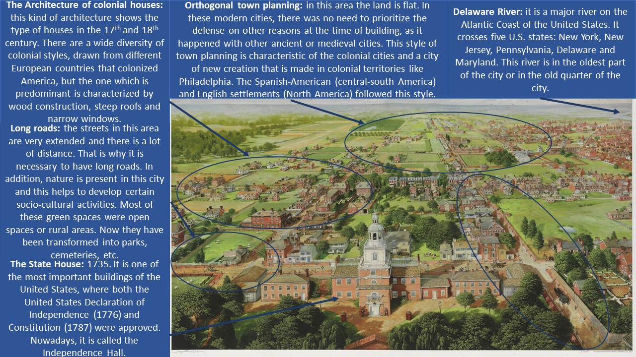
LOGROÑO (Domingo Muñoz, 1879)

GEOB2-Sanchez-Bacaicoa

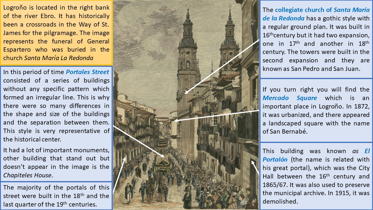
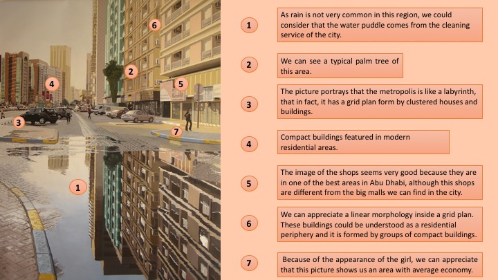
This etching was made by Domingo Muñoz (1850-1935) who was a Spanish painter and illustrator. The drawing was published on 22nd January 1879 in the newspaper “La Ilustración Española y Americana”. The article, where the print was published, describes the funeral of General Espartero who was buried in the church Santa María La Redonda. Nowadays the original drawing is in the Library of La Rioja, in Logroño. This picture represents a famous street of Logroño, the Portales Street (which was known in this period as Mercado street) in 1879.

Logroño is in the north of the Iberian Peninsula and it is limited by the Ebro river and the foothills of the Iberian System. Due to The Way of Saint James and the Fuero (when Alfonso X gave to Logroño the title of city), Logroño was transformed from a small linear village to a walled city that controlled the Ebro River. The wall defended the city, but over time, it caused the increase of urban density. The 19th century was the last moment in history when the walls had so much importance in Europe in milestones such as the War of Independence, the Carlist War and the disentitlement of the Church properties. These events influenced in the urban layout and in some important buildings of the city.

Since 1833, when Spain was divided into provinces, the Province of Logroño existed (with the capital in the city of the same name) forming part of Castilla la Vieja. When this happened, the population of the city of Logroño doubled his size. This caused the growth of the city and the construction of bridges, wine cellars and other important buildings. As a result of thi, in the 19th century, they built up the Ensanche which downplayed to the historical center. It was organized around El Espolón square and it grew up in every direction except the north. It was also adapted to the orthogonal axis produced by the exits to Zaragoza and Soria. The railway line (1863), which nowadays is the avenue Gran Vía Juan Carlos I and Jorge Vigón, formed the other limit for city expansion.

We need to consider that Logroño was surrounded by a wall until 1891, when 126 square meters were demolished to connect the High Street to the Muro de la Penitencia. During the 19th century the city was divided from North to South by the Ancha Street (known now as Sagasta Street) and from East to West by the Portales Street. At the street of this print famous livestock and trade fairs as the Feast of St. Barnabas took place; there were also bullfight festivals and medieval tournaments of jousting.

Portales Street had been a place where lived the rich people of Logroño. This was because it was a centric area very near to the most important places such as the market and the church. The importance of the street and their portals made them a typical area to pass through, but also because there were market stallsin the arcades. We can also mention three buildings which stood out, all of them were in the same side of the road: the Chapiteles House, El Portalón and the church Santa María La Redonda.

The Chapiteles House was built in the 16th century to be a manor house, until 1862 when it became the Town Hall. This cause a lot of changes in the Portales Street such as the demolition of the post office and other buildings. The previous town hall was El Portalón which was a building located in the same street, with three floors and a coat of arms in the façade. They finally changed the place because it became too small to preserve the municipal archives.

The most important church of Logroño is Santa María La Redonda that has got the main portal in the Mercado Square and two lateral doors in the Caballería and Portales Street. At the end of the 12th century, it was a Romanesque church of circular plan. But in the 16th La Redonda was rebuilt with many changes, it was formed by three naves with the same height. In the 17th the temple had an expansion by their head and another one in the 18th by the end of the church.

We should mention that in the past the lifestyle of Logroño was very influenced by the monasteries, but it changed with the French occupation (1808-1813) when the main religious buildings were used by the army, other suffered looting and were burned. But also with the Mendizábal disentitlement, many religious buildings were demolished and sold. Thus, this picture shows a modern representation of the bourgeois liberal society of the 19th century.

Isabel Sánchez Bacaicoa

Guardar
Guardar
Guardar
Guardar

04/29/17

VERONA (Caspar A. Van Wittel, 18th Century)

Verona. Lucía Plaza Suarez

This work of art belongs to the city of Verona. Its author was the Dutch painter, Caspar Van Wittel, commonly known as Vanvitelli (1653-1736). Van Wittel moved abroad form the Nederland’s to Rome with his family and spent all his life there. This is the reason why most of his artworks represent Italian sites, like the one we are going to work on. The picture entitled A View of the River Adige at San Giorgio in Braida, was made during the first decade of the 18th Century, and as we can appreciate, it represents the Adige River next to the church of San Giorgio in Braida. Nowadays, the picture owns to a private collection.

The image portrays some details, with pastel colours, about a typical day in the city of Verona in the 18th Century. The first thing we can appreciate is the Adige River and its two shores. Both riversides are plenty of diverse types of buildings from dissimilar periods which show the variety of art styles that have influenced Verona. According to the proximity between the buildings and also, the way they are surrounding the river, we can say that the city follows a nucleated pattern. We can not see very well the urban layout, but having into account some details, like the presence of some monuments such us the Medieval City Wall, we can guess that it was an irregular morphology. The structure of the city is divided in three parts: the left one is very compact and the buildings are clustered; the opposite side is older so the types of buildings are more degraded; finally, in the background there is a strategic place, which is in the hill of the mountain to control the river.

Broadly, we can distinguish between Medieval monuments, as the City Wall, Romanesque style in San Piettro´s Castle and some Renaissance impacts like San Giorgio in Braida´s Cathedral. Probably, the part that we are going to analyse belongs to the primitive settlement of Verona, but, as every city, it has been growing distinguishing between the left side, which belongs to the newest part of the city, whereas the opposite one owns to the oldest in those years. However, when we look at the picture, the Adige River catch our attention. It is important to stand out that point, because it entails a fundamental aspect of the location of Verona. Since the Ancient Ages, human settlements were stablished close to the rivers to provides people water and food. That’s the reason why the houses are along the riverside.

This painting also allows us to talk about the characteristics of the environment. We can see some people in the foreground, very useful to know about the typical clothes and the social activities of the 18th Century. Finally, we can talk about the means of transportation. The common one was the horses and the carriages, but it is important to highlight the gondolas, which are the main transport in certain Italian cities. This kind of ships were used to transport people in general, but it also was applied to services such as the trade. This is connected to the economic sectors: the first sector is present in activities such as fishing in the river or agriculture probably done in the fields of the background, the second sector is linked to the construction of the buildings and the third one concerns trade and transport. Another curious fact to note is the proximity between the City Wall and the buildings, which indicates that the city has been growing. Its function was to ensure protection and security to the citizens. The location of San Piettro´s Castle, also, fulfilled a very relevant task related to this issue. The high of the hill where it is situated, allowed the inhabitants to control the Adige river  and avoid possible attacks.

Lucía Plaza Suárez

Guardar
Guardar

04/28/17

VÄXJÖ (Erik Dahlberg, 17th Century)

Växjö engraving 1

This image is an engraving of the city of Växjö in 1690-1710 made by Erik Dahlberg that could be found at his publication Svecia Antiqua et Modierna. Erik Dahlberg was an engineer, soldier and Swedish field Marshall, who started to name himself Jönnson once he was made a knight. His work Svecia Antiqua et Modierna is a collection of paintings and drawing of Swedish castles and cathedrals, made by himself and published in 1698. Now it is preserved at the National Library of Sweden.

Växjö is a city in the middle of Smaland, in the south of Sweden, that today has a population of 60,200 habitants. The origin of the name is based on the location of the city and it means «road between lakes». Växjö has four lakes, the main one is Växjösjon and the river that flows into it is the Mörrumsan river; also the lake drain into Sodra Bergundasjön river so the ancient city was completely bordered by water.

In the engraving, it can be seen the Växjösjon lake and the cathedral of the city, which is so close to the shore. The cathedral was made in the middle of the 12th century but it has been renovated after 2 fires, although there are some pieces of Vikings ages. Today the Växjö domkyrka maintain the characteristic two towers from the 12th century even the renovation changed the general style into the Imperial one. The original church was formerly located in a peninsula, but the surrounding lake has lowered, so the cathedral is now surrounded by a large, green and inviting park area named Linnaeus park.

Close to Växjö domkyrka we could appreciate the Gymnasium or high school. Following its educational inspiration, today the city has one of the most important univeristies in Smaland, the Linnéuniversitetet. In the engraving we could also appreciate the Summer Castle of the Swedish crown. It was built at the end of 1300 but because of the fires and invasions, the style of the castle has changed to neoclassical. It is worth mentioning that in the near square there is a little market every Wednesday to be sold a lot of typical products from the area. 

The morphology of the city is orthogonal after the renovations occured in the Imperial era. A new structuring planning forced this morphology and obey to reconstruct some buildings into a modern architecture. Nowadays the center of the city is moved in to the proximities of the railway station and the Town Hall, which is located close to the Summer Castle. The richest area was the closest to the castle and the church, and has diferences between the type of houses, in the poorest area were smaller houses as it is seen on the left part of the picture and the richest on the right which seems looks bigger than the others. But today the center of Växjö is just a commercial and business district, and the different neighborhoods are close to Linnéuniversitet, Trummen lakeand Linneparken, and the train station in where is located the most important residential quarters.

Thanks to the proximity to the lake, the main activity in the city was a very important commerce between Sweden and Denmark, especially when the Växjösjon was freeze in the winter months. Also, it is needed to mention that the geographical location and the influence of nature made this city one of the greenest of Europe and an ecofriendly city in where the technology and all the resources are totally respectful with the environment.

Sara García

Guardar
Guardar
Guardar

04/27/17

SAN VICENTE DE LA BARQUERA (Javier Ibarrondo Los Arcos, 2013)

GEOB2-molina-serna

This work of art belongs to Javier Ibarrondo los Arcos and it was created in 2013. It is an oil on canvas painting and represents the city of San Vicente de la Barquera (Cantabria), located in the north of Spain, next to the province of Asturias. The painting was taken from the website Artelista.com. It has been depicted by looking at the city from the port and with the ships right in the foreground. The artist truly represents the fishing character of the city.

The city had a population of 4,344 in 2013. The climate is soft and, generally, hot and moderate. It rains more in the winter that in summer and the annual average temperature is 14.4°C. Some definitive factors that influence where the city was originally built are: the proximity to the water, as the estuary has developed a fishing activity and the port is one of the most important ones in the Cantabrian sea; the amount of vegetation, as we can find the Oyambre Natural Reserve in the proximity; the topography, because the hill surrounded by the river facilitates defense, etc. This place also takes part of the Camino Lebaniego, which connects the coastal route of the Way of Saint James to the principal French route. As a remarkable fact, San Vicente de la Barquera turned into one of the Four Villas of the sea of Castilla in 1330. This means to be a port enclave that allow the exit to the sea from the Central Meseta.

In the image we can appreciate that the city has an irregular urban layout. The hill follows the typical characteristics of a medieval settlement with clustered houses and narrow streets. It is clear to see the urban structure that is divided in two parts by the estuary. The old quarter is located at the top of a limestone crag, and it is surrounded by a crenellated wall and several gates, where two emblematic buildings stand out.

The first one is the Church of Santa María de los Ángeles, located in one of the highest points of the old quarter, in a square protected by low walls. It has 3 gates, naves with larger space, slim pillars and pointed arches. All this give the temple a monumental character. Here we can find a funeral piece of the inquirer, and it is one of the most interesting ones of this period in Spain. It has been attributed to Juan Bautista Vázquez.

The second monument is the Castle of the King, which was built in 1210 after the concession of jurisdiction for Alfonso VIII. It counts with two towers, one with a pentagonal plant and the other one with a square plant, joined by a rectangular court of weapons. From this castle there were departing the walls of which still have nowadays some sections. It is placed on a rocky mound that provides a defensive aspect, very typical among the buildings of that time.

There are other interesting buildings, such as the House of the Inquirer Corro, nowadays the Town Hall, with a Renaissance trace, and the Former Hospital of the Concepcion, now in ruins, with a beautiful façade. In addition, it is important to mention the High Street, crossing the Bridge of the Maza and then turning to the left, as well as the irregular, narrow and steep medieval street along the old quarter. On the contrary, outside the walls there is the modern town following a grid plan. Today the main economic activities in this village are fishing and tourism. San Vicente de la Barquera offers several beaches and attractions for visitors so that tourism is one of the most important activities nowadays. 

Noelia Molina Serna

Guardar
Guardar

04/26/17

ES CASTELL, MAHÓN (Jean-Baptiste Martin le Jeune, 18th Century)

Diapositiva1

On May 20, 1756, Menorca witnessed one of the greatest naval battles in its history; Britain and France fought to control the island. The French had already invaded the island and the only part resisting was the Castle of San Felipe, under the British in control. This picture, made by Jean-Baptiste Martin le Jeune (1700-1778), represents the attack and capture, on the French side, of the castle. It was on June 29, 1756, when the capitulation of the British took place and Menorca ended up belonging to France. The image is located in the Palace of Versailles as a testimony for political propaganda.

The Castle of San Felipe began to be constructed in 1554 to defend the port of Mahón from the attacks of Turks and Berberis. That menace was very common in Western Mediterranean during Modern Times, concretely after the Barbarroja assalt to Mahón in 1535. In the year 1558, the fortifications of the castle were already armed and in order to repel the Ottoman attack. That perception of defense stimulated many inhabitants to live near the walls of the castle and finally formed a permanent urban nucleus that, over the years, grew and was known as the Arrabal de Sant Felip.

Because they were too close to the fortifications of the castle, during the conflict with France in the 18th century, the place was devastated and the population moved further away, to Raval Nova. The new urban nucleus was founded in 1771 by the British with the name of Georgetown in honour of the King George III of England during the period in which Menorca was under British dominion. This is possible to appreciate by looking at the figure of St. George killing the dragon in the coat of arms. When the island was recovered by Spain in 1782, it turned its name to Real Villa de San Carlos in honour to the king Carlos III of Spain, later abbreviated to Villacarlos. Due to its geographical situation, it is the first municipality of Spain to watch the sun rise, being, therefore, the true Spanish uprising. Today Villacarlos is a municipality of the community of the Balearic Islands, located in the east of Menorca, at the mouth of the port of Mahon. Its current name is ‘Es Castell’.

The urban area that appears in the image represents s’Arrabal de Sant Felip, the old urban core of which nothing remains. It was based on an orthogonal or reticular plan, and it offers a very simple layout with perpendicular streets and a spacious square of arms in the center, surrounded by barracks. This type of urban layout was common in any colonial foundation, since the Roman times.

The Castle of San Felipe is one of the first strongholds star fortress of Spain, that is to say, bastions with «walls of curtain» that had the shape of a pentagon and two flanks. Its floor was square, with four bastions joined by four curtains, surrounded by a narrow and deep moat excavated in the stone. When the Britons of Menorca were possessed, the castle was greatly enlarged with lunettes and revellines united by subterranean galleries that shaped its starry shape. The castle was flown by order of the Spanish government in 1782. Many of the castle’s ashlars were used for the construction of a Lazareto (Sanitary enclosure dedicated to the observation and treatment of disinfection of people who may be carriers of a contagious disease) that can still be seen in the homonymous island. The Lazareto of Mahón was constructed in 1793 by order of the Count of Floridablanca, minister of Carlos III. It is currently a holiday residence of the Spanish Ministry of Health and Consumer Affairs.

Years later, after the demolition of the castle, in 1852, La Fortaleza de la Mola was constructed during the reign of Isabel II. It was built to protect the entrance to the port from the other side of the mouth, as a defense mechanism against the possibility of a British invasion, interested in recovering the island due to its strategic geographical location for trade routes and to overthrow France. The building itself is impressive and one of the most advanced military works for the time. This fortress is also one of many testimonies about the interest in dominating the island throughout the history of Europe. Although destroyed, you can still visit the ruins and part of the underground galleries of the castle, still impressive enough to give an idea of ​​what San Felipe was in its best moments.

Some factors that have a vital importance for the economy are the cattle raising and the manufacture of cheese with denomination of origin «Mahón / Menorca» (Cheese of Mahón), as well as footwear industry, leather goods and skin in general, jewellery, bakery, charcuterie and other small industries that form the second pillar of the economy, which is much more remarkable than on other islands and an alternative to tourism. In addition, Menorca was declared a Biosphere Reserve in 1993 because of its high degree of compatibility between the development of economic activities and the conservation of its natural and historical heritage. The favourable environmental and geographical conditions that the island has a great potential for self-sufficiency with renewable energies.

Laura de la Peña Aguilera
Guardar
Guardar

04/26/17

PALMA DE MALLORCA (Antonio Garau, 17th century)

Diapositiva1

This work of art is an anonymous oil painting displaying the city of Palma de Mallorca in the 17th century. It was 300 years in a room next to the Plenary Hall of the Town hall of Palma and a few years ago it was transferred to the museum of Bellver. It is an oil painting on canvas by author and unknown date. According to some research, still unfinished, possibly the date of oil painting is between 1647 and 1650 and perhaps this was painted by Marc Corró. In the oil painting two characters are represented; the first one is Ramón Llull, Mallorcan who lived between 1232 and 1316, and was a versatile writer who expressed in Latin, Catalan and Arabic, and the other personage is Catalina Thomas, a nun born in Mallorca and Saint of the Catholic Church. Also appears the shield of Mallorca and a text that says: “In the Balearic government celebrated the 8 of November of 1799 this oil painting was compared with another engraving in the year 1644, that realized Antonio Garau, mathematician and seeing that they were quite equal agreed the City Hall this note to know who can be its author”.

In 1997, the city council of Mallorca thought it was appropriate to investigate the data in the table. Twelve years earlier, it had been restored and compared by reducing the scale of the oil painting and overlapping it in such a way that the enclosure of the city wall fits with the map of Palma de Mallorca made by Antonio Garau in 1644 who was a presbyter, mathematician, teacher and canon of the Cathedral, and died in Palma in 1657. This map represents very in detail the walled city, together the shield of Palma and a list with the 46 most important buildings and places. The conclusion was that Garau’s map was used to make this oil painting, or the other way around, that this oil painting was used to draw Garau’s map.

The city of Palma is located in the center of the bay of Palma. The island of Mallorca lies in the middle of the western Mediterranean off the coasts of the Iberian Peninsula. The picture shows that the main economic activities are agriculture, due to the large extensions of cropfields, and trade because of its strategic location in the Mediterranean Sea. Another notable area is the military activity, whose mission was to defend the city from outside attacks.

As we can appreciate, the only water stream that appears in the oil painting is the Riera. This sort of river passes now through the Ramblas, Union Street and Paseo del Borne, but in the 17 th century was diverted so that it did not cross the old town. In the image, we can appreciate the different areas such as the center of the city that has a radial distribution around a central square where the streets meet. The southeast zone has a more regular layout because the streets have right angles. The rest of the areas have an irregular, chaotic morphology, because the streets do not follow a previous order and they appear disorderly, being frequently narrow, sinuous and twisted, with dead ends and closed alleys. We also observe in the map that the irregular plan predominates respect to the others, although there some axis delivered in a radial way.

In addition, the picture shows that the city is separated by a long road that leads to the port from north to south. It was in the port area where the most populated places were situated, thanks to commercial activities. The city is also surrounded by a city wall that was designed in the form of triangles where the cannons were placed so much to attack as to defend against the artillery. The city wall separates Palma de Mallorca from the sea and continues closing the perimeter of the city, whose purpose was to protect its inhabitants and defend it from external aggressions.

The rest of the land outside the city was dedicated to the forestry and agricultural sector, which was divided into open field (large tracts and was managed by the upper class) and enclosed field (small plots that worked the poorest classes). Also, in the outskirts we can observe plots, extensions of land, mills, etc. The main crops were olive, vine and cereals, while in the livestock sector sheep herds stand out. In the foreground, you can see the Mediterranean Sea with many boats around the city. During the 16 th and 17 th centuries, agriculture was the economic and productive base of Mallorca, because its economy was based on a system of autarchy that concentrated a large part of the population employed. To summarize, the primary sector (agriculture, livestock, commerce and fishing) was highly predominant.

It is curious to note that the city of Palma was originally occupied by a Talayotic settlement. Later in 123 a.C. it was invaded by the Roman consul Quintus Caecilius Metellus. The remnants of walls and important buildings (an amphitheater, for example), affirm that the Roman Palm was in the high part, around the place of Cort. Subsequently, the island of Mallorca was occupied by Vandals and Byzantines. Later, in 903, the city was conquered by the Arab general Isam al-Jawlani; from that time we conserve the Royal Palace of the Almudaina, the Arab baths and the Arab city buried under the present city. The first certified name of the city is the «Madina Mayurqa» of the Arabs. An historical event that took place in 1229 was the conquest of the city by King James I of Aragon, who namet it Ciutat de Mallorca. This is the name the city would have until the Spanish Succession War. As a remarkable fact, Mallorca was the last territory to surrender before the army of Philip V of Borbon, on July 3, 1715. We must mention that one of the acts approved by Philip V was to change the name to the capital «Ciutat de Mallorca» for «Palm».

Concerning its economic activities, the geographical location of Mallorca allowed an intense commerce with the towns of the Maghreb, Italy and Turkey. In the Lonja was an active market supervised by the Consulate of the Sea. Nevertheless, at the beginning of the 16th century, the plague, rebellions and attacks of Turkish pirates led to a reduction of commercial activities and the city entered into a period of decline that lasted until the end of the 17 th century. Most of the medieval guilds, such as fishermen, silversmiths, surgeons, tailors, butlers, blacksmiths, etc., were located between the old town and the port area. The rest of the occupations, such as millers and farmers, was located in the periphery. As for religion, in the 17th century Catholicism predominated throughout the island and other religions were discriminated and marginalized.

To finish with, we can mention the most prominent places to be appreciated in the map. In the foreground is possible to see some monument as Santa Maria Cathedral, La Lonja, El Consulado del Mar and La Almudaina. On the right side, we can distinguish the Arab baths and the towers of Gumara, another important monument that does not appear is the Bellver Castle and the cathedral is the most outstanding monument of oil painting.

Alexandra Villegas Almazán

04/26/17

PHILADELPHIA (Paul MacWilliams, 1776)

Diapositiva1

This painting is called “Pennsylvania State House in 1776”, by Paul MacWilliams, a 20th century realist painter. He has a degree in illustration from the Philadelphia College of art and he used late century 18th Philadelphia prints, maps and other visual resources to study the landscape of the city. This view shows the Independence Hall, what was called Pennsylvania State House before. The author also read a John Fanning Watson’s book named “Annals of Philadelphia” to understand better the life in the colonial city and spent a lot of hours researching at local repositories including the Library Company of Philadelphia. I have found this painting on a website of a gift shop in the state of Pennsylvania called Beauty Art, Gifts & Décor. In this shop we can also find other paintings from other painters.

The picture is an oil on linen 50×70. It depicts the artist’s research and interpretation of what the city of United States’ birth looked like in 1776, when that country declared its independence from the United Kingdom of Great Britain. Philadelphia is probably one of the most historical cities of United States.

We can find Philadelphia in the east coast of the USA and on the north American continent, next to the Atlantic Ocean. This city is also located at the confluence of the Delaware river and Schuylkill river on the eastern corner of Pennsylvania state. The Appalachian Mountains goes to the west and the Atlantic Ocean to the east. This city and this area too are usually involved by the ocean air and it brings high humidity.

The economy of Philadelphia has changed substantially throughout time. In the 17th and 18th century, this city grew as a major Atlantic seaport, receiving, processing and shipping flour, meat and forest products. Gardens were very common in the 18th century, where fruits, vegetables and herbs were grown. The farmers bought many of the other food on market day and they set up stalls to sell their wares on High Street, which is nowadays an important market in Philadelphia. Meat was also hunted in the closer woodlands.

Besides, in the early 18th century there was a great religious revival in the North American colonies. Churches came up in all shapes and sizes and they reflected the customs and traditions, as well as the social status of the denominations that built them or even the wealth of the neighborhoods.

This city presents an orthogonal town planning, because in this area the land is flat and in these modern cities, there was no need to prioritize the defense on other reasons at the time of building a city or no need of fortification, as it happened with other ancient or medieval cities. There was not either need of having defensive walls or fortifications. They first built up the streets and then built the houses and that’s why there is plenty space between one house and another. This type of town planning is characteristic of the colonial cities and a city of new creation that is made in colonial territories like Philadelphia. The Spanish-American (central-south America) and English settlements (North America) followed this style.

Philadelphia is also closely linked to nature and we can see that there are many green areas which are close to the houses. Thanks to these green areas, this city could deliver certain socio-cultural activities that favor agriculture or even livestock. We can find in the painting some farms with some cows and livestock animals inside them. Most of these green spaces in those years (18th century), were open spaces or rural areas. Nowadays, with the growth and development of Philadelphia, they have been transformed into cemeteries or even parks.

The closest area to the Delaware River can be considered as the oldest area, which is called the Old Quarter. The different areas of the city newer than those that were next to the river, were growing and extending throughout the territory over the 18th century, like the State House or the Independence Hall district. These areas are considered of new expansion and form what we now know as the modern city of Philadelphia.

In those times there was a high pressure between Great Britain and the colonists. This pressure led to Independence War. It was extended from 1775 to 1781. The first Continental Congress met in Philadelphia in 1774. The second one also met there in one year later. Then in 1776 the Declaration of Independence was written down by Thomas Jefferson in Philadelphia, 4th July. Since this day, the Americans celebrate the Independence Day of the United States. The Independence Hall, previously called The State House, was built between 1732 and 1753 by Edmund Woolley in Georgian style in this place the Declaration of Independence was written down by Thomas Jefferson in 1776. The Georgian style is characterized by its square and symmetrical shapes, central doors and straight lines of windows on the first and second floor.

On 26 September 1777 during the Independence War British troops occupied Philadelphia. However, they did not hold it for long. The British withdrew from Philadelphia on 18th June 1778. The Constitutional Convention was held in Philadelphia in 1787. The First United States Bank was built in 1797 in Philadelphia.

Alejandra Echevarría Esteban

04/26/17

VERONA (Bernardo Belloto, 18th Century)

Diapositiva1

This work of art is an artistic painting of the Italian urban landscape painter Bernardo Belloto. Bernardo Belloto was an apprentice in his uncle’s workshop. In 1738 he was enrolled in the guild of painters. Along his life he represented many cities until being recognized as a master of perspective. This masterpiece was taken over the Adige River of Verona between 1745-1746 and shows several places of the Italian city of Verona. This work of art is painted with oil on canvas and it is currently in the Philadelphia Museum of Art.

Verona is located in the North of Italy over the Veneto region. It is the biggest and most prosperous city of the region. It is bordered by Adige River and it is strategically connected with Central Europe due to Brenner Pass through the Alps. Besides being an important crossroad, its history has been highlighted because of knitting, paper, machinery and footwear production. At least, its economic sources have been —besides previously named— the craftwork and trade. Cause of the benefit of these communication roads, Verona turned into a Roman township loved by politician and general Julius Caesar, as well as the architect, writer, engineer and treatise writer Marcus Vitruvius, the historian Gaius Valerius Catullus, and many others. The city construction was focused around this stretch of the river and it turned out in an important source of economic activities like fishing. In the 18th Century there were a lot of fish population, especially, the trout. Moreover, as the painting shows, in the right side appears not building areas in which Verona citizens performed these economic activities but, nowadays, this area has been built and its natural zones have been changed by other buildings.

Previously called San Martin Castle, in the centre of the painting we could find the Corso Castelvecchio. Because of Verona was a strategical city and it received so many attacks, Castelvecchio was built in 1354-55 by Cangrande II della Scala for internal and external protection —especially on the west side—. Years later Napoleon built a fort in the Castelvecchio’s courtyard. Of a time to this part, Castelvecchio has been restored. The first restoration was among 1923 and 1926 when Napoleonic fort acquired a new architectonical aspect. The next restoration was among 1958 and 1964 when the castle recovered its original form in several places. And the last and very recent restoration was finished in 2007. This restoration has improved the capacity of touring the castle through its 27 artistic rooms.

Nevertheless, on the left part we could find San Zeno in Oratorio Church. This church was made in Romanesque style but the facade represents a posterior type of architecture: the Gothic one. Also the painting represents a bridge which is a perfect masterpiece of medieval engineering. It is called Ponte Scaligero (Scaligero Bridge) and it was destroyed in some extension. This bridge is part of Castelvecchio and also was built with military objectives in the middle of fourteenth century (1355 A.D.).

As a Roman city, Verona is based on a regular morphology. Verona citizens took advantage of Adige River for better protection. In the 18th century, the current “historical centre” is the part compound of castles, churches, etc., where lived main powerful people and the poor and peripheral area was the right side of Adige River. In time, the old city of Verona has increase their urban areas so their structure has been enlarged. However, their small historical centre which has inspired so many dramatist, like William Shakespeare with his “Romeo and Juliet”, maintains the charm of centuries behind.

 Víctor Lizana Muñoz
Guardar
Guardar

04/26/17

VERONA (A. H. Payne, 1852)

GEOB2-martin-gil3

This engraving, made in 1852 by A. H. Payne, shows the city of Verona in the 19th century. In the image we appreciate some buildings of the city of Verona, the Ponte delle Navi, which crossed the navigation channel of the river Adige and some rowboats. At the bottom right we can also see the church of Santa Anastasia.

Verona is a city located in Northern Italy and is the capital of the province of the same name, one of the seven ones in the Veneto region. The city is situated at the foot of the Lessini Mountains on the River Adige. It is surrounded by hills and trapped by a meander of the river Adige, about 30 kilometres east of Lake Garda. Its origin is very old, probably inhabited from the prehistoric times by a population which is difficult to be identified: they could be the Etruscans or the Paleovenetos. From that date, all the towns that alternated in the control of the zone, always did it by the presence of River Adige, that was considered like the best place for a settlement. Thus, Verona is an important geographical node. It has always been the nodal point of all the terrestrial and aquatic transport systems in Northwest Italy. In Roman times it was a meeting point for four consular routes: the Gallica road, the Via Augusta, the Vicum Veronensium and the via Postumia.

Regarding its urban structure and architecture, Verona is an outstanding example of a town that has developed progressively and uninterruptedly over 2,000 years, incorporating artistic elements of the highest quality from each succeeding period. It represents an «outstanding example of a military fortress», emphasizing that it has preserved a remarkable number of monuments of Antiquity, Medieval and Renaissance periods.  The walls surrounding the city prevented the 19th century development such as industry and railroads within the historic city. As a result of this, the urban structure shows an exceptional coherence and a large degree of homogeneity. The original Roman urban form continues to be evident in the existing street pattern and the city historic fabric remained intact until World War II. Surviving evidence of the fortified town, such as Roman gates and Renaissance bastions, reflect this long military history. 

It is still possible to distinguish the medieval city centre, even though it contains more recent buildings (from the Renaissance and the eighteenth and nineteenth centuries), the Veronetta and San Zeno Districts, entirely composed of buildings from the low medieval period. On the other hand, some areas outside the walls are characterized by villas and buildings constructed in the Baroque era. Finally, there is an industrial area named Borgo Roma, built in the turn of the last century, and the modern city, which developed without effecting this urban structure inherited from previous periods.

Among the most important urban elements that we can find in the image we can highlight the Ponte delle Navi that appears in the centre of the engraving. This bridge of three arches covers the river Adige and possessed a fourth lower arch that covered the canale dell’Acqua Morta. This bridge was damaged and rebuilt several times due to the floods of the river Adige and the bombs dropped by the Germans in World War II. The bridge, with its three arches, covers 90 meters, and has a width of approximately 12 meters. Another very important element that we find is the river Adige that runs through the regions of Trentino-Alto Adige and Veneto and flows into the Adriatic Sea. It has a length of 409 km that make it the 2nd longest river in Italy. To save the city of Verona from possible floods, in the first half of the twentieth century a tunnel was built connecting the Adige on its way through Mori and Lake Garda, in order to direct the surplus water from the river to the lake. The last of the most important elements that appear in the photo is the church of Santa Anastasia, which is a temple of Gothic style and is located in the historical centre of the city, near the river Adige. Its construction began in 1290, but never finished. It is thought that the project was carried out by Fra ‘Benvenuto da Bologna and Fra’ Nicola da Imola, but no documents have been found to confirm this. The church of Santa Anastasia was built on a pre-existing one dedicated to the same female saint, reason for which it was called thus, although in origin it was dedicated to San Pietro, a Dominican martyr assassinated 4 of April of 1252. The consecration Of the church took place only in the year 1471.

In the Renaissance the city was part of the Republic of Venice, sharing its splendour in art and social life. The great families of the nobility and the new mercantile bourgeoisie enrich the city with gardens, buildings, villas and churches,  promoting economic, social and artistic development. With the fall of the Republic of Venice and the arrival of Napoleon, Verona and its territory become strategic points in the international scene and in the scene of numerous battles. During the first half of the 19th century, Verona formed a military stronghold of the Austrian empire, and in 1866 it became an Italian city.

Miguel Martín-Gil

Guardar
Guardar

04/26/17

SIENA (Vincenzo Rustici, 16th century)

GEOB2-Sánchez-del-Saz
This work of art was painted with oil on canvas by Vincenzo Rustici (1556-1632). The city which appears in this painting is Siena, a city which is situated in the region of Tuscany (Italy). The image represents the moment when the parade of the seventeen neighborhoods is been performed around Piazza del Campo during the festival of Il Palio. It is preserved at the San Donato Museum in Siena.
Siena is situated in the region of Tuscany. It is located among three hills in the North Arsia valley, home of the wine Brunello di Montalcino. In the north of Siena, they can find Elsa where there are olives and vineyards, which are for the famous wine “Chianti”. There is not any river in the surface of the city, but there is a legend telling about an underground river whose name is Diana. Because of being surrounded by olives and vineyards, the main economic activities are related to agriculture and commerce. Apart from this, Il Palio attracts many people for tourism.
Siena has been adapted to a difficult topography that has impeded urban growth and has kept the city within a medieval atmosphere. Thus, the streets are narrow and there is a city wall that surrounds a big part of the town. Originally, Siena was divided in three quarters, but nowadays the city is divided in seventeen districts. The city wall protects the historical quarter and its function is defensive apart from spreading the water to water fountains. This wall has six gates and the most important is Camollia Gate which gives name to one of the neighborhoods, formed by six districts. Di San Martino is another area in the middle east of Siena and includes five districts: Civetta, Leocomo, Nicchio, Montone and Torre. This quarter receives this name from San Martino church, a very important pigrimage destination in the Middle Ages. There it is the historic center of the city and the Town Hall, in the Piazza del Campo. There are several streets departing from the piazza in a radial way. One of them leads to the Duomo or Cathedral, made in the 14th century,that is one of the most importat monuments in Siena. It is in the Piazza del Campo where the festival of Il Palio is celebrated twice a year, as it is shown in the picture.
The political importance of Siena has diminished over the years. During centuries, Siena was the most important city of Tuscany but as the years passed, the internal struggles between aristocrats and common people made that Siena lost its political importance in favor of Florence. This struggles were produced because aristocrats wanted more territory and kicked out common people. Apart from this, the differences between rich people and common people grew steadily and this produced more struggles. An anecdote of this struggles is that when people was going to fight, they prayed to virgin Mary; that shows the importance of religion in the Middle Ages.
In the picture, we can appreciate a few urban elements that are the most important of Siena, such as the Mangia tower, which is the bell tower of the Palazzo Pubblico, and the Palazzo Pubblico itself, which is an exemplary of Gothic secular architecture. This bulding was the Town Hall since the 13th century, when the nine-government ruled in Siena, but nowadays it is a museum too. The Duomo is one of the most important cathedrals in Italy and has artistic treasures of Bernini, Donatello and Miguel Angel. Santa María della Scala is important too because it was one of the oldest hospitals in Europe and nowadays there are a lot of museums inside it. In conclusion, Siena has not changed very much and is really similar today as it was in the Middle Ages. Its historical center with the Piazza del Campo deserved the consideration as a World Heritage site by UNESCO.
Pablo José Sánchez del Saz
Guardar

04/26/17

ABU DHABI ( Francisco Motto, 21st Century)

Diapositiva1

This work of art was made by a famous artist from Spain called Francisco Motto. It represents a modest area of Abu-Dhabi. The author was born in Madrid in 1945, lived in Monzón until he was 29 years old. Motto practices a type of painting that approaches the hyperrealism of current frame, personal composition, linear perspective and balanced colour and composition full of difficulties. The most typical landscape that predominates in his paintings are urban spaces and interiors.

The chosen city is on the north-eastern part of the Persian Gulf in the Arabian Peninsula. The climate is so hot, because of the desert, as well as we can observe blue skies throughout the year. Abu Dhabi´s rapid development and urbanization, coupled with the relatively high average income of its population, has transformed the city into a large and advanced metropolis. The architecture is lofty because of big gardens, mosques, enormous business buildings…

It could be said that the streets are laid out in a grid plan. The buildings in the picture could be understood as a residential periphery which were added in the second half of the XX century and it is formed by groups of compact constructions. This neighbourhood could be located in the suburban area of the city.

The image portrays the city of Abu-Dhabi with a great amount of details. It is a modest street in the suburbs of the city dedicated to quotidian activities like shopping, with cars driving across a big avenue. Both sides of the picture show us everyday nature far from luxury and opulence well-known in Abu-Dhabi. The bottom of the picture shows us high skyscrapers made of opulent materials and in the foreground we can see some buildings with a different morphology. On the right side there are various blocks of flats with different shapes and light colors, most of them with balconies.

There is a typical palm tree in the middle of the pavement which does not seem to match with the rest of landscape. That is the reason of the hot dessert climate with cool seasons from November to March, on average, January is the coolest month in the year, while August is the hottest.

The left part of the picture is divided in two sides, one a road with cars stuck in traffic, allowing access to the wealthy area visible at the back of the picture. The second one is a park line separating again the hustle and bustle of the quiet community. The strong point of the picture is the enormous puddle which capture all our attention due to the fact that the artist allows us to see better chromatic variety than the real image.

It is curious to point out that the image shows the less known part of Abu-Dhabi nothing to do with spectacular malls, cars and lavishness of the city, taking in count that Abu Dhabi´s government is looking to expand revenue from oil and gas production to tourism and other sorts of things which would attract different types of people.

Alejandra Gutiérrez Rodríguez

Guardar

04/26/17

CATANIA (Antonio Stizza, 1592)

GEOB2- Martín-Figueredo

The picture we are going to talk about was made by Antonio Stizza in 1592 and finally published in 1598, so it represents the city of Catania in the end of the 16th century.

Catania is a city located on the east coast of Sicily, Italy, next to the Ionian Sea. Catania is actually the capital of the Metropolitan area of Catania that is one of the biggest cities in Italy, and the second one in Sicily after Palermo. Catania was founded in the 8th century BC, as a Greek colony and it has been destroyed at least seven times because of the eruptions of Etna volcano and several earthquakes. It was also the first city of Sicily in having a university, that was founded in 1434 by Alfonso V of Aragón.

The Greek geographer Strabo said that the presence of the Mount Etna has bad and good things. On one hand, the eruptions of Etna caused a lot of suffering and destruction, but on the other hand the ashes made a fertile soil, especially good for the vines. Therefore, agriculture is one of the most important economic activities developed in Catania.

We must say that the city we know nowadays as Catania is not as the Catania that we see in the picture made by Stizza. First of all, in 1669 the city suffered the eruption of Mount Etna. The population was almost saved because the city walls stopped the lava and most of it diverted into the port. The eruption of the volcano was so terrible that even the Nicito lake, which was in the limits of the city, and had a circumference of around six kilometers was covered up with lava. The east part of the city was seriously damaged. What is more, in 1693 Catania suffered an earthquake that destroyed the city. Then, a big part of the city was reconstructed over the ruins of the old Catania, according to the Baroque architecture that nowadays characterizes it.

Catania has a subterranean river, the Amenano. When the Greeks founded Catania as a colony, they decided to establish their settlement there because it was at the edge of the Amenano river. After the earthquake of 1693 and the reconstruction of the city, the river was covered by the new city.

We can also see in the picture a clear example of a medieval city. As we can observe the streets looks narrow and disorganized. This is the result of a disordered growing. Another example that makes us think about Catania as a medieval city is the city walls. The city walls were important in those times because they were used for defense and, if someone wanted to introduce something inside, he was forced to pay taxes for it. In addition, the city walls stopped and diverted the progress of lava while the eruption of Mount Etna in 1669, as we said before. Nevertheless, the left part of the picture seems like having an orthogonal plan, maybe because the Romans established there a colony after the First Punic War until the decline of the Roman Empire in the 5th century.

One of the most important urban elements that we can see in the picture is the Cathedral dedicated to Saint Agatha, to be seen at the bottom. This Cathedral was originally constructed between 1078 and 1093, over the ruins of the Roman Achillean Baths, by order of King Roger I, who conquered the city from the Islamic Emirate of Sicily. However, the Cathedral was completely destroyed in 1693, as the result of the earthquake, so the Cathedral we can see nowadays is not the same because it was reconstructed in Baroque style. The bell tower was built in 1387 and it was 70 meters high. After the destruction of 1693 they added a huge bell of 7.5 tonnes, being the third biggest one in Italy.

The harbour is also is noticeable. It was was the main point for trading and getting new things that came from other countries. Greeks decided to establish there their colony because it was well-located, next to the Italian peninsula, and not so far away from Africa and Greece.

Another interesting place in Catania is the Castello Ursino that we can see in the left corner at the bottom of the city. It was built in the 13th century as a royal castle for the King of Sicily. After the Sicilian Vespers, the castle was the residence of Frederick III of Sicily, son of Peter III of Aragon who fought in the Sicilian Vespers against the French army commanded by Charles I of Anjou. The moat that was surrounding the castle was also filled up with lava after the huge eruption of Mount Etna in 1669.

Juan Martín Figueredo

Guardar
Guardar

04/26/17

QUEBEC (George Louise Le Rouge,1755)

Quebec

According to Earl Jodeph, D. This picture was done by George Louise Le Rouge in 1755. The drawing is about the views of Quebec from Saint Laurent river and shows some significant parts of the city. This is one of the oldest cities in North America, since it was founded by Samuel de Champlain in 1608.

Quebec is situated to the east of Canada, a region with a great variety of landscapes from the Appalachian to the Laurentian mountain ranges. concretely, it is located on the banks of the St. Lawrence River, it is the most navigable canal on the east coast of Canada and delivers various economic activities such as fishing, farming, mining, hunting and trade. Its historical walled center is named as Old Quebec, in French Vieux-Québec. The official language of Quebec is French although there is a small part of the English-speaking population. In addition, it counts on a population mainly catholic due to the time of the French colonization. Actually, the French colonizers had to be careful because of the serious rivalry with the British Company of Hudson Bay.

At the beginning, Quebec had a linear type of urbanism along the coast of the Saint Laurent river. In the image we can see different parts that form the urban structure of Quebec. We will begin by describing the fortress that is related to the letter A in the image. This one was created on a rocky cliff to allow the defense of the city before American attacks. The fortress nowadays is still in use and serves as the residence of the officer of the Governor General of Canada. Today it is possible to enjoy as a tourist the change of the royal guard. The citadel is organized as a sort of star over the Upper City. Thus the uneven plan with different heights, makes the plane of the city more irregular and therefore difficult to determine. Quebec is made up of narrow, rectilinear streets and around urban squares. In general, Quebec is divided in the Upper City, protected by a wall with bastions and whose functions are the administration and the cult; and a Low City that is composed of the port of Saint Laurent river. The first one is an example of a fortified colonial city, whereas the second one works essentially as a business district.

The most significant element of Quebec is the Chateau Frontenac, today part of a touristic resort. This hotel is one of the most striking architectural works created in 1893, which through its windows makes possible the vision of the green field where the battle between the French and English army took place. Another important building is The Seminary, created in 1633 by a religious vicar destined for the New France and in 1665 linked to the Seminary of the Foreign Missions of Paris. This institution was conceived as a “place of retreat, from which we can obtain and capable subjects to send them to all points according to the needs of the parishes and all other places of that country…”. However, the conquest of New France un 1760 caused the Jesuit school to be closed and to be used for teaching that would welcome all young people who wanted to being their academic education. Today it is a teaching institution in a position to respond to the expectations of a society that continues to evolve.

The cathedral of Notre-Dame Cathedral is another religious icons for Quebec. It is located in the town hall of the city. Not to mention the cathedrals of Mexico, it is one of the oldest religious buildings in North America. It was built in 1647 but was modified in 1843. The old design of the cathedral was by Jean Baillairgé, and the modification was made with the purpose of seeking the similarity with a Parisian church for that it emphasizes the neoclassical style in the facade . There was a restoration of it in 1922 since inside it began a fire that destroyed the basilica. It is currently considered a building of great importance and together with the Historic Center of Quebec are part of the World Heritage of Unesco.

Marta González García

Guardar

04/26/17

VERACRUZ (Adrian Boot, 17th century)

GEOB2-gomez-muñoz

This picture is a representation of the city of Veracruz, which is located in the east coast of Mexico, in the state of Veracruz. The author of the original image is unknown, as the image is not signed, although it is thought it could be a German engineer called Adrian Boot. This is because this picture has many similarities and a similar style with another representation of the Mexican city of Acapulco, which is, indeed, signed by A. Boot. This version is a chromolithography made in Florence in the year 1907. The exact date of the original version is also unknown, however, it is thought that it was drawn around the year 1620.

Veracruz is located in the east coast of Mexico, and it was the first city founded by European colonizers in Continental America. It was founded by Hernán Cortés through an expedition that took place in the year 1519. The first name given to the city was “Villa Rica de la Vera Cruz” (Vera Cruz meaning “the holy cross”).

One of the most remarkable elements that can be seen in the picture is the San Juan de Ulúa fort. This fortress was built in a small island next to the Mexican coast (island of San Juan de Ulúa), with the purpose of protecting the Spanish ships from the pirates. This was the first place the Spanish colonizers arrived to, and from here, they went on to the beach of what would be the city of Veracruz.

The city of Veracruz does not count with walls or barriers for protection it in the picture, even though there are documents and drawings that prove the city had defenses around the year 1590. This is because Veracruz was the objective of many attacks, given that it was the starting point of many ships loaded with gold and goods travelling to Spain. The pirate attacks were one of the main problems for the colonizers at the time, as they not only lost many of their goods, but the attacks usually ended up with rapes and assassinations.

Talking about the urban layout, there is a common characteristic every Spanish colonial city in Latin America. That is the grid plan; in other words, the streets are parallels and the buildings make square portions in between the crosses of the streets. Around the main street, which is in the central part, there can be seen the main buildings of the city, which are the churches and the “cabildo” (which can be compared to the current city halls). One remarkable characteristic of the city plan is the position of the port, given that it is far away from the urban part of the city, but with the intention of protecting it against attacks.

The outskirts of the city were destined to cropfields, barns, stockbreeding and other agrarian activities. Given the heavy catholic upbringing of the Spanish kingdom, the churches were one of the most important elements of a colonial city, as they were the symbol of the evangelisation of the land conquered by Spain. One of the most important ones is the convent of St. Francisco de Veracruz, which was built around the year 1580. It had a significant importance in the Veracruz port, as it was the place where the reunions between the sailors and the officers had to be hold.

Another significant building was the “cabildo”. The “cabildos” were the municipal institutions created by the Spanish colonizers to manage the cities. When a city was founded, the founder chose between its officers the most suitable to take the role of “alcalde” and “cabildo”. As it can be seen in the guide of the picture, they called them “casa del cabildo” (house of the cabildo).

The port of the city of Veracruz became, with the time, the opening door for the goods to travel across the Atlantic Ocean and into Europe. It became crucial, not only for Veracruz, but for other Mexican cities like Acapulco, Puebla or Ciudad de México, because it was the place where the exchanges between Europe and Continental America were made. The most significant materials found in Veracruz were gold and minerals, and this is one of the reasons why the city was initially called “Villa Rica de la Vera Cruz”.

Lucía Gómez Muñoz

Guardar
Guardar

04/26/17

CORUÑA (J. Cordine & J. Ximeno, 1792)

img blog

In this image called Bahía de La coruña by José Cordine and J. Ximeno (1792), we can see a fragment of the city of A Coruña in the XVIII century, where they appear the coast, the port, the Tower or Lighthouse of Hercules, the castle of San Antón and a settlement next to the coast. The historical origin of this city is dated in 1208, when Alfonso IX, king of Galicia and Leon, decided to build a new town near the lighthouse tower, for the usefulness of his kingdom. All the elements are strategically organized along the edges of the coast. Both sides we can appreciate castles or fortresses that serve for the protection of the city, placed in the centre.

Talking about the city, we can clearly see that it is preindustrial one with an irregular layout, and is divided into two different parts. The first one is the nucleus of the city, where houses are grouped irregularly and surely there are historical elements like a central square. The other part is situated along the coast and consists of the houses of the merchants or fishermen. In this case, the functions of the city determine its morphology and structure, considering that the seaside zone function was commercial and fishing, and that the function of the urban area was more related to residence and defense.

The coast and the port are two very important elements in the image since they represent the main form of commerce of the city in the time, maritime trade. The good Atlantic position of A Coruña favoured that it was an important commercial port that served as a stopover in the route from the Mediterranean to the North Sea. In the 15th century, the port of Cruña become the first port of Galicia, one of the most importants of Spain, and one of the main commercial ports in Europe; and its brand-new lighthouse was its international symbol of prosperity.

On the other side, there is the Tower of Hércules, previously called Farum Brigantium. Up to the Middle Ages, the city of Brigantium (whose name phonetically evolved from Brigantium to Breganzo and then to the medieval Betanzos) was the commercial and political capital of his territory, and the Farum Brigantium was the tower that watched and guided navigation at the entrance of its estuary. There are two versions about the origin of the Tower. The first is that of the Greco-Roman origin, which tells the story of Hercules as winner of Geryon (Gerión) whom he buries and over his head, so that his victory is remembered, he built the Tower. The second version is that of Phoenician origin, which defends Celtic culture and the legend of Breogán. The historians of this group admit that the present Tower is Roman, but that previously existed in that place another tower of Phoenician origin like guide or lighthouse (which appears in the legend of Breogán), and the Romans seeing its function, copied the idea and built the Tower that we still have today. Throughout the medieval period the main role of the Tower was to serve as a watchtower and stronghold at the same time. Its possibilities of point of observation and its defensive capacities could have turned it into a wanted good before the frequent incursions by sea, in spite of its semi-ruinous state. The city of A Coruña chose as a symbol of the city this Tower, that rises in front of the sea to more than 30 meters of height.

Finally, it appears the Castle of San Antón, which is located at the entrance of the port of A Coruña, which is today the Paseo de O Parrote. In the 16th century it worked as a fortress to protect the city from the English invasions. Since 1949 it is a Historical Artistic Monument thant was declared a Well of Cultural Interest in 1994. Its origin goes back to the sixteenth century and has been changing and adapting to the passage of the centuries passing for being fortress and prison, until becoming 1968 in Archaeological and Historical Museum of the city of A Coruña.

Alba Gallo Gijón
Guardar

04/26/17

SANTIAGO DE COMPOSTELA (Anstalt Von Wagner, 1900)

GEOB2- Pinet- Garrido

This image represents the city of Santiago de Compostela in 1900. Its author is the geographer Anstalt Von Wagner, and the picture was published in Leipzig, a German city. Santiago de Compostela is located in the northwest of Spain, in the region of Galicia. It takes place between Pontevedra and La Coruña provinces, and belongs to the last one. In 1985, Santiago was proclaimed a World Heritage Site by the UNESCO because of the exceptional beauty of its old quarter. Moreover, this city is important because The Way of St. James which is a pilgrimage road departing from different places to arrive in the city with the aim of adoring the grave of James Apostle.

The origin of this city goes back to the 6th century, when it was a roman villa. Before that, it was built a mausoleum where it is supposed that the death body of James Apostle was buried. In the 9th century, King Alfonso II announced James Apostle as the patron saint of the kingdom, so the city was transformed in a devotion place. He ordered to build a chapel, which was placed next to the mausoleum, but some time later it was destroyed, so in 1075 the current Cathedral or Santiago was constructed. In later centuries, there were added some Gothic, Renaissance and Baroque elements, according to the artistic periods. In addition, in the 14th century the Cathedral acquired defensive elements, like The Clock Tower. In the period of the Renaissance, the final cloister was built. However, in the Baroque age, the High Altar experienced great transformations, and in 1750 the most important element of the cathedral, the facade of the Obradoiro, was finished. Nowadays, Santiago de Compostela is known as one of the most important cities of Spain in regards to its heritage.

In the image, we can appreciate the urban planning of the city, which is very irregular and clustered, typical of medieval cities. The most important element in the map is the cathedral, which is located in the centre of the old quarter. Around it, we can see some important buildings like The San Paio Convent, The San Martin Convent and The Hospital, which nowadays is a guesthouse. As you can see, the majority of the buildings are religious; there are a lot of convents and that is because of the story of the city. Moreover, we can appreciate some open spaces like the Alfonso XII Square, which is located in front of the cathedral, and the market square, which is called The Abastos Square. In the picture there are two avenues which are the principal routes to arrive in the city; at the south there is the one called Orense Road, and at the southwest is located the other one, which is called Vigo Road. Regarding the social spaces, we can find the University of Santiago from the 15th century, and the Theatre. Also, in the 19th century the city wall disappeared so it is not in the image.  In addition, there are some elements in the outskirts such as the Cuartel de Santa Isabel, the cemetery, the Galleys and Almásica Hills. Finally, the city was surrounded by two rivers, the Sar River from the north to the southwest and Sarela River, from the north to the south.

Concerning to the economy of Galicia at the end of the 19th century, it was very traditional because agricultural activities were highly predominant. This activity was the most significant and it was determined by a property regime based on a foral system. The land was divided in smallholdings of corn and rye as well as little farms used for self-supply that owned to some farmers and the clergy. The benefits were destined to the foral rent, the tithe, the feudal rent, and the rest was used to survive. However, the rent was not enough to survive, and the farmers had to practice supplementary activities as fish salting, tanning, iron working or even seasonal emigration. But some part of the lands was out of the foral system, and fundamentally they were pastures and marginal soils. Regarding to the industry, it was practiced in the seasons in where the agriculture was lower, normally at winter, and the products arrived to the peninsular market by the seasonal emigrants.

Comparing with the primary activities, the city just constituted a small part, and it was principally a residence for the landlords, the clergy and workers. There were just a few activities which conferred importance, like the modification of the A Coruña port as a headquarter of the sea mail between the peninsula and the American colonies or the creation of a tobacco factory. At the beginning of the 20th century, Galicia was characterized by a high concentration of the economic power in small sectors, a feudal system and an increasing emigration.

Natalia Pinet

Guardar

04/26/17

MEDINA DEL CAMPO (Anton van den Wyngaerde, 1565)

imagen jpg

This picture is a view of Medina del Campo, depicted by Anton Van Den Wyngaerde (Amberes, 1512/1525 – Madrid, 1571), and preserved in the Fundación Museo de las Ferias. Wyngaerde was a Belgian landscape draftsman who formed himself as a painter in Netherlands and dedicated all his life to transmit what he observed through the drawing or painting, creating a collection of 62 sights of landscapes. Moreover, he did not only draw landscapes, he also accompanied to the Spanish troop in the wars against Enrique II from France with the purpose of representing war scenes like San Quintín in 1557. From that time onwards, Wyngaerde serviced to Felipe II of Spain, and most of the places that he drew were ordered by this king. According to Pedro Miguel Ibáñez Martín (2003) Wyngaerde did not visit those landscapes the same dates that Felipe II. Regarding Medina del Campo, he travels twice to there, one of them was in 1565 and the other was in 1570.

This cultural period is the Renaissance and Wyngaerde was one of the first city painter in that time. The main characteristic of his art is the meticulous work and the topographic image description that, apart from displaying beauty, also serve as graphic documents to know several urbanistic, economic, social and cultural aspects. In 1986 it was published a book about Wyngaerde’s works called Golden Age Cities, by Richard L. Kagan, and from this book onwards a lot of articles have been written about their drawings. As an example, we can stand out The Medina del Campo Urban Structure by Antonio Sánchez del Barrio that had been one of the first and more serious references to this author.

Medina del Campo is a township which is situated in Valladolid province, in Castilla y León, and is where Zapardiel river go across. Moreover, is the connection of a big number of railway and road networks. The name “medina” comes from the Arabic, and means the old part of an Arabian City, althoug the origins of this city are Pre-Roman. It was an important and privileged site due to the support given by King Alfonso X in 1258. Afterwards, King Fernando IV convene as first time the Courts in Medina, celebrating several sessions during the 14th and 15th centuries. In 1421, the definitive ordinances for the settlement and trade activities were written. It is in the end of the Middle Age when when the city succeeded thanks to its trade fair, that achieved at the top of the economic activities in the Iberian Peninsula. Therefore, this city became into a commercial center for a lot of traders and merchants from athe whole Castilla.

Medina del Campo has been growing along the centuries. The old town played a defensive role and it was located where is now the Mota Castle, on the top of the hill. The urban layout in that epoch was irregular, with narrow and step streets, and around this old town churches and monasteries were built, preferently in high zones to be protected from the possible flooding of Zapardiel river. The second old town was settled in the plain area towards the northwest and, this time, with agricultural and ranching objectives, meaning with rural character. Little by little the urban network was forming. The third town is the current one, on the other side of Zapardiel river. In this case the purposes were commercial and thanks to it the city witnessed a huge urban expansion between the 14th and 15th centuries. In the south sector was created a town extension with residential buildings following a more regular plan, but over time that regularity going disappearing. Among the neighborhoods of Medina the most popular is Saint Thomas.

Medina del Campo has always had a city wall that over the time has been expanded. The first wall was built in the 12th century and its origin was Islamic. The  original wall was around the Mota Castle, on top of the hill, though later it was spread out to the plain zone of Medina, in order to protect wider areas of the growing city.

After the Christian reconquest and its advance, new lands were available for pasture, due to this Spanish economy strongly empowered the cattle sector, and mainly the  ovine breed. Medina del Campo grew as well thanks to it and a big cattle market is held  twice a year, turning into  one of the most important and known markets within Europe. This allowed the city to obtain some privileges, a but also noble people and kings visited Medina started to visit Medina on a regular bases. With regards to Agriculture its most important crops are cereal plants and vine. This city was very famous due to its trades fair, which were held for fifty days. The products exhibited there were wines, oils, condiments, pearls, and the most special product was wool. Overtime businessmen and finance profeesionals become more important than traders and merchants. In the second middle of sixteenth century economical crisis  caused the fall of  trade fairs.

A large artistic heritage exists nowadays, such as the Mota Castle (an Islamic castle built formed by four towers and an interior squared courtyard), San Antolin Church  (is the major and main church in the city and it was Collegiate during 1480 and 1855), the church of Santa María la Real, San Miguel church (one of the most important temples in the city with a rectangular footprint and two naves) and San Juan de la Cruz chapel.

Beatriz Guzmán Serrano

Guardar
Guardar
Guardar

04/26/17

BUCHAREST (Morphart, 1890)

Bucharest

This engraving of the year 1890, by Morphart, represents the city of Bucharest. The capital of Romania is located in the fertile plain of Valaquia, southern part of the country, on the banks of the rivers Dâmbovia and Colentin. The image shows the state in which some of the buildings were conserved around the year 1890, many of them of French and medieval style. In the picture it is described with many details the way of life at that time. 

Bucharest is one of the most famous historical cities in Romania for its history, its culture, the places, the river and the gardens that it hides. It is known as the Paris of the Balkans, a city that, for various warlike reasons and different natural disasters referred mainly to several earthquakes and fires during the eighteenth and nineteenth centuries, has had to be reinvented and rebuilt. In this image, we can appreciate a highly rural space. Actually, in the 19th century Bucharest was a large village with a type of housing dense and nucleated, characterized by a lot of clustered buildings and a crowded population. As I mentioned before, it had an irregular layout with very narrow and small streets, as well as buildings of varied sizes and shapes.

Regarding the urban structure, we can find in the right part of the image the old quarter; around that one there are different houses and finally, we can see the outskirts. Among the most important urban spaces and elements, we can highlight a part of the city wall for defense and taxes. In the 19th and 20th centuries the city walls were been demolished and substituted by a ring-road. Thanks to this expansion, large boulevards lined with trees and flowers, large parks and open spaces were constructed. Some of the most important buildings to be appreciated in the picture are the Romanian Athenaeum, the CEC Palace, the University, the Redu Voda Monastery and the Old Court. This one was rebuilt as one of the most important monuments in the city, and was located in the middle of a neighborhood full of merchants and artisans. Also, the Palace of Justice, the Town Hall and the Old Parliament, built in 1900, are relevant monuments. Some of the most outstanding churches are Stravropoleos, from the 18th century, and the Cathedral, from the 17th century. In addition, outside the limits of the city we can find the old monasteries of Snagcov, Cernica, Pasarea, Caldarusani and Tiganesti.

In Bucharest, as well as throughout the Romanian region, the majority population consisted of day laborers who, in the 19th century, were in precarious conditions due to the loss of land due to natural disasters. Agriculture was and is an economically relevant sector and was very important in the nineteenth century when Romania was the main barn of Central and Western Europe, being the cereals the essential product of its agriculture.

This city has always benefited from its strategic position on the main transcontinental trade routes. Many of the goods from Europe were transported from Bucharest and shipped to different Danube river ports to be shipped to other points in the Balkans or to Asia. Since the 14th century different trade fairs with products from all over the world were celebrated. All this was sold in the caravanserai, constructions created by the princeps, by the nobility, by rich merchants or even by monasteries as a means of sustenance. The first caravanserai of Bucharest was built in 1669 and a century and a half later, in Bucharest there were more than 40 caravanserais of all kinds, the largest of which, was next to the Old Court. However, from the mid-nineteenth century they began to be replaced by stable weekly markets.

The population of Bucharest has been very varied over time. At the end of the 18th century there were about 30,000 inhabitants, doubling its population in only 40 years, in 1877 reaches 177,000. Unfortunately, during World War II and the dictatorship of Nicolae Ceausescu, the city lost part of its charm and its most important constructions; although fortunately, many of its green areas were conserved, reason why Bucharest can be considered a garden city.

As additional information, after comparing this image of Bucharest in the year 1890 with others in the same space and time, we did not find remarkable differences. In contrast, if the comparison is made with current images, we can appreciate a much more built city. We can appreciate a clear and drastic evolution and expansion from the nineteenth century to our days, moving from a rural space to an urbanistic space. Since the fifteenth century, Bucharest has undergone many changes. Moreover, until the 20th century, it was a very rural and medieval space, but after the Romanian Revolution it prospered until becoming a very important city, being the capital and most populated city of Romania, as well as its main industrial, commercial center and cultural. Nowadays, Bucharest is the most prosperous city in Romania and one of the major industrial and transport centers in Eastern Europe. Regarding the images of this decade it is not possible to appreciate Bucharest in its entirety since the engravings are usually centered on a specific part of the city or on specific monuments.

Sandra Úbeda Otero

Guardar
Guardar

04/26/17

GDANSK (19th Century)

 geo-skills-topographical-map-vicens-vives para blog

The picture depicts the city centre of Danzig (Gdansk in Polish), West Prussia, Germany (now Poland). The picture is part of the collection of the Library of Congress, Prints and Photographs Division on Washington, D.C., and was made in the late 19th century. It is a color photochrom print, a style which was common on Europe, Middle East and North America and was published from 1890s to 1910s, created by the Photoglob Company in Zürich, Switzerland and the Detroit Publishing Company.

The image shows the Long Market, a square surrounded by buildings and its environment. It is possible to appreciate that the space around the main square is full of people making trades and spending their leisure time on market areas. It shows also the vegetation, ornamental plants and the beautiful monuments used to magnify the view, such as the Court House. The shape of the space is linear and open, so that the street connects the end of Long Lane and Green Gate to the channel port.

The original city plan was irregular, typical in the medieval European center cities. The city was built around the commercial port, once settled in the first growths along the river, spread following a rectangular plot generating an old cultural center. This is an area where there are mannor houses and important infrastructures, that are the symbols of the city. The market street, as it was renewed in Modern Times, is the main axis of the residential and port area. From this new residential focus came new expansions that were planned radially and delivered various stages of expansion.

Regarding the city itself, Gdansk (Danzig) is a large harbour city located on the Baltic Sea coast, founded around one thousand years ago. It is renowned for its beauty and dramatic history. For over seven centuries it was under the rule of Poland, but enjoyed considerable autonomy, and attracted many German, Dutch, French, Scottish, and other immigrants who became merchants, artisans and workers, and remained faithful to Poland in tough times. The origin of the city dates to Mieszko I who founded the town in 980s, by the Piast Dinasty setting the trade routes of the Baltic Sea.

The city became a full member of the Hanseatic League (it was a commercial confederation of merchant and market towns) and raised as a maritime force and a center of commerce under the Teutonic knight’s dominancy (1308–1454). The new rulers attracted settlers from Germany and the town enjoyed a period of economic and cultural prosperity. Gdansk had the main export port and it was a commercial center of wheat and timber. Historically, the main economic activities of Danzig were fishing, amber processing, metal extraction and crafts such as metalworking or shoemaking.

Throughout history, Poland has suffered a lot of divisions with the neighbouring countries which caused migrations and demographic changes. During the second partition of Poland in 1793, the resistance of Gdansk’s citizens delayed the capture of the city by the Prussians. The politic context in which the picture was taken dates back some decades after Napoleon declared Gdansk to be a Free City in 1807; because after his downfall, the city was annexed again to Prussia (Germany, after its unification in 1871).

It is also important to know about the Polish corridor (Gdansk corridor). This zone comprised the north of the country, what is known as Pomerania. Historically it has been a very quoted area because the opening to the sea. At the root of the Treaty of Versailles (1919) the area returned to Polish dominion after a long time. One of the reasons for the beginning of the Second World War by Germany was the consequent strategic loss of this territory and the part of connection of the Baltic Sea. It was in Westerplatte (a peninsula in Gdańsk harbor channel) where the Second World War actually began.

Roberto Maderuelo Karwowski

Guardar