
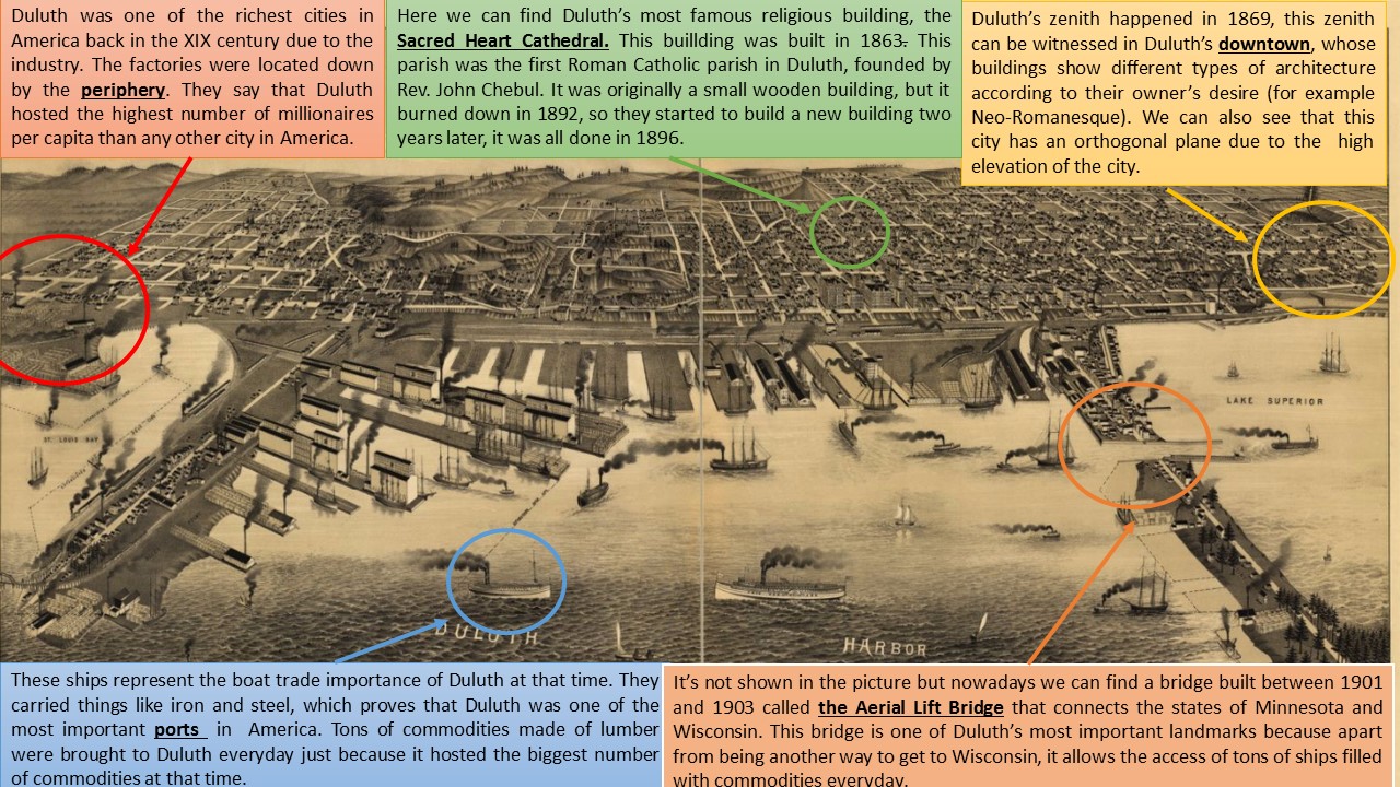
This map was drawn by Henry Wellge and published by Beck & Pauli in 1887. It represents the city of Duluth, Minnesota, at that time. Henry Wellge is one of the most famous artist of bird-eye-view paintings of the XIX century, he painted more than 150 cities views of twenty-six states and the Province of Quebec. Duluth is located in Saint Louis County, in Minnesota. It is the second-largest port on Lake Superior’s shores, being also the second-largest city in Minnesota. Furthermore, Lake Superior is the largest lake found in the Great Lakes. The Great Lakes are a set of interconnected freshwater lakes located in Northeastern America, on the Canada–United States border. These lakes are: Superior, Michigan, Huron (or Michigan–Huron), Erie and Ontario. Together they form the largest group of freshwater lakes on Earth, containing 21% of the world’s surface fresh water by volume.
In relation with the town planning, Duluth has an orthogonal plane, it means that its houses are arranged in a regular way and they are all connected by tracks or roads. In regards to the urban structure, Duluth’s downtown has some beautiful houses in which rich people live, whereas the periphery is full of factories, established in the XX century, that represent Duluth’s main economic activity: industry. Due to the natural characteristics of the Lake Superior area, the cold climate and the poor soils, Duluth has little agriculture.
To understand how Duluth was back in the XIX century, Dr. Foster (1869) wrote an article in the Duluth Minnesotian newspaper, in which he explained the reality of Duluth at that time: “Newcomers should comprehend that Duluth is at present a small place, and hotel and boarding room accommodation is extremely limited. However, lumber is cheap and shanties can be built. Everyone should bring blankets and come prepared to rough it”. After reading this, we can guess that Duluth was a rough place to live and their inhabitants developed in poor conditions. The situation got even worst when the stock market crashed in 1873 and Duluth nearly disappeared from the map. But in the late 1870s the city bloomed again because of an industrial boom concerned lumber and mines. In addition, the system of railroads and trains that connected Duluth with another important cities located in the Midwestern of America, like Chicago, was completed. As a consequences, by the end of the century Duluth had almost 100,000 inhabitants.
Regarding the monuments in Duluth, we have to remark the importance of the Aerial Lift Bridge. Basically, the Aerial Lift Bridge was built between 1901 and 1903 but it has been renovated few times from its beginning. It is located in Lake Avenue, from where it spans until Duluth Ship Canal, which connects the city of Duluth with Minnesota Point. Another important landmark is the Canal Park, which is a walk right next to Lake Superior’s shores whose path is filled with stores and another establishments. It has a beautiful scenery and you can do a lot of things like shopping, eating or riding a bike while you are enjoying the beautiful landscape that is next to the path. At last but not least, the Sacred Heart Cathedral is Duluth’s most famous religious building. It was built in 1863 by the Reverent John Chebul as the first Roman Catholic parish in Duluth. At the beginning, the building followed the Neo-Gothic style and it even had a three-spired brownstone, but it burned down in 1892 and it had to be reconstructed. It is located right in the center of the city and for years the building served as a refuge for some Duluthians that required help during tough times.
Ana García Cuadrillero