04/29/16

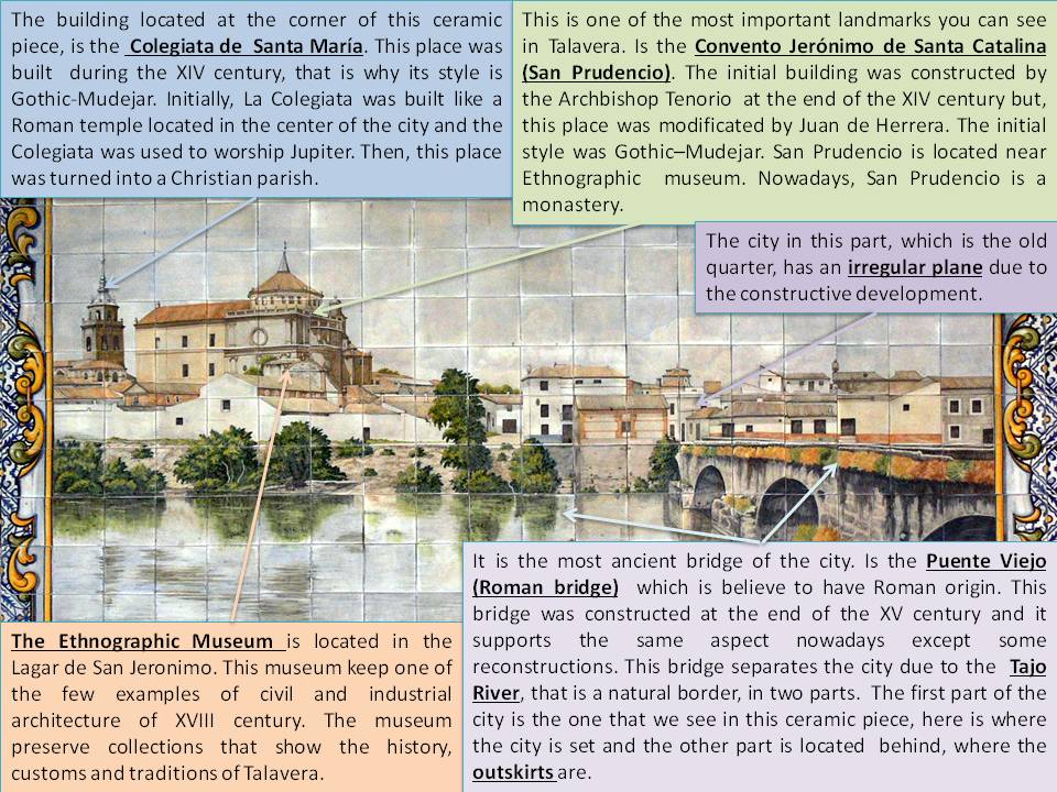
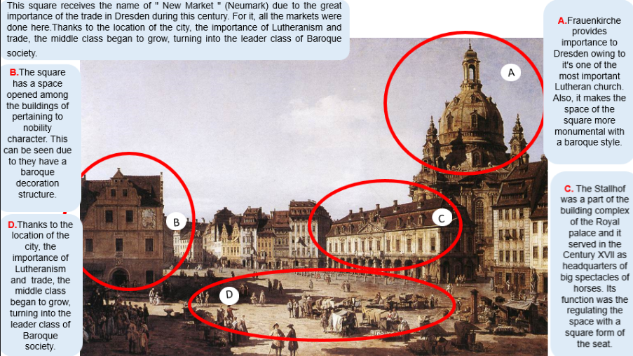
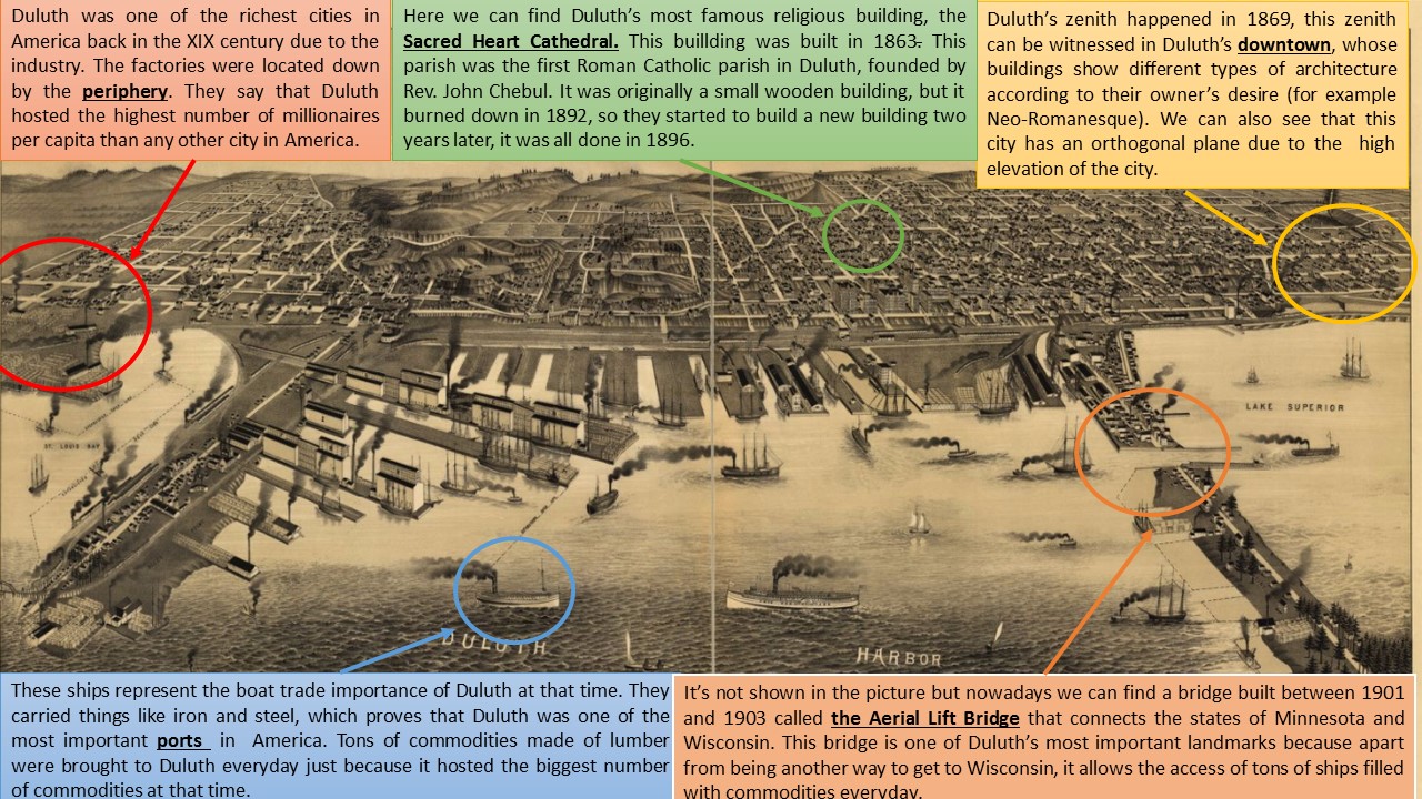
VIENNA (George Braun & Franz Hogenberg, 1617)

IMAGEN

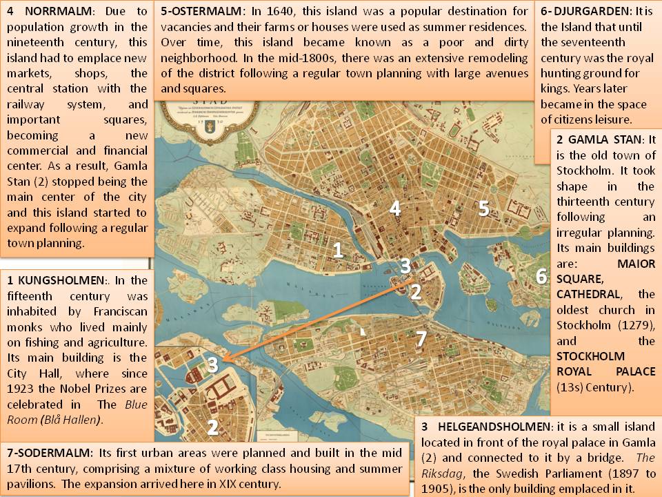
This image belongs to a collection of engravings of urban plans entitled Civitates Orbis Terrarum, published by Georg Braun, a German geographer and cartographer, and Franz Hogenberg, a German painter and engraver. This work was conducted between 1572 and 1617, just before the extensive devastation caused by the Thirty Year’s War. This great city atlas eventually contained 546 prospects, bird-eye views and map views of cities from all over the world. Among them we can admire this representation of the imperial capital of Austria, Vienna.

Vienna is placed on the riverside of the Danube river, in the oriental part of Austria. The river connects Central Europe to the Black Sea and has been used as a natural border many times throughout history. Concerning its specific geographical location, Vienna is in the Valley of the Vienna Woods, at the foot of the foothills of the Alps. The appearance of the city seems to be irregular, though we can see zones on the bottom left that looks like orthogonal. The property consist of medieval core, a former military Roman camp. Its remains stills visible in the urban medieval fabric of streets and alleys. In the 12th century, the urban development expanded beyond the Roman defences, which were demolished. The walls of the medieval city surrounded a much bigger area and were reconstructed after the Ottoman conflicts in the 16th and 17th century. The urban and architectural qualities of the Historical Centre of Vienna give exceptional testimony for a constant exchange of values along the second millennium.

Concerning the buildings inside the city, they show the big changes that the city of Vienna experienced from the Middle Ages to the Renaissance, as the Baroque period had not begun yet. This bird-view is considered to be one of the principal historical sources to know the appearance of the Gothic architecture of the city. Supposing that the monastic complexes and churches were generally constructed of stone, the residential neighbourhoods were of wood and suffered frequent fires. Out of the wall there are also houses, which is typical of the cities of the Modern Age because the medieval hulls were insufficient. The cities incorporated squares, gardens, sewerage, paving, etc. in their streets. The biggest and more significant streets were placed downtown, around important elements, as St Stephen’s Cathedral.

Thus, the interior of this city contains a number of medieval historic buildings, including the Schottenstift (the oldest monastery in Austria), the churches of Maria am Gestade (one of the most emblematic Gothic structures), Michaelerkirche, Minoritenkirche and Minoritenkloster. Saint Stephen Cathedral is dated between the fourteenth and fifteenth centuries, and clearly dominates the picture. It is crowned by a needle-shaped tower (Steffl), built in Gothic style, which is one of the most important religious symbols of Vienna.

Regarding the social activities, in the town centre there is a square where it is very possible that people devote to trade among other activities. Just outside the walls there are different groups of population: people at the top of the image seems to practice animal husbandry or trade. As we go down to the left, we can see men carrying goods. Then we stumbled upon the “Fort Boarium”, or the pork market of Vienna; and below we can see some passenger cars pulled along by horses. In the foreground we can see a large number of people carrying things and some of them look like being warriors. In the river we can see many boats, some fishermen and other merchants, because the salt trade was an essential activity at that time; although there are people who walk by crossing the bridges they had. The boats were made of wood to the edge that is on the right. At the top right, we see a line of people waiting to enter into the city, so we assume they were new immigrants in Vienna. The landscape in the surrounding area is formed by green plains, so we can deduce that agricultural activities are practiced. In the background of the image we can see a few mountains; on the other hand, in the foreground there is a river. The nearness of this one offers to the city supply of water and fish, and provides a trade route. We cannot forget that access to raw materials is essential in order that a city could develop correctly.

The imperial family Habsburg reigned in Austria and other Central European countries from 1278 to 1918. The struggles between Catholics and Protestants (Habsburg defended Catholicism) and the Turkish threat overshadowed the political life of Austria in the 16th and 17th centuries. The Peace of Westphalia (1648) and the Peace of Carlowitz (1699) ended, respectively, to both problems and consolidated the position of Austria as a European power. The Habsburgs made the city their capital from 1556 and its importance was enhanced with the expansion by the valley of the Danube. It became a core of European Baroque thanks to the construction of major architectural works and musical creations (from the 16th century, Vienna has been universally recognized as the musical capital of Europe).

Olga Arriero Gallego

04/26/16

SALT LAKE CITY (Thomas Kinkade, 2005)

Salt Lake City (Thomas Kinkade 2005)

This painting is entitled “Salt Lake: City of Lights” and the author is the very well-known American artist Thomas Kinkade (1958-2012). It was made in the beginning of the XXI Century and represents a view of Salt Lake City, in 2005. The painting captures the city of Salt Lake at sunset, and displays some significant urban elements such as  The Church of Jesus Christ of Latter-day Saints, The Joseph Smith Memorial Building, named after Joseph Smith, founder of the Mormon religion, and The Utah State Capitol, which is the headquarter of Utah State.

Salt Lake City is situated to the North of the Utah State and to the Northeast of The Salt Lake Valley, surrounded by the Great Salt Lake to the Northwest and the Wasatch and Oquirrh mountains in the Eastern and Western frontiers respectively. The Great Salt Lake is separated from the main city by large swamps and marshlands, and the metabolic activity of the bacteria within them gives birth to a phenomenon known as “lake stink”, a scent that is reminiscent of rotten eggs, twice a year during a few hours. The highest point in Salt Lake City is Twin Peaks, at the Southeast of the Wasatch mountain chain. This mountain chain, with the Oquirrh hills and the Great Salt Lake defines the topographic characteristics of the city.

The city plan is based on parallel and perpendicular streets that meet on the main points of the city, such as The Church of Jesus Christ of Latter-day Saints, The Joseph Smith Memorial Building and The Utah State Capitol among others. This street distribution results on a draughboard design. The main downtwon streets are extremelly wide, due to the original idea that took into account that a cart could easily move in any of the avenues. The Church of Jesus Christ of Latter-day Saints started its construction the 6th of April of 1854, but during the Utah War the foundation of the church was burried. It stayed this way until 1858, when the efforts of constructing the temple were resumed and it was discovered that the original foundation had crumbled. A new quartz foundation replaced the old one and the temple was successfully finished in the 1890s. Today it is one of the main touristic attractions of the city and also the centre of the Mormon religion in the State of Utah. The interior of the Church is strictly prohibited for those who aren’t mormons, but the square of the Temple is full of volunteers and missionaries that gently offer 30 minutes tours in 30 different languages.

To our left, we can see the Utah State Capitol, a building designed in 1916 by local architect Richard K. A. Kletting, who also designed the Enos Wall Mansion, now a landmark for the Last-day Saints Bussiness College campus. This Capitol underwent one of the largest historical preservation projects in the United States from 2004 to 2008. The Project had as its goals to protect the building against posible earthquakes and to repair and restore the original artwork. We can also appreciate on the right section of the painting the Joseph Smith Memorial Building, that was built betwenn 1909 and 1911. This building takes its name from Joseph Smith, founder of the Latter Day Saint movement (also known as Mormon religion). Its location is on the corner of the Main Street and South The Church of Jesus Christ of Latter-day Saints. At the centre of the canvas we can appreciate skyscrappers who are the result of more modern city designs as well as the creation of a Central Business District for the city.

A mayor for the city was chosen for the first time in 1911, Samuel C. Park, who focused in updating the precarious infrastructures of the city. In 1929, due to The Great Depression, lots of the citizens lost their jobs and homes and were forced to live in the streets. However, by the end of the World War II the city rose and recovered its economy. During the XXIst century a Financial District was created in order to strengthen the economy of the city. Salt Lake City held the Winter Olympic Games in 2002, and due to its dinamic and cosmopolitan society, it is no surprise that nowadays is a city where various artistic and cultures currents meet, making Salt Lake City one of the most liberal cities in the United States.

Íñigo Monje Vigón

04/25/16

STOCKHOLM (Påhlman & Hanzon, 1930)

FOTO BLOG

This map represents the shape of Stockholm city, in Sweden, during the XX century (1930). It has been found in a government website where a lot of old maps are displayed. The only information related to the publishers is that the image was emitted by the Mayor State Pahlman and Hanzon (Generalstaben genom Påhlman och Hanzon). The importance of the map is that it shows the distribution of the city in several islands and its expansion and evolution due to the population growth in nineteenth century. Since its origins in the thirteenth century to defend the Malar Lake area and promote the sea trade, Stockholm became one of the main cities in Sweden due to its strategic geographical position. However it did not grow much until the mid-nineteenth century with the Industrial Revolution, when many industries were located in the capital, causing high immigration from the field and creating the urban structure showed by this map.

According to the layout and the social and economic issues, it is clear that this city is composed by  several islands over the Malaren Lake connected by bridges. Interestingly, we can point out two different shapes of urban spaces attending to the age of the islands: the center of the map (Gamla Stand and Kungsholmen islands), which follows and irregular town planning, and the north and south of the map (Normalm, Ostermalm and Sodermalm), where the expansion of the new city was emplaced following a regular urban structure.  Gamla Stand is the old town of Stockholm and it has an irregular layout with narrow cobbled streets and medieval german style buildings. Due to population growth in the nineteenth century, as the picture shows, the expansion area (Normalm and Ostermal) started to emplace new markets, shops, the central station with the railway system, and important squares, becoming a new commercial and financial center. As a result, Gamla Stan stopped being the main center of the city, and Normalm and Ostermal started to expand following a regular town planning based on a reticular expansion with rectangular blocks and open squares. These expansion areas were connected to Djugarden district by a bridge in order to keep in contact to the leisure island in Stockholm. Innovations in transportation can also be seen in the map in the railway line, built in 1860. The railway follows the river in the north to promote the commercial trade, goes over the water through the central island, Helgeandsholmen, where the administrative center is located (Swedish parliament), and continues on the south where it is divided on the east along the coast (Sodermalm) and on the west through the city. This railway settlement emphasizes the foundational idea of Stockholm as a port city.

Regarding to the monuments displayed in the map, there are a lot of outstanding buildings that determined the layout of the city and the uses of each island. For example, the little island located in the center of the picture contains only one building, The Swedish Parliament. In addition, there is an island dedicated to citizen´s leisure where there are important elements, such as the first open air museum and amusement park in the world. Lastly, is needed to highlight that the most remarkable building in the map is the Royal Palace, located the old town (Gamla Stand). The first building emplaced in this place was a fortress with a central tower built created in the thirteenth century by Birger Jarl in order to defend Lake Mälaren. The fortress grew into a palace, called Tre Kronor («Three Crowns»). In the late sixteenth century many works were made to transform the old fortress into a Renaissance palace under the reign of King John III. At the time of this map, 1930, the royal family still had residence in this palace. From 1981, they set the Drottningholm Palace as a real residential in the outskirts of the city.

To sum up, according to the social activities, in the thirteen century, the main activity in Stockholm was the sea trade because of its location in Malaren Lake. After industrial revolution in XIX, this city became in an economical area based on industry (exportations of wood and other raw materials), and services such as tourism, finances or new technologies.

Ana Orche de Tomás

04/25/16

SALAMANCA (Anton Van Den Wyngaerde, 1570)

presentacion-powerpoint-pg2

This is a drawing that represents a view of Salamanca from El Arrabal, in 1570. It was made by Anton Van Den Wyngaerde in 1570 and has been collected for a project by Silvia García Alcázar and Fernando González Moreno at the University of Castilla and León. Wyngaerde was a Flemish artist who was commissioned by King Felipe II to visit Spain and draw a number of views of many Spanish cities between 1561 and 1570.

Salamanca is located in the Comunidad Autónoma de Castilla y Leon. Its origins are dated about 2,700 years ago during the Early Iron Age, when the first people who inhabited this land settled on the hill of San Vicente, on the banks of the Tormes river. Since that moment, the city has been inhabited by different people, such as Vacceos, Romans, Visigoths and Muslims. Raimundo of Borgoña, son of King Alfonso VI of Leon, was in charge of repopulating the city during the Middle Ages and laid the foundations for the current Salamanca.

As we can see in the engraving, there are three parts in the city: the old quarter, the outskirts and the Tormes river, which was used as a natural border as well as a way of defense. The town has a typical medieval structure, which means that does not have a fixed pattern as conform to the historical and geographical circumstances. The streets have an irregular layout, but are organized with the aim of forming a unitary space. In addition, this type of cities is organized in neighborhoods that each has often his own political organization. Usually, in the city center lived the rich people with high purchasing power, while the poorest occupied the outskirts, outside the walls. The construction of city walls aimed to protect and defend the town. They were built around the city to protect citizens from possible diseases, epidemics or potential wars and attack enemies. In the picture it is possible to appreciate some gates in the city wall (Gate of Zamora, Gate of Toro, Gate of Sancti Spiritus), as well as a number of cottage located outside the wall above left.

In this picture it is shown the Old Cathedral of Salamanca, founded by Bishop Jeronimo of Perigord, the first bishop of the Diocese of Salamanca. As a curiosity, the Cathedral originally had three naves, semicircular apses and a famous garland dome in the transept as it was common in Romanesque style. The cathedral also has two towers at the foot. Later, it was constructed a second Cathedral in Gothic style, joined to the previous one. That is a truly rarity in Art History.

Near the Cathedral we can see the University of Salamanca. It is one of the oldest universities in Spain, founded in 1218 by King Alfonso IX. In this university some teachers have taught distinguished classes throughout history, such as Fray Luis de León, Beatriz Galindo, Melchor Cano, Francisco de Vitoria and Miguel Unamuno. A surprising fact is that within the halls of this university many important figures that have passed into history, for example Miguel de Cervantes, Hernando Cortes and Christopher Columbus.

In the image we can also see the Roman bridge crossing the Tormes river and being part of the Via de la Plata, one of most important ancient Roman roads. This bridge is made of stone, much of it rebuilt by King Felipe IV in 1677. The Tormes river is a tributary of the Duero river; it starts in Avila province and flows into the Duero river. It is very important for the city of Salamanca because it works for water supply and many women washed their clothes down the river. Both the bridge and the river has been featured in famous works of literature such as Lazarillo de Tormes. In the XVI Century, Salamanca was a very important city thanks to its university and also its cattle fair and other commercial activities. It was the Golden Age for the city.

Paula Cecilia González

04/25/16

ALEXANDRIA (Henry de Beauvau, 1615)

FOTO BLOG

This engraving is part of the book Relation journaliere du voyage du Levant, a collection of 47 drawings and maps, written in 1615 by Henry de Beauvau, a soldier and traveller in the Middle East. The image is adapted from the original published by Georg Braun and Franz Hogenberg in the first volume of Civitates Orbis Terrarum, an atlas of cities of the world that was published in Cologne in 1572. It represents the city of Alexandria, which is the second largest urban area in Egypt after Cairo.

Alexandria is located in the north of the country, in a peninsula of the Nile delta. The site was chosen by Alexander the Great in 331 BC because it was considered a safe natural harbour for his fleet, in addition to the healthy climate, abundant fresh water and limestone quarries nearby to supply its future constructions. Alexander was also responsible for organising the urban planning, that followed an orthogonal distribution with parallel and perpendicular streets. However this urban layout was destroyed during the Middle Ages because its inner development turned into irregular. Nowadays, only two parallel streets in the interior still remain from the original structure.

The city was surrounded by a wall of 15 km. Outside this city wall, it is possible to appreciate the outskirts and the cropfields. Also, a channel was built to communicate Alexandria with other cities and another ports located in the mouths of the Nile Delta. We can also see some monuments such as the Pompeyo Column, the Garophalo Lighthouse, the seaports and several orchards. Alexandria was a city with many characteristics of Greek and Roman architecture and urbanism; it had numerous temples, palaces, theatres, baths, gardens, etc. The lighthouse of Alexandria is recognized as one of the seven wonders of the world. It has a height of 134 m and was for centuries the tallest man-made building in the world. After suffering two earthquakes in 1303 and 1323, it was destroyed. The city also housed the most important library in history. It was simultaneously a museum, a school and a centre for educational research. It held the largest number of existing Greek texts in the classical world. Unfortunately, this library suffered a fire in the fourth century. There is now a new Library Alexandrina on the same site, which opened in 2003.

The geographical location of Alexandria between the Nile river and the Mediterranean sea allowed it to become the most important city of the ancient world. Modern archaeological digs have found remains of goods from around the world, from Chinese ceramics to Moroccan dyes. Regarding the local industry, there was a high production of silk, embroidery, cotton and wool. Warehouses were built to store and distribute spices. Thus, the role of the harbour was fundamental for the Egyptian economic development. Besides, the cropfields located on the shores of Lake Mareotis produced wheat, grapes and olives. These products not only supplied the city but were also exported. An interesting example is the Alexandrian wine found in some amphorae in Marseilles.

Since ancient times there have been two ports in Alexandria. The western port was used by fishing boats. An interesting point about this port is that it holds 80% of all foreign maritime traffic in Egypt. In addition, it can accommodate up to 250 large ships in the terminal of the Suez-Cairo pipeline located in Alexandria. Also, there is an oil refinery, a mall and many stores, making it the best port in the eastern Mediterranean. In comparison, the eastern port is less important and is used as a marina.

Today Alexandria is a modern city with a quadrangular urban structure. It is an important cotton textile trade centre in addition to chemical, mechanical, shipbuilding and banking industries. Almost all of the ancient monuments and works of art that speak about the history of Alexandria are scattered around the world. Unfortunately, most were stolen. In present Alexandria city we can only find a few remains of what was once an imperial city. Archaeological work continues to rediscover the past of the city, much of which is under water.

María del Mar Díaz López

04/25/16

TALAVERA DE LA REINA (Eduardo Gil, 1990)

1GEOB-santos-rosa

This ceramic piece was created in 1990 by Eduardo Gil, an artist from Talavera who worked in Antonio Gonzalez Duran’s workshop. Talavera is very well-known for its ceramic artworks and these two people are some of the main craftsmen in the city. It represents the city of Talavera de la Reina (Toledo), located in the Northwest of Castilla-La Mancha. This ceramic piece depicts the city from the point of view of the outskirts, on the other side of the bridge over the Tajo River. Since that time, the city of Talavera has not undergone many urban changes.

Talavera is located in the West of Toledo province and its historical origin is Pre-Roman. The city is settled next to the Tajo River. A lot of different civilizations have been interested in Talavera since its creation. First, the Romans were amazed by its natural landscape and wanted to make this place their property; therefore, they called it Caesarobriga. Right after the Fall of the Roman Empire, the Visigoths conquered the city and left remains like the Villa del Saucedo. Finally, the Arabic kings thought that Talavera would be a good place to settle down, both due to the city location and the natural resources. Some historical testimonies and collections of samples can be admired at the ethnographic museum. It is located in Lagar de San Jerónimo, near the Convento Jerónimo.

Talavera has irregular urban layout due to the population increase in 1876. That is why there are some places that were constructed without a plan, but in later expansions to the east and the west, the buildings were constructed with a regular plan. The main economic source in this period of time was the manufacturing of ceramics, cotton mills and sewing circles. But nowadays, Talavera has some big factories and companies that export other products to the rest of the world. At the bottom of the picture, we can see the Tajo River, which, years ago, used to be a natural barrier of defense, and served as a supply for the people of the city. The river separates the city in two parts. In the upper part, we can see the entire city. However, in the lower part, which is not shown in this ceramic piece, we can see the outskirts without any constructions. The city expands from east to west, following the position of the river and another barrier, formed by a modern railway. In Talavera, we can find two bridges that connect the city and the outskirts. The bridge shown in the ceramic piece is the older one, known as the Puente Viejo. This bridge was constructed in the 15th century by Fray Pedro de los Molinos  and it is believed to have been originally of Pre-Romanesque style. However, it has been renovated on several occasions. Its last restoration was carried out in 2002.

The two most important monuments in Talavera, which are shown in this ceramic piece, are the Colegiata de Santa María and the Convento Jerónimo de Santa Catalina (San Prudencio). The beauty of La Colegiata resides in its two chapels: the chapel of “Santa Ana” and the Chapel of “Cristo del Mar”. What is important about both chapels is that the chapel of Santa Ana is known for being the only chapel in Talavera that followed the Toledano’s gothic style, and the Chapel of Cristo del Mar is known for having ceramic relics made by Ruiz de Luna. On the other hand, the Convento Jerónimo, which was founded by Archbishop Don Pedro Tenorio in 1372, is a point of reference in the old quarter. This convent received the name of Santa Catalina due to Archbishop Tenorio’s great devotion to her. Finally, the Archbishop donated this convent to the Jerónimos de la Sisla friars in 1398.

Ángel Santos Rosa

04/25/16

DRESDEN (Bernardo Bellotto, 1750)

Imagen Dresden

This image has been gathered from the website «Web Gallery of Art» and corresponds to Bellotto’s collection of artworks referred to Dresden city. Neumarkt is the square that it is represented in this picture. It is placed in downtown, old quarter, close to a meander that the river Elba does. The work, entitled «New Market Square in Dresden», was painted in 1750 by oil on canvas and its measurements are 136 x 236 cm. Now, this painting is preserved at the Gemäldegalerie, in Dresden. The author is Bernardo Bellotto (Venice, 1721 – Warsaw, 1780), who was an Italian painter and engraver specialised as a vedutista, it means, a painter of urban landscapes. Bellotto began his artistic formation when he was 15 years old, in the workshop of his uncle Giovanni Antonio Canal, Canaletto. There he perfected the painting of vedute. He travelled a lot and worked for the royalty in Dresden, Vienna and Munich, but he eventually lived in the court of Estanislao II Poniatowski, in Warsaw.

Dresden is the capital of the Saxony, Germany. Located in Europe center, it is an economic important place since it had a great relevancy in trade. Thanks to the Elba river, the city could have raw materials for its economic development, many of them extracted directly from the river and others by using its water for cropfields and water supply. Owing to these factors, the city could develop trade across the river and more beyond to the sea. As a result of this, the middle class experienced a rapid growth aimed to be the dominant class in Modern Times. After that, many reformations were done with the addition of new buildings highlighting the power of the bourgeoise and the socio-economic development of the city.

The city had an irregular layout from medieval times but in the Baroque era it experienced an important urban development. As a consequence, the ancient buildings were knocked down to be able to construct new squares and open spaces with a more regular plan, as it appears in the picture. Thus, Neumarkt looked like being more spacious, squared and spectacular thanks to the openings among buildings, the wide area in the centre and the baroque façades of the new palaces. This renovation also contributed to enlarge the urban space. It is true that Dresden is so-called the «Florence of Elba» due to the monumental importance of its Baroque type of buildings, constructed from the century XVII onwards.

In this picture it is possible to observe how the fundamental activity in the Baroque era was trade. Also the importance of Lutheran religion and its historical importance for the whole Germany. As an example, the most significant construction displayed in the background, on the right, is the Frauenkirche. This is a Protestant church, with a central ground plan constructed between 1726 and 1743. During the Second World War it was almost totally destroyed because of Dresden Bombing, in 1945. The German Democratic Republic supported its ruins as a monument that remembered the destruction of the war. After the Fall of Berlin Wall, its reconstruction was begun in 1994 and finished in 2005. Nowadays, it is a symbol of peace. Its dome of round stone dominates the whole city and contributes to give an inspirational perspective to the narrow streets and the irregular plan of the city. Also, in Neumark, there is a statue that conmemorate the importance of Martin Luther and how Dresden is one of the most emblematic places for the Protestantism.

Another important building is the Stallhof, that was part of the Royal Palace complex and served, in the 17th Century, as headquarters and scenary of horse spectacles. It was finished in 1591 by Cristiano I. Today it is still used for cultural events as well as the Christmas Market, the Striezelmarkt, which is one of the most ancient and large markets of Germany. Occasionally, spectacles of horses and theatre events take also place here.

Lucía Arias García

04/25/16

DULUTH (Henry Wellge, 1887)

 1GEOB-Garcia-Cuadrillero

This map was drawn by Henry Wellge and published by Beck & Pauli in 1887. It represents the city of Duluth, Minnesota, at that time. Henry Wellge is one of the most famous artist of bird-eye-view paintings of the XIX century, he painted more than 150 cities views of twenty-six states and the Province of Quebec. Duluth is located in Saint Louis County, in Minnesota. It is the second-largest port on Lake Superior’s shores, being also the second-largest city in Minnesota. Furthermore, Lake Superior is the largest lake found in the Great Lakes. The Great Lakes are a set of interconnected freshwater lakes located in Northeastern America, on the Canada–United States border. These lakes are: Superior, Michigan, Huron (or Michigan–Huron), Erie and Ontario. Together they form the largest group of freshwater lakes on Earth, containing 21% of the world’s surface fresh water by volume.

In relation with the town planning, Duluth has an orthogonal plane, it means that its houses are arranged in a regular way and they are all connected by tracks or roads. In regards to the urban structure, Duluth’s downtown has some beautiful houses in which rich people live, whereas the periphery is full of factories, established in the XX century, that represent Duluth’s main economic activity: industry. Due to the natural characteristics of the Lake Superior area, the cold climate and the poor soils, Duluth has little agriculture.

To understand how Duluth was back in the XIX century, Dr. Foster (1869) wrote an article in the Duluth Minnesotian newspaper, in which he explained the reality of Duluth at that time: “Newcomers should comprehend that Duluth is at present a small place, and hotel and boarding room accommodation is extremely limited. However, lumber is cheap and shanties can be built. Everyone should bring blankets and come prepared to rough it”. After reading this, we can guess that Duluth was a rough place to live and their inhabitants developed in poor conditions. The situation got even worst when the stock market crashed in 1873 and Duluth nearly disappeared from the map. But in the late 1870s the city bloomed again because of an industrial boom concerned lumber and mines. In addition, the system of railroads and trains that connected Duluth with another important cities located in the Midwestern of America, like Chicago, was completed. As a consequences, by the end of the century Duluth had almost 100,000 inhabitants.

Regarding the monuments in Duluth, we have to remark the importance of the Aerial Lift Bridge. Basically, the Aerial Lift Bridge was built between 1901 and 1903 but it has been renovated few times from its beginning. It is located in Lake Avenue, from where it spans until Duluth Ship Canal, which connects the city of Duluth with Minnesota Point. Another important landmark is the Canal Park, which is a walk right next to Lake Superior’s shores whose path is filled with stores and another establishments. It has a beautiful scenery and you can do a lot of things like shopping, eating or riding a bike while you are enjoying the beautiful landscape that is next to the path. At last but not least, the Sacred Heart Cathedral is Duluth’s most famous religious building. It was built in 1863 by the Reverent John Chebul as the first Roman Catholic parish in Duluth. At the beginning, the building followed the Neo-Gothic style and it even had a three-spired brownstone, but it burned down in 1892 and it had to be reconstructed. It is located right in the center of the city and for years the building served as a refuge for some Duluthians that required help during tough times.

Ana García Cuadrillero

04/25/16

ALEXANDRIA (Braun & Hogenberg, 1572)

1GEOB-palomo

This representation of Alexandria belongs to the first Latin edition, volume II, of the book Civitates Orbis Terrarum which was published in 1575. Its principal authors were the editor Georg Braun and the important engraver and publisher Franz Hogenberg. This book is very important because it was the second oldest printed atlas in the history of world cartography, and the first atlas of towns. The image that I am going to describe shows a bird eye’s view of Alexandria, a very important city in the north of Egypt. It also displays the urban structure and the economic activities of the city in the 16th century.

Alexandria was founded in 331 BC by Alexander the Great in the Nile Delta, and the close proximity of Rhakotis meant access to labor and other services for the creation of this city. The great location was taken advantage of the crops, due to the fertile soil, the trade with other countries because of the harbor, etc.

In the image, we can appreciate the urban layout of the city. This city was surrounded by a city wall, which had an irregular shape, and it protected the city of external attacks; until the 19th century the gates were close because of Bedouin raids. It had four gates, the most important one was the Nile gate due to the trade, however, in the 16th century, it was obstructed by sediments, and the products that arrived through this gate were transported by camels. The town planning was irregular, and the branches of the Nile also set where the buildings were situated; moreover, we can observe that the streets were very narrow. Though in the image we can observe that was a very irregular plan, the ancient town, according to Alexandre’s foundation, had a grid plan with two main streets. But the story of Alexandrian Urbanism has been modified by the political empires, Egyptians, Romans, the Islamic period…, so this is why in the 16th century the city was so different.

Regarding the buildings, the majority were religious spaces. We can observe in the representation mosques, Egyptian monuments, Roman buildings… This variety of buildings is because of the different cultures that have lived there. Concerning the Arabic buildings, the Abu el-Abbas mosque, where the tomb of Abu el- Abbas was located, constructed in the 14th century, was the most important one; it was rebuilt in 1477 under the order of the Mamluk governor Gaqmas el-Zahry. We can distinguish also some Roman buildings, such us the Cathedral of Alexander the Great, Saint Catherine which was constructed during the Roman period, in 527, and the Pompey’s Column. But in spite of all these monuments, the most important was the lighthouse of Alexandria, built up during the Ptolemaic Dynasty era. Located on the eastern end of the island where the Qaytbay Fort stands today, it was considered one of the seven wonders of the ancient world. But it was destroyed in a 13th century by an earthquake.

The image also shows us the economic activities. Due to the great location of the city, its principal economic activity was the harbour trade. Although the Ancient harbour was not used in the 16th century because traders started to use another seaport, this one was kept busy; it received products from the inland areas of the Nile river, Greece, and other European countries. Nevertheless, not only the harbour was the principal activity; after the Ottomans arrival the bazar became into one of the main economic sources. It was divided into different souks in which people could buy a lot of products like special clothes for the desert. Finally, it is curious to note that nowadays the harbour is the most important one of the country, so it keeps some of the importance that it had years ago.

Ainoa Palomo Martinez

04/25/16

CASARES (José Luis Suárez, 2009)

1GEOB-Rodríguez-Colás

This picture was painted by José Luis Suárez in 2009; we can see his signature in the bottom right border pointing out “JL Suárez”. We can find this picture in the personal website gallery of the author. Helena Sassone, art critic, said that José Luis Suárez has an exceed of color and technique in his pictures and it is also remarkable his aesthetic balance. We can observe that he uses dark and light colors to achieve the evening effect that the picture has. She also said that painting landscapes is something that he dominates, as we can see in this picture. The image represents Casares, an Andalusian village in Málaga province. It is located in the end of the Ronda Mountain Range at the top of a hill, which is typical in Muslims settlements as well as a place easy to be defended.

The history of Casares could start 100.000 years ago with Neanderthals, because the place where Casares is located offered good conditions to life for groups of hunters-gatherers. Since 50.000 BC the Homo Sapiens Sapiens occupy this place. It is known that Gran Duque Cave used it as an accommodation place because of the remains that were found such as vessels and personal accessories (bracelets and necklaces). At the end of Prehistory existed in this place some strengthen hamlets. In the III Century BC all the groups that live in this place (Iberian population) joined together and founded a settlement named Lacipo. But Casares was founded as a city in 61 BC when Julius Caesar ordered as acknowledgment for being cured in Hedionda Baths. However, the old quarter is Arabian due to the following invasions.

This is a typical Andalusian village with white wash houses and narrow, steep streets. We can appreciate that the village is built around the Incarnation Church and the castle with an irregular plan, due to the Medieval Muslim influence. Around the village there are crop fields that are economically used for farming. Herbaceous crops, such as alfalfa and oats, and woody crops, like orange and fig trees, are the most characteristic ones.

Concerning the urban layout, Villa Street is one of the main streets of Casares and it joins together the castle and the Spain square. It is a narrow and steep street where is situated the city council and the Ethno History museum. In the center of the village it is the Incarnation Church, Casares Castle, Vera Cruz Chapel and the cemetery. Incarnation Church was built at the end of XVI century and very likely on top of the biggest ancient mosque, located in the Fountain Plain. It has only one nave and it is built with a cross floor. The Arabian influence can be seen in the bell tower, which is influenced by Mudejar art and also, in the castle, which was built in the XIII century by the Muslims with a defensive purpose. Only have been remained some parts of the wall and some walls and towers of the fortress. The wall is an irregular polygon with enterings and projections because of the topography. The cemetery stands out due to its circular shape arranged according to the topography and the position of the niches, it was created in the Visigoth age, it offers splendid views and it is located in the castle enclosure as well as Vera Cruz Chapel, which was built in the XVI century, but now only one of its naves remains.

We should mention that Casares was declared Historical-Artistic complex in 1978 and it is the village where Blas Infante, politician, writer, and the Father of «Andalusianism», was born. Are also remarkable Hedionda Baths, known because of this curative property, its origin is Roman, but they suffer several modifications since its construction. To conclude, I want to highlight that this village is so relevant in history, because of its strategic location. Many civilizations passed through it, leaving each one several contributions to increase the historical and artistic value of this village.

María Rodríguez Colás