
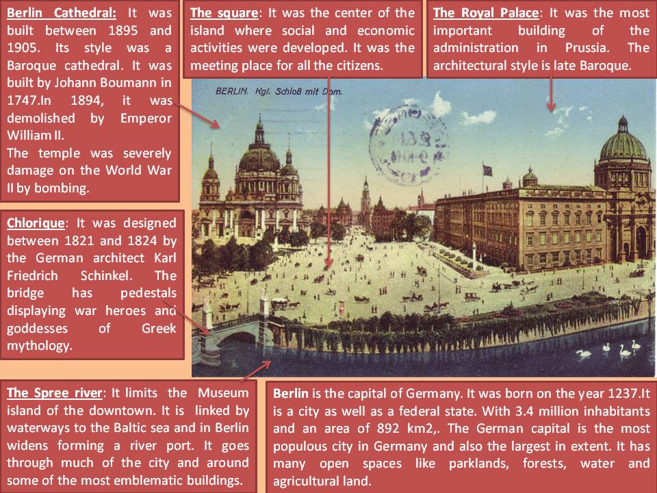
This picture is a coloured postcard that represents the center of Berlin. The author is unknown but this postcard belongs to the 19th century. Berlin is the capital city of Germany and one of sixteen German states. It is located in northeastern Germany, just 70 km from the border with Poland. We can appreciate its daily life around the most popular monuments in the city.
On the left the Berlin Cathedral (‘‘Berliner Dom’’), is a protestant temple located in the district Berlin-Mitte on the Spree island. On the right it is showed the ‘‘Stadtschloss’’ that was the Prussian Royal Palace. People used horse-drawn carriages as a typical way of transport at those days. We can also see in the picture the Palace Bridge (‘‘Chlorique’’) that was designed between 1821 and 1824 by the German architect Karl Friedrich Schinkel. The bridge has eight pedestals displaying war heroes and goddesses of Greek mythology.
Concerning the structure, the city of Berlin was born from the union of two towns founded on the year 1237, Berlin and Cöll. These towns joined in 1307 to form what today we know as Berlin. In 1415, the city was chosen the capital of the Principality of Brandenburg, which was part of the Holy Roman Empire. Berlin turned into the capital of the German Empire, into 1871, when Prussia achieved the unification of Germany. Since then it experienced a considerable demographic increase, from 824.484 inhabitants in 1871 to 1.888.313 in 1900 and to 4.024.165 in 1925. The city became into a cultural, architectural and financial center worldwide.
The morphology of Berlin was originally star-shaped, but nowadays, the urban layout is radio-centric. During the 19th century there has been many town planning. In the early 19th century, Karl Friedrich Schinkel embarks on a new model of city planning. It had aimed at unifying of Berlin. He designed a series of «architectural objects» that shaped an attractive cultural forum in the center of the city. Schinkel makes a Cölln Island in the Royal Palace, which links to the Altes Museum. In the middle of 19th century, there was another plan called ‘‘Hobrecht’’. It posed an urban design plan embracing the historic center by a succession of streets and squares. It formed concentric rings. The objective of the plan was to regulate and contain the urban landscape.
The downtown is placed in an island limited by the Spree river and is surrounded by a line of circular railroad (in the shape of a “head’s dog «). There are wide avenues that allow people to go from the center of the city to the suburbs.
Regarding the buildings we can remark two of them. Firstly, we can see on the right the Royal Palace. It was the most important building of the administration in Prussia. The architectural style is late Baroque. This building that was damaged in the Battle of Berlin in 1945 during the Second World War. On the left of the picture we can observe Berlin Cathedral. It was built between 1895 and 1905, although it was formerly a baroque cathedral built by Johann Boumann completed in 1747. That cathedral was demolished in 1894 by Emperor William II and was replaced by the present one, designed by Julius Raschdorff. During World War II, the temple was severely damaged by bombing. The reconstruction began in 1975 and finally ended in 1993.
In the 19th century, Berlin based its economy on industry but in the next decade declined due to rising unemployment. Now, Berlin is a city as well as a federal state. With 3.4 million inhabitants and an area of 892 km2, the German capital is the most populous city in Germany and also the largest in extent. It has many open spaces (parklands, forests, water and agricultural land) that comprise more than 40 % of the area of the city. Berlin is metropolitan area which is recognized to be a cultural and artistic center of excellence.
Irene Martínez García