
DUBLIN (Henry William Brewer,1890)
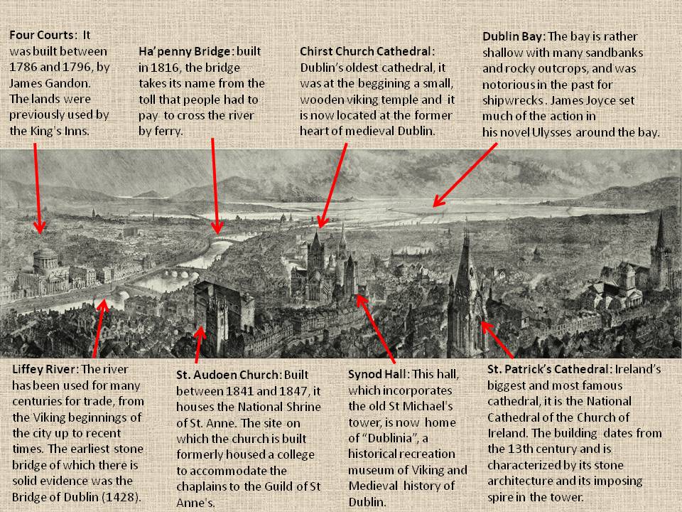
This panoramic view of Dublin, made by the artist Henry William Brewer in 1890 after visiting the city, was part of a supplement to the London Graphic newspaper. Brewer seemed taken back at the natural beauty of Dublin’s situation, quality of light, planning and architecture. The choice of vantage point seems almost like a retreat to the old medieval stronghold of the city, the Liberties. This area on high ground around Thomas Street was once one of the principle spines in and out of Dublin. His view is very different to that of his precursors, and suggests a different representation, with a largely non-neoclassical emphasis.
The picture was accompannied with a commentary, in which the author says that he likes the ‘picturesque’ quality of the Liberties. This is curious because that point would have been home to some of the poorest people in Dublin, many living in appalling conditions. However, Brewer chose to place the emphasis on Dublin’s churches and typical buildings. The perspectival manner he employs makes them seem like they are almost looming out of the city’s otherwise low-rise and gloomy fabric.
Dublin is situated at the mouth of the River Liffey, which goes into Dublin Bay, and encompasses a land area of approximately 115 square kilometers in east-central Ireland. It is bordered to the south by the Dublin Mountains, a low mountain range and sub range of the Wicklow Mountains, whereas
to the north and west it is surrounded by flat farmland.
The river divides the city into two sections, the Northside and the Southside. Two secondary rivers divide even more the city: the River Tolka, running southeast into Dublin Bay, and the River Dodder, running northeast to the mouth of the Liffey. A number of lesser rivers and streams also flow to the sea. Two canals (the Grand Canal on the southside and the Royal Canal on the northside) ring the inner city on their way from the west and the River Shannon.
The town planning and the structure of Dublin are very influenced by the geographical factors. Even though the streets of Dublin follow an irregular structure, the town centre is located near the Liffey River and the borders of the areas depend on this river and the smaller ones. That way, the expansion of the city has always gone from the sea and the river to the opposite directions (west of the coast, north and south of both sides of Liffey River).
The structure of the city has changed a lot since its foundation to the era of the image above, but it has changed even more from that time to nowadays. Some of those changes came from that riots and events that took place during Dublin’s history, but recent years have taken a complete turn to the landscape of Dublin: large companies have settled in the capital and new buildings have changed the picture. Dublin has become one of the most visited capital cities in Europe with some remarkable places like the Temple Bar or Guinness Storehouse, apart from the places shown in the picture.
The first historic reference to Dublin can be found on the writings of Ptolemy, who talks about a city or settlement in that area called Eblana, around the year 140. The Celts arrived in the bay around the year 700 BC, and converted to Christianity in the 5th century AD, thanks to the predication of St. Patrick, patron of Ireland. Around year 841, the Vikings came to the area and founded a commercial village on the south bank of the river Liffey which they called Dubh Linn (black lagoon).
In 1014, the Irish king Brian Boru defeated the Vikings and from the 12th century the city was definitely controlled by the Normans. In 1541 the Lordship of Ireland was abolished and the Kingdom of Ireland was born. Thus, in 1592 Queen Elisabeth founded the first University of Ireland, the Trinity College.
In 1801, England crushed several riots and abolished the Irish Parliament; after that, the seat of the Parliament moved to London and Ireland was integrated in the United Kingdom. By 1900 Dublin had ceased to be the most important city in Ireland surpassed by Belfast, a city that had experienced an important industrial revolution. In 1916 the streets of Dublin experienced a new uprising against British government. In 1919 the Anglo-Irish civil war began, destroying much of Dublin, from which came the recognition of the Free State of Ireland. The new political status lasted until the proclamation of the Republic of Ireland in 1937, and a new constitution replaced the Irish Free State by a new State called Éire. Dublin was considered the capital of the new republic from that moment onwards.
Miguel Fernández Sánchez
