
PALMANOVA (Vincenzo Scamozzi, 1593)
We can find this image in the «Civitates Orbis Terrarum», a city atlas elaborated by Georg Braun and Franz Hogenberg. It was published in 1572 and is compound by six volumes where we can find views and plans of the most important cities in that era.
Palmanova is to 120 km from Venice in the Friuli region, in the north of Italy, almost in the border with Slovenia and Austria. It has a surface of 1332 hectares and a population of 5.453 inhabitants. It is located on a plain, about 25 km from the sea. Its average of altitude is 30 m and it is located in a humid subtropical climate zone The function of the strengthened city of Palmanova was being a put of advanced garrison of the defensive belt of Venice. This city was built in a date that sent a clear message from the Republic of Venice about the function and importance of a new strength, which would act as limit before the Turkish invasions, not only towards the own Republic, but also towards the whole Christianity.
The author of this city is Vincenzo Scamozzi (1548-1616), who lived and developed great part of his work in Vicenza and Venice. He became one of the most important architects of the epoch and a model for years. He studied the Vitruvio’s classical texts and this influenced his work of which stand out the palaces and the villas. His masterpiece is the Villa Pisani, in Lonigo, Vicenza. This work combined the Villa Capra of the great Palladio with an influence of the Pantheon of Rome.
In 1615, a year previous to his death, Scamozzi published in Venice an extensive work in ten volumes, L‘idea Delli Architettura Universale, in which his architectural experiences are collected. Nine chapters of the second book are dedicated to treat specifically the topic of the military fortifications being based on a study of a set of the most relevant examples of the occidental Europe. In his treatise, Scamozzi includes a detailed plane of a theoretical strengthened city that has features in common with Palmanova.
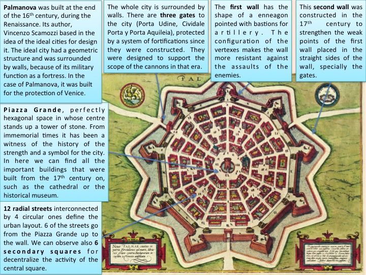
Palmanova was constructed in 1593 during the Renaissance, period in which the bourgeoisie arises as a new social class of power and for it, the city is understood as the economic and social centre. In this epoch a revolution took place in Italy in the field of the urbanism. This new current of thought has as aim improve the city by imposing the order and the greatness in its, recovering the classic ideas of the ancient Rome. For it, the town planning is recovered, across the designs and Marco Vitruvio Polión’s ideas, which gives place to the ideal cities, considered as utopias. Some of the architects who designed cities as these are Filarete, Leonardo de Vinci and the creator of Palmanova’s city, also considered ideal city, Vicenzo Scamozzi
About the analysis of the city, we can point out the following ideas. Its perimeter is identified as a polygon of nine sides and its central square, called Piazza Grande, is a regular hexagon. These configurations give place to a harmonious model thanks to the radial disposition of the streets. Six of them depart from the centre, of which 3 drive to the vertexes of the wall and the three remaining ones to the average point of three of the sides, constituting the access routes. As a result of this twelve radial streets divide from the ring more internal of the city, which is composed by concentric streets. Six secondary squares are opened in the centre of the apples with the intention so that all the activity of the city isn’t focused on the central square.
We can find the most important buildings of the city around the Piazza Grande. The fortification delimits an area of approximately 50 hectares with a capacity of fifteen thousand inhabitants. Nevertheless, in spite of a lot of efforts, it never reached to above the mentioned quantity of population, something that surprised the own Napoleon, who tried to give to the city a new brilliance.
The most remarkable thing is based on the degree of geometric sophistication that the design of the city offers us: radial streets born, on the one hand, of nine vertexes of the hexagon and, on the other hand, of the half of the segments that join them, they all don’t end in the hexagon of the central square, which form is accentuated by a great source of similar geometry. This great square allows the step of the traffic in the axis of each one of the sides, and the excellence of the tracing do that we are sorry about the absence of a success that would allowed the construction of buildings adapted to the geometry, whose equilibrium is indisputable. This would come to demonstrate that a tracing cannot do a city, though it is brilliant and it is magnificently proportionate.
As to the protection of this magnificent fortress, the three gates to the city (Porta Udine, Cividale Porta and Porta Aquileia) were protected by a system of fortifications formed by bastions, barbicans and trenches. The first ring of fortifications, the closest to the building complex, presents its walls in the shape of the top of an arrow. In the most distant point of each one of them, there is a bastion that joins others by means of curtains. Of all this turns out to be an enneagon that, thanks to the configuration of its vertexes, defends itself. All this is protected by a broad trenches, with three gates to the city in the centre of three of the curtains.
The second ring, which dates back to the 17th century, was constructed to strengthen the weakest points of the first ring: placed in the straight side of the existing walls, the first ones in being constructed were those who would be placed in front of three gates, the weakest part of the fortress.
The last and definitive ring was constructed in epoch of Napoleon, that is the reason why it doesn’t appear in the image, which dates back of the end of the 16th century. This way, in 1806 nine lenses were constructed, that is to say, the bastions were surrounded by a dry trench. Its construction towards to the outside, towards to the field, allowed the conservation of the present city.
Elena García Blanco