04/27/18

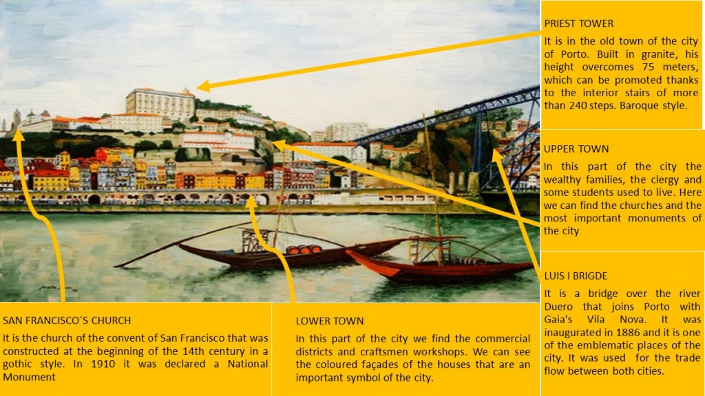
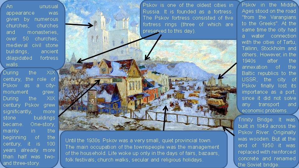
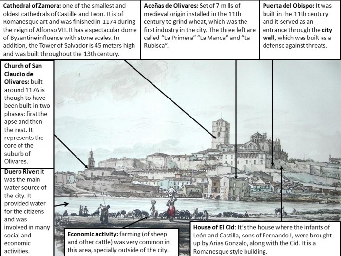
MALTA (Ignazio Danti, 1565)

malta-siege-16-century
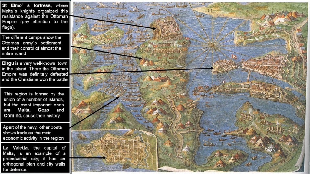
This work of art represents the famous battle between the Ottoman Empire and the Christians in the so-called Siege of Malta, occured  in 1565. We can find this painting in Rome, more precisely in the Vatican Museum. It was made by Ignazio Danti, a mathematic, priest and astronomer, between 1581 and 1582. The author is also recognized by his theory on perspective.
The Republic of Malta is an archipelago formed by three islands (Malta, Gozo and Comino) located in the middle of the Mediterranean Sea. These islands border to the north with Sicily and to the south with Libya. Currently, Malta is an independent country, member of the European Union, with an extension of 316 squared km and 413,609 inhabitants.
The island has not got huge forest, mountains or other geographical features, but small hills and cropfields built in terraces. The relief is made of calcareous rocks, formed by clay and sand, that are used for construction and provides a very typical urban landscape. Water resources are also very important thanks the strategical location of the island next to the Mediterranean Sea.
In the upper part of the central island we can see the star-shaped fortress of St Elmo, that was the largest defensive site in Malta. It is located in the currently region of Floriana, which is in La Valletta periphery. The Ottomans attacked this fortress when they lost one of their officers, and they finally conquered it on the 23rd of June, 1565. However, that conquest had a huge cost for the Ottoman army, as it took 30 days and 6000 soldiers died. When the Knights of Malta reconquered it, they increased the defences to avoid further attacks.
On the right side we can see Birgu (or Vittoriosa), that was the capital of Malta until the end of the Siege. There we can find the fort of St Angelo, one of the most important monuments on the island. Before the entrance there is a small wall with a defensive function. In this city with an irregular morphology, the Orden of St John prepared a surprising attack that Ottoman army couldn’t anticipate, so it was the beginning of end for Ottomans.
In the bottom left corner is depicted La Valetta, the currently capital of Malta. We can point out that this city was built after the siege and the defeat of the Ottomans, in honour to the Great Master of La Vallete. It was placed on the top of Sceberras mount to prevent another invasion. As we said before, it was built in the 16th century so it has got some Renaissance characteristics such as the organization in checkerboard to get an orthogonal morphology. A defensive function was added with the construction of a city wall and an strategic location near the sea.  The city has got different monuments that belong to the Renaissance era like the Great Master Palace.
The different camps depicted in the composition show the organization of the Ottoman army, that had the control of almost the entire region. The presence of so many boats indicates on the on hand the importance of trade and fishing as the main economic activities as well as the use of sea routes for transportation and networks. It is noticeable that corsairs were very frequent near the island and that was a huge problem for the economy of Malta. On the other hand, the boats in the picture are connected to the battle as most of the them belonged to the invaders army.
Carlos Carreras

04/23/18

CORDOBA (Anton van den Wyngaerde, 1567)

Diapositiva1

This image was made in 1567 and portrays a panoramic view of Cordoba and the Guadalquivir river from the point of view of the Calahorra Tower. The painter is Anton van den Wyngaerde, who was born in Belgium, and used different techniques and materials like pen, brown ink, watercolour and thick framing lines in black ink. Now it belongs to the Victoria and Albert Museum of London, but it was formerly included in an album of 31 other views of Spanish cities. 

There is a great amount of details in the representation of the houses and social activities of that time. Thanks to the river Guadalquivir, Cordoba had a good communication system with other places and its comercial power was very important during the Golden Age. The 16th century in Cordoba was characterized by being a period of economic expansion with respect to the Middle Ages after the conquest of Cordoba by Fernando III El Santo. But there is a decline at the end of the century in regards to the population, mainly due to epidemics, poor harvests and famine.

In the background it is possible to admire the mountains of Sierra Morena, so the view is incredible and represents an interesting balance between city and nature. In the foreground we can see people doing common activities. There are some peasants shepherding cows and donkeys near the bridge because the most common occupation in that period was farming.

The urban layout is irregular and the housing is enclosed by a city wall, which is typical in medieval towns. There are some buildings out of the city wall, to the other shore of the river, that can be considered the starting point for a suburban area or «arrabal». So the urban structure is divided in two sides by the Guadalquivir; on the one hand we have the city centre and the main monuments, and on the other hand there are cropfields, farms and lodges. Near of the Calahorra Tower is placed the Roman bridge over the Gudalquivir, and after crossing it, we will find the cathedral-mosque of Cordoba, which is the most important monument of the city and one of the most important in Spain. 

Mario Parrilla

04/23/18

PORTO (Marta Moro, 2009)

Porto is the most important city of Portugal, after Lisbon. It had 237.559 inhabitants in the year 2011, but is still growing. Porto is situated to the east of Portugal, in the estuary of the river Duero. This work of art belongs to the artist Marta Moro and shows a perspective of the city of Porto, focusing on the zone near to the Duero shores, where daily activity takes place. Also, it shows on the right the bridge of Luis I, one of the most emblematic monuments of the city.

As we can see in the picture, this city is divided in two parts: lower town and upper town. The lower town is the poorest part of Porto and there used to live workers and merchants because it is next to the river, where the trade flows. The upper town is the historical and richer zone, where the nobility and clergy lived. Here we can find the most emblematic sites of Porto, such as the Priest Tower and San Francisco´s Church. The image also shows two little boats in the foreground; they were used to move goods and people from one shore to the other shore of the river Duero.

One of the most important elements of the image is the bridge Luis I. In the past it was used as a connection between Porto and Gaia and also as a way for moving goods and people. It possesses two floors. The superior has approximately 390 meters of length and the lower one approximately 174 meters. The superior floor holds the line D of Oporto metro, whereas the lower route is dedicated to other vehicles like cars, buses or trucks. 

As secondary aspects, the image portrays with a great amount of details and chromatic variety how the city was in the past. We can see the colouring façades near to the shore of the river. It used to be habitual to paint the houses with different colours and in Porto this tradition continues nowadays. Since it is an ancient city, without no urban plan in its centre, there are no big open spaces and the streets are narrow. At present there is a line of streetcar that crosses the city centre. In both sides of the image it is possible to appreciate that constructions go on more beyond: this is an indicative that the city continues growing in both directions along the river.

Porto is known as the city of the bridges, there are around ten bridges, of different ages, and most of them cross the river connecting Porto with Gaia. Porto is a city walled and the history tells that it resisted three attempts of conquest on the part of the troops of Napoleon.

Rubén Villaseca

04/23/18

HAARLEM (Gerrit Berckheyde, 1696)

City in art

The painting we are observing is a view of the architecture and urban life of Haarlem’s main square in 1696. This image was painted by Gerrit Berckheyde (1638-1698), known mostly for his cityscapes. We can see how the painter uses a baroque style; we come to this conclusion due to the use of bright colours, the popularity of depicting scenes of everyday life and by the date in which this work of art was painted.

This scene was painted during the Dutch Golden Age (17th century) after the Dutch republic was formed when seven northern Netherlands provinces won their independence from Spain. The republic then developed a worldwide colonial empire that turned into the European centre of finance and culture. They took several western innovations and industrial techniques to places as far as Japan and India.

The City of Haarlem is situated by the river Spaarne and near the North Sea, on a very narrow piece of land surrounded by many different bodies of water and near the coastal dunes. That situation attempts to compensate the fact that some parts of the country are beneath the sea level. It was always considered a rather industrial city where you could find textile mills, shipyards and machinery plants, although it is also very famous for being the “flower city” as it was the main location of tulip bulb exports as it was the flower-growing district of the country.

As we can see in the image the urban planning of the city is quite common to other cities around Europe in that époque. Its city centre was determined by the location of a cathedral (Saint Bavo Kerk) and, or the city hall (Haarlem City hall). These two establishments make the town square a much-frequented place, not only by the people living in Haarlem but by the ones living in smaller towns nearby, this also influenced the construction on buildings with the purpose of merchandising such as the Vishal, the Vleeshal (the Meat Hall) and Vishuisje (The Fish Hall. On top of that merchants from other villages could also come and sell their products on their own stalls at the square; this eventually gave it the name of the Grote Markt. Although the buildings are no longer used to sell meats and fish, the square is still used as a market place where farmers can come to sell their products two times a week. The urban layout in this city is radio-centred, this meaning that its growth has been irregular and from a significant centre or planned with a radial design; the cathedral in this painting could be a possible significant centre.

Dutch architecture was considerably elevated during the Golden age. Cities expanded and town halls like the one in the image were renovated with the addition of new elements to their Gothic architecture. Particularly in Haarlem, more reformations had to be done after the Great Fire it suffered in October 1576, that was caused by some mercenaries seeking for warmth. It burned down more than 500 buildings, one of them still visible in the square, in front of a large crowd. However, the current characteristic of Holland architecture has not evolved much since the Golden Age as its steep triangular rooftops and narrow-width buildings have always been a typical part of its urban constructions.

Ángela AG

04/22/18

TOKYO (1916)

GEOB2-cruz-hernandez

This work of art belongs to a collection of postcards that were made from the city of Tokyo and all the information of the author is unknown. This represents the neighborhood of Nihonbashi in Tokyo around 1916. In this painting we can see a portrait of the neighborhood in its social activity and urban life during the early 20th century. At first glance, we can denote a clear contrast between the modernization that Japan as a country was suffering in one of its most important capitals and, on the other hand, some of the poorest parts of the city which could not keep up with these changes. Therefore, a marked differentiation between the two areas is noticed.

In the early 20th century, between the Meiji government and the Taisho government, throughout the Meiji era (October 23, 1868 – July 30, 1912), Japan changed dramatically. The Japanese government began to open its borders to the rest of the countries abroad, trying to enrich their country, especially with technologies brought from the West. That was appreciated as a great threat as they rather wanted to establish commercial relations with Western countries and remains as an independent as a nation nor a colony. This impelled a huge development in cities as they imported western architects and technicians during the first decades. As a consequences, businesses areas for big companies were established and promoted modernization rapidly. However, the rural zones remained back into tradition, therefore they provided a big contrast.

According to the picture, Tokyo city was divided with a clear distinction between the Western part and the traditional Japanese part. In the center of the image you can see the main street Chuo Dori, which leads to Nihonbashi Bridge. That is one of the main streets of Tokyo that was modernized in that time with means of transport such as streetcars. Tokyo began to adopt a regular morphology in the neighborhoods and streets that were reformed due to external influences, as we can appreciate in the image, while the more traditional areas continued to maintain their irregular urban layout.

Nihonbashi bridge, also known as Japan bridge, is currently the only one next to another bridge of the Meiji era that exists in Tokyo since Edo era (1600-1867). At that time it was made of wood but it was later modernized by the western influence giving it a stone infrastructure to be adorned with gas lamps and some bronze lions. In the image we can see how this bridge was busied with wagons and also one of the first streetcars during the first years of the Taisho Era (July 30, 1912 – December 25, 1926 ). The bridge was designed by Yorinaka Tsumaki (1859–1916), and became very famous because two of the most important routes of the Edo period (Nakasendo and Tokaido) passed through it to connect Edo and Kyoto.

It should be noted that the land on which the city of Tokyo rises has always been very strategic because it was located near the Sumida River. This river  circulated along the Nihonbashi district and made it the forerunner of the fish market of Tsukiji. The Nihonbashi district was truly the largest trading center during the Edo Period. The fish market that was created during this period was the current Tsukiji Fish Market, one of the most important fish markets in Japan and the most important in Kanto. This is why Nihonbashi is the point of reference for the Japanese people because all its signals from the highways report the number of kilometers with respect to Nihonbashi, thus making it the zero point of Tokyo. During the Meiji Era, the Nihonbashi River was used for both fishing and transport by boat because this river is a tributary of Kanda River and ends in Sumida River, connecting it to several areas of the city. During the Edo Period this river was also important since the river was created by channeling the old Hira River in the 15th century in direction to Ōta Dōkan in order to form a part of the external fortifications and the water management plan for Edo Castle.

Thanks to Google Maps we can see nowadays how the district of Nihonbashi has expanded along with the city of Tokyo. Today Nihonbashi Bridge is used by the current road of Chuo Dori together with the Shuto Expressway. In addition, the fish market is currently in the Tsukiji area where another fish market was built up due to its position facing the Sumida River which flows into Tokyo Bay.

Juan Bautista Cruz Hernández

04/21/18

OVIEDO (Eduardo Úrculo, 20th century)

The work of art I have chosen was made by Eduardo Úrculo and is called “Corrada Del Obispo”. This Basque painter and sculptor was the driving force of pop art in Spain. Even though he experienced with multiple painting styles (social expressionism, neo-cubism…) throughout his artistic career his favorite artistic trend was pop art, as it allowed him to express himself in a bolder and more intimate way. This painting is one of his many examples of pop art pictures. The image shows the author himself gazing at Oviedo Cathedral from the “Corrada del Obispo Square” at night with a very precise drawing, strong and flat colors and an almost photographic technique. It is curious to highlight that, even though, the man and the tower are the main elements that initially catch our attention, the rest of the painting uses more flashy colors that are shown in the background.

The city of Oviedo is located at the foot of a complex of hills, that are part of the foothills of the Cantabrian Mountains, and displays some unevenness from one quarter to another. Its climate is mostly warm and features a lot of rain. Oviedo is not a coastal city but an inland city so the temperatures fluctuate more than in the coastal areas. The city is organized in districts that make its management easier. Oviedo has five urban districts and two rural ones. Our picture takes place in the first urban district.

The image portrays the historical centre of Oviedo, which is emplaced over a hill, at the foot of the “Sierra del Naranco”, for defensive reasons. It is located in a strategic position in the crossing of two axes of communications: east-west and north-south. In addition, the historic quarter of Oviedo had a circular perimeter (hill) and it was surrounded by a city wall for defensive, economic and health reasons. Furthermore, it marked the start of the suburbs towards the exterior convents of the city.

Initially, the town planning was irregular, meaning that the streets were narrow, tortuous and the squares lacked of definite forms. This irregularity was mitigated later on due to multiple circumstances. Amongst them: the fire of 1521 (that allowed the regularization of the streets in an octagonal sense and the opening of squares), the disentailment (that allowed the correction of the street’s outline, the opening of new roads and the creation of plazas), and the demolition and interior remodeling of the 20th century (the Cathedral‘s square).

Regarding the architecture, initially there were low rise buildings. However, the houses have recently experienced many renovations, plus a growing edification of high rise buildings. This is due to the destruction caused by the revolution of 1934, the Civil war and the renovation plans of the 60’s. It’s worth highlighting that the bourgeoisie left the old town at the end of the 19th century to move to the new areas and rented the houses to working-class families that couldn’t afford improving the buildings. As a consequence, most houses experienced deterioration. Currently, the old town also suffers from an environmental deterioration (traffic, noise, pollution, house’s remodeling…), the influence of the tertiary sector (businesses, offices…) and ageing population.

Regarding the urban elements, it is worth mentioning that the square is delimited by three key buildings. At the top of the picture, in the background behind some buildings, we find the Cathedral of San Salvador of Oviedo that displays an array of architectural styles having some pre-romanesque, baroque, romanesque, gothic and renaissance features. However, it is mainly a classic, flamboyant and conservative Gothic building, which was built between the 14th and 18th centuries. The cathedral has three naves with side chapels, a transept and a tripartite apse. It was built on a temple from the 8th century and it began as a large Pre-Romanesque cathedral temple, by order of the King Alfonso II of Asturias. It’s worth highlighting the cloister, the Holy chamber and the tower. In the middle of the picture, behind the author on the left side, we find the Episcopal Palace and right next to it, on the right, there’s the “Puerta de la Limosna”.  It is curious to note that a historical event took place here in the square: after Napoleon’s invasion, on the 25th of May of 1808, Asturias self-proclaimed sovereign and declared the war on France. This declaration was read from the balcony of the “Puerta de la Limosna”.

Finally, Oviedo is home to numerous museums, churches, pieces of art… It is full of history. In fact it has been declared a World Cultural Heritage. Oviedo’s economy is strongly dependent on the service sector. Moreover, trade has turned into its main economic sector, as it’s a very well connected city. Oviedo is a city, economically speaking, that thrives on the service sector, with many office buildings in the city centre, and on tourism.

Laura Espada López

04/20/18

CAMBRIDGE (George Braun & Frans Hogenberg, 1575)

GEOB2-martin-aparicio

This picture belongs to Georg Braun and Frans Hogenberg’s book Civitates Orbis Terrarum. Frans Hogenberg was an important engraver and painter. He is very famous because of his pictures which showed the war events of the 16th century. In addition, he made cartographic projects in collaboration with Georg Braun, an important geographer. They worked together making maps of cities around the world.

This picture shows the city of Cambridge in the 16th century. Cambridge became famous for being home of one of the most prestigious universities in the world. It is a large town and its town planning is irregular. It is a non-metropolitan district of the United Kingdom, a very old English university town and the capital of the country of Cambridgeshire, on the banks of the River Cam. It is located approximately eighty kilometers from London and is surrounded by several towns and villages. Cambridge has only 108.000 inhabitants, most of them students who come from other countries around the world.

We can appreciate two main streets. One of the streets goes through the middle of the city and is parallel to Cam river. The other one is diagonal, and it stretches from Trinity Church to Cambridge Castle. The center of the city is between Cam river and the horizontal main street. This engraving represents some activities that were carried out at that time, mainly representing the primary sector. For example, there is a man fishing in the river and at the top of the picture we can appreciate some cattle farming, specifically sheep.

In the center of the picture it is possible to see the most important buildings and colleges that make up the University of Cambridge such as Queen’s College and Trinity College, as well as the best known King’s College. It was founded in 1441 by King Henry VI and munificently endowed. The original site of the College lay to the north of the current College, between the present Chapel and the Senate House Passage, next to river Cam. In 1443 King Henry began to buy up the site of the present Front Court and Back Lawn, two important courtyards of the King’s College. This was a built-up part of the town with shops, houses, several university hostels, and the original site of Godshouse (now Christ’s College). He had always meant the College to be built south of the Chapel, but this was prevented by shortage of money and the Wars of the Roses.

On the top left of the picture there is another scholar institution, entitled Jesus College. For 300 years, between 1560 and 1860, Jesus College was primarily a training college for Church of England clergy.  It was strengthened in 1671 by a major gift from Tobias Rustat. Until the 17th century there were other students, but they rarely stayed long enough to get a degree, a qualification which was essential only for clergymen, schoolmasters, and church lawyers.

On the right side, we can observe Cambridge Castle. It was built by William I in 1608 concurrently with nearby Huntingdon Castle to anchor Norman rule against the rebellion of Hereward the Wake. This first castle at Cambridge was a timber fortification built on a spur of high ground. As a remarkable fact, in the 16th century, the only part of the castle still standing was the gatehouse, which was utilized as the county jail. Unfortunately, in the 18th century the gatehouse was demolished and nowadays, instead of the Castle, there is a higher ground called Cambridge Hill.

Crossing the city, is the Cam river. It is curious to note that the name of Cambridge is actually a pun. Cam refers to the river which go through the city and Bridge refers to the 32 bridges that this river has over it. There are a lot of famous bridges and each one has its own history. For example, the Coe Fen bridge is also called the Sheep’s Green Bridge because it was very useful for shepherding. Clare College’s Bridge is a bridge which was built in the 19th century to better defend the city.

Pablo Martín Aparicio

04/20/18

MAASTRICHT (Georg Braun & Frans Hogenberg, 1581)

Maastriht

This work of art is part of a book named Civitaes Orbis Terrarum, writen and painted by the geographer Georg Braun and the painter and mapmaker Frans Hogenberg. This book contains 546 maps of cities from all around the world. This particular painting represents the city of Maastricht in the second half of the 16th century.

Maastricht is located in the southeastern of the Netherlands. It lies along the Meuse River at the junction of the Juliana, Liège-Maastricht and Zuid-Willems canals. It is the principal city in the southeastern appendix of the Netherlands and is only three kilometers from the Belgian border. It was the site for a Roman settlement and later the seat of a bishop, from 382 to 721. The town was held by the dukes of Brabant after 1204. Then it was taken by the Spanish in 1579, by Prince Frederick Henry of Orange in 1632, and by the French in 1673. After so many wars, in the 19th century only some portions of its old fortifications remained, such as Heelport and the Pater Fink Tower. After been attacked on the first day of the German invasion of the Low Countries in 1940, Maastricht was the first Dutch town to be liberated four years later, in 1944. 

The image perfectly shows the city structure and layout to be defined by the city wall and Mosa river. The urban layout is radio-centric with the Basilica of Saint Servatius on the centre. We can find some open spaces for social activities as the churches and squares with long and wide streets that connects each other building.

Maastricht’s landmarks include the St. Servatius Bridge (c. 1280) over the Meuse; the Dinghuis, or former courthouse (c. 1475); and the Town Hall (1658–64). The cathedral, dedicated to St. Servatius, was founded by Bishop Monulphus in the 6th century; it is the oldest church in The Netherlands, although rebuilt and enlarged from the 11th to the 15th century. The Protestant Church of St. John, with a 246-foot (75-metre) tower, originally served as its parish church. The much-restored Church of Our Lady has remnants of 10th-century crypts. There are many other medieval churches, as well as fine houses in regional Renaissance and French styles. Maastricht is the site of the University of Limburg (1976), a music conservatory, a symphony orchestra, art academies, and several museums.

To the south you can see the sandstone quarries of St. Pietersberg, comprising more than 322 kilometers of underground man-made passages worked from Roman times to the 19th century. They were used to hide peasants and cattle during the wars against Spain as well as art treasures and refugees during the Second World War. There are four castles in the neighborhood of Maastricht.

An early trade was carried on in cloth, leather, hardware, and building materials. Until the coming of the railways in 1853, however, Maastricht did not reap the full advantages of its central position between the mining and industrial cities of Heerlen and Kampen (both in The Netherlands), Aachen (in Germany), and Liège (in Belgium). Its manufactures now include pottery, glass, crystal, cement, and paper. Tourism and printing are important, and there is a trade in beer, grain, vegetables, and butter.

Today this city is very well known because in 1991 the Maastricht Treaty was signed by the European Communities calling for the establishment of a European Union, with common policies on economics, foreign affairs, security and immigration.

Esther López Cámara

04/19/18

FREIBERG (Georg Braun & Frans Hogenberg, 1575)

The image was created by Georg Braun and Frans Hogenberg in the 16th century, more exactly in the year 1575. These authors published six volumes from 1572 to 1617, and one of their most important works is the atlas Civitates Orbis Terrarum, in which this image is included. Braun was the principal editor of the work and Hogenberg engraved the majority of those in the Civitates Orbis Terrarum and may have been responsible for originating the project.

Freiberg is a city in the state of Saxony, southeastern Germany. Regarding the morphology of the city we can see that it has a circular shape and it presents an irregular layout with narrow streets, surrounded by a battlement which city gates were where merchandise was inspected, and a customs duty applied, especially with the significant increase in trade in Freiburg in the 14th century. Concerning the buildings, this city has some singularities as the cathedral, the monastery and the University. The cathedral is located northeast of the city, almost intact it was built about 1200 and itself wasn’t completed until 1513 and the oldest of the cathedal’s bells, the Hosanna, which is still in use today, was cast in 1258. The Freiburg Münster, is the parish church and since 1821 Episcopal Church of the Archdiocese of Freiburg.

The second important monument in the city is the Augustinian monastery located at the centre of the chaos of the plane that was first mentioned in a document on 16 December 1278. The wording of the document suggests that the Augustinian Hermits had been resident in the city for some time. Thanks to the architect Christoph Mäckler, the former monastery church has been transformed into an impressive modern museum building. Another interesting building is the Freiburg’s Albert-Ludwigs-Universität, that was founded in 1457 at the northwest of the city, to be one of the oldest universities in the Austrian Empire. It is hardly a coincidence that the first University College in Germany was established in Freiburg. The region has a long-standing, tradition in research and higher education, dating back to Early Modern Humanism and notable figures such as Erasmus of Rotterdam, Johannes Gutenberg, and Martin Waldseemüller.

We must also emphasize the Münsterplatz, today one of the most important squares of the old town of the city of Freiburg. The Münsterplatz is the paved area surrounding the cathedral of Freiburg. However, it was not always a square. In the year 1514 Emperor Maximilian I ordered the creation of a cemetery in that most peripheral area for reasons of health and hygiene. Since its definitive cessation as Münster Cemetery, a market is being held on Münsterplatz, moving from its traditional place since the Middle Ages, the «Great Grass», now known as Kaiser-Joseph-Straße. The market takes place every morning on Monday and Friday. At approximately 10,000 square meters, with 180 market stalls offer food, crafts and souvenirs. Until the creation of the pedestrian area of Freiburg in the 1970s, the square was used as parking in the afternoon.

Outside of the walls of the city, there is the moat twelve meters wide and five meters deep to reinforce the defense. As well that surrounding the city, we found some houses, one could say that they set up the «suburbs» and we can assume that these are the houses of the peasants who care for the crop fields for the support of its habitants and intended for trade. The European Middle Ages begins to be a level of an agricultural society, which is the basis of its economy and its subsequent development. In addition, in the image there are some water reserves probably for the supply of the crop fields and for its citizens, on the other hand we don’t appreciate animals, it could be said that the main source of its economy is agriculture and as we said before the commercial activity.

Nowaday, Freiberg is completely renovated and is one of the cities within the cluster «green city» project. The city is one of the founders of the environmental movement. Freiburg conducted a campaign against the Wyhl nuclear power plant 30 years ago and was followed by the creation of the Environmental Protection Office in 1986. These events were the ones that impelled the citizens to start using projects and concepts of ecological models to become a sustainable city. This is the reason why Freiburg has become a model for others, investors and tourists from around the world who have heard about the Green City.

Raquel Rodríguez Loarce

04/18/18

PSKOV (K. I. Gorbatov, 1910)

в блог

This painting was painted by the Russian artist Gorbatov Konstantin Ivanovich (1876-1945). The city of Pskov took a special place in his canvases, he devoted more than 30 works. In 1910 he was awarded the second prize at the Spring Exhibition of the Imperial Academy of Arts for one of these paintings. Later, all these paintings were exhibited at various exhibitions. This picture shows the river Pscova, the inner port and the fish market. At this time the port of Pskov was already an important type of economic activity. The main important activity was transportation of goods. To the left of the market you can see houses with shops on the 1st floor. In the background, the walls of the Kremlin are depicted, followed by the Trinity Cathedral.
The Pskov Region is in the northwest of the Russian Plain. It is stretched by a narrow strip from the north-west to the south-east. The city itself is located on both sides of the river Great places of confluence of the Pskov River in it. All major historical zones in these three rivers. The central part of the city includes the territory inside the walls of the Roundabout, bounded by the Velikaya and Pskov. The Zapkovye region is given a place on the right bank of Pskov, and Zavelichye is located on the left bank of the Velikaya. The shores of the Velikaya are connected by three bridges. Near the Kremlin is the Olginsky Bridge, which connects the main street of the right bank – Oktyabrsky Prospekt, with the main thoroughfare of Zavelich – Riga Avenue. Two more bridges – the 50th anniversary of October and Alexander Nevsky – are respectively higher and lower in the course of the Velikaya.
Pskov is a city and administrative center of the Pskov region, Russia, located about 20 kilometers from the east coast of Estonia, on the Velikaya River. When was built Pskov is unknown. The first mention of it in the annals dates back to 903, at that time it was already a major trading city. It was built between the two great rivers Velikaya and Pskov. Over time, Pskov did not expand like all Russian cities are concentrated in circles, but where there was a more likely threat of attack.
Facades of buildings of the late XVIII – early XIX centuries. were solved in accordance with the compositional schemes of classicism. At the same time in Pskov, the most widespread was the non-disordered version of the style – without columns and pilasters. In case of access to the warrant, pilasters were sometimes used. Columns were rarely used, usually in church buildings. On the central streets of the city, new buildings were built with upper floors made of wood and the first floors of stone, they usually housed benches. . The second half of the XIX – early XIX centuries. became the most fruitful period in the construction life of the province of Pskov. In the construction of the city, new types of buildings, unknown before, appeared: profitable houses, banks, a railway station, etc. Old wooden houses were demolished, and large stone buildings were erected in their place. The number of storeys of erected buildings (up to five floors) increased. Widely used in the construction of houses began to find metal and glass, and at the end of the century – reinforced concrete. Since the 1880’s. began to use sewage and water, and from the beginning of the XX century. – power supply, ventilation and air conditioning system.
During the 18-19th centuries the Pskov province developed as an agrarian province, with a small number of working population. In the markets and squares, flax was sold, which was processed here, fur, honey, wax and fish. They bought salt, cloth, iron. One of the reasons for the weak development of industry in the province was the lack of resources of minerals. For this reason, metalworking, for example, was forge in the industry. By the end of the 19th century, the first newspaper had begun to appear in Pskov, the construction of a railway had begun and a water pipeline had been built.
During the First World War (1914-1918) Pskov became the center of great activity behind the lines. It was on the railway in Pskov aboard the imperial train that Tsar Nicholas II signed a manifesto announcing his abdication in March 1917, and after the Russo-German Brest-Litovsk peace conference (December 22, 1917 – March 3, 1918), the German Imperial Army Intruded into this area. Pskov was also occupied by the Estonian army from May 25, 1919 to August 28, 1919 during the Estonian War of Independence.
Anna Chernyshova

04/18/18

STOCKHOLM (Frans Hogenberg, 16th century)

Captura de pantalla 2018-04-17 a las 9.05.16

We are in front of two engravings made during the decade of 1570 where it is possible to appreciate a sight of the city of Stockholm. The engravings are part of the work Civitates Orbis Terrarum, published in 1588 by the Theologian Georg Braun. The original author or the drawing is unknown, nevertheless, the painter and engraver who re-made this work was Frans Hogenberg. He was born in Malinas (1535) and died in Cologne (1590). He was a famous German painter and engraver because of his drawings that showed many cities and wars in the 16th century. In some other versions the roofs were coloured in red on the small buildings. This is incorrect because they were actually green as the roofs were covered by a green «meadow». This is because in winter the heat was kept much better.

The origins of Stockholm go back to the year 760, when the vikings founded a commercial square in Birka. It bloomed during the IX and X century; nevertheless, it was abandoned in 950 and disappeared. Around the year 1000, appeared the city Sigtuna, which still exists nowdays. Birger Jarl founded that city in 1252. At that moment it was a defensive position, around the castle (Tre Kronor). This castle was placing where nowadays is located the Royal Palace. It was also constructed a great Christian Cathedral devoted to Saint Nicholas (Storkyrkan). Therefore, in 1289, Stockholm became the most important city of Sweden.

We can appreciate the downtown, where we can find the castle, Riddarholmen’s Church and the Church of Saint Nicholas. Around the most important buildings of the city, we can find the Saltsjön’s bay, which was created as a defense against to the enemies. In addition, the city is surrounded by a defensive wall. Inside the wall, there were the richest neighborhoods, belonging to the nobility and the bourgeoisie. We can see that the distribution of the settelements was irregular but not so notable as the settlements located out of the city. In addition, we can appreciate a small settlements out of the city wall and next to the seaside. This suburban area was the poorest place of the city. The buildings were constructed with an irregular urban layout, without no organization. 

Around the bay there are several ships, which could mean the existence of trade. Nevertheless, the bay is interrupted by a bridge that connects the city and the center with the settlements located outside. The city was based thanks to the ranching and the agriculture due to the existence of mills far away from the mountains located on the left side and some isolated settlements, which indicates the use of farms.

Francisco Naranjo Granados

04/18/18

ANTWERP (Georg Braun & Franz Hogenberg, 1572)

Antwerp-Individual work

This picture was created by Georg Braun and Franz Hogenberg, two German cartographers. It was published in the end of 16th century, in 1572 approximately, and belongs to an atlas created by Braun along with several collaborators. This atlas was entitled Civitates Orbis Terrarum and is one of the most complete collection of panoramic views, plans and textual commentaries of cities in Early Modern Times. The image to be commented in this post is a map of the preindustrial city of Antwerp, one of the most important market towns in Belgium along with Brugge.

In the 14th century, Antwerp became the most important commercial and financial center in Western Europe. Its reputation was based mainly on its port and its wool market. Its splendor was also due to its system of fortifications that aimed at protecting the population. Initially, the city was annexed to the county of Flanders, which made Antwerp lose great importance, but fifty years later Antwerp went into its Golden Age and became an international metropolis described as «the most beautiful city in the world». From the 15th century onwards, it began an economic development of the city becoming one of the most important commercial centers in Europe. In the second half of the 16th century, the city was the center of the political-religious struggles between the Protestants of the north and the Catholics of the south controlled by Spain. That situation led to the closure of the Scheldt and supposed an economic disaster,  so it was easy for Spain to conquer the city.

The economy of Antwerp was very good due to its large port with its strategic location in northern Europe and the surrounding Scheldt River, which also served as protection. It was a platform for addressing merchandise both export and import for Belgium and other countries. Antwerp was known for its exports of textiles, paintings and prints for Europe, particularly for Spain and America.

The fortified structure of the city is observed with great clarity, surrounded by a channel that served as defense. The urban layout is mostly irregular. In the west side we can find the river Scheldt and the port, which was essential for Antwerp as it became one of the most important cities in Europe in terms of commercial aspect. Next to the river is located Steen Castle, an old medieval fortress to control the access to the Scheldt. A few streets on the right is the Grote markt square, which is the main square of Antwerp and where the town hall is located. This building was included in the list of World Heritage Sites by the Unesco in 1999. Next to the Grote Markt, are located other relevant constructions of the city, such as the Cathedral of Our Lady, which is the largest in Belgium and one of the most important in Europe, as well as an Unesco World Heritage Site. The rest of the city was composed of different houses and churches, such as the church of St. Jacob and St. Paul, which was linked through multiple streets, usually short and irregular. 

Gothic is the most popular architectural style of the city, as we can see in the Cathedral of Our Lady, built between 1352-1521 and considered one of the most important Gothic cathedrals in Europe. Also in the church of St. Jacob, built between 1491-1656, and in the church of St. Paul, built in 1571 on the outside, although its interior was Baroque.

Ángela Ladrón de Guevara Hernández
04/17/18

ZAMORA (Muirhead Bone, 1936)

Zamora

This work of art portrays the city of Zamora from the opposite shore of the Douro River. It belongs to the book Old Spain, a portfolio written and illustrated by Muirhead and Gertrude Bone, a Scottish couple who travelled through Spain between 1925 and 1928. The book included images of Spanish streets, marketplaces and squares. The paintings were made in London in 1936, by Muirhead, after their journey. Thus, this engraving exhibits the city of Zamora and its activity in the 20th century. Nowadays, this painting belongs to a private collection.

In the image we can distinguish two areas, divided by the image of the Douro River, which served as a protection for the city but was also involved in many social and economic activities: in the foreground we can observe the development of some social activities such as women taking water from the river in jugs or people taking the cattle to drink. We can also see some economic activities, typical from Zamora at that time, such as the farming of sheep. In addition, although we cannot see much of the surroundings of the city, we can suppose it is a rural area with cropfields. This is because in the early 20th century, Zamora was still an agricultural production center based on the gathering of wheat and grapes, with no industry. Hence, not being the life of its citizens very different from the medieval times.

Furthermore, in the background we can observe the urban area, specifically the area of the Cathedral, which represents the origin of the city. Zamora rose on a strategic hill, defended to the south by the Douro River. The period between the 10th and 13th centuries is considered as the one with the greatest political and economic splendor of the city, which is the main reason to why Romanesque style buildings are so abundant in this area. 

Moreover, as a medieval town, the urban layout of Zamora is irregular. Thus, the town pattern is nucleated, as houses are all clustered at the top of the hill and mostly inside the City Wall. This wall is also one main feature of the Medieval cities. It served as a protection for citizens against foreign invasions and other threats. In addition, the castle of Zamora was built in the 11th century. However, it differs a lot from the castles built at that time. It is a strong fortress instead of a palace, which was the custom at the time. It is said that the wall, as well as the castle, reflects perfectly the history of Zamora.

To conclude, Zamora was the setting for many historic significant events which has had a clear impact on the architecture of the city over the years. An enormous amount of battles and conquests between Muslims and Christians armies took place in Zamora between the 8th and 10th centuries. Besides, in the year 1067, Sancho II put a siege on Zamora that lasted more than seven months and the citizens resisted heroically, giving rise to the famous saying: «Zamora was not won in one hour».

Carmen Rasero Candelario