05/27/18

EDIMBURGO (William Paterson, Siglo XIX)


La imagen seleccionada para el trabajo de análisis del espacio urbano se corresponde con la ciudad de Edimburgo, capital de Escocia. La ilustración data del año 1875, siglo XIX. Los datos que se han podido recopilar de la fotografía además de la fecha, se corresponden con el lugar de donde ha sido extraída. La imagen pertenece a la página 012 de la guía de Paterson a Edimburgo, por Paterson, William. La ciudad de Edimburgo, se ubica en la Costa Este de Escocia, enclavada entre las colinas de Pentland y el estuario del Fort. El emplazamiento de la ciudad es bastante curioso ya que se encuentra a un par de kilómetros del mar y entre siete u ocho colinas de origen volcánico.
Edimburgo es la capital y un concejo de Escocia (Reino Unido) constituye la segunda ciudad más grande del país después Glasgow. Es la capital de Escocia desde 1437 y sede del gobierno. Fue uno de los centros más importantes de educación y cultura durante la Ilustración gracias a la Universidad de Edimburgo y al hecho de que Inglaterra tomara el control de la ciudad en 1482. La ciudad constituye la sede del gobierno nacional y local, y es administrada por tres niveles de gobierno, el ayuntamiento, el parlamento escocés y el parlamento del Reino Unido.
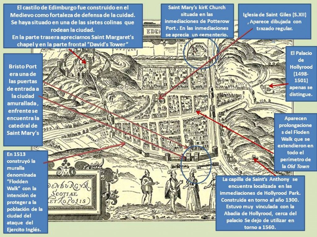
Como principales acontecimientos, cabe destacar que los siglos XVI y XVII marcaron una de las épocas más tristes y lúgubres en la historia de Edimburgo, cuando la población fue afectada por las continuas luchas contra los ingleses y hubo de construirse una muralla que rodeara la ciudad con el objetivo de proteger la misma de posibles invasiones. La construcción de esta muralla supuso una limitación al crecimiento de la ciudad y obligó a los habitantes de Edimburgo a construir edificios con grandes dimensiones de altura, llegando a haber edificios de hasta doce plantas, e incluso construyendo casas de madera sobre otras ya edificadas. Estas condiciones, sumadas a la influencia de otros factores, llevaron a Edimburgo a transformarse en un lugar en el que residían miles de personas, sin condiciones higiénicas suficientes, plagas, pobrezas, enfermedades contagiosas, incendios etc. Sin embargo, esto no supuso una disminución de la sociedad sino un aumento, llegando a contar con 50.000 personas en el siglo XVII.
Dado que la situación era insostenible, fue entonces en el siglo XVIII cuando se inician los planes para la construcción de una nueva ciudad. El encargado de dicho proyecto sería James Craig quién se hizo cargo del proyecto por concurso público. En este mismo período, la existencia de las murallas se hizo ya innecesaria debido al Acta de Unión que se firma entre Escocia e Inglaterra. Es en el siglo XIX, época de la imagen, cuando se dan por finalizadas las obras de la Ciudad Nueva, dando como resultado a la creación de varios monumentos como el de  Walter Scott, la acrópolis de Calton Hill y la Galería Nacional.
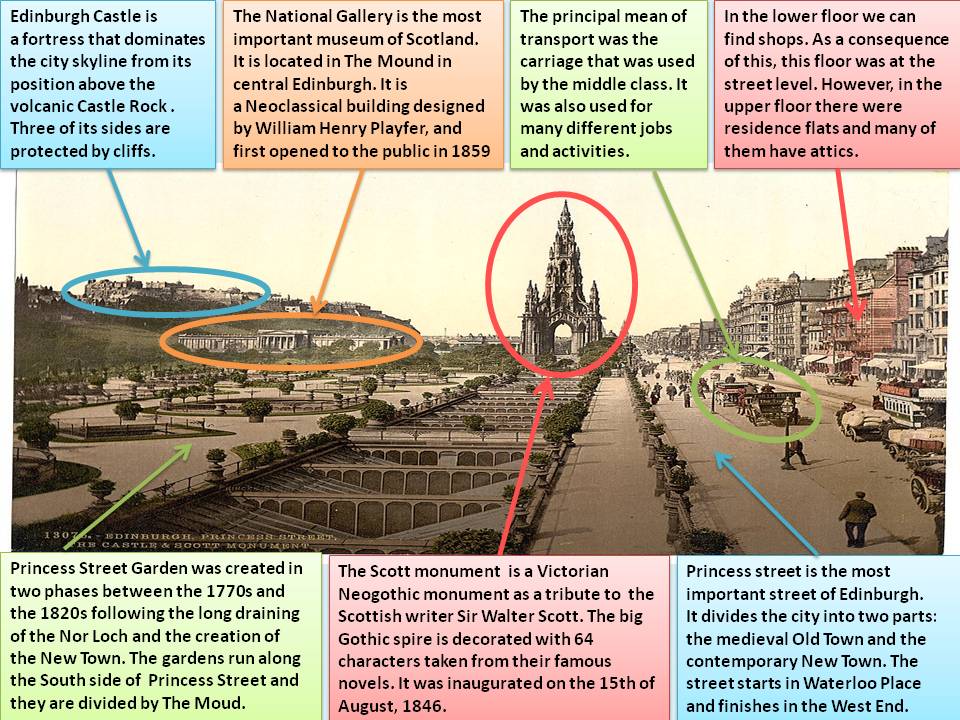
En lo referente a la estructura, en la presente imagen destaca, en la parte izquierda de la misma el casco histórico de origen medieval, conocido como “Old Town”. En el lado opuesto, o en la parte derecha de la imagen se aprecia la ciudad nueva o “New Town”, la cual se podría definir como el ensanche ya que se trata de una zona ampliada de la ciudad en el siglo XIX. En cuanto al trazado, se puede decir que en sus inicios la ciudad vieja o “Old Town” albergaba un plano lineal, en el cual el eje central seria la conocida calle “Royal Mile”. La cual empezaría con el Castillo de Edimburgo y finalizaría con el palacio de Holyrood. Por otro lado, en cuanto al trazado de la ciudad nueva o “New Town” la distribución de la misma tendría que ver con el plano ortogonal, ciudad formalista y geométrica opuesta al origen medieval de la ciudad antigua. Esta ciudad nueva, cuenta con una gran calle central, seguida de dos calles paralelas, la zona residencial de dos grandes espacios verdes, que se corresponderían con dos grandes parques.
Entre los elementos urbanos más importantes, destaca la calle “Princes Street”, que constituye el eje principal de la ciudad nueva. Esta calle, marca la separación y diferenciación entre ambos espacios. En la ciudad antigua uno de los elementos urbanos que destaca es el castillo de Edimburgo, pero, en la imagen, se pueden apreciar otros edificios como la catedral de Saint Giles y la torre de Hub. Otro de los elementos que se puede apreciar, es el puente “North Bridge” puente que comunica y permite el acceso de ambas ciudades favoreciendo así la unión entre ellas. Aludiendo de nuevo a una de las calles principales, cabe considerar que las principales actividades económicas de la ciudad tienen que ver con el sector terciario o de servicios, ya que en estas calles principales, albergaban los principales comercios o locales, los cuales prestaban todo tipo de servicios a los habitantes,  además de despuntar en ella el sector financiero y de la banca. Del mismo modo, debido al poder cultural de determinados edificios, así como la creación y separación de la ciudad en dos, se incrementó la actividad turística y de la construcción.
Después de haber analizado la imagen, se puede concluir la influencia de diversos factores históricos, políticos y económicos que llevaron a muchas de las ciudades europeas a distribuciones como la que se ha analizado y estudiado a lo largo de este artículo.
Leticia González García

05/7/13

EDIMBURGO (John Fulleylove, siglo XX)

Esta obra denominada Edinburg pertenece a una edición de 1904, ilustrada por el pintor John Fulleylove, que a través de veintiún grabados nos permite apreciar cómo era a principios del siglo XX la ciudad de Edimburgo. Se convirtió en un artista de acuarela y aceites en 1883. En cuanto al cuadro, es característico del impresionismo, cuyo principal objetivo es captar una representación del mundo espontánea y directa. Hoy en día, muchas de las obras de John Fulleylove son utilizadas por revistas y sitios web especializados como la página web Odisea2008.

Edimburgo es la capital de Escocia, ubicada en la costa este a orillas del fiordo del río de Forth.  Esta ciudad fue uno de los centros más importantes en educación y cultura durante la era de la Ilustración, gracias a su Universidad. Además, los distritos The Old Town and New Town, fueron nombrados Patrimonio de la Humanidad en 1995.

El histórico centro está dividido en dos zonas por los Princes Street Gardens, jardines construidos en 1916 en lo que era el pantano Nor´Loch. En una de las dos zonas se encuentra el Castillo de Edimburgo y la larga franja de Old Town, que representaría a la zona antigua, preservando una estructura medieval y muchos edificios de la época de la Reforma protestante. Por su parte, en la otra zona, se encuentra el New Town, zona nueva que alberga las oficinas de importantes bancos y empresas, además de ser sede de lujosas tiendas y comercios.

En cuanto al trazado de la ciudad, ésta se apiña en torno a la Royal Mile, una calle  de la que salen estrechos pasadizos y las calles denominadas Closes o Wynds, que encaminan colina abajo hacia los dos lados de la calle principal, denominada Princes Street, en forma de encrucijada. Otro sitio de interés serían las calles subterráneas, que evidencian antiguas clases de construcción.

En cuanto al plano urbano, se puede diferenciar como en la zona antigua y la zona nueva muestra planos urbanos diferentes, mostrando el Old Town un plano irregular y el New Town ortogonal. Esto se debe a causa del escaso espacio del Old Town, lo que provocó que se convirtiera en una de las primeras ciudades con apartamentos o edificios en altura. Pasando a tener  antes de la construcción de edificios una población de 80.000 habitantes, a 20.000 después de la construcción. Ante esto, se vio la necesidad de construir un mayor número de edificios y residencias situadas fuera de la muralla defensiva, que rodeaba el Old Town. Desgraciadamente, gran parte de estos edificios fueron destruidos por el Gran Incendio surgido en 1824, y su reconstrucción provocó cambios en el nivel de terreno, lo que llevó a crear varios parajes y calles debajo de Old Town, creando como hemos nombrado anteriormente, calles subterráneas.

Soraya del Fresno
 

04/20/13

EDINBURGH (19th century)

The city represented in this picture is Edinburgh in the 19th century; we can observe the principal street of the city, Princess Street. It is hand water colored print of the city engraved by Dosso. The picture is offered to the public in La Galerie Napoleon, a Parisian antique dealer specialized in antique prints.

The first knowledge about the settlements in Edinburgh is in the roman era (there are metallic objects and ceramic of the late first century). Edinburgh was not the capital of Scotland until the end of the middle Ages; before that, the capital was in the place where the King and his court were. In the Middle Age, Edinburgh began as a small fort but in the 18th century, the Englishmen arrested it and called Einden´s burgh (burgh is a word that formerly meaning strong). Finally in the 10th century the Scottish recover this part of Scotland. At the end of the 11th century, Malcolm III built the castle in Castle Rock and built a small village around it. In that century there is knowledge about Edinburgh being a true hamlet, which its main activity was trade. In this era, friars also appeared. They could go out of the monastery for working or other tasks, always entrusted it by their supervisor. In Edinburgh there were two orders, the Dominicans (with black clothes) and the Augustinians (with grey clothes). Both lived in the South part of Edinburgh.

In the 15th century Edinburgh was declared capital of Scotland and the King built the first Palace of Holy rood. In the 16th century the Flooden Wall began to be built, this was the wall that surrounded the city with the intention of protecting it from the English. There was a problem, the city had a big wall but also a big population, so the only way to build the city was using height. In 1767 the planning of the New Town began, in this epoch monuments were erected like Calton Hill, The National Gallery, and the Walter Scott monument.

The picture represents the main street, Princess Street; it starts in Waterloo Place and finishes in the West End. This street was built in the 18th century, during the reign of George III, and divides the city in two parts, the Old town and the New town. We can observe in the left of the picture some beautiful gardens, but before this, that area was the most important loch in Edinburgh, the Nor Loch.

This loch, at the beginning was a marsh, and it was used like a natural defense for the city and the castle. Edinburgh had the North and the West part protected, and only walls were required at the South and the East part. Then the North Loch started to get dry and in 1820 the Princess Street Gardens were inaugurated. Nowadays the gardens are the most important park in Edinburgh. These gardens also divide the Old Town and the New Town. In this part we can also observe the castle; it was the first fortress for protecting the city. Under the castle we see the National Gallery; in this moment it was in construction. In the middle of the picture we can observe the Scott monument (it was inaugurated in 1846). It is a Gothic building in honor of the Scottish writer Sir Walter Scott. The builder was George Meikle Kemp, he was joiner and draftsman and self-taught architect. The monument has a black color with a sinister aspect. The big Gothic spire is decorated with 64 characters of their novels. Finally at the right side of the picture we can observe different people walking through Princess Street, the principal street that divides the Old and the New Town. We can also see transports like carriage; it was the principal way of transport of the middle class.

In the 14th century trade began to increase. Edinburgh began to be famous for its clothes of wool. The export of skin besides started in the Leith port, the cattle was sold in Cowgate and the cereals and wheat were exchanged in Grassmarket. With the New town, the population of Edinburgh grew because Scotland began to have a political and religious activity, and a big economic development. The entire city was built around the Castle. Nowadays with the big population the Castle is not in the middle, but it still is the main structure. In the old part the streets do not have a regular structure, but in the new part everything is built in an orthogonal way. That is why we find a regular and lineal structure in all the streets.

Esther Rodríguez-Rabadán Mateos-Aparicio
 

04/10/13

EDINBURGH (AK Johnston, 1852)

This image is an engraving which is included in the book ‘Old & New Edinburgh’ 1890, which deals with the history of the Scottish city of Edinburgh. It is a lithograph of AK Johnston issued in 1852 that represents a section of the Royal Mile in Edinburgh. AK Johnston (1844-1879) was a young and dedicated geographer who studied in the Edinburgh Institution and Grange House School. Johnston, at the beginning, was superintendent of the drawing but in 1868 he was chosen a life member of the Royal Geographical Society. In June 1869 he was assigned to be in charge of the geographical department of the London branch of Messrs. W. & AK Johnston business. In 1878 he was appointed leader of the expedition of the Royal Geographical Society.

Edinburgh is the capital of Scotland (UK), located on the shores of the River Forth and the East coast of Scotland; it is also the headquarters of the Scottish Government. Something that  should be noted about Edinburgh is that the Old Town and New Town were awarded World Heritage by UNESCO in 1995. Edinburgh has 477.660 inhabitants but when its famous international festival is celebrated, this number is doubled. Edinburg was one of the most important centers of education and culture during the Enlightenment thanks to the University of Edinburgh. As I said before, Edinburgh is divided in two parts: the Old Town and the New Town.

The Old Town (as it is shown in the picture) has the same medieval structure and a lot of buildings from the protestant reform. In that place of the city we can highlight some squares, St. Giles Cathedral, the university of Edinburgh, museums and various subterranean streets… but one of the most important buildings of the city is its Castle ,which is located at the top of the hill that is communicated by the High Street. This Old Town was the first city of houses and apartments located on a high relief.

The New Town appeared as an answer to the overpopulation of the Old one in the 18th   Century. There was a contest to design the new map of the city in 1766. Finally, James Craig, who was a young architect, was the winner. He made an orthogonal planning in which its main streets would be Princes Street, which is nowadays an important shopping place, and Queen Street.

This image belongs to a section of the Royal Mile. The Royal Mile is a succession of streets that communicate the Castle of Edinburgh to Holyroodhouse Palace. This avenue is divided in four parts or places: Castlehill, Lawnmarket, High Street and Canongate. We can appreciate two of the parts in the image: Lawnmarket and High Street. The bottom of the picture corresponds to Lawnmarket, which is a part of the Royal Mile designed for trade. Lawnmarket was originally on High Street and it was a place where they sold thread, cloth, and linen wear. This zone was also called Inland Merchandise and the merchants put their stalls and tents to sell their fabrics in the sides and in the middle of the street. Lawnmarket is situated at the bottom of the picture. As I said before, the image presents a medieval structure, and we can appreciate, in the bottom of the picture, different commercial activities. Finally we can highlight some people in this part of the picture; it seems that they are carrying out the commercial activities of the time.

High Street is the main issue of this graving. This is the avenue that goes from the Castle to the Palace. In this street (in the picture) we have to highlight Old Tolbooth (the old municipal prison) and St Giles Cathedral. Old Tolbooth was a prison where executions and tortures were something common in that era.  The North Berwick witches trials were brought here and the prisoners sometimes wore iron collars for chaining up offenders in public view. The prison was demolished in 1817 because it made the High Street very narrow and promoted an unhygienic environment. Instead, in its place, a heart shape formed by paving stones was put on the floor marking the entrance of the old building. This heart is known as the Heart of Midlothian (the title of the graving). Another important building is St Giles Cathedral that is shown in the image.

St Giles Cathedral is the main place of worship of the Church of Scotland in Edinburgh. It was a very important religious place during the last 900 years. Today it is the Mother Church of Presbyterianism that is focused in St Giles, the patron of the city. In 1877 the Cathedral was divided into three different churches, one of them was the Thistle Chapel which was built in 1911 at the South-East corner of the church, that presents great and extraordinary details.

Laura Cabrera Sanz

10/27/12

EDIMBURGO (Braun – Hogenberg, 1574)

Esta imagen corresponde a un grabado de la ciudad de Edimburgo en el siglo XVI, durante el reinado de Jacobo VI. Está dibujado desde un punto de vista elevado que permite mostrar casi una vista aérea de la capital escocesa. Sus autores fueron Georges Braun y Franz Hogenberg, quienes lo publicaron en una edición de 1574 del atlas Civitates Orbis Terrarum, denominada en francés Theatres des Cites du Monde.

Evidentemente, el grabado nos muestra la visión de una ciudad preindustrial, con un recinto  amurallado donde aparecen las diferentes puertas de entrada a la misma. La muralla era conocida como “Flodden Walk” y se construyó con la intención de proteger a la población de la ciudad del ataque de los corsarios ingleses. Al sudeste de la ciudad aparece la Puerta de Bristo, en las proximidades de San Mary’s Cathedral, y en la parte izquierda otra de las principales puertas de acceso. Entre la trama urbanística podemos apreciar una calle de larga longitud denominada «Milla Real», que es una de las calles principales de la ciudad. En la parte central de la misma aparece la iglesia de Saint Giles, de época medieval.

El plano de la ciudad de Edimburgo corresponde a un trazado de calles más o menos regular, aunque existen numerosos callejones sin salida, patios interiores y otras irregularidades. La mayor parte de las calles son estrechas y están situadas en pendiente, incluso hay numerosos callejones situados en el corazón de la actual Ciudad Vieja, así que la morfología medieval está fuertemente conservada. Por otra parte, en Edimburgo el Renacimiento no tuvo tanto auge como en otras ciudades importantes de países como Italia o España.

Entre los elementos urbanos más destacados se distingue en la parte superior izquierda un castillo, situado encima de una de las siete colinas de la ciudad, que era sede de la corte escocesa. En la parte derecha podemos ver el entramado de la construcción del palacio de Hollyrood, que fue realizado entre 1408 y 1501. Posteriormente, fue ampliado por Jacobo VI y se convirtió en el monumento por antonomasia de la dinastía de los Estuardo. En los comienzos de su construcción, la población que vivía en la cercana aldea de “Canongate” fue desplazada hacia otras zonas de la ciudad. Abajo a la parte izquierda podemos apreciar la Capilla de San Antonio, construida a comienzos del siglo XII, que comenzó a caer en desuso en 1560.   

En el siglo XVI los comerciantes y artesanos se apiñaban en pequeñas viviendas en las inmediaciones de la Royal Mile, mientras que fuera de la muralla se encontraban las casas de los granjeros y campesinos. En aquella época la ciudad de Edimburgo estuvo marcada por las continuas epidemias de peste, a pesar de los cual se produjo un considerable aumento de la población. Edimburgo tenía aproximadamente 12.000 habitantes y a lo largo del siglo XVI la población creció hasta los 15.000 habitantes. En esta época se produjo en la ciudad un avance en el estudio de la medicina, gracias en parte a la fundación del Surgeon College, un centro de estudios médicos antecesor de la Universidad de Edimburgo, que fue fundada posteriormente, en 1588. Gracias a la introducción de la imprenta, hubo un importante aumento de las publicaciones.

La economía de Edimburgo estuvo marcada por un fuerte crecimiento durante la dinastía de los Estuardo. La actividad económica de los burgos fue creciendo muy lentamente, produciendo un considerable aumento de la población en la ciudad.  Se fundaron nuevos burgos y granjas en las inmediaciones, diversificando las actividades económicas. Además,  se construyeron nuevos caminos que unían la capital con poblaciones mucho más cercanas, pero el trasporte más eficiente era por mar debido a las condiciones climatológicas adversas predominantes en la ciudad. También se construyo una gran flota pesquera que permitió que los burgos escoceses comercializaran sus productos con el norte de Europa, exportando entre otras cosas arenques, lana, pieles, cuero, telas, sal y carbón.

Antonio Morillo Carreño