06/5/18

CRACOW (Hartmann Schedel, 1493)
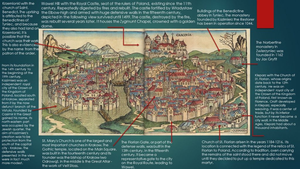

The historical view made by Hartmann Schedel is a woodcut from «World’s chronicle’». It shows the sketch of medieval Cracow and accompanying cities Kazimierz and Kleparz. Within Cracow’s walls Hartmann draw Wavel hill with Wavel castle. From this point to Main Square leads Grodzka street. In the Main Square, topped with two towers, St. Mary’s basilica. Buildings in Cracow fill all the space of town. In right down corner – Kleparz. Independent city with St. Florian’s church. Above Kleparz monastery of Norbertanki in the Zwierzyniec. View shows also buildings of benedictin’s abbey in Tyniec. On the left side Kazimierz, separated by big walls which in reality were smaller.  Above Kazimierz Krzemionki with St. Benedict’s church. It is the oldest view of «Cracow tricity’». It is a copy of reproduction from collection in State Archives in Cracow.
Located in southern Poland on the Vistula River, the city is located at the confluence of several geographical regions: the Krakow Gate, the Oświęcim Basin, the Sandomierz Basin, the Westbeskid Foothills, and the Krakow-Częstochowa Upland. Its origins are associated with folk legends, later it was a princely, royal city, prosperity and prosperity provided by masses of craftsmen, and artists and scientists contributed to the development of culture and science. The remainder of the former inhabitants of the area of Krakow are two mounds, which may have been places of religious worship, although their destiny is not completely known. They are a mound of Krakus and Wanda. The convenient location on the Wawel Hill and near the Vistula River encouraged permanent settlement. Other residents came to this place, and Krakow slowly became important in the face of other Polish cities.
During the reign of Bolesław Chrobry, a bishopric was established here and the construction of the Wawel cathedral began. The versatile development of the city was conducive to the desire to learn about the city’s origins, which was first described by Wincenty Kadłubek in his chronicle. In 1241, during the Tatar attack on Poland, the first invasion of Krakow took place. The result of this assault was almost total destruction of the city. Already in the twelfth century, a library and cathedral school operated in Kraków, which was considered the best university in Poland at that time. The center of the city was the Wawel Hill, around which numerous scattered merchant and craft settlements were created.
In the urban development of the city of Krakow one can distinguish the following phases, from the natural system, then the checkerboard, through the bypass-radial system, the grid-band system up to the new bypass-radial system with four bypasses. It was not until 5 June 1257, during the reign of Bolesław Wstydliwy, that Krakow was granted a privilege of location under the Magdeburg Law. Thanks to it, there was a chessboard layout of the city, the burghers were exempt from paying taxes for a period of 6 years, they gained the right to fish in Wisła, the commune got the right to own taverns, slaughterhouses and mills. At that time, the Main Market Square was also created, which is the pride of Krakow until today. In 1333, King Casimir the Great crowned Wawel. In 1335, he located a new city in the immediate vicinity of Krakow named after him – Kazimierz. King Casimir the Great made a huge contribution to the development of Krakow and the surrounding area. Thanks to him, trade flourished here, thanks to which the city gained a lot of income and the inhabitants became more and more wealthy. Also many buildings were erected today which are the largest monuments of the city, including Wawel castle. King modernized the city’s fortifications, paved the streets, and founded waterworks.
With the expansion of the city grew its importance. However, the most important event during the reign of Casimir the Great was the founding of the Krakow Academy in 1364, which was the first Polish and one of the most renowned universities in Europe. In the fifteenth century, Krakow experienced cultural and scientific development. Here, among others was taken by Nicolaus Copernicus, an outstanding astronomer, author of the work On the Revolutions of the Heavenly Spheres. At that time Wit Stwosz, a great sculptor, created an altar in the St. Mary’s church.
In 1493, when the view of Schedela was created, Krakow was already a city with rich medieval buildings. During the reign of Władysław Jagiełło, Wawel was clad in huge defensive walls, which are much lower today. Today’s districts of Krakow, Kazimierz and Kleparz, were separate cities with their own defensive walls. Krakow separated from Kazimierz the non-existent branch of the Vistula, which was the natural border between the cities. Krakow is one of the oldest Polish cities with many valuable architectural objects. It has many institutions and cultural institutions gathering priceless monuments. For many years, the capital of the state became a power, towering over many cities of the Polish-Lithuanian Commonwealth and distinguished itself not only by its architecture and heritage, but also by a centuries-long history that in retrospect gives this city prestige and heroic glory.
Monika Łękawska tutored by Dr Natalia Bursiewicz
06/5/18

WARSAW (Joris Hoeffnagel, 1586)


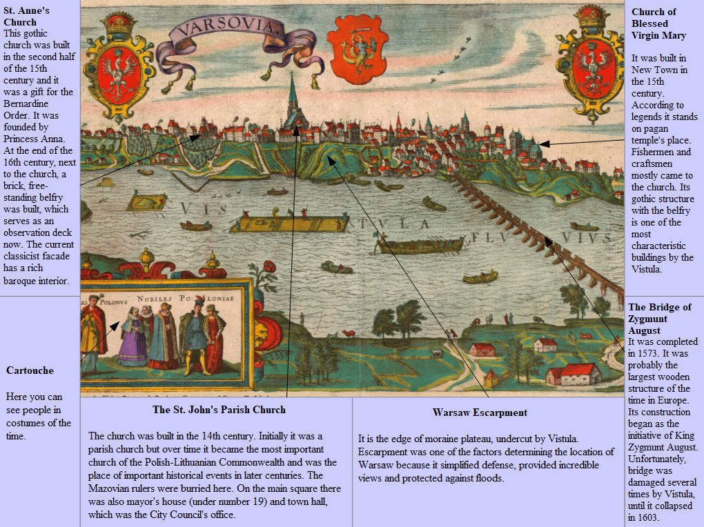
This view is an engraving. It was made in 1586 by Dutch artist Joris Hoefnagel. The view was placed in the sixth volume of atlas of world’s cities ”Civitates Orbis Terrarum”, published in Cologne by Georg Braun and Frans Hogenberg. Warsaw is the capital of Poland and masovian voivodeship. The metropolis stands on the Vistula in east-central Poland. The vecinity of Warsaw was formed by glacial processes. The significant element of landform, undercut from the east by Vistula, is the edge of moraine plateau called Warsaw Escarpment.
The city rose at the turn of 13th and 14th centuries and it was located under the Chełmno Law. However the location document has not preserved. The prince Bolesław II, who is considered the founder, brought from Toruń the group of wealthy merchants. They were lokators and they named the city Warszowa. This early form derived from the name of knight Warsz from Rawicz family. The construction of the city began from creating specific urban layouts dependent on topographical conditions, inhabitants’ needs and size of the main square. The plan was created by professionals and it is typical for cities located under German law. City boundaries and the place for church were demarcated and symmetry of city plan was accepted. The wealthy lokators made the city was surrounded by walls from the land quite early. Demarcated main square was relatively small because no big hopes were placed on city’s development. Two perpendicular streets ran out from its corners. The longer side was parallel to Zakroczym-Czersk Way, which was the most important way in the city. 40 building lands were
demarcated around the main square.
The main square had a functions of as agora and meeting place. There was a mayor’s house too. The gothic town hall, which was the City Council’s office, was built at the beginning of the 15th century. With the founding of the city, the St. John’s parish church was established. Over the years the Warsaw’s economic and political significance was growing. A special rise took place under the reign of Prince Janusz I the Elder who established Warsaw as the capital of the Duchy of Masovia. The city was enclosed with a double wall topped with towers and protected by a moat. A gothic building, the seat of a Prince, was on the escarpment. It was built in 15th century and was called the Great House. There were courts and a chancellery next to it. The St. Martin’s church and monastery and the Holy Spirit’s Hospital for poor old people were built near the western part of the walls. Within the walls were: a prison in the Marszałkowska Tower, two cemeteries at the back of parish church and the bath near the Nowomiejska Gate. The burgher houses were initially wooden but later they were replaced with brick ones. At the beginning of the 14th century to the north of the Old Town, the New Town came into existence. It was inhabited mainly by craftsmen and merchants. The city was not limited by walls and it was founded on regular plan with main square in the center. Two buildings were distinguished: the St. George’s church and monastery and completed in 1411 church of Blessed Virgin Mary. In the mid-fifteenth
century Princess Anna founded St. Anne’s church and the bernardine monastery.  
An important event in taking over the privileges of other Masovian towns by Warsaw was the end of the Duchy of Płock. In 1529 a general sejm took place here. In the second half of the 16th century Warsaw took over the role of place of royal elections. In 1568 the construction of a wooden bridge over the Vistula began as on the initiative of Zygmunt August and Anna Jagiellonka. Previously, there was the ferry crossing or people were building temporary bridges. However, the frequent visits of the king in the city and choosing Warsaw as a place of parliaments initiated the construction of probably the largest wooden structure in Europe. The construction was managed by Erazm Giotto, a burgher from Zakroczym. A work was supervised by Zygmunt Wolski, a Warsaw starost and the priest Kasper Sadłocha was responsible
for finances. The construction was completed in 1573. The Bridge Gate was on the abutment. The bridge has served residents and visitors for 30 years, was demaged several times by Vistula, until it finally collapsed. In those days it had to make a great impression on the people because Jan Kochanowski wrote a few epigrams about it.
Monika Górowska tutored by Dr Natalia Bursiewicz
 

06/5/18

STETTIN – SZCZECIN (Braun&Hogenberg,1588)


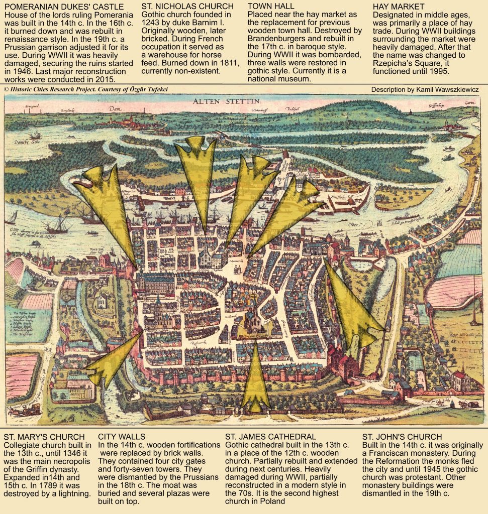
Stettin was originally a Slavic stronghold founded on the left bank of the Oder River, about 150km north-east of Berlin. The oldest traces of the settlement are dated back to the late 9th century. The population was pagan, out of four temples the most important one was the temple of Triglav. From 12th to 17th c. Stettin was ruled by the House of Griffins. The first Christian temple build in the settlement was the church of St. Peter and Paul. In 1243 Barnim I, Duke of Pomerania presented Stettin with town privileges. The original wooden fortifications were replaced by sturdier stone or brick walls in the 14th and 15th century.
Stettin, like most marine cities was focused on trade. It started by allowing inland settlements to sell their goods to foreign merchants and vice versa. With the growth of prestige and wealth the range of the trade could be expanded. In the late 13th c. Hanseatic League established an agency in Stettin. The city traded mainly with Denmark,  Magdeburg and Poland. Polish king Władysław II Jagiełło granted the city trade privileges in 1390, Stettin became one of the main export routes from Poland.
The attached map is dated to 1588, when the first edition of Civitates Orbis Terrarum was released. The 16th c. was a time of changes for the city. The decline of Hanseatic League in the region caused by growth of English and Dutch merchants forced the city to become more self-sustaining. Agricultural and forest industry flourished, soon Stettin did not have to import raw food. It actually become one of the biggest exporters of food in Pomerania. Since the end of the 15th c. it was a capital of the Duchy of Pomerania. Increasing prestige of the city attracted many craftsmen, numerous guilds were established as the result. Neighbouring settlements, such as Gartz, Greifenberg and Stargard supplied the city with raw resources and brought back craft products, sea fish and imported goods like cloth. Stettin had a dockyard but it constructed ships mainly for local merchants, selling new units to foreigners was forbidden by law.
In the 16th c. the size of the city did not change much. The main settlement was still contained in medieval walls, although the agglomeration included also three minor settlements. Total population probably oscillated about 17 000 people. One of the most notable changes was reformation. Duchy of Pomerania became protestant which resulted in expulsion of the monks from the city.
Kamil Wawszkiewicz tutored by Dr Natalia Bursiewicz