05/22/14

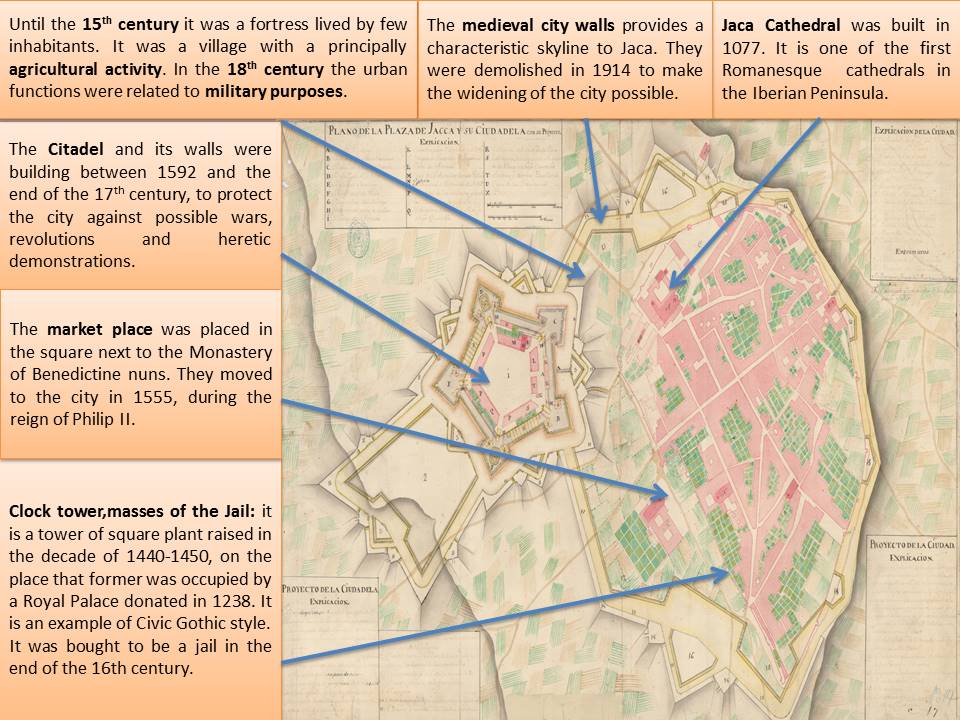
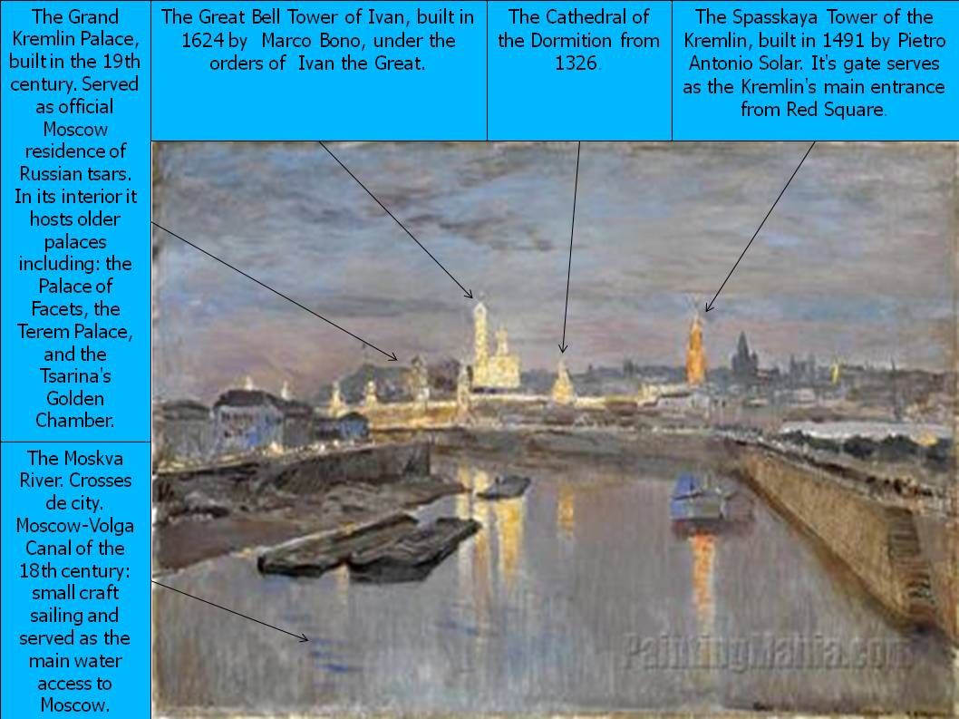
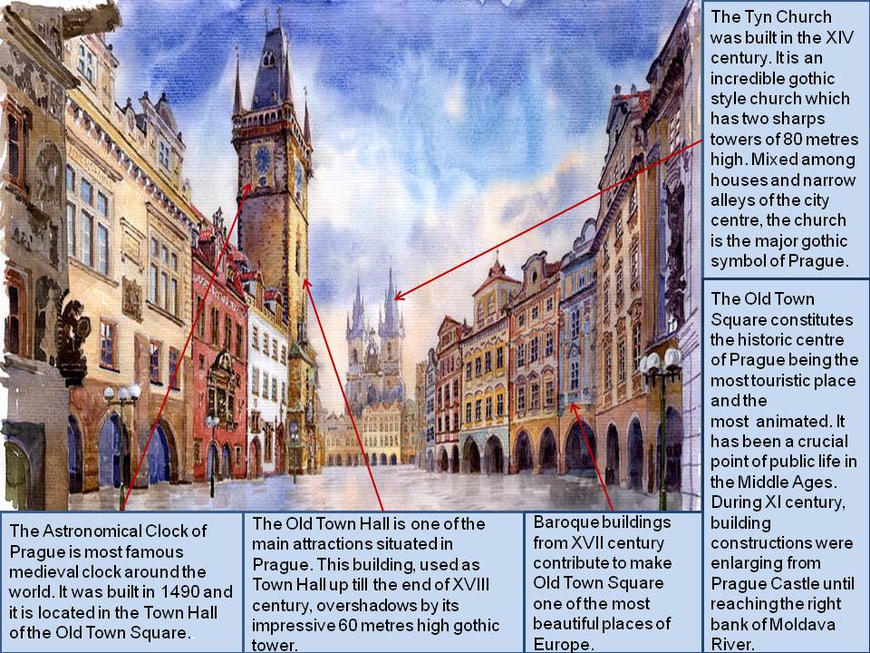
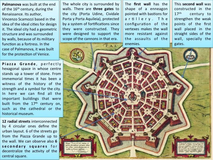
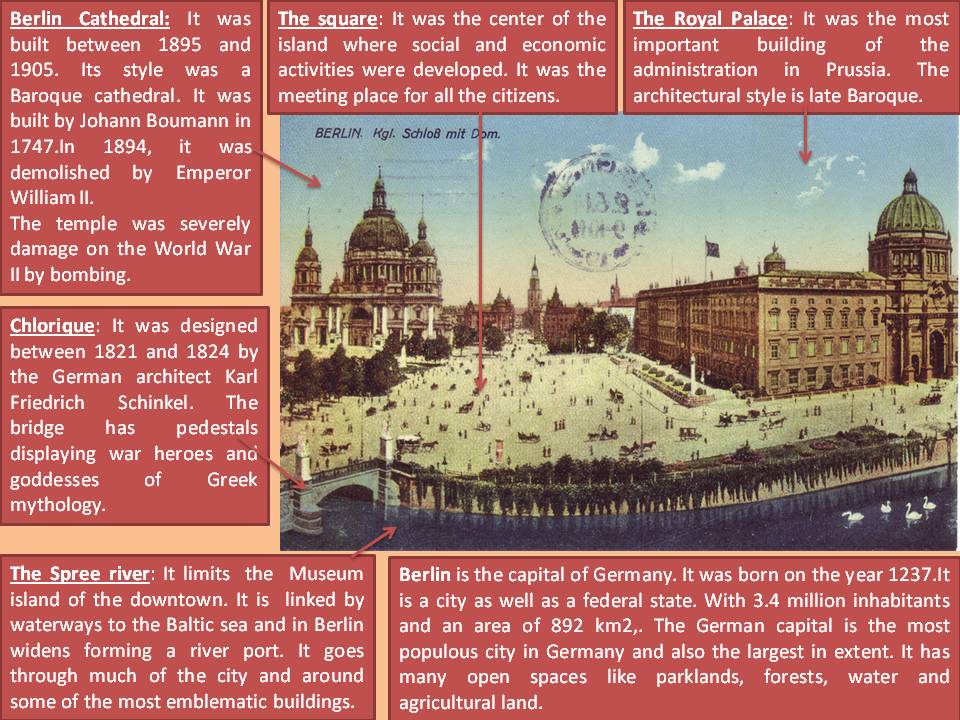
BRUGGE (Marcus Guerards, 1562)

Bruge Main Characteristics

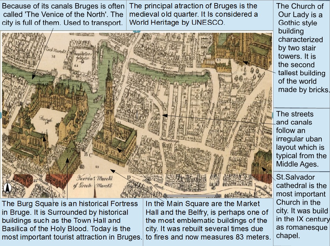
I have based my essay on a map made by Marcus Guerards in 1562. Some prints, as well as the original copper plates, are found in the print room at the Stedelijk Museum of Amsterdam. The complete map represents the medieval old quarter of Bruges although I focused only on a part of the old town in order to describe it in a more detailed way.

The name of Bruges comes from Old Norse «Bryggia» (bridges, docks, piers). Interestingly, in the Flemish language «Brug» means «bridge», and this city takes as name the plural word due to the large number of bridges that exist in it.  It is located in the northwest of the country. At first, its top was a coastal city, but the constant sedimentation caused its separation from the sea, and Bruges became a canal-based city. These canals have been used for transport and trading purposes.

The work of art that I have chosen has a lot of details that allow us to analyze the structure of the city: its structure is based on an irregular plane formed by the streets and canals, and the principal streets flow into the main square. The main buildings are located in the center of the Old Town. Most of them are built in Gothic style, which is the prevailing architectural style of Brugges. In the upper right corner is located the Church of Our Lady that is the second tallest building in the world made ​​with bricks. Built in the 13th century, it is characterized by its two stairs towers and its wealth in works of art. Further down in the right margin we found St. Salvador Cathedral. It was built in the ninth century as a small Romanesque chapel. Throughout its history, the cathedral has been influenced by many different styles: Romanesque, Gothic, Flamboyant Gothic and Neo-Gothic. Nowadays, it is the most important church in the city and the seat of the bishop of Bruges.

The main square, in the centre of the image, contains the statues of the local heroes Jan Breydel and Pieter, the Belfry and the covered market, that was used to sell mainly wool and clothes. The Belfry used to be an administrative center and watchtower, and it has been destroyed by fire and restored several times. Finally, at the left of the image is found the Burg square, surrounded by various historic buildings such as the City Hall and the Basilica of the Holy Blood. This 12th century basilica consists of two chapels: the lower one, dedicated to St. Basil the Great, is a dark Romanesque structure that remains unchanged; the upper chapel was rebuilt in Gothic style during the sixteenth century and renovated multiple times during the past two centuries, and it contains the venerated relic.

The Historic Town of Bruges is a well-known example of medieval architectural ensemble, that has maintained its historic structure as this has evolved over the centuries. Little streets, an intricate network of canals and original Gothic constructions form part of the town´s identity. Its importance has been acknowledged by UNESCO, that included Bruges in the World Heritage List in 2000.

Antonio López Burgos

05/21/14

JACA (18th century )

imagen

This plan represents the city of Jaca (Huesca) in the 18th century. It is a city of northeastern Spain near the border with France, in the midst of the Pyrenees in the province of Huesca. The image centres its attention on The Citadel and the old quarter of Jaca which is a medieval Christian city. It is a manuscript drawn in black ink and colored with water-colours in red, green, grey and yellow. It belongs to the Historical Military Service in Madrid.

In the image we can appreciate that the urban layout is irregular, which is typical in medieval cities, because the streets don’t have a regular order and the squares don’t have a rectangular shape. 25 years ago were realized in Jaca the first archaeological excavations of this urban area, which turned out to be crucial for the later historiography. The findings propitiated the rediscovery of the Jacobean Jaca, which was a very important town in the Middle Ages due to its location in the Way of Saint James. The influence of the Way of Saint James was not only noted in a number of works of art but also in the religious, cultural and economic aspects in relation to this network of peregrination.

It is curious to note that the main square in Jaca was named “castrum” in ancient texts. At the beginning of the 11th century Jaca was a hopscotch or military camp formed by a set of housings with a significant importance thanks to its situation. Furthermore it was one of the most accessible paths to France and a strategic entrance for the Way of Santiago. This is something that can be appreciated in the urban structure of Jaca as we can distinguish two main areas: on the left there is a military fortress, whereas on the right it is possible to see the town itself surrounded by city walls.

King Philip II commissioned the engineer Tiburcio Spanochi to design this fortress which was named the Citadel of Jaca. It was built between 1592 and the end of the 17th century. It is a pentagon with thick slightly inclined stone walls, which are reinforced by a bastion at each point and surrounded by a moat. The most important military activity that has taken place there was during War of Spanish Independence, when it was occupied by French troops between 1809 and 1814. The Citadel, also called Saint Peter’s Castle, now houses the Museum of Military Miniatures with a collection of more than 32,000 pieces.

Another important urban feature is the Cathedral, which was declared a National Monument in 1931. Its construction began in the late 11th century during the reign of Sancho Ramirez. The Cathedral maintains its original Romanesque structure and layout but nowadays the building is the result of constant modification, extension and demolition. Saint Peter’s cathedral is an open book, a voyage through history and evolution of art, from the first expressions of the Romanesque style to the artistic tendencies of the late 18th century.

A remarkable historical event that happened in this city was the death of King Alfonso I. As a consequence, the Kingdoms of Navarra and Aragon were separated and therefore some rivalries arose between them. In 1137 and 1141, fires occurred in some boroughs, so its city walls were reinforced and Jaca began to have an important military role. Due to its geographical situation, Jaca was also a city-market and provided a lot of services for its region. Also, it was like a final stop along the route from Zaragoza to France and the city council received one of the five tolls that travellers had to pay.

Today Jaca is a city that is open to the future. It proclaimed its interest in developing tourism back in 1917 when the city started growing. It is now a modern, cosmopolitan city with a varied cultural life attracting thousands of visitors every year. We should also mention that one of the best season to visit Jaca is winter, due to its offer of winter sports and climbing activities.

More info at:  http://www.portalcultura.mde.es/culltural/archivos/
Cristina Servet Alvarado

05/10/14

MOSCOW (Isaac Levitan, 1896)

ppt moscu

The Illumination of the Kremlin (1896), was painted by Isaac Ilich Levitan, a Russian painter fond of the beauty of the Volga region and its spirit. He narrated history through his painting, and that is why he captured the night of the celebration of Nicholas the Second coronation, reflecting the feelings that arose from the city, through its illumination. His style represents a bridge departing from realism towards impressionism. Through his art, he was able to reflect the characteristics which defined the Russian life.

The city of Moscow, capital of the Central Federal District of Russia, is the largest city in the country and one of the largest cities in the world. It’s located in the western part of the country and eastern from St. Petersburg. When it comes to topography, Russia has in its vast country, five different natural zones. Moscow is part of the European plain, or steppe zone. Most of the population is concentrated there due to the fact that it is one of the only habitable places for human life. Another important fact was that since the Industrial Revolution industries where located here, so that peasants moved towards the city looking for a job and hopefully for a better life. In the painting we can observe the Moskva River, which crosses the city of Moscow. It is a tributary to the Olka River which eventually flows into the Caspian Sea. It was and it is an extremely important resource for the city water supply. The Moskva River is hosted by the Moscow-Volga Canal, which at that period of time could only allow small craft sailing and served as the main water access to Moscow. Nowadays it serves as an important link for ships to travel to the north.

Although it is not visible from the painting point of view, the city has a radio centric morphology, imitating the shape of a spider web connecting the axis from the center to the outskirts. This urban layout begins at the Kremlin since it is the center of the city. This model was developed in the Middle Ages and it was centralized during the Renaissance. Since 1896-1897 to our modern time, the city has over gone tremendous changes, adapting poor neighborhoods (due to the great gap between rich and poor in Russia) into more modern, XX century ones.

The climate is a crucial factor to be taken into account, particularly when it comes to the materials used for construction. It is a continental humid climate that suffers exaggerated differences from summer to winter. These extreme conditions induced the use of materials such as stone and bricks in order to get more resistance against this brutal climate. It is important to mention that Moscow hosts an evolution of artistic movement, from Byzantine architecture, continuing with the Italian Renaissance movement, as well  as some Baroque churches, and finally in Nicholas I regime, they adopted the Neoclassical for the construction of major building like the Great Kremlin Palace.

This painting was made to honor the coronation of Tsar Nicholas II, so it is logical that one of the most emphasized spots was the Kremlin, a fortified complex in the center of the city. That makes it the core location for a number of important buildings such as cathedrals, palaces, government buildings, etc. The Grand Kremlin Palace is one of the most significant buildings you can find in the Kremlin area, and it was built in the 19th century. It was the official residence of the Tsars and it included older palaces inside its perimeters with walls surrounding them.We can also see the Cathedral of the Dormition, a significant Christian temple considering that the Orthodox religion was imposed in Russia at that time. And as we have seen in many examples throughout history, religion provides power so it’s obvious that the Christian leader (an orthodox priest) lead the ceremony, making it an exceedingly devoted event.

The conservative Orthodox Christian church has been a strong influence since 988 in every aspect of the Russian lifestyle, including architecture, social and economical aspects. In the Tsarist Russia religious icons could be found decorating, not only religious temples such as cathedrals, churches, but even the palaces and private rooms of the Tsars were filled with them. As a result, the Tsars coronation took place in the Kremlin Palace, heart of Moscow. And it was after the coronation banquet that the illumination of Kremlin began. This celebration, plenty of fireworks, operas, etc, was intended for the masses, as to make it seem a festivity and a reason of celebration to give more importance to this date.

Another of the most outstanding buildings, represented with bright gold and white colors in the image, is the Great Bell Tower of Ivan. The reason why Levin made such a big deal about this building in his work was due to the strong symbolism it had for the Russian people, which was survival under pressure. It became even more significant after the failing attempt Napoleon had to destroy it. A very important factor concerning the Russian population in that century was that most of them was poor, mainly peasants who barely survived due to the constant raise of taxes and fees, thus making it impossible for poorer classes to gain any education which resulted in a 79% of the population being illiterate. In 1896-97 the population was 1,038,625, most of it working class born from the Industrial Revolution. It was because of this revolution that new ideological movements arose that would cause the fall of Tsar Nicholas II.

Sara Levy Martínez
 

05/9/14

MUNICH (19th Century)

Munich ppt

The city I have chosen is Munich. I took the image from a vintage postcard dated in the late 19th Century and it is an aquarelle that shows the Max-Joseph-Brücke and at the back of the painting there is a panoramic view of the main monuments of the city centre. In the image we can also appreciate the Alps, the Isar River and the Englischer Garten. The name of the person who painted this image is unknown. The main street in the photo is called Maximillianstraße and the neighbourhood is the Innenstadt Nord. If we compare the painting with the current view in Google Maps, we can see that times goes by

The landscape around Munich is similar to other cities in Central Europe. The Alps mountain range is very close to Munich and this makes the climate quite cold in winter. It snows for about 4 to 5 months every year. There is also a weird phenomenon from The Alps called föhn, which is basically a wind that can come up in any season and brings shine and clear skies. Another geographical feature is the Isar River, which cross Munich. It is the fourth largest river in Bavaria. We can observe that the river is dividing the city into two parts. In the west side we find the Old Town. Its buildings were built during the first half of 18th Century in Baroque and Rococo style. Marienplatz is the main square of the city, known before as Schrannenmarkt (the marketplace). In the place we can also find the Neues Rathaus (19th Century). It is famous because of its carillon, the Glockenspielt. On the other side of the river we can find the modern part of the city. In this area there is a mixture between leisure buildings, gardens, baths, breweries, residences and houses. The city was Olympic Venue in 1972. As a result of this, there is a famous park in the outside of the city called Olympiapark.

During the middle ages, the centre of the city was surrounded by a city wall. Nowadays we still can see the four main city gates called Sendlinger Tor, Isartor, Schwabinger Tor and Karlstor. Firstly, the city was developed alongside the River Isar. Lately it presented a radio centric plan, which was well organized. From this nucleus the city start to grow and now it is composed by different neighbourhoods. The most important ones are Ludwigsvorstadt, Sendling, Giesing, Ramersdorf, Haidhausen, Bogenhausen, Schwabing and Maxvorstadt. They have a good network of subways that connect all of them and bike paths all around the city.

Munich is a city full of parks, palaces, museums, art galleries and his famous Theatre and Opera house. The inhabitants keep their old traditions. They use to dressing in ancient Lederhosen and Dirndl not only in the Oktoberfest but also when going to church every Sunday. There are many beer breweries in the city because the population love beer. The most famous tavern in the world is the Hofbräuhaus, which was inaugurated by the king William V in 1589. In this brewery you can also enjoy the traditional music of the Bavarian region and the typical Bavarian gastronomy such as sausages, knuckle of pork, crucrut and apflestrudel.

In the 19th Century the population of Munich was around 831,000 inhabitants. Nowadays the metropolitan city has 1, 34 million inhabitants and 300,000 of those are immigrants (Turkish, Albanians, Croats, Serbs, Greeks, Austrians and Italians among others). There are different social classes. The rich population live in little towns and residential areas around the city. The rest live in working-class neighbourhoods. Munich is mainly an industrial city. It holds very important companies like BMW, IBM, Alliance, etc. and is also one of the cores of the publishing industry.

The current image of the buildings in the city centre is due to a fantastic rebuilt after the Second World War because Munich was almost completely destroyed. Today it is the capital of the free state of Bavaria and has two important international authorities, which are the Federal Finance Court of Germany and the European Patent Office. Historically, Munich is also related with Adolf Hitler because here he began his assault to power, bursting into a meeting in the Bürberbräukeller.

Fernando Martínez Hernández
google maps geo ppt
 

05/9/14

ROME (Sebastian Munster, 1549)

roma 1

This image belongs to Sebastian Muster (1488-1552), cartographer, cosmographer and German Herbaraist. It is a map of the city of Rome in 1549, included in the book Cosmographie Universalis. Technically it is an engraving that follows the emptying wood technique and later printing in relief obtaining a sheet of simple aspect that later is coloured.

It is easy to appreciate how the city of Rome was and the huge monuments that were built in its area. The city is full of churches, basilicas and some castles. In the image, we can appreciate part of the urban layout of the city. On the one hand, the urbanistic structure of Rome must be considered as exceptional because it was set over a special topography formed by seven hills (Palatine, Aventine, Capitol, Quirinal, Viminal, Esquiline and Celio) in addition to an island in the River Tiber, called Tiberina. It was difficult to establish a regular plan in a place with so many slopes so that the urban layout is irregular and not all the streets are equal. There are two major streets that cross the city from one side to the other, and the rest are narrow, irregular streets. The quick increase of inhabitants (more than one million in the Imperial Era) provocked an anarchic growth. Those who had not money, used to live in the high zones of the city and the swampy zone that was in the centre turned into the forum where the principal public buildings were located. The poorest classes lived in narrow streets in the lowest and unhealthy zones or in the depredated neighbourhoods of the periphery and the port; this zone formed the city outskirts.

Regarding the buildings, one of the principal urban elements that we can appreciate in the image is the complex of Saint Angelo’s Castle and Saint Angelo’s Bridge. They both were connected to the Vatican and Saint Peter’s Church through three large avenues. The picture displays how Saint Peter’s Church stands out in the background near the castle. In spite of the popular belief, Saint Peter’s is not a cathedral, since Saint John of Letran Archbasilica is the real Rome cathedral. In the middle right we can find Agrippa’s pantheon that was built at the beginning of the Roman Empire (27 a.c). It was very important for the citizens due to it was dedicated to all Roman gods. The forum was one of the most important urban elements because in this area it took place the bustling activity as trade, business and social interchange. Below this point, there is the basilica of Saint John of Letran. It is located out of the limits of the Vatican area although inside Rome city and close to the city wall. In the bottom right it is possible to appreciate Aureliana Wall which has an original length of 19 Km. It has a hexagonal shape and is composed of 382 towers and 18 Principals doors. This city wall was built to defend the population against the Barbarians invasions. In the bottom left is the Diocleciano’s thermal baths in where people can swim, wash and enjoy.

The city composition is amazing because of the presence of all these buildings in different areas. It is curious to note Rome was damaged for a long period of abandon. Thanks to the Renaissance, they built splendid palaces and squares dominated by S.’s Pedro dome. As they saw Rome had suffered an abandoned, designed the execution of the project of the new city putting it in hands of his architects. In 1455 Pope Nicolás V explained one of the principal motives of the restoration. He announced that it was destined «to the exaltation of the power of the Holy See for the whole Christianity» demonstrating the authority of the Roman Church. The idea of Nicolás V was to transform Rome into an image of the Celestial Jerusalem with big buildings constructed as it is described in the Holy Bible.

Paula Ruiz Pallán
 

05/9/14

PRAGUE (Yuriy Shechuck, 1990)

prague

This picture represents the city of Prague. It was created by Yuriy Shechuck, whose oeuvre has been developed between the last quarter of the 20th century till the current days of 21st century, that is to say that we are on speaking terms of recent art.

Prague is the capital of the central eastern European country of Czech Republic and the most important city of Bohemia Region, nestling just in its centre. 1.3 million inhabitant live within its 492 km2 area. The city is influenced by two types of climates: oceanic climate and humid continental climate. It is also influenced by the different heights that Prague has, being the highest peak 400 meters high and the lowest 177 meters. What’s more, in 1992 the historic centre of Prague became UNESCO World Heritage Site.

Although the area of Prague has been inhabited since around year 200 BC first by Celts, Prague did not gain relevance up till the 10th century when it became the dwell of the Dukes, later the Kings, of Bohemia. From 1346 onwards Prague was already considered as the most important city of the region and its economic development was unstoppable, even though the city was hit by plagues and wars. The importance of Prague comes from its location on the map, strategically settled in the centre of Europe, which made Prague an important trade point in the continent. Since 14th century, Prague, in terms of political, economic and cultural issues, has been the main city in the country.

From the Middle Ages, Prague owns an irregular urban layout conditioned by the topography and delimitated by both riverbeds of Vltava river. It is remarkable that Prague is very fragmented. Within the municipality boundaries, the city centre is the most constant, from there; it is seemed that little settlements lie around it, separated by large forests.

The Vltaba river splits the city in two parts, Stare Mesto and Malá Strana. This painting portrays the core area of Prague, Stare Mesto (Old Town). During the 11th century the inhabitants that lived around the the Castle began to expand to the East of river Vltava by building up this neighbourhood. Nowadays Stare Mesto hosts the highest affluence of tourists.

Squares, houses and churches constitute the major medieval area of Prague. In this zone it is set up Old Town Square being a crucial point of public life in the Middle Ages where some buildings such as Tyn Church and Old Town hall overshadow. Tyn Church was built in the XIV century. It is an incredible Gothic style church which has two sharps towers pointing at the skies of Prague. Mixed among houses and narrow alleys of the city centre, this church is the major Gothic symbol of Prague with a large history amid its walls. The church has 52-metres long and 28-metres width though the most important details are the two 80-metres high towers.

The Old Town Hall of the Old Town Square is one of the main attractions situated in Prague due to the location on one of its sides of the Astronomical Clock of Prague. This building, used as Town Hall up till the end of XVIII century, overshadows by its impressive 60 metres high Gothic tower where offers us an incredible view of all city centre. The Astronomical Clock of Prague is the most famous medieval clock around the world built in 1490.

Charles Bridge, the most famous monument in Prague, communicates Old Town with Malá Strana. The Powder Tower is a black Gothic construction just situated at the entry of Stare Mesto. Also, it can be found the Municipal House, considered the most prominent Art Nouveau buildings in Prague and Clementium that is the second biggest architectural complex in Prague. We also find Saint Nicholas Church of Mala Strana, considered as the most beautiful Baroque construction of Prague. It started to be built in 1673 by Jesuit order, being the school and the parochial building the first to be finished. Even though in 1752 the works had ended, masses began to be officiated in 1711. In the access square to the Church there is the Plague Column with the Saint Trinity Statue. It was built by Alliprandi in 1752.

Apart from the old town we find others significant neighbourhoods such as Hradcany area, Nove Mesto and the Jewish neighbourhood.

Several architectural styles are throughout the city of Prague. Around 13th century stone buildings began to be constructed and one century afterwards Gothic style started being the most predominant in the city creating the charming atmosphere of Prague. Baroque is common in the current city. The Renaissance style based on classic aesthetic makes Prague to look different because of the magnificent appearance of some of its buildings. French Classicism has been very influenced by the Czech style. At the beginning of 20th century a new epoch was born best known as Modernism which can be found in some buildings throughout Prague.

As a conclusion, Prague dazzles with its historic and cultural richness even hide in the most little details, which make Prague deserving of being visited if we want to experience a time journey through nearly 8 centuries of History.

Paula Calvo Pinto
 

05/8/14

CUENCA (Anton Van Den Wyngaerde,1565)

CUENCA.jpg

This image was created by Anton Van Den Wyngaerde. He was a Flemish painter of landscapes who lived in the 16th century. This painter toured Spain from 1561, drawing a collection of sixty two views of towns and cities. Thus, the image shows how Cuenca was in the 16th century.

Cuenca is a city in Castilla-La Mancha, situated near Madrid (the capital of Spain). It is ubicated between Albacete and Guadalajara provinces. Cuenca appeared as an urban center located on top of a hill; that is because originally it was a Medieval town and it was surrounded by city walls and the sickle of Huecar’s river as well to protect the city from attack.

This picture displays the old quarter which has an irregular urban layout because it is very conditioned by the topography. The modern city started to grow from the 60s and the modern landscape has a lineal plane. Cuenca grew thanks to the economic activities conducted by workshops, potters and blacksmiths as part of medieval craftsmanship.

In the drawing we can see in detail the following elements. In the foreground we can appreciate a beautiful sunshine that makes you feel a sensation of peace, calmness, tranquility. Nowadays you feel the same when you have a walk along all the narrow streets in the old part of the city. At the top of the image, we can observe the cathedral which is the only Gothic Normand style in Spain. It is situate in the «Main square», in which so many years ago it was celebrate a festival with cows running all around that place and the streets around.

Close to this area we can find the «Hanged Houses» that are very influenced by the topography. In the past this was a common architectural element on the eastern edge of the old city, located opposite the sickle of the river Huécar. They were very useful to protect the city in the medieval times but today only remain a small series of houses. Among all these houses, the best known is a set of three structures with wooden balconies. They exist from the 15th century but have been constantly remodeled and have been used as residences, restaurants and lately the Abstract Art Museum. In this splendid museum not only the superb works of art are astonishing but also the setting and the environment is wonderful.

In the middle of the picture we can distinguish «Saint Paul Bridge» that crosses the river Huécar, linking «Saint Paul‘s convent» and the urban area. The convent situated at the bottom right corner is now a Parador hotel. Although the «Ciudad Encantada» is not showed in the picture, it is an important proximal landscape, very popular because the relief forms and sizes of its rocks.

The city remained on the top of the hill until the 20th century. Then, with the arrival of rural immigration and industrialiation, it began to expand. In the picture, you can only see the old quarter because by that time (16th century) was the only part of the city that was built, but after that Cuenca started a expansion throughout the opposite side of the river. Most of the people are working in the second and third sector in Cuenca ‘city, but in the villages around it ninety percent of the population work in the first sector.

In Cuenca, people usually live around up town, because the houses from down town are very small and old. The buildings are not high at all, mainly because there are not office towers. As I said before, the most important feature of Cuenca housing is the architecture of the «Hanged Houses».

Judith Pintor Ortega

05/6/14

SEPÚLVEDA (Ignacio Zuloaga, 1908)

Ciudadarte picture

This work of art was created by the Basque painter Ignacio Zuloaga, and is entitled The dwarf Gregory Botero, in Sepúlveda. In this picture we can appreciate how the landscape and the city are as important as the character in the foreground.

Sepúlveda is a town situated in the northeast of Segovia province, it is perched on a hill between the rivers Duratón and Caslilla. In 1951, Sepúlveda was declared a historic- artistic site to protect their cultural values. Despite the fact that we cannot see in the picture all the treasures that the town offers, it shows us an example of its art and privileged location at the entrance of the River Duratón Natural Park.

Strolling through the streets of Sepúlveda is like being immersed in the history of Castile. In its narrow steep streets and irregular layout, we can discover places full of art with emblazoned mansions in every corner and its well-preserved Romanesque style architecture. The labyrinthine layout and the division of the city in different areas (Jewish, Muslim and Christian), is a common structure of the city in the Middle Ages and Muslim cities of that period. From the first moment you will feel like you are in an authentic medieval city.

Sepúlveda is also known as the city of the seven keys or the seven gates. The reason is because on the Middle Ages the city was fortified, and the access to the city was only possible through one of those guarded gates. The city of Sepúlveda was build at the top of a hill surrounded by city walls and the Duratón River for defense facilities, what is a typical Medieval city construction. This city wall and the gates were built by the Muslims in the 10th century, and nowadays some sections are still in very good conditions. The most important gate is the Río Gate, which is considered the main access to the city.

The name Sepúlveda is linked to the Reconquest of Castile by the Christians. The city was for a long time in a frontier zone where instability was continuous for its inhabitants, and the conquests of the city by the Moors and Christians were frequent. Therefore, in 1076, King Alfonso VI granted the city with a privilege law which gave the dwellers some liberties and favours to encourage people to continue living in such hostile land.

The Christian dwellers brought rich Romanesque art that still remains in the town of Sepúlveda, and we can find churches like San Bartolomé, which is situated in the highest point of the fortified enclosure, in front of the space that now is occupied by the main Square. Another important church is El Salvador, which is one of the most important jewels of the Castilian Romanesque, because it is dated in 1093, which means that is probably the oldest Romanesque church in Segovia. The third impressive church we can find in the north of the town is called Nuestra Señora de la Peña, which is known for the magnificent sculpture we can find in the tympanum of its doorway.

In Sepúlveda we can find many other monuments that have in our days a civil use, such as the Romanesque Santiago Church, which has been repair and now is the House of the Park (Natural Park Hoces of the Duratón River Interpretation Centre). Inside the town, very close to the Ecce Homo gate, there is the Santos Justo y Pastor Church, which is now the Fueros Museum, where we can find all the information about art and history in the town.

In the centre of the city we can find the Main Square with rectangular form and the ruins of one antique castle. Since the Middle age, this has been the location of the main market, and in here also the city has celebrated bullfighting festivals. Now, we can still finding here business but there are focused in the tourism. Today Sepúlveda cannot be considered as a city, it is a rural town but one of the most important in Segovia. The main industry in the town, but the agriculture, is the tourism. It receives a number of visitors who come to see their monuments and views and enjoy its gastronomic pleasures.

Natalia del Pozo Bayón

05/6/14

PALMANOVA (Vincenzo Scamozzi, 1593)

Diapositiva1

We can find this image in the «Civitates Orbis Terrarum», a city atlas elaborated by Georg Braun and Franz Hogenberg. It was published in 1572 and is compound by six volumes where we can find views and plans of the most important cities in that era.

Palmanova is to 120 km from Venice in the Friuli region, in the north of Italy, almost in the border with Slovenia and Austria. It has a surface of 1332 hectares and a population of 5.453 inhabitants. It is located on a plain, about 25 km from the sea. Its average of altitude is 30 m and it is located in a humid subtropical climate zone The function of the strengthened city of Palmanova was being a put of advanced garrison of the defensive belt of Venice. This city was built in a date that sent a clear message from the Republic of Venice about the function and importance of a new strength, which would act as limit before the Turkish invasions, not only towards the own Republic, but also towards the whole Christianity.

The author of this city is Vincenzo Scamozzi (1548-1616), who lived and developed great part of his work in Vicenza and Venice. He became one of the most important architects of the epoch and a model for years. He studied the Vitruvio’s classical texts and this influenced his work of which stand out the palaces and the villas. His masterpiece is the Villa Pisani, in Lonigo, Vicenza. This work combined the Villa Capra of the great Palladio with an influence of the Pantheon of Rome.

In 1615, a year previous to his death, Scamozzi published in Venice an extensive work in ten volumes, L‘idea Delli Architettura Universale, in which his architectural experiences are collected. Nine chapters of the second book are dedicated to treat specifically the topic of the military fortifications being based on a study of a set of the most relevant examples of the occidental Europe. In his treatise, Scamozzi includes a detailed plane of a theoretical strengthened city that has features in common with Palmanova.

Palmanova was constructed in 1593 during the Renaissance, period in which the bourgeoisie arises as a new social class of power and for it, the city is understood as the economic and social centre. In this epoch a revolution took place in Italy in the field of the urbanism. This new current of thought has as aim improve the city by imposing the order and the greatness in its, recovering the classic ideas of the ancient Rome. For it, the town planning is recovered, across the designs and Marco Vitruvio Polión’s ideas, which gives place to the ideal cities, considered as utopias. Some of the architects who designed cities as these are Filarete, Leonardo de Vinci and the creator of Palmanova’s city, also considered ideal city, Vicenzo Scamozzi

About the analysis of the city, we can point out the following ideas. Its perimeter is identified as a polygon of nine sides and its central square, called Piazza Grande, is a regular hexagon. These configurations give place to a harmonious model thanks to the radial disposition of the streets. Six of them depart from the centre, of which 3 drive to the vertexes of the wall and the three remaining ones to the average point of three of the sides, constituting the access routes. As a result of this twelve radial streets divide from the ring more internal of the city, which is composed by concentric streets. Six secondary squares are opened in the centre of the apples with the intention so that all the activity of the city isn’t focused on the central square.

We can find the most important buildings of the city around the Piazza Grande. The fortification delimits an area of approximately 50 hectares with a capacity of fifteen thousand inhabitants. Nevertheless, in spite of a lot of efforts, it never reached to above the mentioned quantity of population, something that surprised the own Napoleon, who tried to give to the city a new brilliance.

The most remarkable thing is based on the degree of geometric sophistication that the design of the city offers us: radial streets born, on the one hand, of nine vertexes of the hexagon and, on the other hand, of the half of the segments that join them, they all don’t end in the hexagon of the central square, which form is accentuated by a great source of similar geometry. This great square allows the step of the traffic in the axis of each one of the sides, and the excellence of the tracing do that we are sorry about the absence of a success that would allowed the construction of buildings adapted to the geometry, whose equilibrium is indisputable. This would come to demonstrate that a tracing cannot do a city, though it is brilliant and it is magnificently proportionate.

As to the protection of this magnificent fortress, the three gates to the city (Porta Udine, Cividale Porta and Porta Aquileia) were protected by a system of fortifications formed by bastions, barbicans and trenches. The first ring of fortifications, the closest to the building complex, presents its walls in the shape of the top of an arrow. In the most distant point of each one of them, there is a bastion that joins others by means of curtains. Of all this turns out to be an enneagon that, thanks to the configuration of its vertexes, defends itself. All this is protected by a broad trenches, with three gates to the city in the centre of three of the curtains.

The second ring, which dates back to the 17th century, was constructed to strengthen the weakest points of the first ring: placed in the straight side of the existing walls, the first ones in being constructed were those who would be placed in front of three gates, the weakest part of the fortress.

The last and definitive ring was constructed in epoch of Napoleon, that is the reason why it doesn’t appear in the image, which dates back of the end of the 16th century. This way, in 1806 nine lenses were constructed, that is to say, the bastions were surrounded by a dry trench. Its construction towards to the outside, towards to the field, allowed the conservation of the present city.

Elena García Blanco

05/5/14

BERLIN (1900)

This picture is a coloured postcard that represents the center of Berlin. The author is unknown but this postcard belongs to the 19th century. Berlin is the capital city of Germany and one of sixteen German states. It is located in northeastern Germany, just 70 km from the border with Poland. We can appreciate its daily life around the most popular monuments in the city.

On the left the Berlin Cathedral (‘‘Berliner Dom’’), is a protestant temple located in the district Berlin-Mitte on the Spree island. On the right it is showed the ‘‘Stadtschloss’’ that was the Prussian Royal Palace. People used horse-drawn carriages as a typical way of transport at those days. We can also see in the picture the Palace Bridge (‘‘Chlorique’’) that was designed between 1821 and 1824 by the German architect Karl Friedrich Schinkel. The bridge has eight pedestals displaying war heroes and goddesses of Greek mythology.

 Concerning the structure, the city of Berlin was born from the union of two towns founded on the year 1237, Berlin and Cöll. These towns joined in 1307 to form what today we know as Berlin. In 1415, the city was chosen the capital of the Principality of Brandenburg, which was part of the Holy Roman Empire. Berlin turned into the capital of the German Empire, into 1871, when Prussia achieved the unification of Germany. Since then it experienced a considerable demographic increase, from 824.484 inhabitants in 1871 to 1.888.313 in 1900 and to 4.024.165 in 1925. The city became into a cultural, architectural and financial center worldwide.

 The morphology of Berlin was originally star-shaped, but nowadays, the urban layout is  radio-centric. During the 19th century there has been many town planning. In the early 19th century, Karl Friedrich Schinkel embarks on a new model of city planning. It had aimed at unifying of Berlin. He designed a series of «architectural objects» that shaped an attractive cultural forum in the center of the city. Schinkel makes a Cölln Island in the Royal Palace, which links to the Altes Museum. In the middle of 19th century, there was another plan called ‘‘Hobrecht’’. It posed an urban design plan embracing the historic center by a succession of streets and squares. It formed concentric rings. The objective of the plan was to regulate and contain the urban landscape.

The downtown is placed in an island limited by the Spree river and is surrounded by a line of circular railroad (in the shape of a “head’s dog «). There are wide avenues that allow people to go from the center of the city to the suburbs.

Regarding the buildings we can remark two of them. Firstly, we can see on the right the Royal Palace. It was the most important building of the administration in Prussia. The architectural style is late Baroque. This building that was damaged in the Battle of Berlin in 1945 during the Second World War. On the left of the picture we can observe Berlin Cathedral. It was built between 1895 and 1905, although it was formerly a baroque cathedral built by Johann Boumann completed in 1747. That cathedral was demolished in 1894 by Emperor William II and was replaced by the present one, designed by Julius Raschdorff. During World War II, the temple was severely damaged by bombing. The reconstruction began in 1975 and finally ended in 1993.

In the 19th century, Berlin based its economy on industry but in the next decade declined due to rising unemployment. Now, Berlin is a city as well as a federal state. With 3.4 million inhabitants and an area of 892 km2, the German capital is the most populous city in Germany and also the largest in extent. It has many open spaces (parklands, forests, water and agricultural land) that comprise more than 40 % of the area of the city. Berlin is metropolitan area which is recognized to be a cultural and artistic center of excellence.

Irene Martínez García