04/30/13

TARRAGONA (Laborde, 1806)

This work of art is an etched engraving that portrays the Sinking of a rock in the port of Tarragona, in presence of T.C.M. on the 12th November 1802 (full name of the picture). It is included in «Voyage Pittoresque et Historique de L´Espagne» (París 1806) by Alexandre de Laborde (1773-1842). Actually, Ligier drew the picture and Dequevauviller was the engraver. This work is a version of Antonio Rodríguez and José Vázquez’s work in 1805. Laborde was a French liberal politician and writer. Furthermore, he was made count by Napoleon during his Empire, and after that, Laborde’s father made him Marquis de Laborde during the Bourbon Restoration. This work, whose first volume deals with Catalonia, had a first edition in Spanish published in Madrid by the Royal Printing House in 1806. Besides, it was a limited edition and disappeared very soon. It portrays Tarragona’s port and the sinking of a rock that was going to be thrown into the sea.

The ancient city of Tarraco, lies on a promontory, facing the Mediterranean Sea, next to the mouth of river Francolí. The fact that it is situated on the Mediterranean seashore makes it even more important because in the beginning, it is believed that the Scipios founded the city, and after them Tarraco was established by the Romans in the II century b C. In fact, it was the first Roman military foundation outside the Italic Peninsula. Thanks to it, the access to the rest of what is now called Spain was easier at that time. The orography of Tarragona’s land and the presence of a natural cliff influenced its morphology from the very beginning. It was a good place to defend and a bad one to attack.

The picture shows the construction of the modern port of Tarragona. The project had started quite a few years ago but it lasted for more than two hundred years. Towards the end of the XIX century, building outside the wall was allowed, so the city grew bigger. At the time of the picture, Tarragona was an ecclesiastical and military centre negatively influenced by the Segadors and Succession Wars. The main groups in the city were nobility and clergy, whereas the bourgeoisie was marginalized.

We can divide Tarragona into three parts, each one with a different morphology; that is to say, the ancient part or historic centre is regular, inherited from the Roman grid urbanism. The Imperial Tarraco square, which is radiocentric, and the city expansion, consists of a regular plan. We can see that a lot of people attended the throwing of the rock, including King Charles IV and María Luisa of Parma. The rock throwing was a representation of all the work that was being done in the port.

It is important to take into account that Tarragona played a very important role from the time of its origins as a Roman foundation, because of the first settlements in Spain by the sea. Furthermore we also have to remember that now is considered a World Heritage since 2000 thanks to the archeological site. That is why although going through many conflicts and wars; today we can still appreciate all its beauty and magnificence.

Deli Moltó Navarro

04/26/13

NAPLES (Caspar Van Wittel, 1700-1710)


The painting which is got to be analyzed belongs to the city of Naples. It was made by Gaspar Van Wittle between 1700 and 1710. Van Wittle (1653-1736) was a Dutch painter who was born in the Nederlands but his family settled in Rome and he lived in this city almost all his life. There was a period of his life in which he travelled all around Italy, and it was in this period when he painted the picture that we are analyzing. The image represents the port of Naples and owns to a private collection but it has been recently exposed in an exhibition named Painted Architectures in the Thyssen Museum in Madrid.

The city of Naples is the reference of the region of Campania where the landscape is mixed of history and culture. Naples was founded by the Greeks in the VII century BC and became one of the most important cities of the Magna Greece. It was very important because of its historical progress and the city reaches its peak in 1442 under the Aragon’s domination. It is important to say that Naples is the fourth most important Italian city due to its economic strength that is focused on tourism,  trade and agriculture. Despite this, in the era when the picture was done, the economy was based on shipbuilding. Nowadays other sectors with a high importance are manufacturing and food industry too. The city is lying between two notable volcanic regions, the Mount Vesuvius and the Campy Flegrei, so it might be really dangerous if one of them erupts. In spite of this this fact the city was placed in this area due to the soil fertility induced by the volcanos.

This picture shows the city of Naples from the perspective of the port so the core topic of the representation is the activity which takes place there. If you look at the center of the picture you can see how a long and narrow street enters into the city between a number of buildings. Other elements that we can see at first glance are some monuments that were constructed in the medieval era and still stand today. Concerning the structure of the city, it is divided into two differentiated areas. On the one hand we have the Old Town. The spatial distribution of the houses and the streets in this area is irregular, probably because the buildings were placed spontaneously as the inhabitants settled there. On the other hand we have the newest area of the city which has a more regular layout due to a better urban planning.

The first building we can see just behind the port is the Castel Nuovo that was finally named as Maschio Angiano. Other significant buildings are the Castel dell’Ovo which is the symbol of the city, the Royal Palace Reale, the Castel Sant´Elmo and the Archeological Museum where there are Greco-Roman testimonies and objects from the excavations of Herculaneum and Pompeii. If we walk along the first street situated in front of the Castel Nuovo, that is named via Toledo, we arrive to the historical center of the city. This part of city has a Greco-Roman urban layout divided in three long streets named decumani that are cut at right angles with other streets named cardini. In the main crossing it is situated the Piazza del Mercato that can be considered as a Central Business District because in there all the activities of the city take place both in the past and nowadays.

It is important to note that in the city underground there are many caverns and galleries that were excavated by the Greeks to extract building materials. Now these galleries can be visited in excursions organized by the Archeological Museum. One important factor in the city is the role of religion so a lot of churches were built from the Medieval Era such as Santa Maria and the basilica of San Francisco de Paula which was created by the Bourbon king Ferdinand I. This king also ordered to build the Palazzo della Prefettura which was the place to lodge the foreigners who visited the Bourbon court.

Ana Isabel Morilla Leiva
Fernando García Moreno


04/23/13

LONDON (19th century)

This picture portrays one of the most important places in London: Trafalgar Square. This image was made in 1890; by this time Britain had become the world´s first industrial society. Although the author of this picture is unknown, I have found it in a website about old pictures of important cities in Europe. Nowadays, this drawing is used for decorating house walls. Moreover, it is a good portray because it focuses on the historical monuments and social activities during the end of the 19th century in London.

Trafalgar Square, which was designed in 1825 and it was finished in 1845, is located in the East of the City of Westminster and bordered on all sides by other conservation areas. The City of Westminster appeared in the 11th century, when King Edward the Confessor began the construction of an Abbey at Westminster. Between the river and the Abbey he built a palace too, which is the seat of the Government. For centuries, the City of Westminster and the City of London were geographically quite distinct, until the 19th   century when it was a big urban sprawl. The present-day City of Westminster as an administrative entity with its present boundaries dates from 1965, when the City of Westminster was created from three metropolitan boroughs: St Marylebone, Paddington, and the smaller Metropolitan Borough of Westminster, which included Soho, St. James’s, The Strand, Westminster, Hyde Park… This re-structuring had the main purpose of reducing the number of local government districts in London. This borough has both shopping areas like Oxford Street and Regent Street as important cultural monuments like Piccadilly Circus, Westminster City Council and Trafalgar Square.

This image shows very important monuments of London such as the National Gallery, Nelson´s Column, St. Martin in the Fields Church and other elements located on this place. Despite London being the world´s first industrial society in 1890, there was a lot of poverty downtown whereas rich people usually lived in suburbs outside the city walls. Rich people usually went to Trafalgar Square for shopping and cultural activities so this square turned into the commercial and cultural centre of London. That is why the streets, which lead up to the square, are wide and also have a bustling activity. Moreover, one of the streets that leads up to the Square, Charing Cross, has had an important train station since 1864. As a consequence, Trafalgar square and this street had a great economic activity in 1890, because they received a great amount of tourists and people who travelled from one place to another and slept near the station. Therefore, this zone had a lot of shops, restaurants, hostels and carriages which worked like taxis too. Despite the fact that Trafalgar square is rectangular; the town planning in the surrounding area is irregular; especially this part, because it is one of the oldest areas in London, which grew around the Thames´s banks. This river and the city wall have protected London from invasions until its destruction.

The two most famous landmarks in this square are the National Gallery and Nelson´s Column. Firstly, the central part of the picture is the Nelson Column which was designed by William Railton at a cost of £47,000. Its construction finished in 1843 but the four bronze lions on the base were added in 1867 and they were designed by Sir Edwin Landseer. The column also had a symbolic importance for Adolf Hitler; that is why if Hitler’s plan to invade Britain (Operation Sea Lion) had been successful, he would have planned to move the column to Berlin. Secondly, in the background of the picture we can find The National Gallery; this is the first art museum in London and it is the fourth most visited art museum in the world. This museum keeps a big amount of European paintings from 1250 to 1900.

Besides that, in the North-East corner of Trafalgar Square we can see St. Martin in the Fields Church, which, since its first construction in the 13th century, has had a lot of changes. The church is rectangular in plan, with the five-bay nave divided from the aisles by arcades of Corinthian columns, it has a beautiful vaulted ceiling too. St. Martin in the Fields Church has a proud history of hosting some of London’s best live classical music events as well as being an Anglicanism symbol, the main religion in Britain since the 16th century. Finally, other important elements here are the fountains and the statues around the square. The two fountains, which were planned when the square was laid out in 1840, were not aesthetic. These fountains were bought by the Government of Canada; when they were replaced by others designed by Sir Edwin Lutyens. Also, the square has many statues of famous people such as Edward Jenner, who discovered “the vaccination”; the Major-General Sir Henry Havelock and George Washington.

It is curious to note that Trafalgar Square was once famous for its feral pigeons, and feeding them was a popular activity; but then authorities forbid it for sanity problems; thus today, there are few birds in Trafalgar Square. Nowadays, Trafalgar Square is used for political demonstrations, sports events and a Christmas ceremony which takes place here every year since 1947. To conclude, I wanted to highlight with this writing the importance of Trafalgar Square in the economic and social activities over the years.

Esperanza del Val Benítez
 

04/22/13

WASHINGTON D.C. (John L. Trout, 1901)

This picture is an areal view of Washington that was painted by John L. Trout in 1901. This piece of art is placed at the Library of Congress in the Geography and Maps Division. The style of the picture is interesting because of the green, red, blue and white tonnes that facilitate the recognition of the main elements of the city. Beside this, it was painted in watercolours and gouache which is a type of opaque watercolour and then it was decorated with a wood frame and golden paper. As it can be seen, this painting portrays the city of Washington during the 20th century with its main elements like the Capitol, The White House, The Washington Monument, and the Library of Congress.

George Washington founded the city of Washington D.C. in 1791 with the idea of a new Capital for the United States, where ancient Greek and Roman democratic ideas were presented. Years later, in 1871, as a result of Washington D.C. growth, the Congress established that George Town was going to be incorporated to Washington City. George Town is placed in the top left of the image and it is possible to appreciate some details of St. John’s Church, designed by Benjamin Henry Latrobe.

Washington City is next to Maryland and Virginia states. This city goes through the Potomac and Anacostia’s river shore, which had an important role in George Washington decision of where to place the city, because these rivers were an ancient way of transport and their shores produced fertile lands. The town planning was designed by Pierre L’Enfant, who had the idea of a grand European style capital. Big avenues crossing important monuments were thought to be the main points of the town planning. However, the cost of this planning was very high and, therefore, the Government decided to stop the works. Before this, the city started to grew uncontrollably until 1901 when the ideas of L’Enfant where took into a count again.

In the picture it can be distinguished a regular and radio centric planning as it can be appreciated in the situation of the main streets across the Capitol. It was a proposal of George Washington, who wanted a classical town planning based on a monumental conception, big avenues, parks and with the main streets going across the most important buildings like the Capitol and the White House. The main streets were thought to improve the access and the movements of pedestrians. Consequently, they were straight, wide and with lots of crossroads. Some examples are: Pennsylvania Avenue, Maryland Avenue, South Capitol Street, New Jersey Avenue, East Capitol Street and North Capitol Street.

Regarding the monuments in the scene we can distinguish the following.

On the right side we can see the Capitol, which is one of the most important buildings of the U.S history. The Capitol was ordered to build by George Washington in 1793 because he wanted that the Congress and Senate were together in one building. In 1800 the Senate wing was finished and fourteen years later, during the Anglo – American War, the British burned the Capitol and other monuments. After this event the Capitol was rebuilt and redesigned by Benjamin Henry Latrobe. Nevertheless, in 1850 it was necessary to enlarge this building due to the increasing number of Congressmen and Federal States. It was completely restored in 1868. The style of the Capitol is Neoclassical as it can be seen in the varied use of columns, arcs, vaults and straight windows. Inside the Capitol there is a fresco entitled The Apotheosis of George Washington that is behind the vault and shows the president´s ascension to the sky.

The White house was started to be built in 1792 and in 1800 President John Adams moved there with his wife. Then, in 1814, the British burned it. After this, it was restored in 1817 in the presidency of James Monroe. The White House has been rebuilt many times, starting in 1902 with the presidency of Roosevelt and finishing in 1952 with the presidency of Harry S. Truman. The style of the architecture is the same as the Capitol. Both have a Neoclassical style as it can be seen in their elements. The porticos on the entrance and the background were built during 1824 and 1828, and have four and six columns, respectively.

The Library of Congress was established in 1800 inside the Capitol for the Congressmen but unfortunately the British burned it in 1814 and all the books were lost. Although President Thomas Jefferson was retired, he donated his own personal library to the Congress Library one month later. Seventy-two years later, in 1886, the Congress authorized the construction of a library outside the Capitol with an Italian Renaissance style in the outside. In the inside the architect Edward Pearce Casey, with the support of forty-two sculptors and painters, decorated the library imitating the Paris Opera House, with marble, ionic columns, and sculptures.

To conclude, I want to highlight that during the 20th century Washington City suffered an increase of its population, even when the World War two was taking place. However, when the War finished a big migration from other cities to Washington suburbs took place.

Diego Guzmán Medrano.

04/21/13

NEW YORK (Hughson Hawley, 1910)

This picture portrays the city of New York in the beginning of the 20th century, shown from the location of Pennsylvania Station. The author of the picture is Hughson Hawley who was born in England in 1850. He had a prodigious 50 years career that spanned one of the great eras in American architecture, from the construction of the first tall buildings in New York City until the onset of the Great Depression.

The end of the 19th century and the beginning of the 20th century was a period of big changes for New York. First of all, in 1863 it took place the worst civil revolt of the North American history. When the revolt finished the rate of immigration from Europe increased and New York became the first destiny for millions of people who looked for a new and better life in the United States. In 1898 the city was divided in the five boroughs in which the city is divided nowadays. Later on, in the first half of the 20th century the city became a world center of industry, trade and communications.

In the image we can see many different elements of the city of New York like Pennsylvania Station, Time Square District with the New York Times Tower, the Hudson river, etc. We can also appreciate the characteristic town planning of the city which is regular. This plan is the most common in big cities and it is similar to the urban layout that the Greek and Roman cities had. It uses parallel and perpendicular streets in order to facilitate the flow of traffic and this is the reason why they used  as a source of inspiration for the urban extension of the cities during the industrial revolution in the 19th century.

In the foreground we can see the Hudson river passing through the city. This river starts in the Adirondack Mountains and reachs the Atlantic Ocean at New York, establishing the fringe between the states of New York and New Jersey. In the top of the picture the Time Square District is situated. It was the center of entertainment industry due to all the construction that took place in that area during this century, as cinemas, theatres, luxury hotels, etc. Nowadays Time Square is still one of the most important economical areas of New York. Inside Time Square District, the New York Time Tower is located. That tower was the second highest building of New York in that period with 110 meters of height; the arrival of the New Year was announced on it every 31st of December. It was used by the company of the newspaper The New York Times till 1913 when the diary inaugurated a new block of offices, leaving the New York Time Tower in a second place. However it is one of the most important buildings of that period and one of the first skyscrapers built in New York.

In the bottom left corner we can find Pennsylvania Station, as it looked in that period. That station received a lot of passengers that came from the other side of the Hudson river. The original Pennsylvania Station in New York City was a vast structure that occupied two whole city blocks. Inside the station there were enormous corridors with big vaults of iron covering the routes and accesses to the platforms, monumental stairs, an immense hall built as the frigidarium of the roman thermal baths, columns of Corinthian style and large windows at the top of the building. The boundaries surrounding the structure were 31st and 34th Streets, between 7th and 8th Avenues. It was designed by the architect “Charles McKim” in 1910. Afterwards, around the 1960, it was leveled, and replaced by Madison Square Garden, due to the economical problems that the architect had. The demolition of this building was an important loss for the architecture of New York.

Paula Martínez Feito
 

04/20/13

EDINBURGH (19th century)

The city represented in this picture is Edinburgh in the 19th century; we can observe the principal street of the city, Princess Street. It is hand water colored print of the city engraved by Dosso. The picture is offered to the public in La Galerie Napoleon, a Parisian antique dealer specialized in antique prints.

The first knowledge about the settlements in Edinburgh is in the roman era (there are metallic objects and ceramic of the late first century). Edinburgh was not the capital of Scotland until the end of the middle Ages; before that, the capital was in the place where the King and his court were. In the Middle Age, Edinburgh began as a small fort but in the 18th century, the Englishmen arrested it and called Einden´s burgh (burgh is a word that formerly meaning strong). Finally in the 10th century the Scottish recover this part of Scotland. At the end of the 11th century, Malcolm III built the castle in Castle Rock and built a small village around it. In that century there is knowledge about Edinburgh being a true hamlet, which its main activity was trade. In this era, friars also appeared. They could go out of the monastery for working or other tasks, always entrusted it by their supervisor. In Edinburgh there were two orders, the Dominicans (with black clothes) and the Augustinians (with grey clothes). Both lived in the South part of Edinburgh.

In the 15th century Edinburgh was declared capital of Scotland and the King built the first Palace of Holy rood. In the 16th century the Flooden Wall began to be built, this was the wall that surrounded the city with the intention of protecting it from the English. There was a problem, the city had a big wall but also a big population, so the only way to build the city was using height. In 1767 the planning of the New Town began, in this epoch monuments were erected like Calton Hill, The National Gallery, and the Walter Scott monument.

The picture represents the main street, Princess Street; it starts in Waterloo Place and finishes in the West End. This street was built in the 18th century, during the reign of George III, and divides the city in two parts, the Old town and the New town. We can observe in the left of the picture some beautiful gardens, but before this, that area was the most important loch in Edinburgh, the Nor Loch.

This loch, at the beginning was a marsh, and it was used like a natural defense for the city and the castle. Edinburgh had the North and the West part protected, and only walls were required at the South and the East part. Then the North Loch started to get dry and in 1820 the Princess Street Gardens were inaugurated. Nowadays the gardens are the most important park in Edinburgh. These gardens also divide the Old Town and the New Town. In this part we can also observe the castle; it was the first fortress for protecting the city. Under the castle we see the National Gallery; in this moment it was in construction. In the middle of the picture we can observe the Scott monument (it was inaugurated in 1846). It is a Gothic building in honor of the Scottish writer Sir Walter Scott. The builder was George Meikle Kemp, he was joiner and draftsman and self-taught architect. The monument has a black color with a sinister aspect. The big Gothic spire is decorated with 64 characters of their novels. Finally at the right side of the picture we can observe different people walking through Princess Street, the principal street that divides the Old and the New Town. We can also see transports like carriage; it was the principal way of transport of the middle class.

In the 14th century trade began to increase. Edinburgh began to be famous for its clothes of wool. The export of skin besides started in the Leith port, the cattle was sold in Cowgate and the cereals and wheat were exchanged in Grassmarket. With the New town, the population of Edinburgh grew because Scotland began to have a political and religious activity, and a big economic development. The entire city was built around the Castle. Nowadays with the big population the Castle is not in the middle, but it still is the main structure. In the old part the streets do not have a regular structure, but in the new part everything is built in an orthogonal way. That is why we find a regular and lineal structure in all the streets.

Esther Rodríguez-Rabadán Mateos-Aparicio
 

04/19/13

ANTWERP (H. Cock, 1557)

This work of art belongs to a collection of Stedelijk Prentenkabinet. It represents theurban planning of Antwerp and it surroundings. The painter is H. Cock (1518-1570), as his signature in the bottom right margin points out: “H. Cock”. He was born in Antwerp, the city where he founded his own publishing house. He also included the exact year when he elaborated the painting (1557). It is exposed in the Plantin-Moretus Museum in Antwerp, as part of an exhibition of old engravings and drawings. The core of the collection of the print is aimed at Antwerp artists from the sixteenth to the eighteenth century.

The city of Antwerp is located in the North of Belgium. The legend says that the city is named after the expression “hand werpen”; this expression comes from a story of a knight called Bravo, who after killing Antigone, he threw his hand to the river. However, the truth is that this name is a deformation of the word “aanwerp” that means piece of land that was thrown or sharp arrow that points to the Scheldt River.

This city became eventually a wonderful place as a dock. Due to the fact that Antwerp is located in the estuary sealable of the Scheldt River at about 80 kilometers of the open sea, it has a wide range of communication possibilities and its geographical position makes it ideal for trading. The area near the Steen constitutes the old part of the city. The city started to have an abrupt growth around the dock and since then it has continued to expand.However, Antwerp had a limited growth due to the river and the city wall. The urban planning of the city is a mixturebetween irregular and radial because they did not think about the best suitable disposition of the buildings. This is a good example of how cities are considered living organisms. As a consequence of the unplanned distribution and thoughtless growth Antwerp has this irregular blueprint.

In the engraving we can also appreciate some of the most important buildings in that era such as Het Steen, Onze Lieve Vrouwe, Sint-Jacobskerk or Sint-Pauluskerk. The first one is Het Steen, which is the origin of the settlement. It is a fortress built by a German emperor in the 10th century. Later on, a Flemish Duke conquered this fortification and improved the conditions for the economic development of the city. The Gothic cathedral of Antwerp is located in the center of the old town and was built in 1352 by Jan and Pieter Appelmans. It became the most emblematic religious building of the city. A singular characteristic of the cathedral is that one of the towers is smaller than the other one due to the fact that the builders ran out of budget.

Other significant religious constructions are Sint-Jacobskerk and Sint-Pauluskerk. Sint-Jacobskerk is a church built between 1491 and 1656 in Gothic style although the architectural tendency was Baroque in that time. It is because the architects followed the original design in the exterior; however the interior was decorated in Baroque style. On the other hand Sint-Pauluskerk is located in the old town of the city near to the sailor neighborhood. This Gothic church was built in 1517 nonetheless the door and the tower which was constructing in Baroque style. This was because a big fire destroyed part of the church.

Concerning the social economic functions of this city during Early Modern Times there are two significant spaces. One is the Grote Markt, a triangular square located in the old city center in which you can admire the magnificent buildings that surround it. The other is Vleeshuis, which is located in the old town near the Het Steen and it was founded in 1504. This Gothic building stands out by stepped façade in red brick and white sandstone.  It was the old Butchers Guild Hall during three centuries and it also functioned as a meat markert where butchers sold their products.

In 1500 Antwerp was one of the great metropolis of Western Europe and the third biggest city after Paris in the North of the Alps. This happened because, while the rest of Belgium was focused on the textile industry, Antwerp was gradually developing a more varied market. The city became an indispensable place for the Portuguese, who had discovered the route to India, and needed big quantities of copper and silver for the commercial exchange with Africa and India. The population increased dramatically; 60.000 new dwellers in only 50 years. The city was one of the most cosmopolitan of this period and foreigners constituted up to 10% of the population. The city also grew up and became a financial center, where diamond cutting and jewelry manufacturing took place. In the next century science, arts, techniques and humanism had their golden period.

To conclude, nowadays Antwerp is the main center of diamond trade and the second most important European port. In the sixteenth century it obtained the tittle of “Commercial Metropolis” of Occident. In the seventeenth century it was considered as “City of Arts” thanks to artists as Rubens, Van Dijck or Jordaens. History teaches us that the economic development is linked to the development of the culture.

Elena Bermúdez

04/18/13

WASHINGTON ( Edward Sachse, 1852)

This work of art is «View of Washington DC», which displayed a panoramic view of the city of Washington focusing on architecture and American social life in 1852. The artist who produced this lithograph is Edward Sachse (1804-1873), who was born in Germany, the country where he specialized in printmaking, graphic design, topography and cartography. In 1848, E. Sachse moved to United States where he designed many works that portray some of the most important places of the country.

 Washington D.C, officially called District of Columbia, was founded on July 16th 1790 by the Congress of the United States with the aim of being a place to meet and transact the business of government. They decided to build it there because due to the Potomac River watershed, it was going to be a good place for trade. In this way, few years later they decided that the capital was going to be established there. The president hired the French architect Pierre L’Enfante to design a glorious capital like Paris.

This picture shows a part of the federal capital of the United States with a variety of colors. This colorfulness enables us to differentiate the diverse parts that make up this area as the built zone, the river, the big green area and the hill. In this last one, we find the main monument, the Capitol. In this last part, we can also appreciate the inhabitants’ activities, above all the rich and the middle classes who were dedicated to those activities that required a certain level of education, and therefore they had access to the best services and resources.

 Thus, Washington D.C is divided into quadrants which center is the Capitol, monument that is the main focus of the painting. The Capitol, located higher than the rest, was built by the architect Charles Walter and General Montgomery Meigs. This important building is made up of a central area called “Rotonda”. The Rotonda, which is formed by a huge dome and galleries, is a ceremonial space where, from the time of Abraham Lincoln, are effected state funerals for Presidents, members of Congress, military heroes and other prominent citizens. Furthermore, The Capitol is formed by two side buildings. The right part corresponds to the Senate, and the left part to the House of Representatives. On The Capitol, Congress meets to draft laws of the nation. It is also where presidents take office and they pronounced his speeches about the state of the Union. During more than two centuries, the Capitol has grown and new wings have been built because of the addition of new states.

 Taking a look at the image, if we go down the hill we find the National Mall, a principal avenue that separates the area in two parts. On both sides of the National Mall we find a green area full of trees and open spaces where workers took the opportunity to relax and sunbathe. Next to the green areas, we find a zone of buildings which layout is regular and dispersed in the left and irregular and concentrated in the right. Finally, if we focus on the area of the left, we appreciate the Washington Monument, which is a 169 meters obelisk that was built by Robert Mills, and the Potomac River. The latter is used economically as potable water supply, trade zone or area of battle and as a means of communication between the different peoples who dwell along it.

If we compare this picture with the view that we can see nowadays, we appreciate some differences. For example, the National Mall has shifted to the left so nowadays it lies just between the Capitol and the Washington Monument. One of the reasons that have caused this is the disappearance of the river channel that was surrounding the monument. Furthermore nowadays, bordering the National Mall, the largest museum complex in the world (the Smithsonian Institution) is located. Another difference is the increase of human elements, that is, the construction of parallel roads and buildings, which are arranged with an open weave and a regular layout in the area.

Currently, the federal capital is a highly political and residential center. All economic activities revolve around the administration, diplomacy and trade. This is because it contains the headquarters of several international financial and political organizations. It is also a major center of touristic activities due to the great amount of museums and famous monuments that it has. That is why there are tourists and business people throughout all the year.

Inés Bergad Granados

04/17/13

SAN FRANCISCO (Thomas Kinkade, 2006)

This work of art portrays San Francisco . The city of San Francisco is in the West coast of the United States, to the North of California. It represents one of the best views of the city. This type of painting focused its attention on urban life. The painter of this image is Thomas Kinkade “Painter of light”. The painter displayed simple pleasures and inspirational messages through his art.

This image shows a golden night in San Francisco, the glow of sunset. The city is not foggy ,in spite of that  its  climate is Mediterranean, that means that  winters are wet and summers are dry . This image represents a  warm summer night, although usually  the nights are cold.  As a consequence of this climate there are many trees in the city. In the background we  can see Alcatraz. It was a  military prison in 1868 and  in 1933 it became a a federal prison until 1963.   In the foreground we can see  Lombard; it is  one of the most famous streets in the world. It was Guinness Record  because it is the most crooked street in the world.  At the bottom right side the San Francisco Bay and the Fisherman Wharf is shown . We can also see that  there are  public transports, for example  the streetcars that  are very useful. The cable cars of San Francisco, with 135 years of service, are  not just a tourist attraction but an icon of the city.

Every street is quirky and the hills are long and steep, this city is made up of different neighborhoods however one of the most visited is Chinatown. Regarding neighborhoods and streets, some of the most wealthy neighborhoods in San Francisco are Nob Hill and Lombard Street. There is where the upper class families and a sector of the young urban population.They have money and beautifull houses, as in the  picture. Another neighborhood is Chinatown, there is where the Chinese people live.San Francisco is known for its high standard of living. Finally, another important street is Castro Street; It  is named after José Castro, a Mexican gobernor of Alta California. The Castro rose to fame as a gay center following the controversial «Summer of Love».

This city has regular structure  with wide fairways and large hills.  The map of the city shows a regular distribution with rectangular blocks and regular intersection.This is easy for the division of the city,however It has the disadvantage of poor visibility for traffic on the intersections.Also the streets have high slope of the topography is rugged. The buildings that we can appreciate in the foreground of the  picture  are from rich people with good cars. In the background we can see more modest buildings, among them we can see skyscrapers and usual buildings like office or apartments. In the Fisherman Wharf there are many restaurants with different types of fish.

Regarding with the economy is based in the high technology and entrepreneurship continue to be a key part of the economy of this city.To conclude San Francisco is a city dedicated to tourism with a great economical activity.

Marta Porras Almodóvar
 

04/16/13

LONDON (16th Century)

This is an anonymous engraving of the city of London, located in King William Street, which represents the city in the 16th century. We can observe the old London Bridge, in which there are a large concentration of houses and shops. The image also highlights the Southwark Cathedral and many other churches. Nowadays, the old bridge has disappeared and has been replaced.

The city of London is located in the South East side of United Kingdom, seated near the river Thames. It was founded by the Romans 2000 years ago; they named it Londinium. This city with its harbor was an important population center with about 50,000 inhabitants during the Roman period. Around the city, the London wall was built. It was a defensive wall strategically placed where the river Thames is. The River Thames was the most important means of transport in the city, as a consequence of that the trade grew; allowing a further evolution and growth of population density. Due to the oceanic climate of London and the low speed of the water in the river (because it had many pillars), the river froze on several occasions, making transport and trade difficult.

The River Thames divided London into two main areas. In the North área there was Londinium where most of the churches were situated. In the South area, there was the suburb where were all the taverns, brothels and theaters. Here lived the poor people in low conditions. In the Middle Ages London had an irregular morphology. The central streets were surrounded by important buildings and some markets were installed in the back streets. The city was divided into neighborhoods which were distinguished according to the origin or the social classes. The important and wealthy people were located in the center of the city while the commoners lived in the surrounding area. In this time religion was very important, so there were many churches and cathedrals.

In London, most of the constructions were made up of wood following the Norman style. A terrible fire on September 2, 1666 destroyed the old city of London that was inside the city wall. It was a big tragedy because it knocked down many houses, churches and important buildings as the town hall. To rebuild the city, the changing needs of the population were taken into account and the new buildings were no longer made up of Wood. They were made out of brick or tile, to avoid problems such as the fire.

The economy of London was based on trade, politics, and industry. Thanks to its location next to the Thames river, trade could be developed, allowing to import and export products and goods. The industry, in particular the textile one, made the city grow and increase the number of inhabitants. Politically, it was also very important in that time. An example of it was the agreement of London (1604), signed in this city between Spain and London, which finished the Anglo-Spanish war.

In the picture we can see some important monuments such as the London Bridge. The bridge was built out of wood in the year 46. It was burned down by the King Ethelred to avoid a possible invasion of the Danes. It was rebuilt, but in 1091 it was destroyed again by a storm and in 1136 by another fire. In 1572, the bridge was rebuilt in stone and in the middle many homes, shops and a chapel were built. The current London Bridge was built between the years 1967 and 1972 and it was finally opened by Queen Elizabeth II in 1973.

Ana Isabel Carralero Marín.

04/14/13

AACHEN (Braun & Hogenberg, 1572)

This image is an impressive bird’s eye engraving view of one of the most important urban centers of Germany. It was made in the 16th century, more exactly in the in the year 1572, by the geographers Georg Braun and Frans Hogenberg and published in the atlas Civitates Orbis Terrarum. This book is one of the most important works from the early days of modern cartography and topographical illustration. This impressive production, issued in six volumes from 1572 to 1617, was the first modern atlas and collects more than 500 engravings and descriptions of European cities that allow us to know how they were in the 16th and 17th century.

The imperial city of Aachen lies between the Rhine and the Meuse on the border of the Duchy of Jülich and it has become very famous because there took place important coronations of emperors of the Holy Roman Empire; it was also famous because it was the burial place of Charlemagne. The city of Aachen was a Celtic settlement until the Roman conquest. The Romans used it as a place to retreat and heal the legionaries, probably because of the good location of the city and they took advantage of its hot springs. The Romans name this city Aquisgran after the god granum which was credited of healing qualities. Later on Charlemagne installed here his government office. He constructed a palace (where the present city hall is located) and the Palatine Chapel (the current cathedral). From those places, the city grew in the following centuries giving us the complex conglomeration of different architectural styles that we see now a day.

Regarding the morphology of the city we can see that it presents a radio-centric plane. The radio-centric shape is formed around the catedral, the former Charlemagne’s Palatine Chapel. The city is characterized by ring roads avenues and streets. The streets converge into the center in a radial or radio-centric way.  The downtown area is divided into rings and also presents a rural atmosphere because it includes many elements from the countryside. The houses are located in the center of the city with different paths and streets forming a network; small plots are next to the village and crop fields around then. As the majority of medieval cities they built a city wall around Aquisgran. The expansion of the city would continue and would require a more extensive second wall.

The city of Aquisgran was also characterized by the spacious streets and squares. It was surrounded by cultivated land which was use for its own supplies and for external trade of the city. Unfortunately this city was badly damaged during the World War Two because it was attacked by land and air by the U.S. army. It was the first German city to be conquered by the army. There are still few structures of that time but nowdays it looks more like a modern city.

Paloma Bueno
 

04/12/13

DUBLIN (Marisa Ramos Ochoa, 2003)

The painting we are going to analyze is an oil canvas that represents the city of Dublin in 2003. Concretely, the canvas shows a part of the Liffey River with two bridges (Ha’penny Bridge and Grattan Bridge) and its surrounding area. It was painted by Marisa Ramos Ochoa which lived in Dublin for two years. In her blog, she expresses her love for this city.

Returning to the image, we can see how Marisa Ramos Ochoa is using a chromatic variety of blue and green tones to paint this oil canvas. Because of the lines and the colors, this is a neoexpressionist painting. This movement was born in Germany in the 80’s and it extends all over Europe and USA. At the top of the image, we can observe some important buildings of the city like the Four Court and the Guinness Storehouse. The Liffey River with the Ha’penny Bridge and the Grattan Bridge is the focal point of the canvas. This is because, since the city was founded, the river has an important role because of commercial reasons. On the right side, there are some houses that correspond with the North zone.

Although the historical centre of the city cannot be seen in the image, it is situated on the left side near the Wood Quay. The author of the painting has underlined the big variety of trees and green spaces that the city has. In the image, we can see it in Ormond Quay Lower at the right, some trees in Wood Quay and near the Grattan Bridge.

Dublin is situated in the mouth of the Liffey River in Ireland and it is the capital of this country since the Middle Ages. It was founded by the Vikings because of commercial and military reasons. Due to the population growth of the city (nowadays in Dublin around 1 million people live), we can deduce that the antique and close to the river area shows an irregular plan with narrow streets and without an order, while in the periphery neighborhoods, there are long streets, avenues and a lot of green spaces.

In Dublin, people usually live around the historical quarter, so the city is a nucleated settlement. There are not very high buildings and this is one of the most important characteristics of the city. The majority of the houses in the city centre are built in a Georgian style, which belongs to the Neoclassic Architecture. These houses are made out of wood or stone, they have a hipped roof and the main gate has a high lintel.

The river divides the city in two parts: the North part, associated with the working class; and the South part, related with the Middle and High class. The separation of the river is not only geographical. Moreover this division influences the architecture and the way of live. In addition, in the North zone, some of the places of touristic attractions are situated around O’Connell Street which is the most important street of this part of the city. In the South zone, we can find most of the touristic attractions of the city like the Guinness Storehouse, the Trinity College or the Temple Bar neighborhood. In this edge of the river the historic centre of the city is situated and because of this the houses are more ancient.

According to the Chamber of Deputies of Ireland, the country has a little economy and the principal economical activities are trade and industry. Ireland is an exporting country, but nowadays the interior consume has increased. Since Dublin was created, it has an important role because it is the motor of the country because of its location.

Paula Luque García
 

04/12/13

ALBACETE (19th Century)

This image from the web of tourism of Castilla-La Mancha, shows a plaza called La Sartén. It is a drawing of the plaza that was made on the 19th century. The square is located between Calle de la Feria, Avenida los Toreros and Calle Benavente. The image is anonymous.

The origins of the city of Albacete are uncertain. We know about an old castle from the times when the Muslims where on the peninsula, but we do not know if there was a city there. We know that they called the area “Al- Basit” which means “The plain”. Albacete is situated on a crossroad that links Andalucía, Levante and the center of the Plateau. So it may have been an important transit area. In 1805, the creation of the Maria Cristina’s Royal Channel was started. It was made to turn the city into a healthier place. In 1833, the province of Albacete was created, the city of Albacete was its capital and it had territories of the Reign of Murcia, Cuenca and other provinces of La Mancha. During the Civil War (1936- 39) Albacete was the International Brigades’ headquarters and after the war it increased its urban development and step by step it came to be the city that it is right now.

The principal element of the image is the plaza, it was built in 1783 and its architect was Josef Ximenez. At the beginning, the enclosure was only the inner circle and the entrance building. In 1784 it was finished and the architect who finished it was Antonio Cuesta. The square has been rebuilt a couple of times. In 1912 the template of the central circle was built. In 1944 a third circle was added, plus the exhibition hall and two pavilions at the entrance building. Finally in 1794 the Puerta de Hierros, at
the entrance, was rebuilt and it was turned into a new and taller door made of white bricks. On the image we cannot see the rest of the city but nowadays there is a lot of buildings around the plaza and they are organized on a regular layout. Probably it is an “ensanche” that was built upon old buildings.

La Sartén was an important meeting place due to Albacete’s fair. The fair was a big social and economic event, a stockbreeding fair that was held there during 10 days and attracted merchants and people from other regions. At the beginning it was held on San Andres’s day ( 28th  of November). Then it changed to San Agustín’s day (30th of August). Finally it changed again and was held on September the 8th along with the Virgin’s pilgrimage.

Cristina Balibrea Pérez


04/11/13

VENICE (H. A. Chatelain, 1718)


This work of art belongs to The Phyllis Lucas Gallery Old Print Center in the city of New York. It represents the entire city of Venice, situated in the northeast of Italy in the Adriatic Sea, between the mouths of the rivers Po and Piave. It represents the city around the year  1718. It was painted by Henry-Abraham Chatelain, a famous map cartographer from the 18th century. The name of the painting is “Cartu du Plan de Venise”. It does not focus on a specific element of the city; it shows all the different parts of Venice.

The image portrays with many details the structure of Venice, a city surrounded by lagoons, marshes and different isles. Furthermore, the painting tries to represent the maritime activity of the city with the different boats painted in the water. Venice is composed by one hundred and eighteen islands connected by four hundred and fifty five bridges and there are over two hundred castles through the Grand Canal. Venice is divided in different parts: the main island crossed by the Grand Canal or Canalazzo and the different isles surrounding the main island. In the image we can appreciate the urban layout of the city and the morphology of its main island. The main transport in Venice is the nacelle, a little boat used to navigate through the Grand Canal and between the different islands. The streets are organized in neighborhoods, and there are different waterways across the city called Rii.

Venice is separated in six different neighbordoods: Cananreggio in the north, S. Elena and Castello in the east, San Marcos in the center, Santo Polo e Santa Croce and Dorsoduro in the west and Guidecca in the south. Regarding the main elements of the city we have the Bridge of Rialto, which was the first bridge to cross the Grand Canal and the Bridge of the Constitution, also called the Ponte dei Suspiri that joins the Palazzo Ducal with State Prisons (Piombi). We also see the Plaza of San Marcos situated on the south in the San Marcos neighborhood, which contains the Basilica of San Marcos built in the year 823, the Campanile (that awarded the arrival of ships to the city or the fires), the Palazzo Ducal built in the XI century and the Clock Tower. An important element of the city is the Grand Canal, already mentioned earlier, with three thousand eight hundred meters long, from thirty to seventy meters wide and five meters deep. It is called the Canalazzo. We can also highlight the Basilica de Santa María della Salute built in the year 1687, close to the Grand Canal in the Dorsoduro neighborhood. In total Venice has over fifty churches.

Marc Biarnés González
 

04/10/13

VENICE (Canaletto, 18th Century)

This work of art is part of the Corsini Gallery in Rome, Italy. It was painted by Giovanni Antonio Canal, called Canaletto, in 1735. This painting is characteristic of the Vetusta style which is a very detailed painting method, usually of urban spaces or some other views. This style was developed over the 16th century and it had an important influence in Venetian painters. As we can see, the painter centered his attention in the different buildings, trying to represent the morphology of the city in detail. This city has an irregular plan because it does not have any system of organization. The streets have been built between the channels, so there are many alleyways and dead-ends. Further, we can say that this is the most important historical part of the city.

The name of Venice derives from the ancient Veneti people who inhabited the region by the 10th century and it is situated in the northeast of the country. It is the capital of Veneto region and it has a population of almost 272.000 inhabitants. We can consider it as an urban space because it is the social an economic center for surrounding villages. Nowadays this is a popular tourist destination, also the financial and commercial center, however it is not the industrial one, because factories are situated outside the city.

This painting portrays the Rialto Bridge as the main item, and the Gran Canal of Venice. This bridge is the oldest of the four that cross the Gran Canal of Venice and it was built in 1181. It is directly related to the Rialto Market (hence its name), that developed, both as a retail and as a wholesale market. On the sides of the bridge we can find two rows of shops. There were luxury stores, city tax offices and banks, so as we can see, the image represented daily activities.

The Gran Canal is the most important channel in the city. The buildings sourronded the Canal does not have sidewalks, that is people use the Canal as a means of transport. We can appreciate in the image, how people are using the gondolas like a transport. It is 4 km long, 30-90 m wide, with an average depth of five meters.

Regarding the buildings we can remark two of them. Firstly, we can see in the image, a part of the Fondaco dei Tedeschi, which was built as the German Merchants’ office and warehouse, in the 13th century by Gerolamo Tedesco. This building was destroyed in a fire so it was rebuilt in the 16th century by Giorgio Spavento. We can see that it is situated behind the bridge. The other important building is the Dolfin-Manin Palace and, in the image, we can find it at the right side of the channel. It was built in the 16th century for Juan Dolfin and his family who were dedicated to the political and ecclesiastic life. The structure of the palace has a clear Renaissance style although it has had later modifications.

Finally, we can see on the right side of the picture a tower which belongs to the Church of San Bartolomeo, in Venice. It was originally dedicated to Saint Demetrius of Thessaloniki and founded in 830. In 1179 it became a church of the German community. The bell tower, that we can see in the image, was built in 1747-1754 based on designs of Giovanni Scalfarotto.

In addition, the urban space seems like a good neighborhood where whealthy people lived with possibilities and it is situated in the center of the city. The predominant style of the buildings is Renaissance but we can find also influences of the Baroque and the Neoclassicism styles.

Ana Rus Bellvis Santos
 

04/10/13

LONDON (Stephen Wiltshire, 2008)

This work of art belongs to the collection of Stephen Wiltshire. It represents two famous landmarks, The Big Ben and The London Eye, among other monuments. This painting is from 2008, as the date is written on the picture, “23-July-2008”. The painter is a British architect who has been diagnosed with autism; his signature is at the bottom right corner. He is well known for his ability to draw landscapes from memory after having seen them just once. He founded his own permanent art gallery in London’s Royal Opera Arcade, which is full of drawings and paintings depicting detailed city environments.

This drawing portrays the city of London with a great amount of details, near the two banks of the river. The south bank was occupied by suburbs dedicated to activities pursued by the law, such as gambling, prostitution or the theater. For many centuries, there was only one bridge that crossed the river and connected both parts of the city, formed by the City and Westminster. The most important monument in the surroundings is ‘The Big Ben’, a building that was completed on the 31st May 1859 as part of Charles Barry’s design for a new palace, after the old Palace of Westminster was destroyed by a fire. Although Barry was the chief architect of the Palace, Augustus Pugin designed the Clock Tower. On the other hand, the London Eye, also known as the Millennium Wheel, was finished in 1999 and opened to the public in March, 2000. Its construction was funded by British Airways. There are also other representative monuments in London such as Westminster Abbey and the palace of Westminster. In his painting you can see the central plan of London, which is considered to be the urban core, the heart of the city.

The urban layout is orthogonal, because London was constructed around the river Thames, and it still maintains its medieval limits. The new streets were planned in a regular way, directed towards the river Thames. However, the layout of the city was still irregular, especially in some neighborhoods where the route clashed with fixing barriers. In 1666, due to the great fire that destroyed four fifths of the city, London was reconstructed taking into account urban needs, and thanks to the work of the architect Christopher Wren the city was embellished. From this year onwards, the city became the center of English social life as it contained buildings like palaces, churches, monuments, theaters, and museums. With the exception of some important monuments, the buildings were homogenized in height. The industrialization was very important, since London became the largest urban agglomeration in the world at that time, and they built new bridges, expanding the industrial peripheries.

London is one of the main business centers in the world, as well as the former capital of the British Empire, which is one of the biggest global markets, similar to other markets like in New York, Tokyo or Paris. In this city, another important activity is tourism. The industry, the financial sector and the ports sustain the daily life of London. Over the years the industrial sector has declined and tourism has increased. The most important function of Trafalgar Square is tourism, due to the presence of historical monuments such as the National Gallery and Nelson’s Column, as well as having numerous embassies nearby.

Alicia de Miguel Utrera

04/10/13

EDINBURGH (AK Johnston, 1852)

This image is an engraving which is included in the book ‘Old & New Edinburgh’ 1890, which deals with the history of the Scottish city of Edinburgh. It is a lithograph of AK Johnston issued in 1852 that represents a section of the Royal Mile in Edinburgh. AK Johnston (1844-1879) was a young and dedicated geographer who studied in the Edinburgh Institution and Grange House School. Johnston, at the beginning, was superintendent of the drawing but in 1868 he was chosen a life member of the Royal Geographical Society. In June 1869 he was assigned to be in charge of the geographical department of the London branch of Messrs. W. & AK Johnston business. In 1878 he was appointed leader of the expedition of the Royal Geographical Society.

Edinburgh is the capital of Scotland (UK), located on the shores of the River Forth and the East coast of Scotland; it is also the headquarters of the Scottish Government. Something that  should be noted about Edinburgh is that the Old Town and New Town were awarded World Heritage by UNESCO in 1995. Edinburgh has 477.660 inhabitants but when its famous international festival is celebrated, this number is doubled. Edinburg was one of the most important centers of education and culture during the Enlightenment thanks to the University of Edinburgh. As I said before, Edinburgh is divided in two parts: the Old Town and the New Town.

The Old Town (as it is shown in the picture) has the same medieval structure and a lot of buildings from the protestant reform. In that place of the city we can highlight some squares, St. Giles Cathedral, the university of Edinburgh, museums and various subterranean streets… but one of the most important buildings of the city is its Castle ,which is located at the top of the hill that is communicated by the High Street. This Old Town was the first city of houses and apartments located on a high relief.

The New Town appeared as an answer to the overpopulation of the Old one in the 18th   Century. There was a contest to design the new map of the city in 1766. Finally, James Craig, who was a young architect, was the winner. He made an orthogonal planning in which its main streets would be Princes Street, which is nowadays an important shopping place, and Queen Street.

This image belongs to a section of the Royal Mile. The Royal Mile is a succession of streets that communicate the Castle of Edinburgh to Holyroodhouse Palace. This avenue is divided in four parts or places: Castlehill, Lawnmarket, High Street and Canongate. We can appreciate two of the parts in the image: Lawnmarket and High Street. The bottom of the picture corresponds to Lawnmarket, which is a part of the Royal Mile designed for trade. Lawnmarket was originally on High Street and it was a place where they sold thread, cloth, and linen wear. This zone was also called Inland Merchandise and the merchants put their stalls and tents to sell their fabrics in the sides and in the middle of the street. Lawnmarket is situated at the bottom of the picture. As I said before, the image presents a medieval structure, and we can appreciate, in the bottom of the picture, different commercial activities. Finally we can highlight some people in this part of the picture; it seems that they are carrying out the commercial activities of the time.

High Street is the main issue of this graving. This is the avenue that goes from the Castle to the Palace. In this street (in the picture) we have to highlight Old Tolbooth (the old municipal prison) and St Giles Cathedral. Old Tolbooth was a prison where executions and tortures were something common in that era.  The North Berwick witches trials were brought here and the prisoners sometimes wore iron collars for chaining up offenders in public view. The prison was demolished in 1817 because it made the High Street very narrow and promoted an unhygienic environment. Instead, in its place, a heart shape formed by paving stones was put on the floor marking the entrance of the old building. This heart is known as the Heart of Midlothian (the title of the graving). Another important building is St Giles Cathedral that is shown in the image.

St Giles Cathedral is the main place of worship of the Church of Scotland in Edinburgh. It was a very important religious place during the last 900 years. Today it is the Mother Church of Presbyterianism that is focused in St Giles, the patron of the city. In 1877 the Cathedral was divided into three different churches, one of them was the Thistle Chapel which was built in 1911 at the South-East corner of the church, that presents great and extraordinary details.

Laura Cabrera Sanz

04/10/13

NEW YORK (Richard Estes, 1980)

This image is a photorealistic picture in oil on canvas by Richard Estes (1980). It is an almost seven-foot-wide panoramic of an intersection in Greenwich Village. The painting is facing North on Seventh Avenue South on a bright, clear day. We can see the location of a jazz club, the Village Vanguard, and parked cars. Regarding traffic, usually the street is full of cars, trucks, buses, and taxis but in the painting there is no traffic. The painter forces us to focus on the buildings, which are presented with a photographical detail. For example, the two-story building on the island reminds us of the prow of a ship. This is a type of realist painting called Photorealism which content is based on photographs or a photographic way of seeing the city. This style started in the USA in the late 1960’s.

As we said before, this picture portraits Waverly Place that is in Greenwich Village, a part of New York. The urban layout of New York is grid plan where in the picture we can see two big Avenues and this is because the city of New York is structured by big wide and long Avenues. The difference between the urban layout of Greenwich  Village and New York is that In New York there are skyscrapers because it is the center of the city, but Greenwich Village is in the surrounding of the center because it started as a residential area.

Greenwich village was a farmland and the village grew rapidly because many people came from Manhattan due to epidemics. Nowadays Greenwich Village is a large residential area on the West side of Manhattan in New York. New Yorkers did not consider  Greenwich Village as a city; for them anywhere that was on the West of the East Village was simply «The Village». In the early eighteenth century, this area was a village neighboring Dutch settlers in New York, another «village» and hence the name. However with the Northward expansion of the city it ended up annexing to Manhattan. The neighborhood is surrounded by Broadway to the East, the Hudson River to the West, Houston Street to the South and 14th Street to the North. The Greenwich Village Historic District has been listed on the National Register of Historic Places since June 19, 1979.

Originally the district was created in 1712. In 1822, the yellow fever epidemic in New York caused the residents to move to Greenwich Village looking for fresh air. During the Revolutionary Period, General George Washington had his headquarters in The Village. Later, Vice President John Adams placed his residence there. In the 19th century, a new street plan was established. But The Village, where winding streets already existed, was left untouched.

Regarding buildings, in the picture we can see many places related with social activities, where people passed their free time, for example, the “Rattlestick” theatre , the Village Vanguard (a jazz club), St John´s in the Village Church. The main building of the picture, that looks like the prow of a ship, was completed by  the local artisan Bayard John Tucker in 1831 and a third floor was added in 1854. We can notice a slight change in the color and layout of the bricks above the second floor. In 1831 it became a dispensary for poor people. The most famous patient was Edgar Allen Poe, who was treated for a head cold in 1837. In 1960 it became a dental clinic (it was in this time when Richard Estes painted this picture). In 1986 they refused to treat a patient who was HIV-positive; the clinic was sued for that reason and since 1997 it has been a shelter for people with disabilities.

 Another interesting building is St John’s in the Village Church: This is an Episcopal Church; its roots can be traced to the congregation of St. Jude’s Free Episcopal Church, which was located in what is now the Waverly Theatre until 1853. In addition, Greenwich Village attracted writers and intellectuals since its beginnings. By 1910 there was a combination of literary talent, independent thinkers interested in social reform, and «bohemian» artists in the area.

Carmen Gutiérrez Cabrera

04/10/13

LE MONT SAINT MICHEL (Richard Harpum, 2011)

This painting belongs to a collection painted by an English man called Richard Harpum. His style is realistic and his paintings are mainly painted with acrylics on canvas or board. Particularly, this one is an acrylic painting on canvas and it shows the Mont Saint Michel which is located on a rocky tidal island of the North-Western coast of France, near Arvanches.

This landscape had just been painted after sunset when the floodlights have been switched on. It portrays in the foreground the Mont Saint-Michel, where you can find mainly The Abbey surrounded by a little village and protected by the fortifications, laying on the English Channel.

At the bottom, the nearest mass of water bordering their banks is known as The Bay of Saint Michel which is rich in seafood, shell fish and crustaceans. Concerning this landscape, it is curious to note that the tides are the highest in Europe; there is up to a 15 meters difference between low and high water. These phenomena are accentuated (spring tides and neap tides) because of the rock being in the back of The Bay; during neap tides, the sea doesn’t reach the Mount. But on the other hand, the sea reaches the Mount during spring tides after 4 hours and 30 minutes from the start of the rising tide. As a remarkable fact, from a high water height of 12.20 metres, The Bay is covered, but whatever the height of the water, you can always access it on foot because the sea wall is never submerged. The highest tides take place after full and new moons.

In the top of the mountain we can see The Abbey which was built as a tiny church thanks to Aubert’s effort, Bishop of Avranches, who consecrated it due to the request of the Archangel Michel «chief of the celestial militia» on the 16th October 709.

Then, in 966 the Duke of Normandy requested that a community of Benedictines settled there, in the pre-Romanesque church. Its Gothic section was made gradually in the 13th century by Philip Augustus, King of France. Throughout the history, a housing area grew around The Abbey where nowadays you can find some museums, gardens (located behind The Abbey) and people living there. Due to its medieval origin, the structure of this area is not regular, that is why its streets are irregular and narrow.

In the left margin of the painting, we can see a big path which connects The Abbey with the French continent. Across these paths, called «Paths to paradise», nearly one thousand men, women and children arrived there during the Middle Ages, hoping for the assurance of eternity given by the Archangel of judgement «Peseur des âmes» (weighing of souls).

Interestingly, because of that, it was one of the most important places of pilgrimage for the Medieval occident and it was the religious centre for the Medieval occident. In the image we can appreciate this fact on the golden bronze statue which represents the eponymous Saint Michel defeating the dragon. We should mention that it is located 170m above the sea level and it was made by Emmanuel Fremiet during the first restorations at the end of the 19th century.

In addition, we can distinguish the Chapel of Saint-Aubert that it is also represented at the left, next to the «Paths to Paradise». It was built in the 15th century and it is said that it is the place where a rock, previously immovable, was pushed by a child who was hold by Saint-Aubert when they worked in the first construction of the sanctuary in the year 708.

In the 14th century, due to the Hundred Years War, it was necessary to protect The Abbey behind military constructions and later, in 1421, it broke down and it was replaced by the Gothic Flamboyant chancel. Then, in the 19th century it was turned into a prison during the French Revolution and Empire and it was necessary to restore it again. Few years later, in the year 1966, with the celebration of monastic’s 1000th anniversary, a religious community went back to recover the original vocation.

To conclude, we want to highlight that nowadays we can find friars and sisters from “Les Fraternités Monastiques de Jerusalem” since the year 2001. Furthermore, Mont Saint-Michel is a UNESCO World Heritage Site which is a touristic place that attracts more than 3 million visitors per year, making it one of the most popular tourist sites with its beautiful landscape.

Click here to visit this wonderful place in a virtual way:
http://www.lemontsaintmichel.info/es/monte-san-miguel/visita-virtual
Click here to go into a blog and see this painting with more details:
http://fineartamerica.com/featured/mont-saint-michel-soir-richard-harpum.html
 
María Gismero Señorán

04/10/13

BRISTOL (19th century)

The image is a painting of College Green, Bristol. It is taken out of a website related to old photos of Bristol. Although the author is unknown, it is known that the picture was taken at the end of the 19th century, between 1890 and 1900. This city is situated in the South-West of England, at the confluence of the rivers Avon and Frame. Its name comes from «bridgetown», the city of the bridge. However, its evolution has been linked to the harbour of Bristol. In the mid-18th century it became the second most populous city after London; but due to the growth of Liverpool, Manchester and Birmingham at the end of 1780, Bristol lost this position. As for the streets of this city, it is possible to say that they are very varied; we can find a combination of Georgian, Victorian, medieval and contemporary buildings. Another thing to add on this city is its morphology; the centre of Bristol has an irregular plan, whereas the suburbs, where we can differentiate between low class, medium class and high class, have a linear plan. In the centre of the city we can find the central business district, here we can find some shops and offices.

The picture portrays the historical monuments and the social activities during the 19th century. It consists of a representation of an urban view, where we look at College Green, which is a green square in the Centre of the city. It is said that it has been frequently used for entertainments and events including the popular College Green fairs of the 1970s. However, it currently serves as a meeting place for the Bristolian people and tourists. This place is between the Council House (recently renamed City Hall), the Cathedral and a busy road leading to the Centre. Apart from that, the statue of Queen Victoria is also located in College Green, as we can see in the picture, as well as the Bristol Central Library.

As for the Cathedral we can say that the Eastern end of it, especially in the Choir, has a unique place in the development of British and European Architecture. The Nave, Choir and Aisles are all the same height, creating the appearance of a large hall. This Cathedral is a good example of a «Hall Church» in England and one of the best anywhere in the world. We can see that The City Hall is situated opposite to the Cathedral and at the foot of Park Street. The concrete frame is clad with very wide thin bricks with Portland stone dressings and a lead hipped roof in a Neo-Georgian style. The roof is steep and high, with gilded unicorns in the corners of the end blocks. This building was opened by the Queen in 1956.

Nowadays we realize that Bristol was an important harbour city for trading with the South of England. During the 18th century they were leaving from its wharfs boats towards Africa loaded with manufactured products that they were changing for slaves. The decadence of its commercial importance coincided with the paralysis of the relationship with France and with the abolition of slavery. Due to this, Bristol had to look for other sources of development to continue with its economic wealth. It turned into an industrial modern city with an increasing trade based on the aeronautical sector of the world of the mass media and the technological industry. In conclusion, Bristol is a city especially destined for free time and for business.

Belén Ríos López


04/10/13

LIMERICK (Braun – Hogenberg, 1617)

City of Limerick in 1670

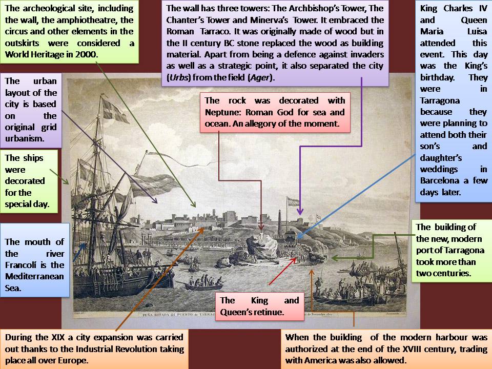
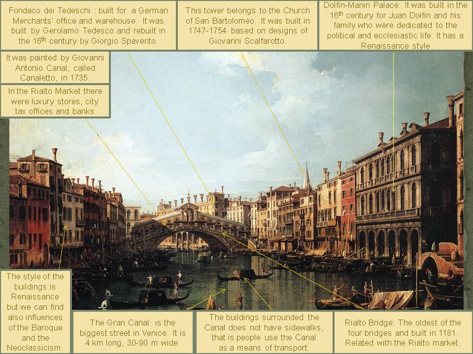
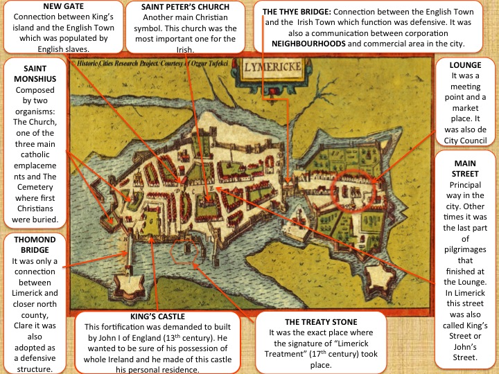
This image is a representation of Limerick in 1617. Its authors were Georg Braun and Franz Hogenberg. The first one was the canon of the cathedral of Colonia and the second one was one of he best engravers in Modern Era. This image is included at Civitates Orbis Terrarum, an atlas composed by six volumes. It was a complementary project for Abraham Saur’s atlas, Theatrum Orbium.

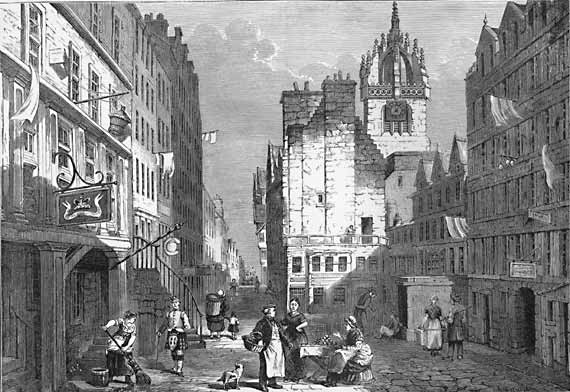
Focused on the image, we can see a medieval city which main characteristic was an irregular town planning, with narrow and non-parallel streets that favoured the appearance of many angles. In the centre we can find the main buildings. In this moment, Limerick showed the urban planning of an organic town. It grew up spontaneously; so if we want to analyse it, we should start from the very beginning: firstly the King’s Island, secondly The English Town, and finally The Irish Town.

According to the structure, King’s Island had a city centre where we can appreciate Saint Monshius Church surrounded by corporation neighbourhoods and by the King’s Castle. At the end of the city there were some abbeys. The city walls protected the whole settlement. The Thomond Bridge linked the King’s Island with the closest county. Because of this I tend to think that the function of this part of the city was for the king to control and to direct. It was also the selected location for high-class people.

Apart from it, The English Town was and added place to the original city and its morphology followed an orthogonal town planning. The main building was Saint Peter’s Church followed by more corporation neighbourhoods and little individual houses. It was also surrounded by city walls. According to the function of this zone, The English Town tried to make Limerick self-sufficient because that was the place where peasants lived and had their crops both for sale and for subsistence. The building of the walls of the English Town on King’s Island commenced in the 13th century and when it was completely finished had a circumference of 1.5 miles.

Lastly, the Irish Town was the third inclusion to Limerick. Its town planning was radio-centric. We can observe the lounge in the centre and the expansion of the town around it. Close to it we can find Our Ladies Church surrounded by many houses with two floors. Here there were also city walls even stronger than in the other parts, because The Irish Town was designed for avoiding enemy attacks. The function of this part of the city was strongly commercial, that is why the houses had two floors and it contributed to create a commercial ambiance. The construction of the Irish Town began in the year 1310 and was completed in 1495. Although different in shape from the English Town, its area had and circumference roughly similar. Both towns were joined by Thye Bridge, which was built at the narrowest point of the Abbey River in 1340.

Although the appearance of the city did not follow a regular model, it had a main street that crossed the whole settlement from East to West. Furthermore it is nice to know that the main street could not have any obstacle, if it happened the building was demolished or the person was expelled. Each area in Limerick was linked by different elements, The New Gate for King’s Island and The English Town connection and the Thye Bridge for joining The English Town with The Irish Town.

Limerick is the third biggest city in Ireland, located on the West of this country. It is the capital of the county of Limerick, in Munster province. The main geographical element is Shannon River, the widest river in Ireland that flows into the North Atlantic Ocean. Curiously this city is the only point where this river is not affected by oceanic movement. We may think this river modified the development of Limerick in ancient times because it limited the expansion of the surface and favoured other kind of external relationships by means of trade seeing that it was close to the ocean and travelling over other countries was easy. That is why Limerick only grew by connections whit other territories through bridges. Following this line, another aspect we have to know is that Limerick had an strongly defensive function represented with city walls all over the town or with the star-formed fortresses. Besides they were decorative instruments.

Regarding History, In 900 A.D Danish Vikings came and settled here. In 1197 the city obtained its Charter of Privileges by Prince John, Lord of Ireland, who became King of England in 1199. King John’s Castle was erected between 1200 and 1207. In 1197 Limerick was also the first city in Ireland to appoint a mayor, Adam Sarvant, and his bailiffs were John Bambery and Walter White.

Limerick has been a site of many major battles. Oliver Cromwell’s son-in-law, Henry Ireton, kept the city under siege in 1651. King William III’s army did the same in 1690 and again in 1691. This same year, on the 3rd of October took place the signature of the ‘Limerick Agreement’. The tradition maintains that it was signed on The Treaty Stone near Thomond Bridge. In 1760, Limerick was proclaimed an open city and the demolition of the medieval walls began. The Great Famine of 1847 did not affect Limerick because of the work of charitable organizations and also because the people were not entirely dependent on potatoes. Some of the industries providing employment in the 19th Century were those of leather, lace, flour milling, bacon, clothing, tobacco, brewing, papermaking and milk processing. During the 20th Century, many of the traditional industries ceased trading. These have been replaced by industrial estates catering for large and small concerns.

In conclusion, Limerick has suffered many changes during History. In 16th century Limerick was an exclusively agrarian society but in the curse of time it turned into an advanced region about technology and economy. At the same time Limerick never forget its trade relationships with external emplacements. In ancient times and nowadays, Limerick keeps their interchanges with other countries, mainly of vegetables and weaves. It is very remarkable the railway connection between Limerick, Dublin, Cork, and Waterford in 19th century. This fact established a new way of trade not only by ocean transportation. It also contributed to expand the influence of Limerick inside Ireland and it was a showcase for inland tourism, becoming one the most important incomes activities.

As I see it, Limerick has always been a city with important internal problems that tried to overcome and take advantage of them. But it also has been a city with a huge personality that has developed a special taste for writing and music, seeing that there were born some celebrities like Oscar Wilde or James Joyce.

Alba Espinar Requena
 

04/10/13

NEW YORK (Stephen Wiltshire, 2008)

This work of art belongs to the collection of Stephen Wiltshire. It represents the most important open air space in New York, Central Park. This painting is from 2008, as the date in the left side points out «14, 11, 08». The painter is a British architectural artist who has been diagnosed with autism. His signature is in the bottom right border. He is known for his ability to draw a landscape from memory after seeing it just once. He founded his own permanent art gallery in London’s Royal Opera Arcade, full of drawings and paintings about detailed city spaces.

The image we are introducing here portrays, with a great amount of details, the appearance that Central Park and its surroundings had in 2008, which is not very different from nowadays. This public space is full of green areas, an endless number of buildings and a bridge in the background. In the painting, we can appreciate part of the urban layout of the city which is orthogonal, inherited from the colonial era; the shape of the park is rectangular, closed in by well-aligned buildings..  The streets leading up to the park are straight and narrow. It was conceived during the mid-19th century as a recreational space for residents who were overworked and living in cramped quarters. The Greensward plan used innovative design approaches, including sunken transverse roads with landscape grading and plantings to avoid the physical and visual disruption of traffic.

New York is composed by five districts which are Manhattan, The Bronx, Brooklyn, Queens and Staten Island. The composition has a fantastic aerial perspective and shows three of those boroughs. The artist allows us to see a spectacular view of Manhattan, Brooklyn and Staten Island in the distance. In the horizon it is also clearly represented one of the most important bridges called «Verrazano-Narrows Bridge» which communicates Brooklyn with Staten Island.

On the right part of the painting, although we can hardly appreciate it, the statue of Liberty is drawn. The strong point of this picture is the Central Park green space, which captures all our attention. We can see the «Metropolitan Museum of Art» on the left part of the park, and in the foreground we can find in blue color the «Jacqueline Kennedy Onassis Reservoir». Despite the lack of chromatic variety (only blue for water and green for trees and grass), it is an amazing picture of the open air space of Manhattan, which looks like a jungle in the middle of skyscrapers.

It is curious to point out that The American Planning Association (APA) has named Central Park one of the 2008 Great Public Spaces in America. This big green place is just as revered today as a peaceful retreat from the day-to-day stresses of urban life, a place where millions of New Yorkers and visitors from around the world come to experience the scenic beauty of one of America’s greatest works of art.

Teresa Sánchez Serrano

04/9/13

NAPLES (Domenico Gargiulo, 1654)

This work of art belongs to a collection of the Foundation “Casa Ducal de Medinaceli”, in Seville. It represents the Market Square or Piazza del Carmine of Naples, around 1654. The painter is Domenico Gargiulo, as his signature in the bottom right border points out: “DG”. Recently it has been exposed to the public in the Thyssen Museum in Madrid, as part of the exhibition entitled “Painted Architectures”. It is a painting of urban perspective, which is characteristic of Italian baroque painting. This type of painting centered its attention on urban life and social activities during the XVII and XVIII centuries.

This image portrays with a great amount of details and chromatic variety, not only the appearance that this central Neapolitan square had, but also the bustling activity that took place there on market days. The space is full of market stalls, merchants, buyers, characters with all sorts of professions, animals, carriages and an endless number of objects that turns it into the centre of everyday life of that age. In the image, we can appreciate part of the urban layout of the city. The shape of the square is rectangular, closed in by well-aligned buildings. The streets leading up to the square are wide and straight, inherited from the regular Greco-Roman plan and urban alterations produced in Naples during the Renaissance and Baroque.

The street that we see in perspective stands out in the background, next to the Santa María del Carmine Church. In addition, the composition is spectacular because of the presence of the volcano Mount Vesuvius on the horizon. Regarding the buildings, the majority had a public space on the ground floor, designated for the tavern or shop, while the residence was situated on the upper floors. In the right margin, we can appreciate the large number of market stalls and counters that stand out. On the other hand, on the upper terraces we can distinguish the clothes hanging out to dry in the sun, making reference to the private activities.   

It is curious to note that this Square was the setting for countless historic significant events for the city of Naples, such as the beheading of King Corradino of Suevia in 1268, or the violent repression that followed the mutiny of Madaniello against the Spaniards in 1648. Regarding the monuments in the scene, the Church of Carmine stands out in the background, the funeral chapel of King Corradino in the left corner, and the central fountain, commissioned by the Count Ognate, Viceroy of Naples, in the year 1653.

Josué Llull Peñalba
Ana Elena Reina