
This work of art belongs to a city atlas called Civitates Orbis Terrarum that was published in the German city of Cologne in 1572. It was engraved by Franz Hogenberg, just before many cities were destroyed by the Thirty Years War, and edited by Georg Braun. It eventually contains 546 prospects, bird-eye views and map views from all over the world with a description in latin. Original books are preserved in the Spanish National Library (Madrid) and in the Historical Library of the University of Salamanca.
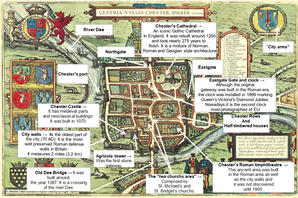
The plan is a bird-eye view of the city, as it would have appeared from the southside. It is headed “Cestria vulgo Chester Angliae civitas” and it is a clear indication of how Chester appeared in the middle of the 16th century because the plan was done in 1571 and it shows a community still living largely within the ancient city walls, with suburban settlements. Chester began when the Romans built a fort called Deva next to the river Dee about 75 AD. At first, the fort was made of wood and in the beginning of the 2nd century parts of the fort were rebuilt in stone. After the Romans left England, around 617 AD a battle was delivered at Chester between the Welsh and the Saxons. The last ones won and gave Chester its name.
The space inside the city walls is full of former houses, fields and gardens and the shape is irregular as a result of the medieval epoque and it causes a disorded growing. As can be seen in the plan, the city is divided into four parts because of two big streets that comes from outside of the city walls. One hand, Eastgate, on the right of the map, and on the other hand, Northgate, at the top of the map. Beyond the Eastgate we can see a secondary defensive gate and wall called The Bars. The four principal gateways as well as The Bars consist in two castellated towers with an archway for the road between them. The most interesting feature in connection with the Walls is the presence on their outer boundary of a deep ditch or fosse, which commences at the Eastgate, and extends from thence along the whole line of the North Wall to the Water Tower, the greater part of which at the present day is represented by the Canal. It is more than probable that this was the old Roman fosse, that originally extended along the entire eastern side of the city to the Dee, thus completing the defences on the land side.
Regarding the buildings we can see a lot of landmarks like the Cathedral, the Castle, the Old Dee Bridge, St. John’s Church, the Market Square and two ancient churches facing each other. These two chuches were St.Michael’s on the right and St. Bridget’s on the left and they were demolished in 1830 and 1964 respectively. All of them are in general sourrounded by trees and well-aligned houses. Also, we can see that the historical buildings are inside the walls and outside the boundary we can see an area of substandard housing and other spontaneous settlements sourrounding bypases.
It is curious to note that in the image we can see a port and that is because for centuries, until the disastrous silting of the river, Chester was the largest and busiest seaport in north west England, trading with ports throughout the British Isles, Ireland and Europe. Another interesting fact about Chester is that the houses that were built in the Medieval ages. They are called half-timbered houses and they are black and white.
Jesica López Corroto