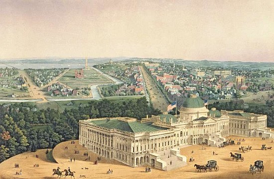
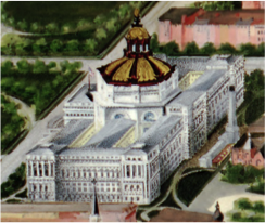
WASHINGTON D.C. (John L. Trout, 1901)
This picture is an areal view of Washington that was painted by John L. Trout in 1901. This piece of art is placed at the Library of Congress in the Geography and Maps Division. The style of the picture is interesting because of the green, red, blue and white tonnes that facilitate the recognition of the main elements of the city. Beside this, it was painted in watercolours and gouache which is a type of opaque watercolour and then it was decorated with a wood frame and golden paper. As it can be seen, this painting portrays the city of Washington during the 20th century with its main elements like the Capitol, The White House, The Washington Monument, and the Library of Congress.
George Washington founded the city of Washington D.C. in 1791 with the idea of a new Capital for the United States, where ancient Greek and Roman democratic ideas were presented. Years later, in 1871, as a result of Washington D.C. growth, the Congress established that George Town was going to be incorporated to Washington City. George Town is placed in the top left of the image and it is possible to appreciate some details of St. John’s Church, designed by Benjamin Henry Latrobe.
Washington City is next to Maryland and Virginia states. This city goes through the Potomac and Anacostia’s river shore, which had an important role in George Washington decision of where to place the city, because these rivers were an ancient way of transport and their shores produced fertile lands. The town planning was designed by Pierre L’Enfant, who had the idea of a grand European style capital. Big avenues crossing important monuments were thought to be the main points of the town planning. However, the cost of this planning was very high and, therefore, the Government decided to stop the works. Before this, the city started to grew uncontrollably until 1901 when the ideas of L’Enfant where took into a count again.
In the picture it can be distinguished a regular and radio centric planning as it can be appreciated in the situation of the main streets across the Capitol. It was a proposal of George Washington, who wanted a classical town planning based on a monumental conception, big avenues, parks and with the main streets going across the most important buildings like the Capitol and the White House. The main streets were thought to improve the access and the movements of pedestrians. Consequently, they were straight, wide and with lots of crossroads. Some examples are: Pennsylvania Avenue, Maryland Avenue, South Capitol Street, New Jersey Avenue, East Capitol Street and North Capitol Street.
Regarding the monuments in the scene we can distinguish the following.
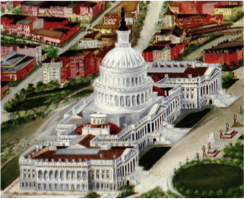 On the right side we can see the Capitol, which is one of the most important buildings of the U.S history. The Capitol was ordered to build by George Washington in 1793 because he wanted that the Congress and Senate were together in one building. In 1800 the Senate wing was finished and fourteen years later, during the Anglo – American War, the British burned the Capitol and other monuments. After this event the Capitol was rebuilt and redesigned by Benjamin Henry Latrobe. Nevertheless, in 1850 it was necessary to enlarge this building due to the increasing number of Congressmen and Federal States. It was completely restored in 1868. The style of the Capitol is Neoclassical as it can be seen in the varied use of columns, arcs, vaults and straight windows. Inside the Capitol there is a fresco entitled The Apotheosis of George Washington that is behind the vault and shows the president´s ascension to the sky.
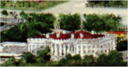 The White house was started to be built in 1792 and in 1800 President John Adams moved there with his wife. Then, in 1814, the British burned it. After this, it was restored in 1817 in the presidency of James Monroe. The White House has been rebuilt many times, starting in 1902 with the presidency of Roosevelt and finishing in 1952 with the presidency of Harry S. Truman. The style of the architecture is the same as the Capitol. Both have a Neoclassical style as it can be seen in their elements. The porticos on the entrance and the background were built during 1824 and 1828, and have four and six columns, respectively.
The Library of Congress was established in 1800 inside the Capitol for the Congressmen but unfortunately the British burned it in 1814 and all the books were lost. Although President Thomas Jefferson was retired, he donated his own personal library to the Congress Library one month later. Seventy-two years later, in 1886, the Congress authorized the construction of a library outside the Capitol with an Italian Renaissance style in the outside. In the inside the architect Edward Pearce Casey, with the support of forty-two sculptors and painters, decorated the library imitating the Paris Opera House, with marble, ionic columns, and sculptures.
To conclude, I want to highlight that during the 20th century Washington City suffered an increase of its population, even when the World War two was taking place. However, when the War finished a big migration from other cities to Washington suburbs took place.
Diego Guzmán Medrano.