
NAPLES (Caspar Van Wittel, 1700-1710)
The painting which is got to be analyzed belongs to the city of Naples. It was made by Gaspar Van Wittle between 1700 and 1710. Van Wittle (1653-1736) was a Dutch painter who was born in the Nederlands but his family settled in Rome and he lived in this city almost all his life. There was a period of his life in which he travelled all around Italy, and it was in this period when he painted the picture that we are analyzing. The image represents the port of Naples and owns to a private collection but it has been recently exposed in an exhibition named Painted Architectures in the Thyssen Museum in Madrid.
The city of Naples is the reference of the region of Campania where the landscape is mixed of history and culture. Naples was founded by the Greeks in the VII century BC and became one of the most important cities of the Magna Greece. It was very important because of its historical progress and the city reaches its peak in 1442 under the Aragon’s domination. It is important to say that Naples is the fourth most important Italian city due to its economic strength that is focused on tourism, trade and agriculture. Despite this, in the era when the picture was done, the economy was based on shipbuilding. Nowadays other sectors with a high importance are manufacturing and food industry too. The city is lying between two notable volcanic regions, the Mount Vesuvius and the Campy Flegrei, so it might be really dangerous if one of them erupts. In spite of this this fact the city was placed in this area due to the soil fertility induced by the volcanos.
This picture shows the city of Naples from the perspective of the port so the core topic of the representation is the activity which takes place there. If you look at the center of the picture you can see how a long and narrow street enters into the city between a number of buildings. Other elements that we can see at first glance are some monuments that were constructed in the medieval era and still stand today. Concerning the structure of the city, it is divided into two differentiated areas. On the one hand we have the Old Town. The spatial distribution of the houses and the streets in this area is irregular, probably because the buildings were placed spontaneously as the inhabitants settled there. On the other hand we have the newest area of the city which has a more regular layout due to a better urban planning.
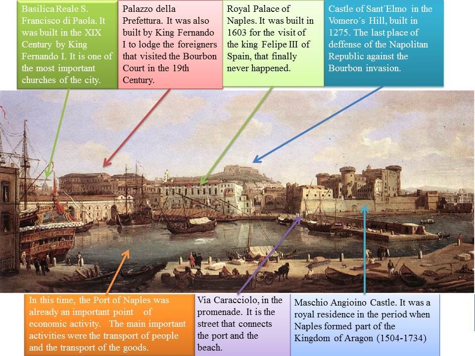
The first building we can see just behind the port is the Castel Nuovo that was finally named as Maschio Angiano. Other significant buildings are the Castel dell’Ovo which is the symbol of the city, the Royal Palace Reale, the Castel Sant´Elmo and the Archeological Museum where there are Greco-Roman testimonies and objects from the excavations of Herculaneum and Pompeii. If we walk along the first street situated in front of the Castel Nuovo, that is named via Toledo, we arrive to the historical center of the city. This part of city has a Greco-Roman urban layout divided in three long streets named decumani that are cut at right angles with other streets named cardini. In the main crossing it is situated the Piazza del Mercato that can be considered as a Central Business District because in there all the activities of the city take place both in the past and nowadays.
It is important to note that in the city underground there are many caverns and galleries that were excavated by the Greeks to extract building materials. Now these galleries can be visited in excursions organized by the Archeological Museum. One important factor in the city is the role of religion so a lot of churches were built from the Medieval Era such as Santa Maria and the basilica of San Francisco de Paula which was created by the Bourbon king Ferdinand I. This king also ordered to build the Palazzo della Prefettura which was the place to lodge the foreigners who visited the Bourbon court.
Ana Isabel Morilla Leiva
Fernando García Moreno