
This is a map that represents Heidelberg, an university town in Baden-Wüttemberg situated on the river Neckar, in south-west of Germany. The map represents the city in 1931 and was made by John Bartholomew & Son, a map publishing company originally based in Edinburgh, Scotland and specialized in the use of hypsometric colouring in relief maps. The company was established in 1826 by John Bartholomew. This image I took it from Alamy’s library.
We can appreciate that the map represents the urban layout of Heidelberg and it allows us to identify the main elements of the city, such as the Castle, the University, the Market Square, the Neckar river, etc. Also this map allows us to see the relief and the most important mountains that surround Heidelberg.
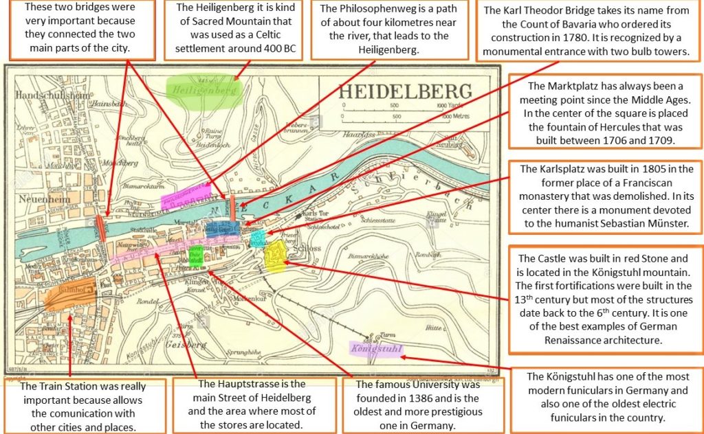
The city is located is in the Rhine Rift Valley, on the left bank of the lower part of the Neckar in a step valley in the Odenwald. It is bordered by the Königsstuhl (568 meters) and the Gaisberg (375 meters) mountains. On the right bank of the river, the Heiligenberg mountain rises to a height of 445 meters. Because of its relief and that is in a valley is one of the warmest regions of Germany and plants atypical of the central-European climate flourish there, including almond and fig trees. Heidelberg has an oceanic climate, defined by the protected valley between the Pfälzerwald and the Odenwald. Year-round, the mild temperatures are determined by maritime air masses coming from the west and its position in the valley leads to more frequent easterly winds than average. The hillsides of the Odenwald favor clouding and precipitation. The warmest month is July and the coldest January. The geographical situation in which it is located, the good temperatures during summer and spring and the abundant rainfall provide a rich environment for flora and fauna. As well as being in a valley and near a river and good temperatures makes the population to be abundant, but being surrounded by mountains does not allow an excessive growth of the city.
About the urban planification and structure we can apreciate that the shape of the town is linear and it grows along the river. The oldest buildings as the University, the Jesuit Church, the Market square and the Holy Spirit Church are in the historical center of the city. The only important buildings that are moved away are the castle or Schloss and the train station. In the plan we can observe that in the University area we have there is a regular expansion similar to an «ensanche». On the other hand, near the Castle the urban layout is irregular and is probably one of the oldest parts in the city. All the streets around the train station present an irregular plan with very narrow streets. This probably corresponds to the working class neighborhood that were near the station to have a job closer. More beyond we can see a natural boundary that is the river. It divides the city and can be crossed only by two bridges. Behind this part we can see two neighborhoods; one called Neuenheim and the other one called Handschuhsheim. The first one presents a regular plan with wide streets so it will be probably a second “ensanche” created for rich people that looks for a relaxing place to live. The Handschuhsheim neighborhood could be considered to be at the perifery of the city and it presents an irregular layout with narrow streets.
Heidelberg is a city founded on the ruins of ancient Celtic populations, which in the 9th century were already outside that area of Germany. In the year 863 the monastery of San Miguel was founded within the walled Celtic fortress that today corresponds to the city center. From here, Heidelberg begins to gain in importance. The splendor of the city comes when the Hohoenstaufen family took care of the castle.
But the most important fact that made Heidelberg famous was the construction in 1386 of the university. It was founded by Ruperto I that was the Elector of the Palatinate, and is the oldest and one of the most reputable universities of Germany. The role of the university in the Humanism and in the Lutheran and Calvinist reforms meant that Heidelberg became a very important center of knowledge and culture. During the Middle Ages and the seventeenth and eighteenth centuries, Heidelberg remained a very important city within Germany, hosting various meetings or peace signatures, such as the Holy Alliance in the year 1815. Nowadays Heidelberg is famous and important because it University and the rich of his historic center.
With all this information we can conclude that Heidelberg is a city with many differences comparing to the rest of Germany because it has a different climate and warmer thanks to be in the valley of the river Neckar and surrounded by mountains. In addition, it has a huge importance since it was a cultural and university city that turned it into a tourist attraction nowadays. Its main activities over the centuries are arts and literature and this is why it was designated as the «City of Literature» by the UNESCO Creative Cities Network.
Marta Couso Rodríguez