
This image represents the city of Santiago de Compostela in 1900. Its author is the geographer Anstalt Von Wagner, and the picture was published in Leipzig, a German city. Santiago de Compostela is located in the northwest of Spain, in the region of Galicia. It takes place between Pontevedra and La Coruña provinces, and belongs to the last one. In 1985, Santiago was proclaimed a World Heritage Site by the UNESCO because of the exceptional beauty of its old quarter. Moreover, this city is important because The Way of St. James which is a pilgrimage road departing from different places to arrive in the city with the aim of adoring the grave of James Apostle.
The origin of this city goes back to the 6th century, when it was a roman villa. Before that, it was built a mausoleum where it is supposed that the death body of James Apostle was buried. In the 9th century, King Alfonso II announced James Apostle as the patron saint of the kingdom, so the city was transformed in a devotion place. He ordered to build a chapel, which was placed next to the mausoleum, but some time later it was destroyed, so in 1075 the current Cathedral or Santiago was constructed. In later centuries, there were added some Gothic, Renaissance and Baroque elements, according to the artistic periods. In addition, in the 14th century the Cathedral acquired defensive elements, like The Clock Tower. In the period of the Renaissance, the final cloister was built. However, in the Baroque age, the High Altar experienced great transformations, and in 1750 the most important element of the cathedral, the facade of the Obradoiro, was finished. Nowadays, Santiago de Compostela is known as one of the most important cities of Spain in regards to its heritage.
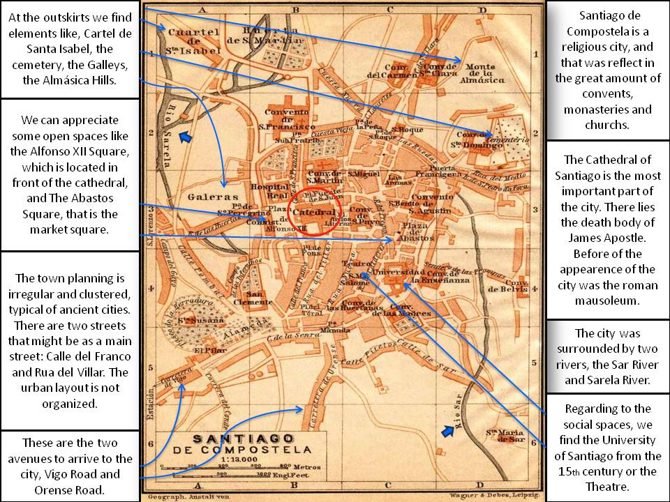
In the image, we can appreciate the urban planning of the city, which is very irregular and clustered, typical of medieval cities. The most important element in the map is the cathedral, which is located in the centre of the old quarter. Around it, we can see some important buildings like The San Paio Convent, The San Martin Convent and The Hospital, which nowadays is a guesthouse. As you can see, the majority of the buildings are religious; there are a lot of convents and that is because of the story of the city. Moreover, we can appreciate some open spaces like the Alfonso XII Square, which is located in front of the cathedral, and the market square, which is called The Abastos Square. In the picture there are two avenues which are the principal routes to arrive in the city; at the south there is the one called Orense Road, and at the southwest is located the other one, which is called Vigo Road. Regarding the social spaces, we can find the University of Santiago from the 15th century, and the Theatre. Also, in the 19th century the city wall disappeared so it is not in the image. In addition, there are some elements in the outskirts such as the Cuartel de Santa Isabel, the cemetery, the Galleys and Almásica Hills. Finally, the city was surrounded by two rivers, the Sar River from the north to the southwest and Sarela River, from the north to the south.
Concerning to the economy of Galicia at the end of the 19th century, it was very traditional because agricultural activities were highly predominant. This activity was the most significant and it was determined by a property regime based on a foral system. The land was divided in smallholdings of corn and rye as well as little farms used for self-supply that owned to some farmers and the clergy. The benefits were destined to the foral rent, the tithe, the feudal rent, and the rest was used to survive. However, the rent was not enough to survive, and the farmers had to practice supplementary activities as fish salting, tanning, iron working or even seasonal emigration. But some part of the lands was out of the foral system, and fundamentally they were pastures and marginal soils. Regarding to the industry, it was practiced in the seasons in where the agriculture was lower, normally at winter, and the products arrived to the peninsular market by the seasonal emigrants.
Comparing with the primary activities, the city just constituted a small part, and it was principally a residence for the landlords, the clergy and workers. There were just a few activities which conferred importance, like the modification of the A Coruña port as a headquarter of the sea mail between the peninsula and the American colonies or the creation of a tobacco factory. At the beginning of the 20th century, Galicia was characterized by a high concentration of the economic power in small sectors, a feudal system and an increasing emigration.
Natalia Pinet