
The picture depicts the city centre of Danzig (Gdansk in Polish), West Prussia, Germany (now Poland). The picture is part of the collection of the Library of Congress, Prints and Photographs Division on Washington, D.C., and was made in the late 19th century. It is a color photochrom print, a style which was common on Europe, Middle East and North America and was published from 1890s to 1910s, created by the Photoglob Company in Zürich, Switzerland and the Detroit Publishing Company.
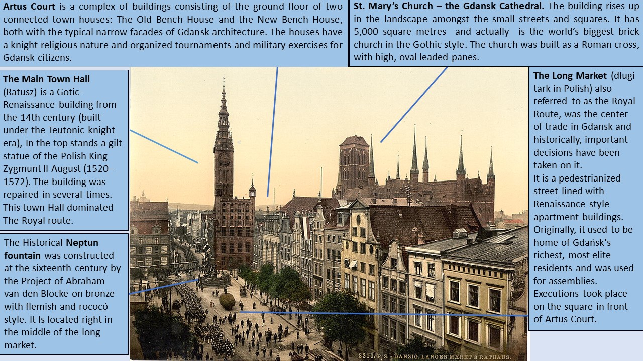
The image shows the Long Market, a square surrounded by buildings and its environment. It is possible to appreciate that the space around the main square is full of people making trades and spending their leisure time on market areas. It shows also the vegetation, ornamental plants and the beautiful monuments used to magnify the view, such as the Court House. The shape of the space is linear and open, so that the street connects the end of Long Lane and Green Gate to the channel port.
The original city plan was irregular, typical in the medieval European center cities. The city was built around the commercial port, once settled in the first growths along the river, spread following a rectangular plot generating an old cultural center. This is an area where there are mannor houses and important infrastructures, that are the symbols of the city. The market street, as it was renewed in Modern Times, is the main axis of the residential and port area. From this new residential focus came new expansions that were planned radially and delivered various stages of expansion.
Regarding the city itself, Gdansk (Danzig) is a large harbour city located on the Baltic Sea coast, founded around one thousand years ago. It is renowned for its beauty and dramatic history. For over seven centuries it was under the rule of Poland, but enjoyed considerable autonomy, and attracted many German, Dutch, French, Scottish, and other immigrants who became merchants, artisans and workers, and remained faithful to Poland in tough times. The origin of the city dates to Mieszko I who founded the town in 980s, by the Piast Dinasty setting the trade routes of the Baltic Sea.
The city became a full member of the Hanseatic League (it was a commercial confederation of merchant and market towns) and raised as a maritime force and a center of commerce under the Teutonic knight’s dominancy (1308–1454). The new rulers attracted settlers from Germany and the town enjoyed a period of economic and cultural prosperity. Gdansk had the main export port and it was a commercial center of wheat and timber. Historically, the main economic activities of Danzig were fishing, amber processing, metal extraction and crafts such as metalworking or shoemaking.
Throughout history, Poland has suffered a lot of divisions with the neighbouring countries which caused migrations and demographic changes. During the second partition of Poland in 1793, the resistance of Gdansk’s citizens delayed the capture of the city by the Prussians. The politic context in which the picture was taken dates back some decades after Napoleon declared Gdansk to be a Free City in 1807; because after his downfall, the city was annexed again to Prussia (Germany, after its unification in 1871).
It is also important to know about the Polish corridor (Gdansk corridor). This zone comprised the north of the country, what is known as Pomerania. Historically it has been a very quoted area because the opening to the sea. At the root of the Treaty of Versailles (1919) the area returned to Polish dominion after a long time. One of the reasons for the beginning of the Second World War by Germany was the consequent strategic loss of this territory and the part of connection of the Baltic Sea. It was in Westerplatte (a peninsula in Gdańsk harbor channel) where the Second World War actually began.
Roberto Maderuelo Karwowski