
PALMA DE MALLORCA (Antonio Garau, 17th century)
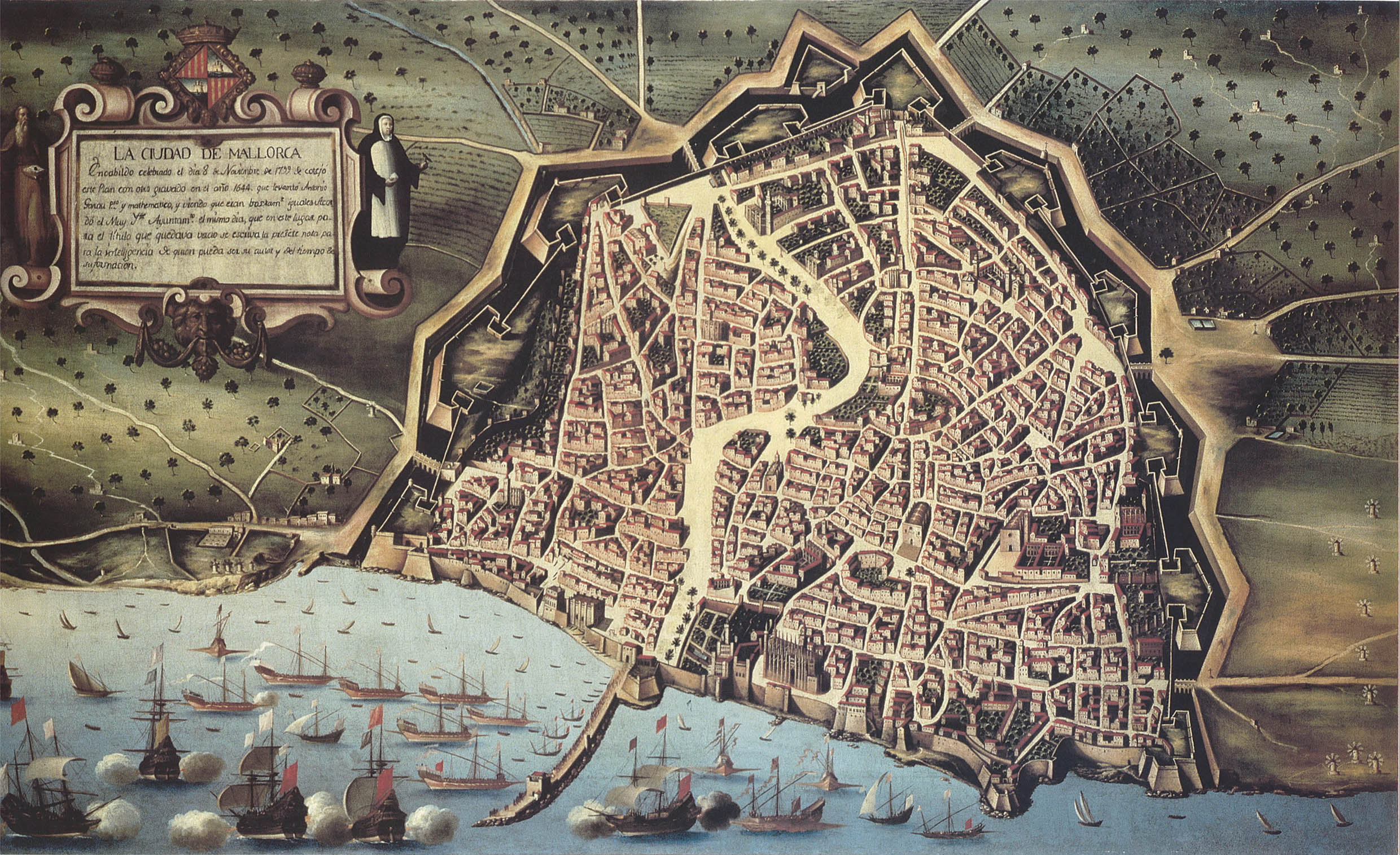
This work of art is an anonymous oil painting displaying the city of Palma de Mallorca in the 17th century. It was 300 years in a room next to the Plenary Hall of the Town hall of Palma and a few years ago it was transferred to the museum of Bellver. It is an oil painting on canvas by author and unknown date. According to some research, still unfinished, possibly the date of oil painting is between 1647 and 1650 and perhaps this was painted by Marc Corró. In the oil painting two characters are represented; the first one is Ramón Llull, Mallorcan who lived between 1232 and 1316, and was a versatile writer who expressed in Latin, Catalan and Arabic, and the other personage is Catalina Thomas, a nun born in Mallorca and Saint of the Catholic Church. Also appears the shield of Mallorca and a text that says: “In the Balearic government celebrated the 8 of November of 1799 this oil painting was compared with another engraving in the year 1644, that realized Antonio Garau, mathematician and seeing that they were quite equal agreed the City Hall this note to know who can be its author”.
In 1997, the city council of Mallorca thought it was appropriate to investigate the data in the table. Twelve years earlier, it had been restored and compared by reducing the scale of the oil painting and overlapping it in such a way that the enclosure of the city wall fits with the map of Palma de Mallorca made by Antonio Garau in 1644 who was a presbyter, mathematician, teacher and canon of the Cathedral, and died in Palma in 1657. This map represents very in detail the walled city, together the shield of Palma and a list with the 46 most important buildings and places. The conclusion was that Garau’s map was used to make this oil painting, or the other way around, that this oil painting was used to draw Garau’s map.
The city of Palma is located in the center of the bay of Palma. The island of Mallorca lies in the middle of the western Mediterranean off the coasts of the Iberian Peninsula. The picture shows that the main economic activities are agriculture, due to the large extensions of cropfields, and trade because of its strategic location in the Mediterranean Sea. Another notable area is the military activity, whose mission was to defend the city from outside attacks.
As we can appreciate, the only water stream that appears in the oil painting is the Riera. This sort of river passes now through the Ramblas, Union Street and Paseo del Borne, but in the 17 th century was diverted so that it did not cross the old town. In the image, we can appreciate the different areas such as the center of the city that has a radial distribution around a central square where the streets meet. The southeast zone has a more regular layout because the streets have right angles. The rest of the areas have an irregular, chaotic morphology, because the streets do not follow a previous order and they appear disorderly, being frequently narrow, sinuous and twisted, with dead ends and closed alleys. We also observe in the map that the irregular plan predominates respect to the others, although there some axis delivered in a radial way.
In addition, the picture shows that the city is separated by a long road that leads to the port from north to south. It was in the port area where the most populated places were situated, thanks to commercial activities. The city is also surrounded by a city wall that was designed in the form of triangles where the cannons were placed so much to attack as to defend against the artillery. The city wall separates Palma de Mallorca from the sea and continues closing the perimeter of the city, whose purpose was to protect its inhabitants and defend it from external aggressions.
The rest of the land outside the city was dedicated to the forestry and agricultural sector, which was divided into open field (large tracts and was managed by the upper class) and enclosed field (small plots that worked the poorest classes). Also, in the outskirts we can observe plots, extensions of land, mills, etc. The main crops were olive, vine and cereals, while in the livestock sector sheep herds stand out. In the foreground, you can see the Mediterranean Sea with many boats around the city. During the 16 th and 17 th centuries, agriculture was the economic and productive base of Mallorca, because its economy was based on a system of autarchy that concentrated a large part of the population employed. To summarize, the primary sector (agriculture, livestock, commerce and fishing) was highly predominant.
It is curious to note that the city of Palma was originally occupied by a Talayotic settlement. Later in 123 a.C. it was invaded by the Roman consul Quintus Caecilius Metellus. The remnants of walls and important buildings (an amphitheater, for example), affirm that the Roman Palm was in the high part, around the place of Cort. Subsequently, the island of Mallorca was occupied by Vandals and Byzantines. Later, in 903, the city was conquered by the Arab general Isam al-Jawlani; from that time we conserve the Royal Palace of the Almudaina, the Arab baths and the Arab city buried under the present city. The first certified name of the city is the «Madina Mayurqa» of the Arabs. An historical event that took place in 1229 was the conquest of the city by King James I of Aragon, who namet it Ciutat de Mallorca. This is the name the city would have until the Spanish Succession War. As a remarkable fact, Mallorca was the last territory to surrender before the army of Philip V of Borbon, on July 3, 1715. We must mention that one of the acts approved by Philip V was to change the name to the capital «Ciutat de Mallorca» for «Palm».
Concerning its economic activities, the geographical location of Mallorca allowed an intense commerce with the towns of the Maghreb, Italy and Turkey. In the Lonja was an active market supervised by the Consulate of the Sea. Nevertheless, at the beginning of the 16th century, the plague, rebellions and attacks of Turkish pirates led to a reduction of commercial activities and the city entered into a period of decline that lasted until the end of the 17 th century. Most of the medieval guilds, such as fishermen, silversmiths, surgeons, tailors, butlers, blacksmiths, etc., were located between the old town and the port area. The rest of the occupations, such as millers and farmers, was located in the periphery. As for religion, in the 17th century Catholicism predominated throughout the island and other religions were discriminated and marginalized.
To finish with, we can mention the most prominent places to be appreciated in the map. In the foreground is possible to see some monument as Santa Maria Cathedral, La Lonja, El Consulado del Mar and La Almudaina. On the right side, we can distinguish the Arab baths and the towers of Gumara, another important monument that does not appear is the Bellver Castle and the cathedral is the most outstanding monument of oil painting.
Alexandra Villegas Almazán