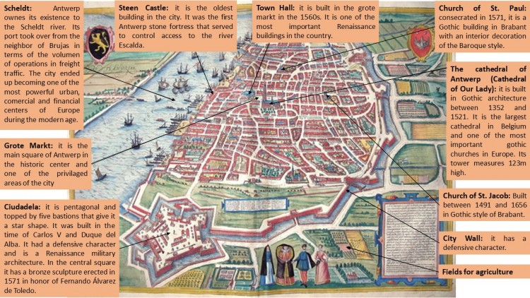
ANTWERP (Georg Braun & Franz Hogenberg, 1572)
In the 14th century, Antwerp became the most important commercial and financial center in Western Europe. Its reputation was based mainly on its port and its wool market. Its splendor was also due to its system of fortifications that aimed at protecting the population. Initially, the city was annexed to the county of Flanders, which made Antwerp lose great importance, but fifty years later Antwerp went into its Golden Age and became an international metropolis described as «the most beautiful city in the world». From the 15th century onwards, it began an economic development of the city becoming one of the most important commercial centers in Europe. In the second half of the 16th century, the city was the center of the political-religious struggles between the Protestants of the north and the Catholics of the south controlled by Spain. That situation led to the closure of the Scheldt and supposed an economic disaster, so it was easy for Spain to conquer the city.
The economy of Antwerp was very good due to its large port with its strategic location in northern Europe and the surrounding Scheldt River, which also served as protection. It was a platform for addressing merchandise both export and import for Belgium and other countries. Antwerp was known for its exports of textiles, paintings and prints for Europe, particularly for Spain and America.
The fortified structure of the city is observed with great clarity, surrounded by a channel that served as defense. The urban layout is mostly irregular. In the west side we can find the river Scheldt and the port, which was essential for Antwerp as it became one of the most important cities in Europe in terms of commercial aspect. Next to the river is located Steen Castle, an old medieval fortress to control the access to the Scheldt. A few streets on the right is the Grote markt square, which is the main square of Antwerp and where the town hall is located. This building was included in the list of World Heritage Sites by the Unesco in 1999. Next to the Grote Markt, are located other relevant constructions of the city, such as the Cathedral of Our Lady, which is the largest in Belgium and one of the most important in Europe, as well as an Unesco World Heritage Site. The rest of the city was composed of different houses and churches, such as the church of St. Jacob and St. Paul, which was linked through multiple streets, usually short and irregular.
Gothic is the most popular architectural style of the city, as we can see in the Cathedral of Our Lady, built between 1352-1521 and considered one of the most important Gothic cathedrals in Europe. Also in the church of St. Jacob, built between 1491-1656, and in the church of St. Paul, built in 1571 on the outside, although its interior was Baroque.
Ángela Ladrón de Guevara Hernández

