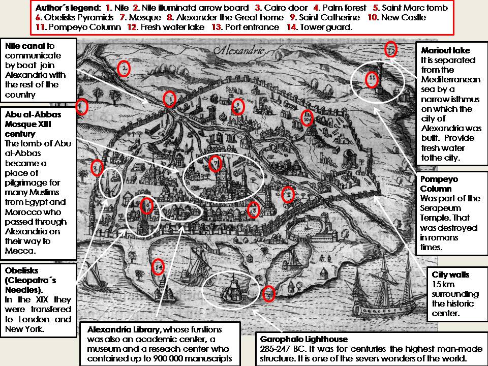
This engraving is part of the book Relation journaliere du voyage du Levant, a collection of 47 drawings and maps, written in 1615 by Henry de Beauvau, a soldier and traveller in the Middle East. The image is adapted from the original published by Georg Braun and Franz Hogenberg in the first volume of Civitates Orbis Terrarum, an atlas of cities of the world that was published in Cologne in 1572. It represents the city of Alexandria, which is the second largest urban area in Egypt after Cairo.
Alexandria is located in the north of the country, in a peninsula of the Nile delta. The site was chosen by Alexander the Great in 331 BC because it was considered a safe natural harbour for his fleet, in addition to the healthy climate, abundant fresh water and limestone quarries nearby to supply its future constructions. Alexander was also responsible for organising the urban planning, that followed an orthogonal distribution with parallel and perpendicular streets. However this urban layout was destroyed during the Middle Ages because its inner development turned into irregular. Nowadays, only two parallel streets in the interior still remain from the original structure.
The city was surrounded by a wall of 15 km. Outside this city wall, it is possible to appreciate the outskirts and the cropfields. Also, a channel was built to communicate Alexandria with other cities and another ports located in the mouths of the Nile Delta. We can also see some monuments such as the Pompeyo Column, the Garophalo Lighthouse, the seaports and several orchards. Alexandria was a city with many characteristics of Greek and Roman architecture and urbanism; it had numerous temples, palaces, theatres, baths, gardens, etc. The lighthouse of Alexandria is recognized as one of the seven wonders of the world. It has a height of 134 m and was for centuries the tallest man-made building in the world. After suffering two earthquakes in 1303 and 1323, it was destroyed. The city also housed the most important library in history. It was simultaneously a museum, a school and a centre for educational research. It held the largest number of existing Greek texts in the classical world. Unfortunately, this library suffered a fire in the fourth century. There is now a new Library Alexandrina on the same site, which opened in 2003.
The geographical location of Alexandria between the Nile river and the Mediterranean sea allowed it to become the most important city of the ancient world. Modern archaeological digs have found remains of goods from around the world, from Chinese ceramics to Moroccan dyes. Regarding the local industry, there was a high production of silk, embroidery, cotton and wool. Warehouses were built to store and distribute spices. Thus, the role of the harbour was fundamental for the Egyptian economic development. Besides, the cropfields located on the shores of Lake Mareotis produced wheat, grapes and olives. These products not only supplied the city but were also exported. An interesting example is the Alexandrian wine found in some amphorae in Marseilles.
Since ancient times there have been two ports in Alexandria. The western port was used by fishing boats. An interesting point about this port is that it holds 80% of all foreign maritime traffic in Egypt. In addition, it can accommodate up to 250 large ships in the terminal of the Suez-Cairo pipeline located in Alexandria. Also, there is an oil refinery, a mall and many stores, making it the best port in the eastern Mediterranean. In comparison, the eastern port is less important and is used as a marina.
Today Alexandria is a modern city with a quadrangular urban structure. It is an important cotton textile trade centre in addition to chemical, mechanical, shipbuilding and banking industries. Almost all of the ancient monuments and works of art that speak about the history of Alexandria are scattered around the world. Unfortunately, most were stolen. In present Alexandria city we can only find a few remains of what was once an imperial city. Archaeological work continues to rediscover the past of the city, much of which is under water.
María del Mar Díaz López


All the data are very marked in a structured and clear way. In addition, it is a very interesting and beautiful city with a great evolution.