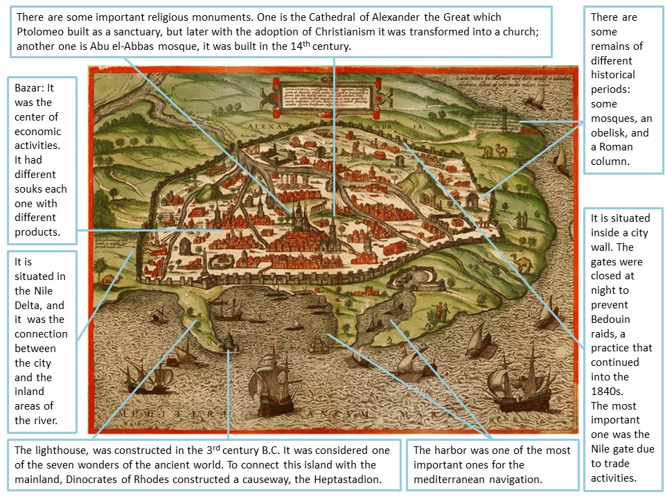
This representation of Alexandria belongs to the first Latin edition, volume II, of the book Civitates Orbis Terrarum which was published in 1575. Its principal authors were the editor Georg Braun and the important engraver and publisher Franz Hogenberg. This book is very important because it was the second oldest printed atlas in the history of world cartography, and the first atlas of towns. The image that I am going to describe shows a bird eye’s view of Alexandria, a very important city in the north of Egypt. It also displays the urban structure and the economic activities of the city in the 16th century.
Alexandria was founded in 331 BC by Alexander the Great in the Nile Delta, and the close proximity of Rhakotis meant access to labor and other services for the creation of this city. The great location was taken advantage of the crops, due to the fertile soil, the trade with other countries because of the harbor, etc.
In the image, we can appreciate the urban layout of the city. This city was surrounded by a city wall, which had an irregular shape, and it protected the city of external attacks; until the 19th century the gates were close because of Bedouin raids. It had four gates, the most important one was the Nile gate due to the trade, however, in the 16th century, it was obstructed by sediments, and the products that arrived through this gate were transported by camels. The town planning was irregular, and the branches of the Nile also set where the buildings were situated; moreover, we can observe that the streets were very narrow. Though in the image we can observe that was a very irregular plan, the ancient town, according to Alexandre’s foundation, had a grid plan with two main streets. But the story of Alexandrian Urbanism has been modified by the political empires, Egyptians, Romans, the Islamic period…, so this is why in the 16th century the city was so different.
Regarding the buildings, the majority were religious spaces. We can observe in the representation mosques, Egyptian monuments, Roman buildings… This variety of buildings is because of the different cultures that have lived there. Concerning the Arabic buildings, the Abu el-Abbas mosque, where the tomb of Abu el- Abbas was located, constructed in the 14th century, was the most important one; it was rebuilt in 1477 under the order of the Mamluk governor Gaqmas el-Zahry. We can distinguish also some Roman buildings, such us the Cathedral of Alexander the Great, Saint Catherine which was constructed during the Roman period, in 527, and the Pompey’s Column. But in spite of all these monuments, the most important was the lighthouse of Alexandria, built up during the Ptolemaic Dynasty era. Located on the eastern end of the island where the Qaytbay Fort stands today, it was considered one of the seven wonders of the ancient world. But it was destroyed in a 13th century by an earthquake.
The image also shows us the economic activities. Due to the great location of the city, its principal economic activity was the harbour trade. Although the Ancient harbour was not used in the 16th century because traders started to use another seaport, this one was kept busy; it received products from the inland areas of the Nile river, Greece, and other European countries. Nevertheless, not only the harbour was the principal activity; after the Ottomans arrival the bazar became into one of the main economic sources. It was divided into different souks in which people could buy a lot of products like special clothes for the desert. Finally, it is curious to note that nowadays the harbour is the most important one of the country, so it keeps some of the importance that it had years ago.
Ainoa Palomo Martinez

