AACHEN (Braun & Hogenberg, 1572)
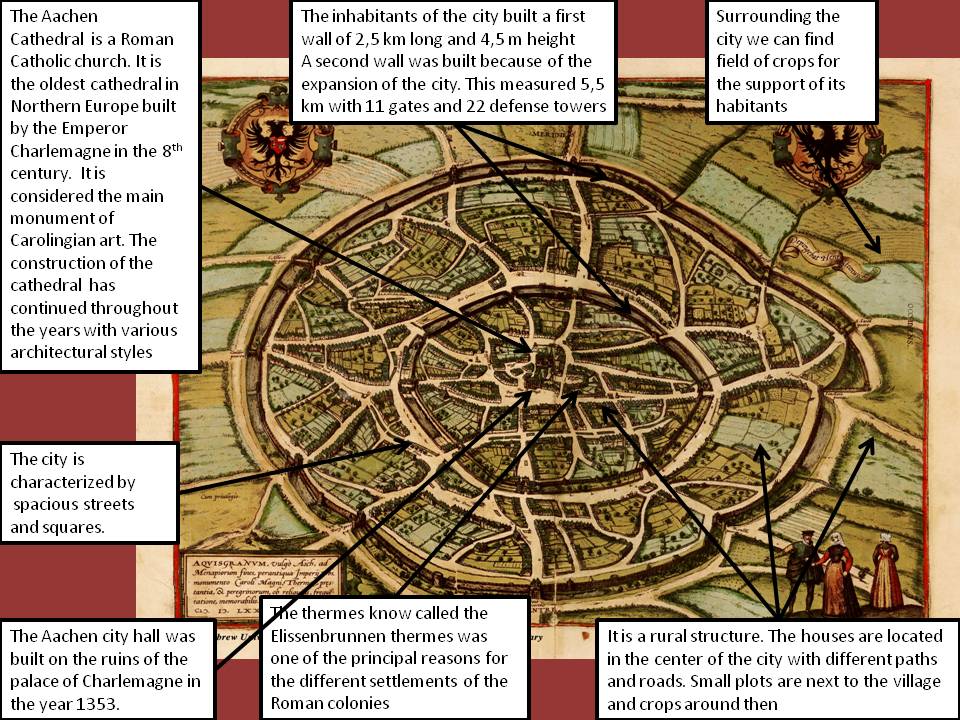
This image is an impressive bird’s eye engraving view of one of the most important urban centers of Germany. It was made in the 16th century, more exactly in the in the year 1572, by the geographers Georg Braun and Frans Hogenberg and published in the atlas Civitates Orbis Terrarum. This book is one of the most important works from the early days of modern cartography and topographical illustration. This impressive production, issued in six volumes from 1572 to 1617, was the first modern atlas and collects more than 500 engravings and descriptions of European cities that allow us to know how they were in the 16th and 17th century.
The imperial city of Aachen lies between the Rhine and the Meuse on the border of the Duchy of Jülich and it has become very famous because there took place important coronations of emperors of the Holy Roman Empire; it was also famous because it was the burial place of Charlemagne. The city of Aachen was a Celtic settlement until the Roman conquest. The Romans used it as a place to retreat and heal the legionaries, probably because of the good location of the city and they took advantage of its hot springs. The Romans name this city Aquisgran after the god granum which was credited of healing qualities. Later on Charlemagne installed here his government office. He constructed a palace (where the present city hall is located) and the Palatine Chapel (the current cathedral). From those places, the city grew in the following centuries giving us the complex conglomeration of different architectural styles that we see now a day.
Regarding the morphology of the city we can see that it presents a radio-centric plane. The radio-centric shape is formed around the catedral, the former Charlemagne’s Palatine Chapel. The city is characterized by ring roads avenues and streets. The streets converge into the center in a radial or radio-centric way. The downtown area is divided into rings and also presents a rural atmosphere because it includes many elements from the countryside. The houses are located in the center of the city with different paths and streets forming a network; small plots are next to the village and crop fields around then. As the majority of medieval cities they built a city wall around Aquisgran. The expansion of the city would continue and would require a more extensive second wall.
The city of Aquisgran was also characterized by the spacious streets and squares. It was surrounded by cultivated land which was use for its own supplies and for external trade of the city. Unfortunately this city was badly damaged during the World War Two because it was attacked by land and air by the U.S. army. It was the first German city to be conquered by the army. There are still few structures of that time but nowdays it looks more like a modern city.
Paloma Bueno

