04/18/18

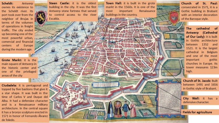
ANTWERP (Georg Braun & Franz Hogenberg, 1572)

Antwerp-Individual work

This picture was created by Georg Braun and Franz Hogenberg, two German cartographers. It was published in the end of 16th century, in 1572 approximately, and belongs to an atlas created by Braun along with several collaborators. This atlas was entitled Civitates Orbis Terrarum and is one of the most complete collection of panoramic views, plans and textual commentaries of cities in Early Modern Times. The image to be commented in this post is a map of the preindustrial city of Antwerp, one of the most important market towns in Belgium along with Brugge.

In the 14th century, Antwerp became the most important commercial and financial center in Western Europe. Its reputation was based mainly on its port and its wool market. Its splendor was also due to its system of fortifications that aimed at protecting the population. Initially, the city was annexed to the county of Flanders, which made Antwerp lose great importance, but fifty years later Antwerp went into its Golden Age and became an international metropolis described as «the most beautiful city in the world». From the 15th century onwards, it began an economic development of the city becoming one of the most important commercial centers in Europe. In the second half of the 16th century, the city was the center of the political-religious struggles between the Protestants of the north and the Catholics of the south controlled by Spain. That situation led to the closure of the Scheldt and supposed an economic disaster,  so it was easy for Spain to conquer the city.

The economy of Antwerp was very good due to its large port with its strategic location in northern Europe and the surrounding Scheldt River, which also served as protection. It was a platform for addressing merchandise both export and import for Belgium and other countries. Antwerp was known for its exports of textiles, paintings and prints for Europe, particularly for Spain and America.

The fortified structure of the city is observed with great clarity, surrounded by a channel that served as defense. The urban layout is mostly irregular. In the west side we can find the river Scheldt and the port, which was essential for Antwerp as it became one of the most important cities in Europe in terms of commercial aspect. Next to the river is located Steen Castle, an old medieval fortress to control the access to the Scheldt. A few streets on the right is the Grote markt square, which is the main square of Antwerp and where the town hall is located. This building was included in the list of World Heritage Sites by the Unesco in 1999. Next to the Grote Markt, are located other relevant constructions of the city, such as the Cathedral of Our Lady, which is the largest in Belgium and one of the most important in Europe, as well as an Unesco World Heritage Site. The rest of the city was composed of different houses and churches, such as the church of St. Jacob and St. Paul, which was linked through multiple streets, usually short and irregular. 

Gothic is the most popular architectural style of the city, as we can see in the Cathedral of Our Lady, built between 1352-1521 and considered one of the most important Gothic cathedrals in Europe. Also in the church of St. Jacob, built between 1491-1656, and in the church of St. Paul, built in 1571 on the outside, although its interior was Baroque.

Ángela Ladrón de Guevara Hernández
04/19/13

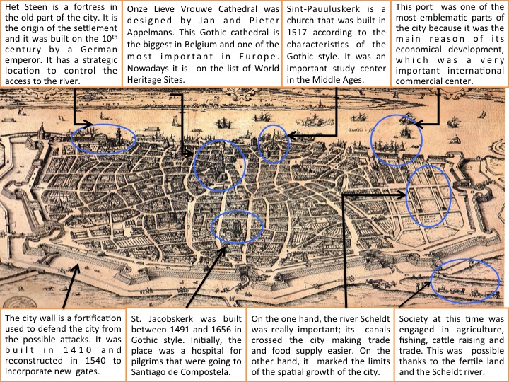
ANTWERP (H. Cock, 1557)

This work of art belongs to a collection of Stedelijk Prentenkabinet. It represents theurban planning of Antwerp and it surroundings. The painter is H. Cock (1518-1570), as his signature in the bottom right margin points out: “H. Cock”. He was born in Antwerp, the city where he founded his own publishing house. He also included the exact year when he elaborated the painting (1557). It is exposed in the Plantin-Moretus Museum in Antwerp, as part of an exhibition of old engravings and drawings. The core of the collection of the print is aimed at Antwerp artists from the sixteenth to the eighteenth century.

The city of Antwerp is located in the North of Belgium. The legend says that the city is named after the expression “hand werpen”; this expression comes from a story of a knight called Bravo, who after killing Antigone, he threw his hand to the river. However, the truth is that this name is a deformation of the word “aanwerp” that means piece of land that was thrown or sharp arrow that points to the Scheldt River.

This city became eventually a wonderful place as a dock. Due to the fact that Antwerp is located in the estuary sealable of the Scheldt River at about 80 kilometers of the open sea, it has a wide range of communication possibilities and its geographical position makes it ideal for trading. The area near the Steen constitutes the old part of the city. The city started to have an abrupt growth around the dock and since then it has continued to expand.However, Antwerp had a limited growth due to the river and the city wall. The urban planning of the city is a mixturebetween irregular and radial because they did not think about the best suitable disposition of the buildings. This is a good example of how cities are considered living organisms. As a consequence of the unplanned distribution and thoughtless growth Antwerp has this irregular blueprint.

In the engraving we can also appreciate some of the most important buildings in that era such as Het Steen, Onze Lieve Vrouwe, Sint-Jacobskerk or Sint-Pauluskerk. The first one is Het Steen, which is the origin of the settlement. It is a fortress built by a German emperor in the 10th century. Later on, a Flemish Duke conquered this fortification and improved the conditions for the economic development of the city. The Gothic cathedral of Antwerp is located in the center of the old town and was built in 1352 by Jan and Pieter Appelmans. It became the most emblematic religious building of the city. A singular characteristic of the cathedral is that one of the towers is smaller than the other one due to the fact that the builders ran out of budget.

Other significant religious constructions are Sint-Jacobskerk and Sint-Pauluskerk. Sint-Jacobskerk is a church built between 1491 and 1656 in Gothic style although the architectural tendency was Baroque in that time. It is because the architects followed the original design in the exterior; however the interior was decorated in Baroque style. On the other hand Sint-Pauluskerk is located in the old town of the city near to the sailor neighborhood. This Gothic church was built in 1517 nonetheless the door and the tower which was constructing in Baroque style. This was because a big fire destroyed part of the church.

Concerning the social economic functions of this city during Early Modern Times there are two significant spaces. One is the Grote Markt, a triangular square located in the old city center in which you can admire the magnificent buildings that surround it. The other is Vleeshuis, which is located in the old town near the Het Steen and it was founded in 1504. This Gothic building stands out by stepped façade in red brick and white sandstone.  It was the old Butchers Guild Hall during three centuries and it also functioned as a meat markert where butchers sold their products.

In 1500 Antwerp was one of the great metropolis of Western Europe and the third biggest city after Paris in the North of the Alps. This happened because, while the rest of Belgium was focused on the textile industry, Antwerp was gradually developing a more varied market. The city became an indispensable place for the Portuguese, who had discovered the route to India, and needed big quantities of copper and silver for the commercial exchange with Africa and India. The population increased dramatically; 60.000 new dwellers in only 50 years. The city was one of the most cosmopolitan of this period and foreigners constituted up to 10% of the population. The city also grew up and became a financial center, where diamond cutting and jewelry manufacturing took place. In the next century science, arts, techniques and humanism had their golden period.

To conclude, nowadays Antwerp is the main center of diamond trade and the second most important European port. In the sixteenth century it obtained the tittle of “Commercial Metropolis” of Occident. In the seventeenth century it was considered as “City of Arts” thanks to artists as Rubens, Van Dijck or Jordaens. History teaches us that the economic development is linked to the development of the culture.

Elena Bermúdez