VIENNA (George Braun & Franz Hogenberg, 1617)
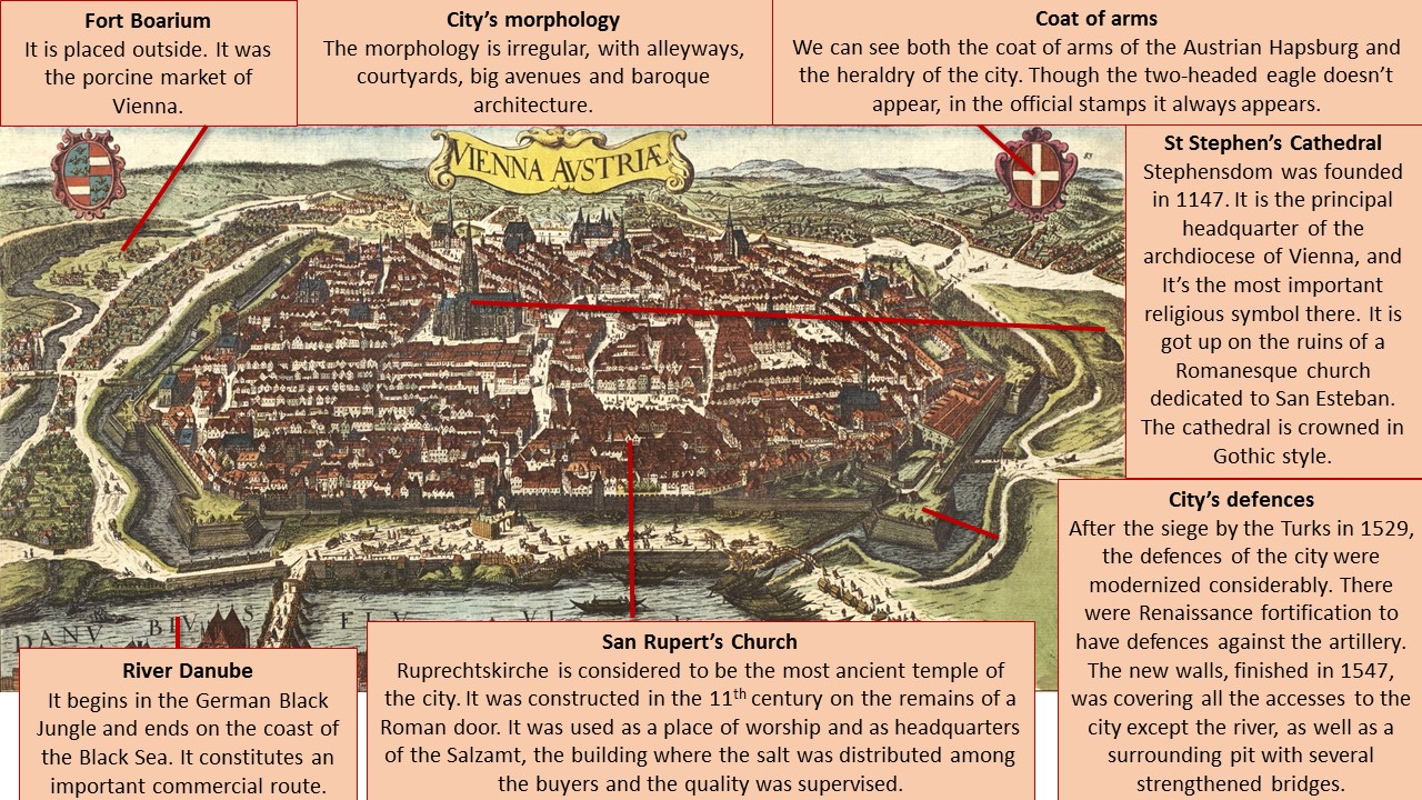
This image belongs to a collection of engravings of urban plans entitled Civitates Orbis Terrarum, published by Georg Braun, a German geographer and cartographer, and Franz Hogenberg, a German painter and engraver. This work was conducted between 1572 and 1617, just before the extensive devastation caused by the Thirty Year’s War. This great city atlas eventually contained 546 prospects, bird-eye views and map views of cities from all over the world. Among them we can admire this representation of the imperial capital of Austria, Vienna.
Vienna is placed on the riverside of the Danube river, in the oriental part of Austria. The river connects Central Europe to the Black Sea and has been used as a natural border many times throughout history. Concerning its specific geographical location, Vienna is in the Valley of the Vienna Woods, at the foot of the foothills of the Alps. The appearance of the city seems to be irregular, though we can see zones on the bottom left that looks like orthogonal. The property consist of medieval core, a former military Roman camp. Its remains stills visible in the urban medieval fabric of streets and alleys. In the 12th century, the urban development expanded beyond the Roman defences, which were demolished. The walls of the medieval city surrounded a much bigger area and were reconstructed after the Ottoman conflicts in the 16th and 17th century. The urban and architectural qualities of the Historical Centre of Vienna give exceptional testimony for a constant exchange of values along the second millennium.
Concerning the buildings inside the city, they show the big changes that the city of Vienna experienced from the Middle Ages to the Renaissance, as the Baroque period had not begun yet. This bird-view is considered to be one of the principal historical sources to know the appearance of the Gothic architecture of the city. Supposing that the monastic complexes and churches were generally constructed of stone, the residential neighbourhoods were of wood and suffered frequent fires. Out of the wall there are also houses, which is typical of the cities of the Modern Age because the medieval hulls were insufficient. The cities incorporated squares, gardens, sewerage, paving, etc. in their streets. The biggest and more significant streets were placed downtown, around important elements, as St Stephen’s Cathedral.
Thus, the interior of this city contains a number of medieval historic buildings, including the Schottenstift (the oldest monastery in Austria), the churches of Maria am Gestade (one of the most emblematic Gothic structures), Michaelerkirche, Minoritenkirche and Minoritenkloster. Saint Stephen Cathedral is dated between the fourteenth and fifteenth centuries, and clearly dominates the picture. It is crowned by a needle-shaped tower (Steffl), built in Gothic style, which is one of the most important religious symbols of Vienna.
Regarding the social activities, in the town centre there is a square where it is very possible that people devote to trade among other activities. Just outside the walls there are different groups of population: people at the top of the image seems to practice animal husbandry or trade. As we go down to the left, we can see men carrying goods. Then we stumbled upon the “Fort Boarium”, or the pork market of Vienna; and below we can see some passenger cars pulled along by horses. In the foreground we can see a large number of people carrying things and some of them look like being warriors. In the river we can see many boats, some fishermen and other merchants, because the salt trade was an essential activity at that time; although there are people who walk by crossing the bridges they had. The boats were made of wood to the edge that is on the right. At the top right, we see a line of people waiting to enter into the city, so we assume they were new immigrants in Vienna. The landscape in the surrounding area is formed by green plains, so we can deduce that agricultural activities are practiced. In the background of the image we can see a few mountains; on the other hand, in the foreground there is a river. The nearness of this one offers to the city supply of water and fish, and provides a trade route. We cannot forget that access to raw materials is essential in order that a city could develop correctly.
The imperial family Habsburg reigned in Austria and other Central European countries from 1278 to 1918. The struggles between Catholics and Protestants (Habsburg defended Catholicism) and the Turkish threat overshadowed the political life of Austria in the 16th and 17th centuries. The Peace of Westphalia (1648) and the Peace of Carlowitz (1699) ended, respectively, to both problems and consolidated the position of Austria as a European power. The Habsburgs made the city their capital from 1556 and its importance was enhanced with the expansion by the valley of the Danube. It became a core of European Baroque thanks to the construction of major architectural works and musical creations (from the 16th century, Vienna has been universally recognized as the musical capital of Europe).
Olga Arriero Gallego

