SANTO DOMINGO (John Ogilby, 1671)
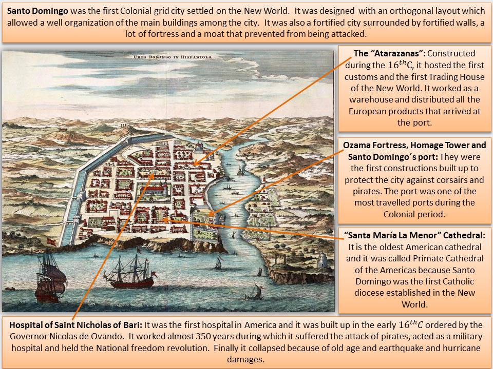
This image is a not drawn to scale perspective map of Santo Domingo city. It was made in 1671 by John Ogilby, a Scottish cartographer and translator who lived in London during the 17th century. The map was included in Ogilby’s work called America: Being the Latest, and Most Accurate Description of the New World, which was an expanded and hand coloured translation based on a book published in Amsterdam by Arnoldus Montanus. This draw is an antique map part of a group of volumes characteristic of sixteenth and seventeenth centuries where text, maps and illustrations about the European colorizations were joined.
This bird’s eye view shows the first European city founded in the New World in the 15th century on the southeastern coast of the island of Hispaniola, on the Caribbean Sea. As it appears in the map, the proximity to the sea and the river facilitated the protection of the city. While the sharp cliffs created a natural defence, the river meant the water supply and thus the existence of crops and other tropical plantations that can be appreciated in the bottom right part of the image. Furthermore the river mouth provided a natural sheltered port.
This city was firstly founded by Bartholomew Columbus in 1496 on the right bank of the Ozama River and then, after being destroyed by a hurricane, it moved to its current location on the left bank in 1502. The first building, which construction was initiated by the Governor Nicolás de Ovando to protect the city against corsairs and pirates, was the Ozama fortress. From then, the whole city was edified surrounded by a fortified perimeter with city walls, towers and a moat that provides it with the appearance of a defensive city as the map depicts.
Concerning the town planning, Santo Domingo was built up during the first half of the 16th century following an orthogonal plan with a well-structured street layout and many parks and green areas, serving as an essential point of reference for the construction of the Colonial grid cities. On the left margin, the map highlights the defence wall with the main entrances that lead into the principal roads such as the Royal Coast Road which connected Santo Domingo with San Iago and Azua. In addition, on the background, the “Casa Consistorial” or the “Cabildo” stands out from the rest of the constructions because of its size, so it could mean that it had an important function on the city life as it was the town council.
During colonial times and even now, Ozama’s port has been really important for the city’s economic development, becoming the centre of economic activities in the Dominican Republic. Besides, the trading activity had made this port the busiest port in the country over time. The port facilitated trades, and it was the point from where many colonization expeditions headed by famous explorers such as Ponce de León, Vasco Núñez de Balboa or Hernán Cortés were launched. The city was favoured and enriched because of both foreign and internal trade and so many explorers owned a house, as Hernán Cortés’ house that appears in the map, and created jobs for the indigenous people that still inhabited the region. It is important to mention, that the good location of the city and the port facilities not only provided satisfactions since it led into frequent assaults, loots and pillages. The most known attack was carried by an English corsair called Francis Drake who devastated and destroyed the city for ransom. Despite this, Santo Domingo has been always a trade city in which cultural, economic and religious activities took place.
Clara Moreno Lator

