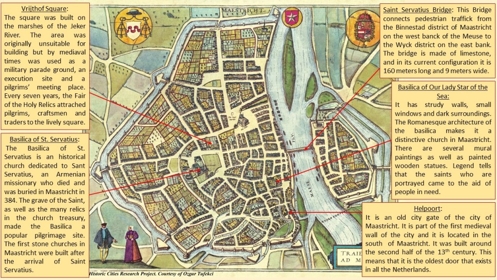
This work of art is part of a book named Civitaes Orbis Terrarum, writen and painted by the geographer Georg Braun and the painter and mapmaker Frans Hogenberg. This book contains 546 maps of cities from all around the world. This particular painting represents the city of Maastricht in the second half of the 16th century.
Maastricht is located in the southeastern of the Netherlands. It lies along the Meuse River at the junction of the Juliana, Liège-Maastricht and Zuid-Willems canals. It is the principal city in the southeastern appendix of the Netherlands and is only three kilometers from the Belgian border. It was the site for a Roman settlement and later the seat of a bishop, from 382 to 721. The town was held by the dukes of Brabant after 1204. Then it was taken by the Spanish in 1579, by Prince Frederick Henry of Orange in 1632, and by the French in 1673. After so many wars, in the 19th century only some portions of its old fortifications remained, such as Heelport and the Pater Fink Tower. After been attacked on the first day of the German invasion of the Low Countries in 1940, Maastricht was the first Dutch town to be liberated four years later, in 1944.
The image perfectly shows the city structure and layout to be defined by the city wall and Mosa river. The urban layout is radio-centric with the Basilica of Saint Servatius on the centre. We can find some open spaces for social activities as the churches and squares with long and wide streets that connects each other building.
Maastricht’s landmarks include the St. Servatius Bridge (c. 1280) over the Meuse; the Dinghuis, or former courthouse (c. 1475); and the Town Hall (1658–64). The cathedral, dedicated to St. Servatius, was founded by Bishop Monulphus in the 6th century; it is the oldest church in The Netherlands, although rebuilt and enlarged from the 11th to the 15th century. The Protestant Church of St. John, with a 246-foot (75-metre) tower, originally served as its parish church. The much-restored Church of Our Lady has remnants of 10th-century crypts. There are many other medieval churches, as well as fine houses in regional Renaissance and French styles. Maastricht is the site of the University of Limburg (1976), a music conservatory, a symphony orchestra, art academies, and several museums.
To the south you can see the sandstone quarries of St. Pietersberg, comprising more than 322 kilometers of underground man-made passages worked from Roman times to the 19th century. They were used to hide peasants and cattle during the wars against Spain as well as art treasures and refugees during the Second World War. There are four castles in the neighborhood of Maastricht.
An early trade was carried on in cloth, leather, hardware, and building materials. Until the coming of the railways in 1853, however, Maastricht did not reap the full advantages of its central position between the mining and industrial cities of Heerlen and Kampen (both in The Netherlands), Aachen (in Germany), and Liège (in Belgium). Its manufactures now include pottery, glass, crystal, cement, and paper. Tourism and printing are important, and there is a trade in beer, grain, vegetables, and butter.
Today this city is very well known because in 1991 the Maastricht Treaty was signed by the European Communities calling for the establishment of a European Union, with common policies on economics, foreign affairs, security and immigration.
Esther López Cámara

