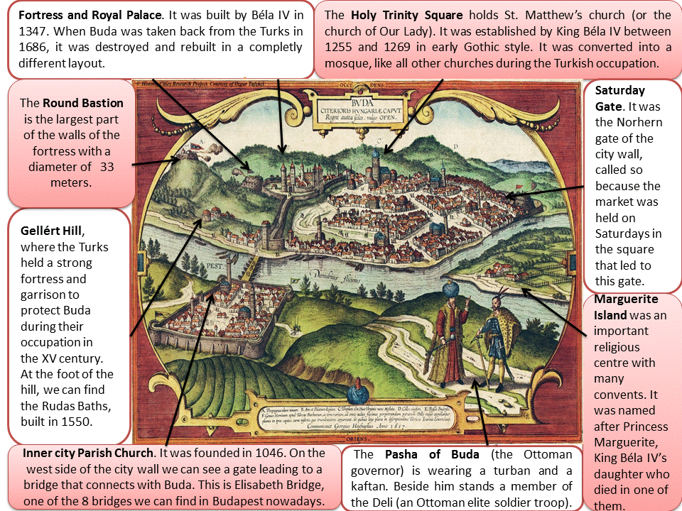
This antique hand coloured copperplate engraving represents the cities of Buda and Pest. It can be found in the magnificent Renaissance work on the cities of the world, Civitates Orbis Terrarum, a great city atlas edited by Georg Braun at the end of the 16th century with the cooperation of the painter and cartographer Franz Hogenberg. The Civitates was conceived as a companion for the Theatrum Orbis Terrarum, another contemporary world atlas made by Abraham Ortelius in the same era. More than a hundred artists and cartographers engraved the copper plates of the Civitates after drawings, among which is the author of this picture, Georg Hoefnagel.
Their work is a graphic testimony that shows us relevant aspects of the morphology and life style in the cities of the 16th century, a complete history lesson by itself. If we look at the cartouche at the bottom of the work, we can see a text in Latin added by Braun pointing out some places and cultural aspects, like the explanation about the identity of the two figures on local dress that appear at the foreground of the work: the Pasha of Buda and an elite troop soldier.
This engraving represents a bird’s eye view from an east perspective overlooking at the cities of Buda and Pest crossed by the Danube river during the Ottoman occupation, which happened between 1526 and 1686. The cites of Buda and Pest became Budapest on 1873 after their unification with Óbuda, another city that was 9 Kms up north along the Danube river, where the Romans had established Aquincum, the capital of their Pannonia province in 35 BC. They built the first public baths taking profit of the thermal springs they discovered in the area (Aquincum means “abundant in water”). They also established a fortress, “Contra Aquincum”, which remains stand in Pest, at the north of the Inner City Parish Church, pointed out in the image.
In the 9th century, the ancestors of current Hungarians arrived from the Ural Mountains and settled down along the Danube in the Carpathian Basin. On the 13th century, after suffering a Mongolian invasion, King Béla IV built a fortress on Buda Hills in order to provide defense against future attacks. He had sworn an oath that if he beat back the Mongols, he would offer his daughter, Princess Margaret, to the service of God. Being true to his oath he built a church and a convent on the island, where she had to live until she died. The island is known today as Margaret Island, ant it can be seen on the right hand side of the image.
Under King Matthias Corvinus reign in the 15th century, Buda became a renowned city throughout Europe as one of the centers of Renaissance humanist culture. Matthias church, the most important Catholic church that was built during his reign, is located up in the middle of the engraving. The city wall in Pest was built during this period, but it wasn’t enough to stop the Turks invasion in 1526.
This is the historical context in which this engraving was made. The Turks converted all churches into mosques, this is why we can see so many domes in both cities. They also built a fortress on top of Géllert Hill, a 140 m. high dolomite rock rising above the Danube in Buda, important for strategic defense and potential control of Central Europe’s main waterway to its inhabitants. We can locate it at the top left of the engraving. At the feet we can still visit the Rudas Baths, built in Islamic style.
The morphology of both cities has been influenced by these historical facts. Buda was constructed around the castle to fulfill the needs of the new dwellers that settled down after the court was brought on 1347. This accelerated the flourishing of the city and the Castle was enlarged into a Gothic Palace, placed at the top left hand side of the picture. We can observe many neighborhoods attending to the social hierarchy, religion or profession, separated by main streets and big squares, important places for social events like “Saturday Market”, located at the north of Buda. Pest follows the same pattern, but in this case the constructions are around churches. We can see a very big square in the center because Pest functioned during this period as the outskirts of Buda and developed into a crafts and trade city.
If we take a closer look, we can observe people carrying weapons or riding horses wearing armors throughout these streets that form an irregular town planning. This reminds us that they were submitted to the Turks at this time. The Danube river is very important for economic reasons because it offered transportation and irrigation for the fertile lands in flat Pest that made it a perfect place to raise crops. On the other side of the Danube, in the hill of Buda vineyards had already been cultivated since Roman times.
The Ottoman occupation lasted until 1686 when it was liberated by a Christian army. The Turks left the city devastated after their withdrawal and had to be reconstructed, entering a new age of prosperity in the 18th and 19th centuries, when Budapest became a global city after the 1873 unification.
Xilia Morales Jiménez.

