
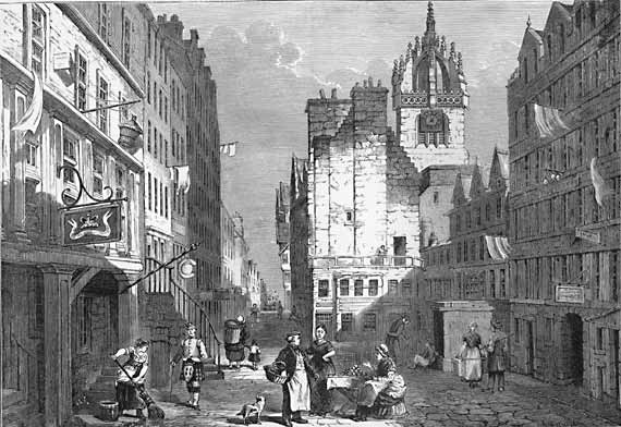
This image is an engraving which is included in the book ‘Old & New Edinburgh’ 1890, which deals with the history of the Scottish city of Edinburgh. It is a lithograph of AK Johnston issued in 1852 that represents a section of the Royal Mile in Edinburgh. AK Johnston (1844-1879) was a young and dedicated geographer who studied in the Edinburgh Institution and Grange House School. Johnston, at the beginning, was superintendent of the drawing but in 1868 he was chosen a life member of the Royal Geographical Society. In June 1869 he was assigned to be in charge of the geographical department of the London branch of Messrs. W. & AK Johnston business. In 1878 he was appointed leader of the expedition of the Royal Geographical Society.
Edinburgh is the capital of Scotland (UK), located on the shores of the River Forth and the East coast of Scotland; it is also the headquarters of the Scottish Government. Something that should be noted about Edinburgh is that the Old Town and New Town were awarded World Heritage by UNESCO in 1995. Edinburgh has 477.660 inhabitants but when its famous international festival is celebrated, this number is doubled. Edinburg was one of the most important centers of education and culture during the Enlightenment thanks to the University of Edinburgh. As I said before, Edinburgh is divided in two parts: the Old Town and the New Town.
The Old Town (as it is shown in the picture) has the same medieval structure and a lot of buildings from the protestant reform. In that place of the city we can highlight some squares, St. Giles Cathedral, the university of Edinburgh, museums and various subterranean streets… but one of the most important buildings of the city is its Castle ,which is located at the top of the hill that is communicated by the High Street. This Old Town was the first city of houses and apartments located on a high relief.
The New Town appeared as an answer to the overpopulation of the Old one in the 18th Century. There was a contest to design the new map of the city in 1766. Finally, James Craig, who was a young architect, was the winner. He made an orthogonal planning in which its main streets would be Princes Street, which is nowadays an important shopping place, and Queen Street.
This image belongs to a section of the Royal Mile. The Royal Mile is a succession of streets that communicate the Castle of Edinburgh to Holyroodhouse Palace. This avenue is divided in four parts or places: Castlehill, Lawnmarket, High Street and Canongate. We can appreciate two of the parts in the image: Lawnmarket and High Street. The bottom of the picture corresponds to Lawnmarket, which is a part of the Royal Mile designed for trade. Lawnmarket was originally on High Street and it was a place where they sold thread, cloth, and linen wear. This zone was also called Inland Merchandise and the merchants put their stalls and tents to sell their fabrics in the sides and in the middle of the street. Lawnmarket is situated at the bottom of the picture. As I said before, the image presents a medieval structure, and we can appreciate, in the bottom of the picture, different commercial activities. Finally we can highlight some people in this part of the picture; it seems that they are carrying out the commercial activities of the time.
High Street is the main issue of this graving. This is the avenue that goes from the Castle to the Palace. In this street (in the picture) we have to highlight Old Tolbooth (the old municipal prison) and St Giles Cathedral. Old Tolbooth was a prison where executions and tortures were something common in that era. The North Berwick witches trials were brought here and the prisoners sometimes wore iron collars for chaining up offenders in public view. The prison was demolished in 1817 because it made the High Street very narrow and promoted an unhygienic environment. Instead, in its place, a heart shape formed by paving stones was put on the floor marking the entrance of the old building. This heart is known as the Heart of Midlothian (the title of the graving). Another important building is St Giles Cathedral that is shown in the image.
St Giles Cathedral is the main place of worship of the Church of Scotland in Edinburgh. It was a very important religious place during the last 900 years. Today it is the Mother Church of Presbyterianism that is focused in St Giles, the patron of the city. In 1877 the Cathedral was divided into three different churches, one of them was the Thistle Chapel which was built in 1911 at the South-East corner of the church, that presents great and extraordinary details.
Laura Cabrera Sanz
Yo no estoy de acuerdo con lo aqui expuesto, pienso sinceramente que hay muchos factores que no han podido ser tenidos en cuenta. Pero valoro mucho vuestra opinion, es un buena web.
Saludos
It is an interesting project. I would like to visit Edinburgh and this project help me to know more information about this city.